Showing 1401 items
matching bending
-
 Bendigo Military Museum
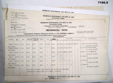
Document - MECHANICAL TEST RESULTS WW2, Thompson's Engineering and Pipe Works, 1942
By referring to Cat No 7237.2 this will bring up all associated items with Thompsons.This is a set of nine pages of steel, marine engine parts and naval gun parts - testing. The sheets have the letterhead of Thompsons Engineering and Pipe Co Ltd., Castlemaine. The results are to the Commonwealth of Australia 1 - 4. Marine Engine Parts. Dated 1945- 46 5 - 6. 4" Naval gun parts tests. Dated 1942. 7. Corvette Marine engine parts. Dated 1942. 8. Breach blocks for CQF M4 XIX ?? Dated 1942. 9. Tensile & bend tests Steel. Dated 1942.steel testing, marine engine parts -
 Federation University Historical Collection
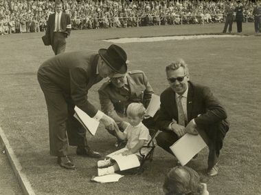
Photograph - Black and White, Foto: Vinders, Frank Wright, Officials and Child at Kerkrade, 1960's
Frank Wright was a renown resident of Smeaton, where he was born. He lived at Laura Villa, and attended Smeaton State School. His father William was a gold miner and his mother's name was Sarah. Their family won many singing and instrumental awards. Frank was tutored by Percy Code and was awarded a gold medal for the highest marks in the ALCM examinations in the British Colonies at the age of seventeen years. He became the Australian Open Cornet Champion by the age of eighteen. A year later, Frank conducted the City of Ballarat Band, and later the Ballarat Soldiers’ Memorial Band. He formed the Frank Wright Frisco Band and Frank Wright and his Coliseum Orchestra. These bands won many South Street awards, and Frank as conductor won many awards in the Australian Band Championship contest. In 1933 Frank Wright sailed to England to conduct the famous St Hilda’s Band and was later appointed Musical Director of the London County Council, where he organized many amazing concerts in parks, in and around the London district. He was made Professor of Brass and Military Band Scoring and conducted at the Guildhall of Music and Drama. Frank was often invited to adjudicate Brass Band Championships around Europe, in Australia, including South Street and in New Zealand. The Frank Wright Medal at the Royal South Street competition is awarded to an individual recognized as making an outstanding contribution to brass music in Australia.Black and white photograph of three men and a child. A man, Frank Wright, is bending down to shake the hand of a young boy who is seated on a small chair in the middle of a sports ground. Squatting next to him is another man, possibly his father and behind the child is a man dressed in a uniform. At the bottom of the photo, the head of another photographer can just be seen. In the background can be seen a large audience in the stands and several officials are standing watching the interaction between Frank and the child. The place is Kerkrade, the Netherlands.Hand written on the front of the mounting board - Foto Vindersfrank wright, foto vinders, kerkrade -
 Port Melbourne Historical & Preservation Society
Plan, "State Bank of Victoria - Proposed dwelling Fishermans Bend"
Plans were brought to us for copying 19.05.2011 by CBA employee Steve Tserkezidis, who has access to old State Bank records. Borrowed for scanning by Gavin Rowson who put them on CD and returned 07.06.2011From series of State Bankhouse plans and elevations of types 1 - 8. A1 copies (.01) 1937 (stamp). (.02) 1928. (.03) 1937. (.04) 1937. (.05) no date. (.06) 1928. (.07) 1937. (.08) 1938. From plans accompanying bank House plans .01 to .08; (.09) MMBW plan showing bank properties (.10) Bank house plan: sections through walls. (.11) "Fishermans bend group" plan of properties (.12) Bank House plan of Pier Foundationgarden city, built environment - domestic, state savings bank of victoria, bank houses -
 Kew Historical Society Inc
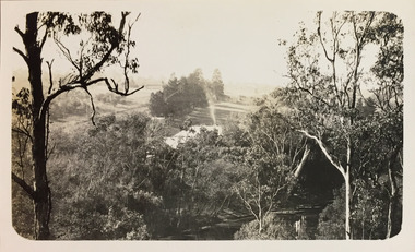
Photograph - Macauley's, Kew, 1924
Henry Beater Christian (1886-1962) , was a descendant of one of the earliest settler families in Kew. Employed at the Kew Asylum as a 'public servant', he was a skilled amateur photographer, photographing numerous scenes in Kew and on his travels around Victoria. The majority of his photographs date from 1916 to 1929. His finest photographs are housed in two photograph albums. A very rare, early panoramic view of Macauley's boat house on the Yarra River at Kew.Digital copy of a photograph from page 2 of the 47-page photograph album containing 261 gelatinous silver images, loaned by Diane Washfold with permission given to digitise and hold a copy in our collection. The photograph is of Macauley's boat sheds on the Yarra River at Kew. The boat sheds was located at the west end of Molesworth Street. The photograph is taken from the Yarra Bend Park side of the river looking down on the boat house from above. The canoes belonging to Macauley's are lined up on the river bank. "Macauley’s Kew"henry beater christian (1886-1962), landscape photography, kew (vic.) — yarra river, christian-washfold collection, photograph albums, macauley's boat sheds -
 Kew Historical Society Inc
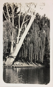
Photograph - Macauley's, Kew, 1924
Henry Beater Christian (1886-1962) , was a descendant of one of the earliest settler families in Kew. Employed at the Kew Asylum as a 'public servant', he was a skilled amateur photographer, photographing numerous scenes in Kew and on his travels around Victoria. The majority of his photographs date from 1916 to 1929. His finest photographs are housed in two photograph albums. A fine, early view of the river bank at Macauley's boat sheds on the Yarra River at Kew.Digital copy of a photograph from page 2 of the 47-page photograph album containing 261 gelatinous silver images, loaned by Diane Washfold with permission given to digitise and hold a copy in our collection. The photograph is of the river bank at Macauley's boat sheds on the Yarra River at Kew. The boat sheds were located at the west end of Molesworth Street. The photograph is taken from the Yarra Bend Park side of the river, or from a boat on the river. A group, probably members of the photographer's family, are sitting underneath a giant weeping willow."Macauley’s Kew"henry beater christian (1886-1962), landscape photography, kew (vic.) — yarra river, christian-washfold collection, photograph albums, macauley's boat sheds -
 Kew Historical Society Inc
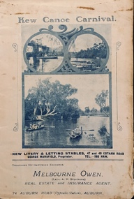
Programme, Kew Canoe Carnival, 1910
An item from an outstanding and diverse photographic collection, assembled by members of the Christian and Washfold families of Kew.Rare programme for what was once an annual event in Kew with important, possibly unique photos of sites in Kew and on the Yarra.Programme for the 1910 Kew Canoe Carnival which was held on the River Yarra on February 11th. The location was at the Asylum Reserve at the old white bridge (the precursor of Kane's Bridge). Funds were raised in Aid of the Annual Treat to Kew and Yarra Bend Patients (and the Carnival fund). The booklet includes details of the programme, numerous advertisements and rare and important historic photographs of the district including: the Willsmere Park Dairy, the Glen Tea Gardens at Hawthorn, the Pipe Bridge, the Kew Boat Sheds (Macauley's), and Rudder Grange boat house.christian-washfold collection, kew canoe club, kew canoe carnivals -
 Melbourne Tram Museum
Pamphlet, Keolis Downer, "Experts in all stages of Infrastructure Life Cycle", c2015
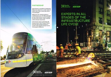
Pamphlet - four fold A3, printed on heavy paper, titled "Experts in all stages of Infrastructure Life Cycle", advertising Keolis Downer abilities in tram track and other rail based work including light rail, key supplier international relationships, description of Yarra's network - statistics, photos of E 6001 and E 6005. Has centre page spread of the civil construction activities at tram stops, the rail bender and the reconstruction of the intersection of Nicholson and Victoria Parade intersection. Has Keolis Downer and Yarra Trams logos.trams, tramways, yarra trams, construction, keolis, victoria parade, nicholson st, trackwork, overhead, statistics -
 Melbourne Tram Museum
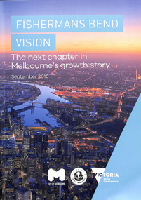
Document - Report, City of Melbourne, "Fisherman's Bend Vision - the next chapter in Melbourne's growth story September 2016", Sep. 2016
Report - 44 pages, A4 card cover perfect bound titled "Fisherman's Bend Vision - the next chapter in Melbourne's growth story September 2016", with a photo of Docklands, looking west. Published jointly by the City of Melbourne, City of Port Phillip and the State Government following on from Draft document of 2013. Has a table of contents. Looks at the Strategic Directions for the development of the area, Has a sketch of a tram in Plummer St, Wirraway. Refers to a website www.fishermansbend.vic.gov.au on the rear cover - active as at 18/5/2020.trams, tramways, city of melbourne, city of port phillip, fishermen's bend, new tramway, public transport, development, planning -
 Hume City Civic Collection
Photograph, late 1970s
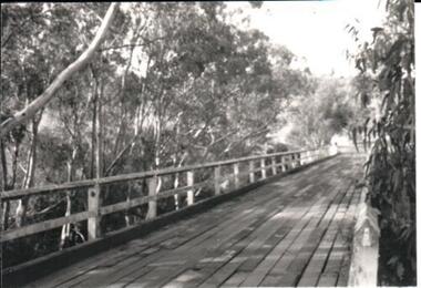
The photograph was taken before the wooden Holden Bridge which spans an arm of the Deep Creek at Bulla was replaced by a more sunstantial concrete structure. As well as building a new bridge, the sharp bend and approach to the old bridge was also removed.A black and white photograph of a wooden road bridge with eucalypt trees growing on either side of the bridge.bridges, holden bridge, shire of bulla, george evans collection -
Port Melbourne Historical & Preservation Society
Pamphlet - The Pubs of Port 2001, Pat Grainger, Walks around Vintage Port No.6, 2001
Update and reprint of Pubs in Port Walk (No 7). Project Assisted by CoPP. The original Pubs in Port Walk was No 7 with No 6 reserved for Bend on the River: Westgate Park. The Westgate Park walk was not produced so on this updated version the Pub walk became No 6.Port Melbourne Historical and Preservation Society publication, "Walks around Vintage Port", "No.6 Pubs of Port" 2001 Edition.hotels, built environment -
 Bendigo Historical Society Inc.
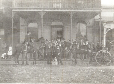
Photograph - ORIENTAL BANK: EAGLEHAWK, 1860's ?
black and white photo mounted on same size board. Group of 30 men and boys outside double storey building with verandah with iron lace. At left man mounted on horse. At rigfht, horse and 4 wheeled vehicle. At centre 2 men, 1 each side of box with '1311' 4 pieces of smooth material piled on box ( smelted gold ? ) At far left, 2 girls, 1 bending down. On left hand window of building 'old' On RH window ' …. Mercial bank'? Above doorway at far left ' private entrance'organization, business, oriental bank, eaglehawk -
Port Melbourne Historical & Preservation Society
Plan - CD-ROM, "State Bank of Victoria - Proposed dwelling Fishermans Bend"
Plans were brought to us by CBA employee Steve Tserkezidis CD with items below. From series of State Bankhouse plans and elevations of types 1 - 8. A1 copies (.01) 1937 (stamp). (.02) 1928. (.03) 1937. (.04) 1937. (.05) no date. (.06) 1928. (.07) 1937. (.08) 1938. From plans accompanying bank House plans .01 to .08; (.09) MMBW plan showing bank properties (.10) Bank house plan: sections through walls. (.11) "Fishermans bend group" plan of properties (.12) Bank House plan of Pier Foundationgarden city, built environment - domestic, state savings bank of victoria, bank houses -
 Kew Historical Society Inc
Photograph - Zig-Zag Bridge on the Yarra River at Kew, 1924
Henry Beater Christian (1886-1962) , was a descendant of one of the earliest settler families in Kew. Employed at the Kew Asylum as a 'public servant', he was a skilled amateur photographer, photographing numerous scenes in Kew and on his travels around Victoria. The majority of his photographs date from 1916 to 1929. His finest photographs are housed in two photograph albums. Digital copy of a photograph from page 8 of the 47-page photograph album containing 261 gelatinous silver images, loaned by Diane Washfold with permission given to digitise and hold a copy in our collection. The Zig-Zag Bridge linked the grounds of the Yarra Bend and Kew Asylums. The wooden bridge was constructed in the 1870s and lasted through numerous floods until its destruction in 1929. A horizontal structure, the walkway was reached via a wooden staircase on the Kew side. The steps were required due to the different levels of the banks on this stretch of the river. "Zig-Zag Bridge"henry beater christian (1886-1962), landscape photography, kew (vic.) — yarra river, christian-washfold collection, photograph albums, zig-zag bridge -
Moorabbin Air Museum
Document (item) - Various aircraft photos and drawings see description, CAC Misc documents and design drawings of various aircraft
xyz -
 Royal District Nursing Service (now known as Bolton Clarke)
Photograph - Photograph, black and white, Barry Sutton, 22.06.1977
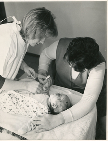
The RDNS Sister is visiting the mother and babe in their home. She is using sterile equipment and swabs to firstly moisten the tulle gras to enable ease of its removal before redressing the open areas on the babes skin with sterile dressings. With RDNS visiting the home of the mother, the young babes routine can continue to be established at home, rather than them having to regularly visit a Doctor or Hospital department for redressing of the babes lesions. The Trained nurses (Nurses) of the Melbourne District Nursing Society (MDNS), from its inception in 1885, provided wound care to their patients who ranged in age from the very young to the elderly. The patients required their wounds to be dressed following various types of surgery, accidents, burns, skin conditions, cancer, leg ulcers etc. As research developed better products and dressing materials, the methods and medication applied to wounds changed. MDNS received Royal patronage in 1966 and as Royal District Nursing Service (RDNS), the Education department developed wound care programs, such as the Leg Ulcer Management Program to provide their Trained nurses (Sisters) with methods of best quality care. They ran a program for Wound Care Specialists who made assessments and provided advice and support to the District Sisters working in the field as needed. The Sisters liaised with the patient’s Doctors and Hospitals to provide information on the progress of patient’s wounds and to receive any change of wound care from the Doctors. On the left in the black and white photograph is a Royal District Nursing Service (RDNS), Sister, who has short, straight blonde hair, and is wearing a white gown over her uniform is bending over a bassinet as she attends a baby with a skin condition. The Sister has her arms extended with a pair of forceps in her left hand, and in her right hand, another pair of forceps with a cotton wool swab attached is touching tulle gras on one of the wounds on the babes outstretched right arm. The baby is on her covered change table and is wearing a singlet and an opened patterned jumpsuit with her right upper area uncovered. Her mother, who has short dark hair and is wearing a dark sleeveless V neck tunic style frock over a light coloured long sleeve top, is behind and bending over the change table holding her babes right outstretched hand. She is also holding a dummy in that hand. The mother's left extended arm and hand is on the left shoulder of her babe. The baby, who has sparse hair, is looking up at her mother; signs of a skin condition can be seen on areas of the babes face and head.Photographer stamp. Quote No. DO 50royal district nursing service, rdns, rdns wound care -
 Kiewa Valley Historical Society
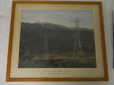
Framed photo - Mt Beauty Township & Main Transmission Line, 1954
This is a photo of Mount Beauty taken from a high vantage point near the hair-pin bend on the Tawonga Gap Road (half way up) in 1954. Mount Beauty was built by the State Electricity Commission of Victoria during the construction of the Kiewa Hydro Electric Scheme.This photo belonged to Mr & Mrs Gordon White SECV employee and long time residents of Mt Beauty.This is a framed coloured photo of the Mount Beauty Township and main Transmission Line from Mt Beauty to Kiewa. The photo has two transmission lines in the foreground with the Mt Beauty township in the background, but at the foot of Mount Bogong.Approx 1954 / Conroy-Moffatt Pty Ltd / Picture Framer / ..McKillop Street / Tel Mu .. 78 ....mt beauty; transmission line; tawonga gap road; kiewa hydro electric scheme -
 Port Melbourne Historical & Preservation Society
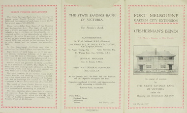
Pamphlet, Port Melbourne Garden City Extension
The State Savings Bank of Victoria transformed an area of Fisherman's Bend by creating Garden City. This 1927 pamphlet described the area and outlined the loan conditions. A small range of building designs had been developed based on designs used in England and Scotland for workmen's homes.1927 pamphlet issued by the State Savings Bank of Victoriabuilt environment - domestic, garden city, state savings bank of victoria -
 Vision Australia
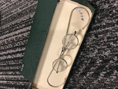
Functional object - Object, Spectacles
Pair of spectacles made of small circular thick lenses and long silver bendable arms. Price of $43.70 handwritten on the inside of the box. These glasses were donated from the Kooyong Low Vision Clinic, who used and sold them to clients until the 1980's. Green cardboard box holding a pair of silver spectaclesassistive devices, association for the blind -
 Port Melbourne Historical & Preservation Society
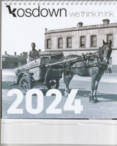
Document, Kosdown we think in ink 2024, 2023
The 2024 Kosdown calendar celebrates Port Melbourne and pays tribute to Pat GRAINGER and her contribution to the community and the Port Melbourne Historical & Preservation Society. Historic photographs include Swallow & Ariell's factory, motor racing at Fishermans Bend, and Mitchell's London Family Hotel.Spiral bound 2024 calendar on a stiff white cardboard stand. The cover has a photo of William STUART on his milk float and horse 'Goatie'..business & traders - dairies, kosdown press, pat grainger, business and traders - hotels, business & traders - manufacturing, mitchell's london family hotel, sport - motor racing, william raeburn stuart, goatie, swallow & ariell ltd, london family hotel -
 Eltham District Historical Society Inc
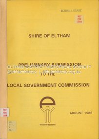
Document, Shire of Eltham, Shire of Eltham Preliminary submission to the Local Government Commission, August 1986
Report produced by the Shire of Eltham in August 1986 as a prelimary response to proposed municipal restructure in the state of Victorianon-fictionReport produced by the Shire of Eltham in August 1986 as a prelimary response to proposed municipal restructure in the state of Victoriacouncil amalgamation, annexation, rates -
 Mt Dandenong & District Historical Society Inc.
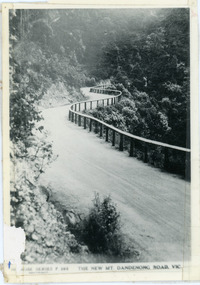
Photograph, The New Mt Dandenong Road, Vic
Copy of Rose Series postcard #385 showing the new Mt Dandenong Tourist Road with wooden railing fence on low side of road. Surface not yet made. This photograph has a detailed inscription on the back handwritten by John Lundy-Clarke in 1974.View downhill from the Windy Bend showing the site of the 1972 landslide. In this picture the road is running along the top edge of the wall 900’ thick of Kalorama Docite that plunges thousands of feet deep down into the earth below the Ranges and extends to Fern Tree Gully. It was once a horizontal terrace nearly ten miles square and tipped over to the left when the mountain subsided into its volcanic cauldron.mt dandenong road, rose series, windy bend, landslide -
 Port Melbourne Historical & Preservation Society
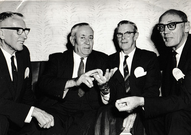
Photograph - The Official Opening of Rothman's tobacco products new Victorian Distribution Centre 1963, Laurie RICHARDS, 7 Feb 1963
Photograph of L - R unknown, Cr Mel FENNELL, Cr Les TURNER, Deputy Chairman of Rothmans of Pall Mall, Sir Kenneth COLE, at the Official Opening of' the company's Victorian Distribution Centre in Port Melbourne situated on Lorimer Street near Ingles Street Fishermen's Bend.B & W photograph of two City of Port Melbourne Councillors & the Chairman of Rothmans of Pall Mall (Australia) Ltd.On reverse pasted label with printed Compliments of Rothmans Of Pall Mall typed inscription : On the occasion of the Official Opening of the Rothmans new Victorian Distribution Centre on 7th February 1963. Handwritten - from Right to Left , ? , Cr Mel FERRELL, Cr Les TURNER, Sir Kenneth COLE (Deputy Chairman)leslie stanley turner, local government - city of port melbourne, rothmans of pall mall distribution centre, henry melville fennell, sir kenneth cole, built environment - commercial -
 Forests Commission Retired Personnel Association (FCRPA)
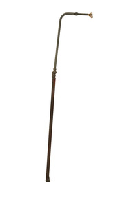
Burning wand - kerosene, c 1950
The origins of the humble handheld driptorch have been lost in time. They are widely used for ignition in controlled burning operations in forest and grasslands. This "home made" burner wand uses kerosene and dates from the 1950s. It has an unusual long handle with a bend and wick one one end.Unusual "home made" design Long handle burning wand with a wick at one end. Brass flow valve in the middle. Base attached to a container of kerosene and has a screw cap. bushfire, forests commission victoria (fcv) -
 Greensborough Historical Society
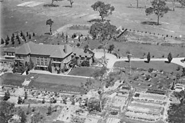
Photograph - Digital Image, Amberley Mansion from the air 1930s, 1930s
An aerial view of Amberley Mansion in Lower Plenty, taken during the 1930s. Amberley was built in the 1920 as a private residence and later as a centre for Christian Brothers. Located on a bend in the Yarra River and now known as Edmund Rice Centre Amberley, it is currently a conference centre, school camp and function centre.An example of an early 20th century building that has survived for over 100 year, with variations to its use.Digital copy of black and white photographamberley, edmund rice centre amberley, christian brothers, lower plenty -
Port Melbourne Historical & Preservation Society
Pamphlet - The Pubs of Port 2012, Pat Grainger, Walks around Vintage Port No.6, Jun 2012
Update and reprint of Pubs of Port Walk. Supported by CoPP. The original Pubs in Port Walk was No 7 with No 6 reserved for Bend on the River: Westgate Park. The Westgate Park walk was not produced so the first updated version the Pub walk in 2001 became No 6 and this version (2012) maintained that numbering.Port Melbourne Historical and Preservation Society publication, "Walks around Vintage Port", "No.6 Pubs of Port" 2012 Edition.hotels, built environment -
 Port Melbourne Historical & Preservation Society
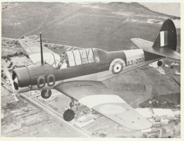
Photograph, Commonwealth Aircraft Corporation, Wackett Trainer
From a box of photographs in Nancy U'REN's papers used during research for her thesis, The Early Growth and Development of Sandridge (1976) and/or her book with Noel TURNBULL, A History of Port Melbourne (1983). The Wackett Trainer was designed in Australia and manufactured at the Commonwealth Aircraft Corporation factory on Fisherman's Bend.Black and white photograph from the Commonwealth Aircraft Corporation showing the Wackett Trainer airplane in flight.commonwealth aircraft corporation, wackett trainer, transport - aviation and aerodrome, nancy u'ren nee morris -
 Sunbury Family History and Heritage Society Inc.
Photograph, c1900s
The people in the horse and cart are driving their vehicle over the original Macedon Road bridge which spans the Jacksons Creek in Sunbury. In the 1970s the road was diverted to take out the downhill bend at the approach to the bridge and a newer bridge was built close to the original one, which now takes pedestrian traffic.The original Macedon Street bridge is one of five heritage bridges in Sunbury. Two of them are built along Macedon Street and the other three are along the railway line.A sepia photograph in post card format of two people in a horse and cart going over a bridge with trees on each side of them.macedon street bridge, jacksons creek, sunbury -
 Flagstaff Hill Maritime Museum and Village
Nail, circa 1810
This copper nail, sometimes known as a ‘Dumpy Bolt’ or spike, was salvaged from the hull of the wreck of the “George III”. It dates back to at least 1810. It was found by an abalone diver on the south east coast of Tasmania. The nail would have been used to hold the layers of the ship’s keel frame and the planking together. The nail has been passed from the abalone diver to an interested business man on a trip to the south of Hobart, on again to the business man’s close friend who then donated it to Flagstaff Hill Maritime Village. The metal of nails such as this one, after being in the sea for a long time, become affected by the natural reaction of the sea water, causing it to degenerate and thin, and the stress from the force of the sea over the years alters its shape. Iron nails had been used on ships previously, but they quickly corroded in the salt; ships needed regular, costly and time-consuming maintenance to replace the iron nails. Towards the end of the 18th century the British Navy trialled the use of copper nails, finding them to be very successful. Merchant ships began to adopt this process in the early 19th century, although it made ship building very expensive and was more often used for ships such as the “George III” that sailed on long voyages. The three masted sailing ship “George III” was a convict transport ship built in Deptford, England, in 1810. On 14th December 1834 she left Woolwich, England, bound for Hobart Town, Van Diemen’s Land (Tasmania), under Captain William Hall Moxey. She was carrying 220 male convicts plus crew, guards and their families, totalling 294 persons (another 2 were during the voyage). Amongst the cargo were military stores including several copper drums of gun powder. On 27th January 1835 the “George III” was near the Equator, about half way into her journey. A fire broke out and the gun powder was in danger of explosion, threatening the whole ship. Two convicts braved the heat and smoke, entered the store and seized the gun powder drums, suffering burns for their efforts but saving a probable disaster. The fire destroyed some of the provisions and food was scarce. Many became ill with scurvy and some died during the journey. Nearing the end of their journey on 10th April 1835 the “George III” was headed through the D'Entrecasteaux Channel, south east Tasmania, between the mainland and Bruny Island. She was sailing in the moonlit night to hasten her arrival in port due to the great number of sick on board. She struck uncharted rocks, known only to the local whalers, between Actaeon Reef and Southport Lagoon and within hours began to break up. The ship’s boats were used to first rescue the women and children. Firearms were used to help quell the panic of the convicts below decks and some were killed by the shots. Many convicts, including the sick, were drowned. In all, 133 lives were lost including 5 of the crew, guards and their families. It was the third worst shipping disaster in Tasmanian waters. A monument in honour of the prisoners who perished in the “George III” has been erected, noting the date of the wreck as “Friday 10th April 1835.” (NOTE: there are a few differences between sources regarding dates of the shipwreck, some saying March and others April 1835. There are also differences in the figures of those on board and the number of lives lost.) The copper nail is significant as an example of sailing ship construction; fasteners used in the early 19th century on ships carrying convicts to Australia. The nail is also significant for its association with the ship “George III”. The “George III” is registered on the Australian National Shipwreck Database, ID 7195 as an Historic Shipwreck. She is the third worst shipwreck in Tasmanian waters. She is also associated with Early Australian History and the transportation of convicts to Australia. The incident of the fire on board and the bravery of the convicts in making the gun powder safe is an example of the social character of the people in early Tasmanian colonisation. Copper nail (also called a Dumpy bolt or spike) from the convict ship George III, wrecked in 1835. Nail is long, bent in an ‘L’ shape about 3/5ths along, tapering from both ends to the bend. Both ends are flat and do not taper to a point, nor have a thread. The shorter end has been polished, showing bright copper. There is pitting along the nail and virdigris is evident on the longer, unpolished end. The nail is displayed with the longer section resting on a wooden board between two ‘U’ shaped uprights, the shorter section upright. flagstaff hill, warrnambool, shipwrecked coast, flagstaff hill maritime museum, maritime museum, shipwreck coast, flagstaff hill maritime village, great ocean road, george iii, ship construction, ship nail, 1835 shipwreck, 19th century shipwreck, william moxey, d'entrecasteaux channel, convict transportation, copper nail, dumpy bolt, spike, keel nail -
Bendigo Historical Society Inc.
Document - MINING REPORTS - MINE MANAGER'S REPORT TO WILLIAMS UNITED
Handwritten report from T. Banner, Mine Manager to Williams United, dated August 8, 1904, at request of Directors. Report is for the machinery at the York Shaft. Report mentions drums, ropes, length of rope on the drums, boiler which cannot work with safety up to more than 45 lbs., a good bend in the stack about 25 or 30 feet from the top and new wheels necessary. Also a report on the machinery at Central. Report mentions engine, drums, engine bed lifting a bit when bailing from the bottom, poppet legs, ropes and boiler.document, gold, mining reports, mining reports, mine manager's report to williams united, t banner, york shaft, central -
Bendigo Historical Society Inc.
Map - RAYWOOD GOLD FIELD MAP, 1902
Map. Raywood Gold Field Map. Linen backed map of Raywood and Neilborough Township and surrounds showing the location of varying underground workings. Surveyed by H S Whitelaw 1/6/02. It shows underground workings from The Perseverance Party and moreshed and Party and underground workings on the Old Pioneer Reef. Mentions the Parish of Yallook, Parish of Neilborough, Yarraberb, Mushroom Flat, Murray Valley Plain, Eaglehawk and Kerang Railway, Green Hill, Doughboy, Redmond's Gully, Pickpocket Lead, Raywood Lead, Inglewood Lead, Shaw's Road, Nuggety Shaft, Barkly Shaft, Maori Bendmap, gold field map, raywood gold field map, neilborough, h s whitelaw, geological survey of victoria bulletin no 12 plate 11