Showing 10928 items matching " plan"
-
 Federation University Historical Collection
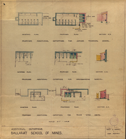
Plan, Ballarat School of Mines Additional Outoffices for Junior Technical School, 1952, 02/10/1952
Colour plan for outoffices, dressmaking and trade work shops.ballarat school of mines, buildings, percy everett, architectural plans -
 Federation University Historical Collection
Plan, Ballarat School of Mines New Workshops, Albert Street, 1944
The Ballarat School of Mines is the first School of Mines in Australia, and was established in 1870.Black ink on paper plan: SMB New Workshops plans, smb workshops, percy everett, smb, ballarat school of mines -
 Federation University Historical Collection
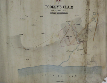
Plan, Tookey's Claim Moanataiari Creek, 1869?
Ink on paper plan with blue, red and orange shading tookey's claim, moanataiari creek -
 Federation University Historical Collection
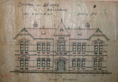
Plan, Ballarat School of Mines New Classrooms (now Administration Building), 1899, 16/02/1899
In 1900 this building was described as 'handsome in design, well lit, well ventilated, commodious - containing Council room, office, chemical laboratory, mineralogical laboratory, students room and six lecture rooms. Original hand coloured plan on linen of the Ballarat School of Mines New Classrooms (in 2014 known as the Federation University Australia SMB campus Administration Building). The plan shows the front elevation, section on line, ground and 1st floor plan. Copy in black frame with cream mount.ballarat school of mines, new classrooms, administration building, architectural plans, a building -
 Federation University Historical Collection
Plan - Architectural Plan, Architectural Plan for the Front Elevation of the Ballarat School of Mines New Classrooms, 1899
Framed original plan of the fron televation of Ballarat School of Mines New Classrooms (later called the Administration Building). ballarat school of mines, architectural plan, administration building, new classrooms -
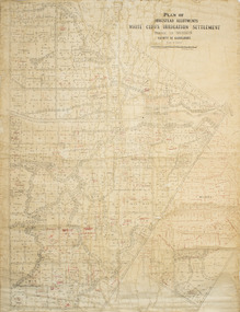 Merbein District Historical Society
Plan - Plan, Allotments, Plan of Homestead Allotments White Cliffs Irrigation Settlement Parish of Merbein County of Karkarooc
Large plan drawn in black ink on cream colour paper with linen backing. Some red ink addedWritten in red pen new owners of allotmentsallotments, merbein, irrigation, whitecliffs, county of karkarooc -
 Greensborough Historical Society
Map, Greensborough Map with Rail Line Plan, 1970s
Central Greensborough area, including railway line and some landowners. Basic map made c. 1902; annotations dated to circa 1970sTwo copies of planParish of Keelbundora, County of Bourke. Central Greensborough areagreensborough, greensborough railway station -
Whitehorse Historical Society Inc.
Map, Sample Plan
Sample Plan of Shireroad construction and maintenance -
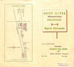 Ringwood and District Historical Society
Flyer, Ringwood Mail, Retail Subdivision Brochure - Plan of New Shop Sites, Ringwood, Victoria. - circa 1950
Double sided folded page advertising shop sites in Whitehorse Road, Ringwood, with locality plan, price list, terms of sale, summary of local facilities and services, and diagram showing layout of 9 retail allotments for sale. These sites were originally zoned as residential as part of the 1926 "Olive Grove Estate" subdivision. (See Vicorian Collections Reference 5169). The 9 new shops were later allocated street numbers 58 to 64 Whitehorse Road, Ringwood.Locality plan showing shop sites for sale on Whitehorse Road, Ringwood, between New Street and Olive Grove. Sole Agents: Ringwood Real Estate Co., Station Entrance, Ringwood, (Telephone) WU6661, WU6662. -
Whitehorse Historical Society Inc.
Document, Corporate Plan, 1993
City of Nunawading. Corporate Plan [1993-1995?]. 1993. Continued by: Whitehorse City Council. Corporate Plan.local government, city of nunawading -
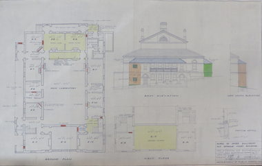 Federation University Historical Collection
Plan, School of Mines Ballarat Old Supreme Court Building, 1959, 26/10/1959
Copy of a plan and elevations of the former Ballarat Supreme Court, later a building of the Ballarat School of Mines. The plans were for repairs and painting of the Old Electrical School of the Ballarat School of Mines. former ballarat supreme court, electrical school, ballarat school of mines, painting -
Federation University Historical Collection
Plan - Architectural Plan, Architectural Plan for the Back and Flank Elevation of the Ballarat School of Mines New Classrooms, 1899
Framed original plan of the back and flank elevation of Ballarat School of Mines New Classrooms (later called the Administration Building). ballarat school of mines, architectural plan, administration building, new classrooms -
University of Melbourne, Burnley Campus Archives
Plan - Photocopy, Sketch Plan, 1929
Photocopy of hand drawn plan of Section of Site indicating proposed irrigation. Probably from A.W. Jessep memos 1929."From Jessep memos(?) 1929irrigation, a.w. jessep, burnley gardens -
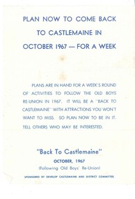 Old Castlemaine Schoolboys Association Inc.
Poster, Plan now to come back to Castlemaine in 1967
Plan now to come back to Castlemaine in October 1967 - for a week plans are in hand for a week's round of activities to follow the old boys reunion in 1967. It will be a back to Castlemaine with attractions you won't want to miss. So plan now to be in it. Tell others who may be interested. Sponsored by developed Castlemaine and district committee -
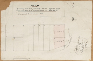 Bacchus Marsh & District Historical Society
Map, Plan showing relative positions of the Gisborne road formation and Mr. Cosgrove's land in Darley. 1907
No background information about the roadworks referred to in this plan has been found. The portion of land referred to as 'Cosgroves' in this plan is located close to the present day Darley Park Recreation Park in Darley, near Bacchus Marsh. The land indicated appears to be close to the corner of Grey Street and Gisborne Road. James Cosgrove who died in 1923 aged 65 owned a farm of 52 acres in this area of Darley.Single page map showing a proposed deviation of the Gisborne road in Darley and its position relative to land owned by Mr. Cosgrove. The land owned by Cosgrove is shaded in pink. No scale indicated. Part of a set of maps which are pasted into a bound volume containing 76 maps or plans in total. High resolution digital image stored on BMDHS computer network. Signature (illegible), Eng, Bac Marsh Shire, 30/9/07bacchus marsh roads and streets, darley victoria maps -
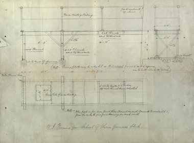 Federation University Historical Collection
Plan, W. I. Framing for School of Mines Furnace Sheds, 1908, 1908
Pencil drawings of plans for the Ballarat School of Mines Furnace Sheds.ballarat school of mines, assaying, w.i. framing -
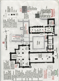 Ballarat Heritage Services
Plan, Lanercost Priory, Digital copy made 2016
Lanercost Priory was founded around 1169 by Robert de Vaux, and was home to an order of Augustinian canons until 1538 when is was dissolved by Henry VIII. In 1542 the priory and lands were granted to Thomas Dacre, an illegitimate son of Thomas, Lord Dacre. Mason's marks can be found throughout the undercroft. Plan on white paper with black and red ink printing and a drawingEnglish Heritage Lanercost Priorymason's marks, marks, stone marks, stonemasons, lanercost, priory, plan, 1169 -
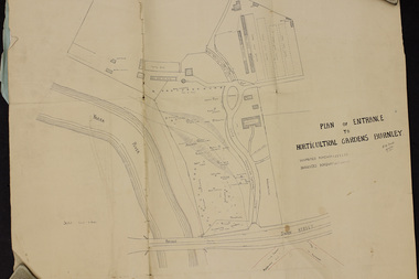 University of Melbourne, Burnley Campus Archives
Plan, Plan of Entrance to Horticultural Gardens Burnley, 1932
Copy of plan photographed at the Public Records Office Victoria. (1) Hand drawn plan signed by A.W. Jessep 8/12/32 with 'Suspected Roadway' and ' Suggested Roadway'. Scale 1 inch - 1 chain. Trees on East side named. (2) Memorandum to The Agricultural Superintendent dated 08.12.1932 'Re Proposed Boulevard Along the River Yarra' from the Principal A.W. Jessep. Plan had been to put road through the Lagoon Paddock and he suggested the route outside the Burnley College grounds.prov, burnley gardens, a.w. jessep -
University of Melbourne, Burnley Campus Archives
Plan, Base Plan Residential Landscape, 1994
2 plans on tracing paper dated 17.03.1994 and 23.03.1994. Same site, different anotation. Scale 1:100. Drawn by J.K.landscape design, residential -
University of Melbourne, Burnley Campus Archives
Plan, VCAH Burnley College, Swan Street Richmond - Site Plan 1:1000 Fire Services Survey, 1991
Plan with Buildings named, External Hydrant Sources and Main Entry Points marked. Scale 1:1000. Dated January 1991.vcah, burnley, fire safety -
Stawell Historical Society Inc
Map, Plan Shewing Position of Stawell, 1859
Plan Shewing Position of Stawellstawell -
Stawell Historical Society Inc
Map, Plan of Works on No1 Reservoir, 1896
Plan of Works on No1 Reservoirstawell, water -
Stawell Historical Society Inc
Map, Plan of the Agricultural Area of Callawadda, 1865
Plan of the Agricultural Area of Callawaddastawell -
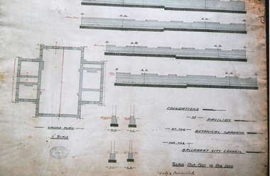 Friends of Ballarat Botanical Gardens History Group
Photograph - Digital image - jpg, Plan of Foundations for Gardens Pavilion, Ballaarat
Black and white photograph of planplans, ballaarat botanical gardens pavilion, circa 1890 -
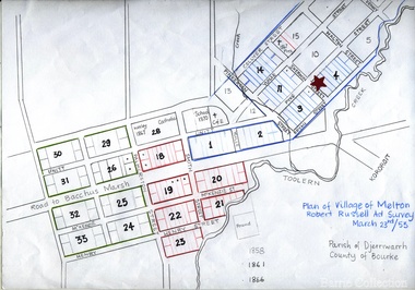 Melton City Libraries
Map, Plan for the Village of Melton, 1853
Site of early village Section numbers 1 - 17 Later became the Flat known as the Common Robert Russell – Surveyor Pinkerton, Sherwin, Bryan, Pyke, Yuille, CollyerMelton Town 1853 Plancouncil -
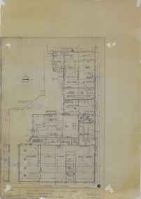
Federation University Historical Collection
Plan, New Engineering Building for Ballarat School of Mines, 1939, 13/06/1939
.1) West and South Elevations .2) East and North Elecation and floor plan .3) Sections E-F, M-N, O-P, G-H, Z (Excavations and retaining walls) .4) Site plan and details of Retaining Walls .5) Excavations and retaining walls .6) Site Plan and retaining walls chief architect, ballarat school of mines, saw-tooth, engineering, architectural drawing -
![Plan, Improvements on the Camp Reserve Ballarat, 1870, 26/4/1870 (exact); Traced by Henry [Mornes?], district surveyor, on the above date](/media/collectors/4f729f6797f83e0308601707/items/4f72a4fa97f83e0308602508/item-media/59b79d3921ea680200c6b8a7/item-fit-380x285.jpg) Federation University Historical Collection
Federation University Historical CollectionPlan, Improvements on the Camp Reserve Ballarat, 1870, 26/4/1870 (exact); Traced by Henry [Mornes?], district surveyor, on the above date
The Ballarat Camp housed the Goldfields administrators. It was from this site that the troopers left on the morning of 3 December 1854 to attack the Eureka Stockade. Much of the area shown in on the west side of Camp Street is now used by the Federation University Arts Academy.Hand-drawn plan on white linen showing the camp reserve in what is now known Ballarat's Camp Street. The plan shows allotments in an area bounded by Mair, Sturt and Lydiard Streets. The plan has colours indicating wooden buildings, stone buildings, brick buildings, Wood & zinc buildings, and wood & brick buildings.ballarat, camp street, horace walker, henry mornes, goldfields architecture, reserve for public, buildings, goldfields administration, eureka stockade -
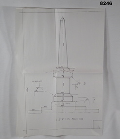 Bendigo Military Museum
Plan - MONUMENT PLANS, C.1992
Plan for Monument in front of the Soldiers Memorial Institute Pall Mall Bendigo, refer Cat No 8245.2.Plan, white paper, all black ink of a proposed Monument, scale 1:100 showing front elevation, plan and section A.A"Proposed Monument to Ex Servicemen and Women to be erected in Pall Mall Bendigo"brsl, smirsl, monument, plan -
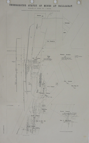 Federation University Historical Collection
Plan, Underground Survey of Mines at Ballarat, 1886, 1886
Plan showing the streets of Ballarat (Sebastopol Street, LaTrobe Street, Drummond Street, Errard Street). Mines include Williams' Freehold, Band of Hope Quartz, Wilson's Freehold, Smith's Freehold, Washington Freehold, Kohinoor No. 2, East Korinoor, Burra Burra No 1, Wareham's, Hawthorne's, Jones', Young Washington, New Kohinoor, Benn's,plan, mining, cgt, williams' freehold, band of hope quartz, wilson's freehold, smith's freehold, washington freehold, kohinoor no. 2, east korinoor, burra burra no 1, wareham's, hawthorne's, jones', young washington, new kohinoor, benn's -
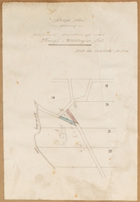 Bacchus Marsh & District Historical Society
Map, Rough plan showing proposed deviation of road through McKenzie's Flat
The date of this map or plan is uncertain. McKenzie's Flat is a bushland picnic area on the Lerderderg River in the Lerderderg State Park close to Bacchus Marsh. Single page map showing a proposed deviation of the road near the McKenzie's Flat area close to Bacchus Marsh. The proposed deviation is shaded in pink, The existing road section to be replaced is shaded in blue. No scale is indicated. Part of a set of maps which are pasted into a bound volume containing 76 maps or plans in total. High resolution digital image stored on BMDHS computer network. mckenzies flat bacchus marsh, bacchus marsh roads and streets