Showing 915 items
matching railway park
-
 Ringwood and District Historical Society
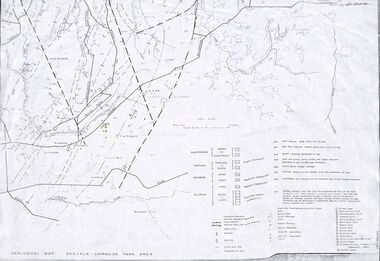
Map - Maps, Geological Map Donvale to Chirnside Park, also Victorian Railways Maps of Hawthorn to Lilydale Line incl Ringwood to East Ringwood - 1881
... . Geological Map Donvale to Chirnside Park, also Victorian Railways ...Faint photocopies of sections of larger maps. Geological map includes location of mine shafts circa 1920.Victory Shaft, North Victory Shaft, South Caledonia Shaft, Caledonia Shaft, North Caledonia Shaft, Black Swan Shaft, Reward Shaft, Consols Shaft, Blocks Shaft, Devonshire Shaft, Crown Shaft, Yarra Tunnel Reef Working, Bright's Shaft, Kingwood Antimony Company Shaft (Boardman's Shaft), Southern Shaft. -
 Ringwood and District Historical Society
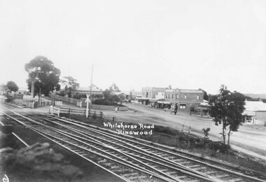
Photograph, Maroondah Highway Central, Ringwood. Main St, looking west showing old railway crossing and station masters home in centre - 1918
Black and white photograph (2 copies)Typed below one copy: "Main St. Looking west showing old railway crossing and station masters home in centre - 1918". Typed below other copy: "Maroondah Highway looking west c1918. Showing old railway level crossing at left. Station masters residence in centre. Shops to right now Eastland car park." -
 Orbost & District Historical Society
black and white photograph, February 1971
This photograph was taken near the Snowy River Bridge on the the old Princes Highway in Orbost, near the caravan park. The 1971 flood was the the worst flood on record. At Jarrahmond it was at least 11 metres and up to one and a half kilometres wide on the flats causing enormous damage to the flood plain. Records say that "The brown floodwater stain in Bass Strait could be seen from passing airliners." Considerable damage was done to railway infrastructure, roads and farms. More information from the APRIL, 2008 newsletter by John Phillips. (see orbosthistory.com.au)This is pictorial evidence of a significant local event. Floods have been an integral part of Orbost's history for hundreds of years.A black / white photograph of debris, fallen power lines, a tree across the highway and floodwaters across the road.on front at bottom - handwritten in upper case print - " 1971 FLOOD PRINCES HIGHWAY NEAR SNOWY BRIDGE"floods-orbost-1971 -
 Ringwood and District Historical Society
Flyer, Stillwell & Stephens Pty. Ltd, Brochure - Multiple Properties for Public Auction at Box Hill, Ringwood, Wonga Park and Clarinda - 28th November, 1934
Seven-page brochure advertising Mortgagees' Realising Sale by Public Auction on Wednesday, 28th November, 1934 for properties at Box Hill, Ringwood, Wonga Park, and Clarinda (via Oakleigh), including photographs, property descriptions, and terms of sale.Auction Commencing at 2.15 p.m. in the Orient Line Auction Rooms, 352 Collins Street, Melbourne. Solicitors: Messrs. Madden, Butler, Elder & Graham, 406 Collins Street, Melbourne. (Agents) H.P. Knight & Co. Property Salesmen and Subidivisional Experts, 315 Collins Street, Melbourne, 'Phones: Central 10615, 10616. Attractive Residential, Orchard, and Market Garden Properties, and Public Hall and School Rooms. 1. Wonga Park via Ringwood - "Holme Bush" off Warrandyte Road, Part of Lots 14 and 15, Ringwood Orchard Estate, approximatgely three miles (north) of Ringwood Railway Station - 64 Acres. 2. 17 Bishop Street, Box Hill - timber residence. 3. Greenwood Avenue, Ringwood - On East Side, 150 feet 3 inches South of Bedford Road - timber attic residence. 4. Ringwood - Wantirna Road, South-east corner of Canterbury Road - Orchard Property of approx. 11-1/2 Acres. 5. Box Hill - Whitehorse Road, South-east corner of Linsley Street - Timber building utilised as a Public Hall and Private School. 6. Clarinda vic Oakleigh, Talbot Crescent, off Centre Road - Home on 10 acres of land. -
 Marysville & District Historical Society
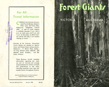
Ephemera (Item) - Information brochure, Victorian Government Tourist Bureau, Forest Giants Victoria Australia, 01-1938
An information brochure on where to see tall trees, Forest Giants, in Victoria, including Marysville, that was published in January, 1938.An information brochure on where to see tall trees, Forest Giants, in Victoria, including Marysville, that was published in January, 1938.Victorian Railways Print January, 1938 469-38 Stamp of Victorian/ Government Tourist Bureau/ 272 Collins Street/ Melbourne C.1victoria, australia, victorian government tourist bureau, betterment and publicity board, victorian railways, white mountain ash, red mountain ash, messmate, blue gum, mountain ash, cumberland valley, marysville, mount monda, healesville, acheron way, alpine highway, omeo, baw baws, strzelecki ranges, otway ranges, warburton, yarra junction, noojee, bulga and tarra valley park, yarram, turton's pass, otway forest, beech forest, apollo bay, information brochure, brochure -
 Eltham District Historical Society Inc
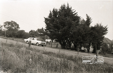
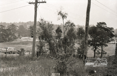
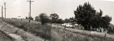
Photograph, Sherbourne Road, Para Road and Simms Road at Briar Hill, 3 November 1967, 3 Nov 1967
Viewed from railway line opposite Graham Body Works. Simms Road is running to the right in front of the old house. The house belongs to Mrs Cameron whose daughter married a DAVEY after which Davey Street is named. Excavation work is being undertaken for the realignment of the Para Road and Sherbourne Road intersection where the current roundabout is located, approximately where the two cars are parked. Mrs Cameron's house and the other are where Montmorency Secondary College is situated. The school opened in 1969.Roll of 35mm black and white negative film, 6 strips Ilford HP3briar hill, cameron, davey, davey road, graham body works, greensborough, montmorency secondary college, sherbourne road, simms road -
 Eltham District Historical Society Inc
Photograph, Sherbourne Road, Para Road and Simms Road at Briar Hill, 3 November 1967, 3 Nov 1967
Viewed from railway line opposite Graham Body Works. Simms Road is running to the right in front of the old house. The house belongs to Mrs Cameron whose daughter married a DAVEY after which Davey Street is named. Excavation work is being undertaken for the realignment of the Para Road and Sherbourne Road intersection where the current roundabout is located, approximately where the two cars are parked. Mrs Cameron's house and the other are where Montmorency Secondary College is situated. The school opened in 1969.Photostitch from multiple images on roll of film. Roll of 35mm black and white negative film, 6 strips Ilford HP3briar hill, cameron, davey, davey road, graham body works, greensborough, montmorency secondary college, sherbourne road, simms road -
 Eltham District Historical Society Inc
Photograph, Peter Bassett-Smith, Upper Yarra Dam, Spring Tour, 22 Oct 1995, 22/10/1995
EXPLORING THE UPPER YARRA (Newsletter No. 105, November 1995, by Bettina Woodburn) We enjoyed the Spring Excursion, this year "Exploring the Upper Yarra" - in spite of the constant rain and the countryside under the cloud cover, especially in the valleys, being mainly shiny shades of green. The occasional fields of buttercups, clumps of arum lilies and splendid rhododendron and other flowering bushes became very special. The Cobb and Co coach was warm and a cosy retreat as we zig-zagged on the highways and byways to glimpse the Yarra River, upstream and down, its secret places, and particularly the many bridges. Russell excelled as 'Poet Laureate', reading from Dacre Smyth's book. This 1979 publication includes paintings of all the bridges along the river with poems and brief descriptions of each one. Some of the bridges are in out of the way places and are not very well known. We looked forward to hearing the poetry as much as seeing the ' constructions'…Big Pat (was he short or tall, lean or fat? He did win the two hundred pound reward for discovering gold and had the creek named after him), about the 'Eddies'?, and the disliked 'meccano' bridge in Warburton, etc. etc. The hot roast lunch in the old Reefton Hotel was also most welcome. It was easy to imagine it peopled by miners and early settlers. Starting by crossing the new (1974) concrete bridge at Warrandyte we headed through Wonga Park with views to the Christmas Hills and to the escarpment of the Yering Gorge, which causes flood waters to back up through the Yarra Glen plain, so avoiding disasters downstream. At the end of a long driveway we found the wooden, privately owned Henley Bridge (1935 after the 1934 floods). This facilitates access to different parts of Henley Farm and to Lilydale. Everard Park, named after Blanche Shallard's father, a State Member for 17 years, below the Highway Yarra crossing was in need of care. It is 10 miles from Yarra Glen by road but, as "Yarra Marra” canoeists well know, 32 winding miles down by water. After more delightful countryside scenes we joined the Warburton Highway at Woori Yallock. From the old Railway Station at Launching Place the Centennial Trail for walkers, cyclists and ' horse riders has replaced the rails. The line from Lilydale was opened in 1901, and the last diesel freight train ran to Warburton in 1965. It continued to rain as we had morning tea in Warburton in a shelter between footbridges. From here we continued upstream past the Bridge to O'Shannasy Lodge and Reservoir, Starvation Creek, and the Peninsular tunnel (miners dug it as at Pound Bend) which we visited (scrambling down those steps!) on our return after lunch. Our furthermost point was the Upper Yarra Dam Reserve (and vast catchment area). Finished in 1957 after ten years work and 100 years after Yan Yean, it supplies much of Melbourne's water. After crossing the 30m Launching Place Bridge to the Eltham side of the Yarra and Healesville, we saw in the distance the Yarra Glen Timber Trestle Bridge over the river flats "the longest for years in the land it was said!" Harry's dream of "better weather over the Divide" unfortunately didn't come true, but I'm sure we 36 members will retain happy memories of a day that was wet and green and filled with Bridges. Bettina Woodburn - October 1995 Record of the Society's history of activities - Spring 1995 excursionColour photographactivities, upper yarra dam, 1995, peter bassett-smith -
 Eltham District Historical Society Inc
Photograph, Peter Bassett-Smith, Upper Yarra Dam, Spring Tour, 22 Oct 1995, 22/10/1995
EXPLORING THE UPPER YARRA (Newsletter No. 105, November 1995, by Bettina Woodburn) We enjoyed the Spring Excursion, this year "Exploring the Upper Yarra" - in spite of the constant rain and the countryside under the cloud cover, especially in the valleys, being mainly shiny shades of green. The occasional fields of buttercups, clumps of arum lilies and splendid rhododendron and other flowering bushes became very special. The Cobb and Co coach was warm and a cosy retreat as we zig-zagged on the highways and byways to glimpse the Yarra River, upstream and down, its secret places, and particularly the many bridges. Russell excelled as 'Poet Laureate', reading from Dacre Smyth's book. This 1979 publication includes paintings of all the bridges along the river with poems and brief descriptions of each one. Some of the bridges are in out of the way places and are not very well known. We looked forward to hearing the poetry as much as seeing the ' constructions'…Big Pat (was he short or tall, lean or fat? He did win the two hundred pound reward for discovering gold and had the creek named after him), about the 'Eddies'?, and the disliked 'meccano' bridge in Warburton, etc. etc. The hot roast lunch in the old Reefton Hotel was also most welcome. It was easy to imagine it peopled by miners and early settlers. Starting by crossing the new (1974) concrete bridge at Warrandyte we headed through Wonga Park with views to the Christmas Hills and to the escarpment of the Yering Gorge, which causes flood waters to back up through the Yarra Glen plain, so avoiding disasters downstream. At the end of a long driveway we found the wooden, privately owned Henley Bridge (1935 after the 1934 floods). This facilitates access to different parts of Henley Farm and to Lilydale. Everard Park, named after Blanche Shallard's father, a State Member for 17 years, below the Highway Yarra crossing was in need of care. It is 10 miles from Yarra Glen by road but, as "Yarra Marra” canoeists well know, 32 winding miles down by water. After more delightful countryside scenes we joined the Warburton Highway at Woori Yallock. From the old Railway Station at Launching Place the Centennial Trail for walkers, cyclists and ' horse riders has replaced the rails. The line from Lilydale was opened in 1901, and the last diesel freight train ran to Warburton in 1965. It continued to rain as we had morning tea in Warburton in a shelter between footbridges. From here we continued upstream past the Bridge to O'Shannasy Lodge and Reservoir, Starvation Creek, and the Peninsular tunnel (miners dug it as at Pound Bend) which we visited (scrambling down those steps!) on our return after lunch. Our furthermost point was the Upper Yarra Dam Reserve (and vast catchment area). Finished in 1957 after ten years work and 100 years after Yan Yean, it supplies much of Melbourne's water. After crossing the 30m Launching Place Bridge to the Eltham side of the Yarra and Healesville, we saw in the distance the Yarra Glen Timber Trestle Bridge over the river flats "the longest for years in the land it was said!" Harry's dream of "better weather over the Divide" unfortunately didn't come true, but I'm sure we 36 members will retain happy memories of a day that was wet and green and filled with Bridges. Bettina Woodburn - October 1995 Record of the Society's history of activities - Spring 1995 excursionColour photographactivities, upper yarra dam, 1995 -
 Eltham District Historical Society Inc
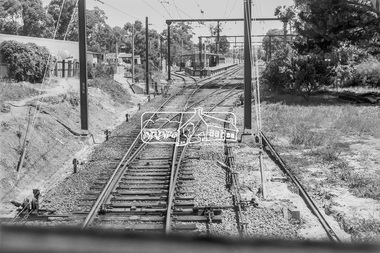
Photograph, George Coop, Approaching Eltham Railway Station from Diamond Creek, 6 December 1980, 1980
View from driver's cabin The Station Master's house is located within the cluster of trees to the left of the photograph which is now the short term car park and bus bay. The Country Art Store is now Cafe 3095.Digital TIFF file Scan of 35mm Ilford FP4 black and white transparencycountry art store, eltham railway station, eltham station masters house -
 Eltham District Historical Society Inc
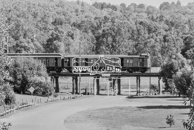
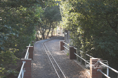
Photograph, George Coop, A Tait (Red Rattler ) train crosses the Eltham Railway Trestle Bridge at Panther Place, Eltham, 7-8 February 1981, 1981
Eltham Central Park viewed through the bridgeDigital TIFF file Scan of 35mm Ilford FP4 black and white transparency435m, eltham central park, eltham trestle bridge, hurstbridge line, panther place, red rattler, tait train -
 Eltham District Historical Society Inc
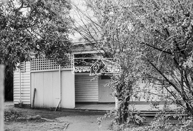
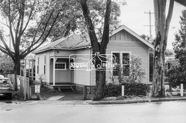
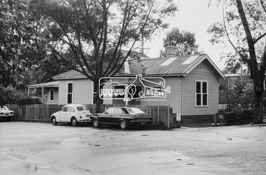
Photograph, George Coop, Station Master's House, Eltham Railway Station, 21 August 1983, 1983
The Station Master's house was situated in what is now the short term car park and bus bay. It was sold for $1 and relocated to Park West Road and renovated.Digital TIFF file Scan of 35mm Kodak Safety 5062 black and white transparencyeltham railway station, eltham station masters house -
 Eltham District Historical Society Inc
Photograph, Fred Mitchell, Diamond Valley Railway, 24 February 2006, 24/02/2006
... melbourne fred mitchell collection 2006 eltham lower park diamond ...Digital copy of colour photographfred mitchell collection, 2006, eltham lower park, diamond valley railway -
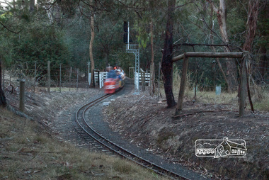
 Eltham District Historical Society Inc
Photograph, Fred Mitchell, Special night run event, Diamond Valley Railway, 12 March 2006, 12/03/2006
... melbourne fred mitchell collection 2006 eltham lower park diamond ...Digital copy of colour photographfred mitchell collection, 2006, eltham lower park, diamond valley railway -
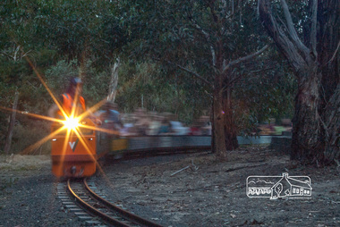
 Eltham District Historical Society Inc
Photograph, Fred Mitchell, Special night run event, Diamond Valley Railway, 12 March 2006, 12/03/2006
... melbourne fred mitchell collection 2006 eltham lower park diamond ...Digital copy of colour photographfred mitchell collection, 2006, eltham lower park, diamond valley railway -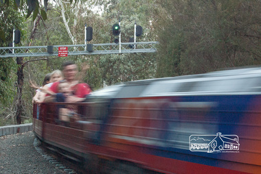
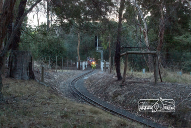
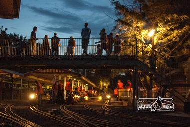
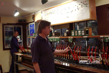 Eltham District Historical Society Inc
Photograph, The Signal Box during a special night run event, Diamond Valley Railway, 12 March 2006, 12/03/2006
... melbourne fred mitchell collection 2006 eltham lower park diamond ...Digital copy of colour photographfred mitchell collection, 2006, eltham lower park, diamond valley railway, signal box -
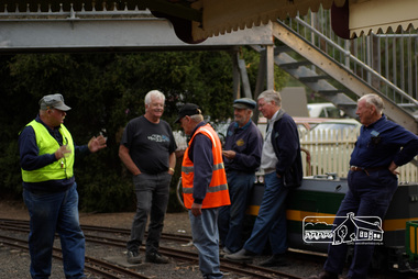 Eltham District Historical Society Inc
Photograph, Special night run event, Diamond Valley Railway, 11 March 2007, 12/03/2006
... melbourne fred mitchell collection eltham lower park diamond valley ...Digital copy of colour photographfred mitchell collection, eltham lower park, diamond valley railway