Showing 519 items
matching architects plans
-
 Kew Historical Society Inc
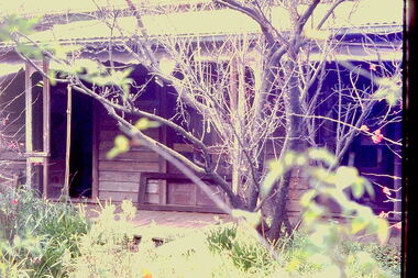
Slide - 'Reno', St John 's Parade, 1977
‘Reno’, stood on the east side of St John’s Parade. Its earliest recorded owner was the architect Samuel Cocking who lived there from c.1865 until his death in 1888. The original landholding was bordered by Cotham Road, Glenferrie Road, Wellington Street, and Charles Street. The southern portion of this land included a fine orchard, with many imported trees. The old summer house, at first in the orchard, was later removed to the house garden. The MMBW Detail Plan No.1576 (1904) shows the remaining portion of the original land holding, including a semi-circular pathway at the front, and garden features such as an aviary, a fountain and grotto, and a fernery. The garden including rare plants supplied by Baron Von Mueller, surrounds the cottage in a tangled frenzy. Despite a ‘local significance’ classification by the National Trust, the house was demolished in 1977.Rare photograph of an historically important weatherboard cottage in St John's Parade.Colour positive transparency (slide) of the a doorway of 'Reno' in St John's Parade, Kew (demolished 1977). historic houses -- kew (vic.), reno -- st john's parade -- kew (vic.) -
 Kew Historical Society Inc
Slide - 'Reno', St John 's Parade, 1977
‘Reno’, stood on the east side of St John’s Parade. Its earliest recorded owner was the architect Samuel Cocking who lived there from c.1865 until his death in 1888. The original landholding was bordered by Cotham Road, Glenferrie Road, Wellington Street, and Charles Street. The southern portion of this land included a fine orchard, with many imported trees. The old summer house, at first in the orchard, was later removed to the house garden. The MMBW Detail Plan No.1576 (1904) shows the remaining portion of the original land holding, including a semi-circular pathway at the front, and garden features such as an aviary, a fountain and grotto, and a fernery. The garden including rare plants supplied by Baron Von Mueller, surrounds the cottage in a tangled frenzy. Despite a ‘local significance’ classification by the National Trust, the house was demolished in 1977.Rare photograph of an historically important weatherboard cottage in St John's Parade.Colour positive transparency (slide) of the verandah of 'Reno' in St John's Parade, Kew (demolished 1977). historic houses -- kew (vic.), reno -- st john's parade -- kew (vic.) -
 Kew Historical Society Inc
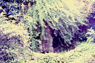
Slide - Grotto of 'Reno', St John 's Parade, 1977
‘Reno’, stood on the east side of St John’s Parade. Its earliest recorded owner was the architect Samuel Cocking who lived there from c.1865 until his death in 1888. The original landholding was bordered by Cotham Road, Glenferrie Road, Wellington Street, and Charles Street. The southern portion of this land included a fine orchard, with many imported trees. The old summer house, at first in the orchard, was later removed to the house garden. The MMBW Detail Plan No.1576 (1904) shows the remaining portion of the original land holding, including a semi-circular pathway at the front, and garden features such as an aviary, a fountain and grotto, and a fernery. The garden including rare plants supplied by Baron Von Mueller, surrounds the cottage in a tangled frenzy. Despite a ‘local significance’ classification by the National Trust, the house was demolished in 1977.Rare photograph of an historically important weatherboard cottage in St John's Parade.Colour positive transparency (slide) of the grotto in the garden of 'Reno' in St John's Parade, Kew (demolished 1977). historic houses -- kew (vic.), reno -- st john's parade -- kew (vic.) -
 Kew Historical Society Inc
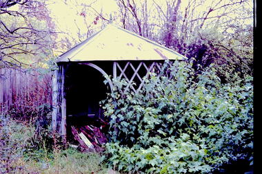
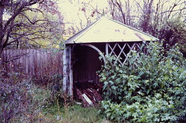
Slide - Former Summerhouse in the Garden of 'Reno', St John 's Parade, 1977
‘Reno’, stood on the east side of St John’s Parade. Its earliest recorded owner was the architect Samuel Cocking who lived there from c.1865 until his death in 1888. The original landholding was bordered by Cotham Road, Glenferrie Road, Wellington Street, and Charles Street. The southern portion of this land included a fine orchard, with many imported trees. The old summer house, at first in the orchard, was later removed to the house garden. The MMBW Detail Plan No.1576 (1904) shows the remaining portion of the original land holding, including a semi-circular pathway at the front, and garden features such as an aviary, a fountain and grotto, and a fernery. The garden including rare plants supplied by Baron Von Mueller, surrounds the cottage in a tangled frenzy. Despite a ‘local significance’ classification by the National Trust, the house was demolished in 1977.Rare photograph of an historically important weatherboard cottage in St John's Parade.Colour positive transparency (slide) of the former summerhouse in the garden of 'Reno' in St John's Parade, Kew (demolished 1977). historic houses -- kew (vic.), reno -- st john's parade -- kew (vic.) -
 Kew Historical Society Inc
Slide - 'Reno', St John 's Parade, 1977
‘Reno’, stood on the east side of St John’s Parade. Its earliest recorded owner was the architect Samuel Cocking who lived there from c.1865 until his death in 1888. The original landholding was bordered by Cotham Road, Glenferrie Road, Wellington Street, and Charles Street. The southern portion of this land included a fine orchard, with many imported trees. The old summer house, at first in the orchard, was later removed to the house garden. The MMBW Detail Plan No.1576 (1904) shows the remaining portion of the original land holding, including a semi-circular pathway at the front, and garden features such as an aviary, a fountain and grotto, and a fernery. The garden including rare plants supplied by Baron Von Mueller, surrounds the cottage in a tangled frenzy. Despite a ‘local significance’ classification by the National Trust, the house was demolished in 1977.Rare photograph of an historically important weatherboard cottage in St John's Parade.Colour positive transparency (slide) of the garden of 'Reno' in St John's Parade, Kew (demolished 1977). historic houses -- kew (vic.), reno -- st john's parade -- kew (vic.) -
 Kew Historical Society Inc
Slide - Former Summerhouse in the Garden of 'Reno', St John 's Parade, 1977
‘Reno’, stood on the east side of St John’s Parade. Its earliest recorded owner was the architect Samuel Cocking who lived there from c.1865 until his death in 1888. The original landholding was bordered by Cotham Road, Glenferrie Road, Wellington Street, and Charles Street. The southern portion of this land included a fine orchard, with many imported trees. The old summer house, at first in the orchard, was later removed to the house garden. The MMBW Detail Plan No.1576 (1904) shows the remaining portion of the original land holding, including a semi-circular pathway at the front, and garden features such as an aviary, a fountain and grotto, and a fernery. The garden including rare plants supplied by Baron Von Mueller, surrounds the cottage in a tangled frenzy. Despite a ‘local significance’ classification by the National Trust, the house was demolished in 1977.Rare photograph of an historically important weatherboard cottage in St John's Parade.Colour positive transparency (slide) of the former summerhouse in the garden of 'Reno' in St John's Parade, Kew (demolished 1977). historic houses -- kew (vic.), reno -- st john's parade -- kew (vic.) -
 Kew Historical Society Inc
Slide - Derham House (formerly 'Mount View), 8 Selbourne Road, 1979
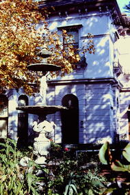
One of a group of slides taken by members of the Society of built heritage in Kew in 1979-80. The selection of subject matter reflects the priorities of the period. The colour of some slides has degraded.The slides represent a snapshot in time of built architecture in Kew, much of which has changed in the forty-plus period since they were created.Colour positive transparency (slide) of the the fountain and garden of Derham House, formerly 'Mount View', 8 Selbourne Road, Kew. The house wa designed in 1888 by the architect Frederick de Garis as his home. Prue Sanderson, 'Kew Conservation Study: Vol.II" wrote about Mount View that: "The house is typical of the late Victorian period in it being clad in render and styled in the Italianate. It has an asymmetrical composition with polygon bay windows extending up both floors, to each of the main facades. The ground floor is heavily incised with banded rustication, while the first floor is distinguished by the cast iron balconettes to each window. The fountain and pond in the garden appear to be those depicted in the 1903 MMBW plan of the property.""Fountain Ruyton in front of Derham House"historic houses -- kew (vic.), ruyton girls' school, derham house, mount view, italianate architecture, fountains -
 Kew Historical Society Inc
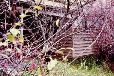
Photograph - 'Reno', 10 St John's Parade, John T Collins, 1977
‘Reno’, stood on the east side of St John’s Parade. Its earliest recorded owner was the architect Samuel Cocking who lived there from c.1865 until his death in 1888. The original landholding was bordered by Cotham Road, Glenferrie Road, Wellington Street, and Charles Street. The southern portion of this land included a fine orchard, with many imported trees. The old summer house, at first in the orchard, was later removed to the house garden. The MMBW Detail Plan No.1576 (1904) shows the remaining portion of the original land holding, including a semi-circular pathway at the front, and garden features such as an aviary, a fountain and grotto, and a fernery. The garden including rare plants supplied by Baron Von Mueller, surrounds the cottage in a tangled frenzy. Despite a ‘local significance’ classification by the National Trust, the house was demolished in 1977.Partial view, north side of the weatherboard cottage in St John's Parade, Kew, known as 'Reno' (demolished 1977). Architectural elements revealed in this photo by John T Collins include: two wing, hip roof construction; external buildings at angles to main wing; corrugated iron roofing [over shingles]; brick chimney external to building; unvarnished/unpainted external weatherboards. General dilapidated condition. "Kew 'Reno' 10 St Johns Pde / John Collins, 11 Anderson Road, Hawthorn East, 3123, Film 35B Exposure 27"reno - st john's parade -- kew (vic.), john t collins -
 Kew Historical Society Inc
Photograph - 'Reno', 10 St John's Parade, John T Collins, 1977
‘Reno’, stood on the east side of St John’s Parade. Its earliest recorded owner was the architect Samuel Cocking who lived there from c.1865 until his death in 1888. The original landholding was bordered by Cotham Road, Glenferrie Road, Wellington Street, and Charles Street. The southern portion of this land included a fine orchard, with many imported trees. The old summer house, at first in the orchard, was later removed to the house garden. The MMBW Detail Plan No.1576 (1904) shows the remaining portion of the original land holding, including a semi-circular pathway at the front, and garden features such as an aviary, a fountain and grotto, and a fernery. The garden including rare plants supplied by Baron Von Mueller, surrounds the cottage in a tangled frenzy. Despite a ‘local significance’ classification by the National Trust, the house was demolished in 1977.Partial view, side of the weatherboard cottage in St John's Parade, Kew, known as 'Reno' (demolished 1977). Architectural elements revealed in this photo by John T Collins include: hip roof construction; corrugated iron roofing [over shingles]; unvarnished/unpainted external weatherboards; Externally opening 1860s-style casement window. General dilapidated condition. "Kew 'Reno' 10 St Johns Pde / John Collins, 11 Anderson Road, Hawthorn East, 3123, Film 35B Exposure 26"reno - st john's parade -- kew (vic.), john t collins -
 Kew Historical Society Inc
Photograph - 'Reno', 10 St John's Parade, John T Collins, 1977
‘Reno’, stood on the east side of St John’s Parade. Its earliest recorded owner was the architect Samuel Cocking who lived there from c.1865 until his death in 1888. The original landholding was bordered by Cotham Road, Glenferrie Road, Wellington Street, and Charles Street. The southern portion of this land included a fine orchard, with many imported trees. The old summer house, at first in the orchard, was later removed to the house garden. The MMBW Detail Plan No.1576 (1904) shows the remaining portion of the original land holding, including a semi-circular pathway at the front, and garden features such as an aviary, a fountain and grotto, and a fernery. The garden including rare plants supplied by Baron Von Mueller, surrounds the cottage in a tangled frenzy. Despite a ‘local significance’ classification by the National Trust, the house was demolished in 1977.Side of the original, relocated summer house of 'Reno' at 10 St John's Parade, Kew, (demolished 1977). Architectural elements revealed in this photo by John T Collins include: four-sided construction; trellis and weatherboard walls; corrugated iron roofing. Re-use as woodshed. General dilapidated condition. "Kew 'Reno' 10 St Johns Pde / John Collins, 11 Anderson Road, Hawthorn East, 3123, Film 35B Exposure 24"reno - st john's parade -- kew (vic.), john t collins -
 Kew Historical Society Inc
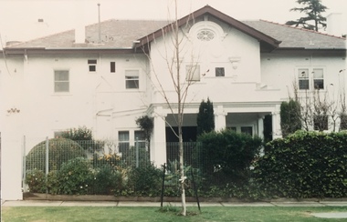
Photograph - Cluny Convent (formerly 'Fairview'), 34 Wrixon Street, 1988
Frederick J. Robinson, a manufacturer, was the owner and occupier of a nine-roomed brick house by at least 1934. At that date the N.A.V. for the property was £270 while in the following year the N.A.V. increased to £350 with a note of 'additions' being made, recorded in the Rate Books. By December 1936 Robinson's house was being described as having twelve rooms and an N.A.V. of £295. The works were undertaken for Robinson by the leadng architect, Harold Desbrowe Annear, and appear to have been a comprehensive remodelling of the Victorian house on the site, the outline of which was clearly depicted in the MMBW plan of 1903. 'Fairview' is of significance as a comprehensive remodelling of a Vietorian house undertaken in the 1930s by the leading architect of the time, Harold Desbrowe Annear. The 1930s are integral to the significance of the whole. (Kew Conservation Study, 1988)Colour photographic positive of Cluny Convent (formerly 'Fairview') remodelled by the architect Harold Desbrowe Annear in the mid 1930s. cluny convent -- kew (vic.), fairview -- 34 wrixon street -- kew (vic.), harold desbrowe annear -
 Kew Historical Society Inc
Photograph - Kew War Memorial, 1927
The Kew War Memorial was planned and constructed at the apex of Cotham Road and High Street, Kew. It was built to commemorate those soldiers from Kew who served in the First World War. The Memorial was designed by the architect Harry Tompkins. It was unveiled by the Governor of Victoria in 1925.An early photograph of this iconic Memorial that locates it in its context. Small black and white photographic positive showing the Kew War Memorial in 1927, two years after its opening. The shops, known then as 'The Block' can be seen behind the Memorial.Annotated verso "Kew Memorial"kew war memorial, war memorials -- kew -- victoria -- australia, architects - harold tompkins, cotham road, high street -- kew (vic.), wwi -
 National Wool Museum
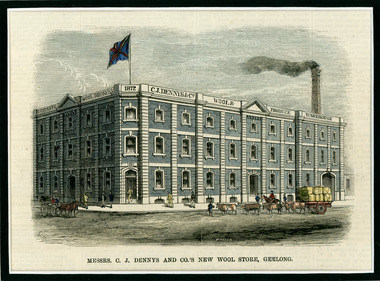
Newspaper Cutting, Messrs. C. J. Dennys and Co.'s New Wool Store Geelong, 10/9/1872
The Denny Lascelles Wool Warehouse was the first building in Victorian planned to facilitate storage, inspection and marketing of wool in one operation, and upon completion was the second largest store in the colony. CJ Denny's was largely responsible for establishment and development of the wool marketing industry in Geelong and is a figure of significance in the history of settlement in Geelong. The wool store, a basalt structure with cement rendered ornamentation, was erected for CJ Denny's and Co, in 1872 to the design of Jacob Pitman, Architect.Wood cut engraving of the Mesrs. C. J. Dennys and Co.'s New Wool Store Geelong, published in The Illustrated Australian News, 1872. The half page full colour illustration shows the newly constructed Wool Store with a bull drawn cart carrying full wool bales situated out the front of the store.Top margin: THE ILLUSTRATED AUSTRALIAN NEWS 201 Below image: Mesrs. C. J. Dennys and Co.'s New Wool Store Geelong Image signed, lower mid edge: WINSTON Image, on building: C.J. Dennys Wool Brokers 1872 C.J. Dennys & Co. Wool & Produce Warehousedenny lascelles wool warehouse, wool, dennys, wool store -
 Vision Australia
Plan - Image, RAAF HQ Royal Victorian Institute for the Blind, 14/3/1942
In 1942, the expansion of the war into the Pacific expanded wartime operations in Australia and some of the RVIB buildings were comandeered for house military staff. This plan, drawn up in March 1942 by J.G. and authorised by the Superintending Architect and (W. Dale)Works Director Air Services show the layout of the main building at 557 St Kilda Road as well as that of the babies nursery. Doorways, cupboards and stairwells are annotated in this carbon copy, as well as the layout of Ormond Hall.1 architectural plan of St Kilda Road layoutmyer house, royal victorian institute for the blind, plans, raaf -
 Vision Australia
Plan - Image, Conversion to Administrative offices / Conversion to Rehabilitation centre, 1 November 1962 - 5 April 1963
... for the Blind Plans John F D Scarborough and Partners, Architects 7 ...Over 1962-63, plans were drawn up for the conversion of the main building into administrative offices and a rehabilitation centre. As the children were now located at the school in Burwood, and with funds achieved from the sale of the old factory buildings to the Alfred Hospital, the St Kilda Road building could expand room for its office workers and provide greater floor space to rehabilitation staff. These plans show the proposed conversion from bedrooms to administrative and rehabilitation areas.7 architectural plans and 1 letterJohn F D Scarborough and Partners, Architectsroyal victorian institute for the blind, plans -
 Vision Australia
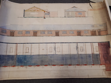
Plan - Image, New verandah & draining to court for the Royal Victorian Institute for Blind, April 1924
... for the blind plans Stephenson & Meldrum, Architects Collins Court 374 ...In 1924 plans were submitted to the RVIB board for the addition of a new veranda and associated drainage pipes located in the courtyard behind Ormond Hall. Hand written notes on the plan indicate that the tender for materials from Pollards was 330 pounds, asphalt 35 pounds totally a cost of 365 pounds. And that additional costs of 120 pounds, comprising of 20 for G Lavatory (?) and J Famdy (?) 100 pounds.1 architectural plans for proposed verandah and drainageStephenson & Meldrum, Architects Collins Court 374 Little Collins Street Melbourne Phone: 6990royal victorian institute for the blind, plans -
 Vision Australia
Plan - Image, Royal Victorian Institute for the Blind Extension to Bulk Store, 27/8/1925 (according to Mosiac entry)
... includes a floor plan of these areas. Noted on the plan ...In this undated drawing, believed to have been done in 1925, an existing bluestone store was extended out into the courtyard area. The extensions were on the south and west elevations, and the drawing includes a floor plan of these areas. Noted on the plan is the removal of fireplaces that existed in this building, the location abutting the Alfred Hospital reserve and location of the motor room.1 architectural plan of extension to bulk storeStephenson & Meldrum, Architects 374 Little Collins Street Melbourne Phone: 6990 On the back: Widening of old bluestone store plans & specroyal victorian institute for the blind, plans -
 Vision Australia
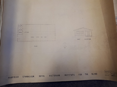
Plan - Image, Proposed Gymnasium Royal Victorian Institute for the Blind, 21 June 1950
... Everett Chief Architect 2 architectural plans showing proposed ...In 1951 plans were made for the construction of a gymnasium to be situated in the grounds of St Kilda Road. These 4 plans specify the building construction notes, present front and east elevations, and show how part of the hall could be transformed into bedrooms in the future. There are 2 copies of each plan, consisting of identifical copies of the east elevation and different notes printed/handwritten on the front, side and top elevations. These were presented to the RVIB Board in Feburary 1951, according to the stamp on the back.2 architectural plans showing proposed gymnasium buildingPercy E Everett Chief Architectroyal victorian institute for the blind, plans -
 Vision Australia
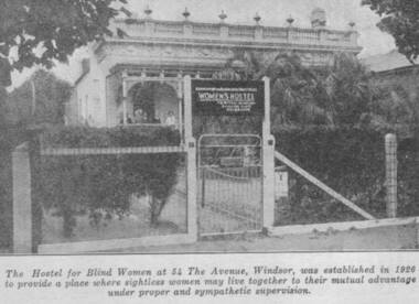
Photograph - Image, Women's Hostel (Egremont) in Windsor newspaper cutting
The AFB were aware that accommodation options for blind people were limited and sought to open a hostel to assist with this.The first hostel opened in Lara Street, South Yarra but could not meet demand. In 1926, a suitable property 'Egremont' at 54 The Avenue, Windsor, came on the market. The price was £2650. Lack of funds to purchase seemed an insurmountable barrier. With assistance from the Trustees of the Edward Wilson Estate and the Felton Bequest a deposit of £650 was raised. In a huge step of faith the Committee took out a mortgage of £2000. The interest on the mortgage and its repayments weighed heavily on the Committee. The Avenue, as 'Egremont' was commonly termed, was also a seven roomed house. Mr Paterson and the Architect, Mr Parkes of Oakley and Parkes, immediately began planning an extension, fourteen single bedrooms were added. They were filled from the Waiting List. A Windsor Auxiliary was formed and worked to reduce the mortgage of £2000. An active programme of dances, card evenings, theatre nights and the like took place under the leadership of Mrs. Robertson. The Auxiliary also took an interest in the boarders, arranging entertainment and social activity. £1500. was still owed in 1930. Living side by side is no easy task for a group of people, and the Hostel meeting minute books are filled with stories of disputes over wireless sets, telephones, hot water bottles and wardrobes. In 1958, with rising costs and the growth of aged care centres, the Hostel was closed and the house sold to a succession of private buyers. In 2016 it still stands and has been refurbished as a guest house.B/W copy of newspaper photographThe hostel for blind women at 54 The Avenue, Windsor was established in 1926 to provide a place where sightless women may live together to their mutual advantage under proper and sympathetic supervision. The Windsor Hostel was sold in 1958. This building still stands today and has been refurbished.egremont, blind womens hostel, tilly aston -
 Port Fairy Historical Society Museum and Archives
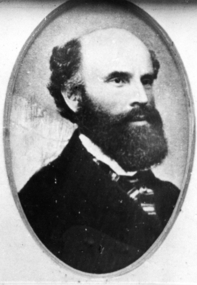
Photograph, Billing, Nathanial
... of Australasia, and worked on St Patricks Catholic church from plans... Catholic church from plans by English architect Hansom. He died ...Nathanial Billing was born in Brightwell Oxfordshire England on 5th May 1821. He emigrated to Australia on the ship 'Ballarat' in 1853 on arrival in Victoria he entered Government service and worked in the Warrnambool and Belfast districts until 1857. He then left the Public Service and commenced private practice. In 1850 Nathaniel and Henrietta Heybourne were married on July 17 at Hillingdon Parish, Middlesex, England. In Belfast Victoria he designed St Johns Church of England, the Bank of Australasia, and worked on St Patricks Catholic church from plans by English architect Hansom. He died on January 29 1910 in St Kilda, Victoria, Australia. Architect of 3 significant public buildings in Belfast/Port FairyBlack and white portrait of gentleman with black full beard and striped cravatpioneer, settler, portrait, people, architect, st johns church of england,, st patricks catholic church, bank of australasia, nathanial billing -
 University of Melbourne, Burnley Campus Archives
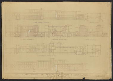
Plan, New School of Primary Agriculture & Horticulture: Burnley Gardens, 1945
Original and photocopy of detailed architectural drawing and plan of new school by the Department of Public Works, Victoria Chief Architect, P. Everett.burnley school of horticulture, burnley gardens, percy everett -
 University of Melbourne, Burnley Campus Archives
Plan, Hilda Marriott ( Dance), Garden Plans by Hilda Marriott (Dance), 1947-1981
Set of 8 plans, including blue-prints, of various gardens, dated c. 1947 - 1981. See paper catalogue for complete list.Plans by Hilda Marriott Dance (1) Sketch plan and 2 blueprint copies of School of Horticulture Burnley. Garden Alterations New Building Area, Working Drawing by H. Dance, Scale ⅟₂₀"=1', 2/4/47, on reverse handwritten,"Proposed Garden Lay-out for New School Building (H. Dance-plan)." (NB Emily Gibson was also involved in the planning of this site.) (2) Tracing paper, paper and blueprint copies of Ararat & District Hospital Garden Plan - MacDonald Memorial & Court, Landscape Architect - H. Dance, Scale 1 inch=8 feet. Includes handwritten note, "Replacement for Ararat Hospital Nov. 1979," list of plants. (3) Blueprint Proposed Design for Garden Watermill Farm, Newbury for Norman Gadsden Esq., Scale ⅟₄₀"=1 ft. (4) Sketch Plan for Garden, Barcombe, Buangor - January 1981 by Hilda Marriott, Scale - Approximate Only - 1:40. (5) Tracing paper copy of plan of Garden at Plumhill, Templestowe, for Mr. & Mrs. Colin Smith. Hilda Dance, Designer 26/4/47, Scale ⅛"=1'. (6) Blueprint Garden House - Sketch. (7) Tracing paper and paper copies Ararat Medical Centre Courtyard Garden, Landscape Architect - Hilda Marriott, Scale - 1:25, Date 8.5.79. (8) Tracing paper copy National Trust of Australia (Victoria) The Heights, Newtown, Geelong Garden Plan, Scale 1:250, Drawn by - Hilda Marriott, Date 12.10.79.(1): on reverse handwritten,"Proposed Garden Lay-out for New School Building (H. Dance - plan)." (2): Includes handwritten note, "Replacement for Ararat Hospital Nov. 1979," list of plants.hilda marriott ( dance), burnley school of horticulture, students -
 University of Melbourne, Burnley Campus Archives
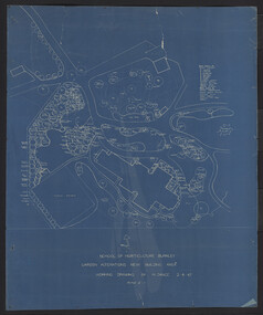
Plan, M. Drake et al, Site Location Plan of Incubator Building and Random Sample Laying Test for Burnley Gardens, 1967
... , Chief Architect. Site Location Plan of Incubator Building ...Plan by Public Works Dept., Melbourne. M. Drake (draughtsman), R. G. Wilson, Chief Architect.m. drake, g.r. wilson -
 University of Melbourne, Burnley Campus Archives
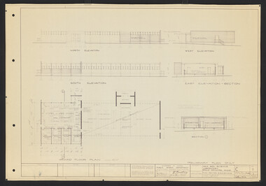
Plan, L.R.B. Simmons, New Soil Science Laboratory, 1973
Plans by Govt. Of Victoria Public Works Dept.: L.R.B. Simmons (Senior Project Architect), D.C. Bradbury (Chief Architect), Drawn by Aldo Bellarmo. A. Proposed addition to existing laboratory. B. Plan of Section and Elevation of proposed new Soil Science laboratory.laboratory, glasshouse, l.r.b. simmons, d.c. bradbury, aldo bellarmo -
 University of Melbourne, Burnley Campus Archives
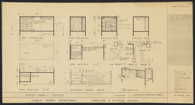
Plan, N.S. Jemmerson, Specifications for Office and Executive Desks, 1961
Plans. A. Specification for Office Desk - Typiste. No. 53. B. Specification for Executive Desk. No. 43. For Ray Davey, Chief Architect, Public Works Dept. Drawn by A: N.S. Jemmerson; B: R.J.G.ray davey, n.s. jemmerson -
 University of Melbourne, Burnley Campus Archives
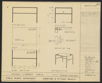
Plan, N.S. Jemmerson, Specification for School Library Table, 1961
Plan. A. No. 47 B. No. 48 for Chief Architect, Ray Davey, Public Works Dept., Furniture & Fittings Branch. Drawn by N.S. Jemmeson.ray davey, n.s. jemmerson -
 University of Melbourne, Burnley Campus Archives
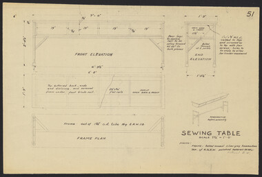
Plan, Sewing Tables, 1958
Plans. A. Sewing Table No. 51 B. Table for Electric Sewing Machines by Chief Architect, Public Works Dept.sewing, tables, machines -
 University of Melbourne, Burnley Campus Archives
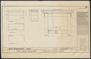
Plan, Home Management Table, 1959
Plan. Specification No. 45 for Home Management Table for Education Dept., High Schools. Drawing No. T:1:11:1 for Public Works Dept., Furniture & Fittings Branch, Chief Architect. Drawn by K.H.furniture -
 University of Melbourne, Burnley Campus Archives
Plan, Percy Everett, Layout Plan of Furniture & Fittings for School of Agriculture & Horticulture at Burnley, 1948
... , Architect. Layout Plan of Furniture & Fittings for School ...Plan for Lecture Rooms 394, Plant Breeders Lab. & Assistant room, Agrostrological Lab. & Office, Demonstrator's Room. By Percy Everett, Architect.laboratory, percy everett