Showing 15878 items
matching areas
-
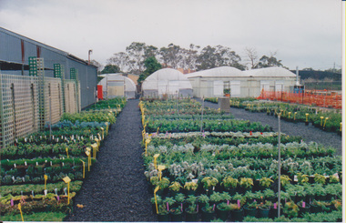 University of Melbourne, Burnley Campus Archives
Photograph - Colour prints, Nursery
Pots in an open area of the Nurserypots, nursery, plants -
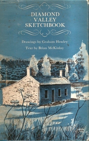 Greensborough Historical Society
Book, Diamond Valley Sketchbook, 1973_
Diamond Valley Sketchbook, written by Brian McKinlay with drawings by Graham Hawley. Cover the area surrounding the Diamond Valley from Heidelberg to Mernda.A sketch book featuring landmarks around the Diamond Valley area in 1973. Many of these no longer exist.A 63 page hard back book with a map of the area covered by the book printed in blue in the inner covers. Three copies have a dust jacket printed in blue with title details, whilst the actual book cover lacks any detail. 4 copies.Some pencil markings in the inside cover.diamond valley, griffin house, rosehill, austin hospital, banyule house, trestle bridge eltham, shillinglaw cottage, montsalvat, old england hotel, eltham primary school, sweeney's cottage, pound bend tunnel, weller's pub, the eltham barrel, hassall's gallery, st katherine's chapel, yan yean reservoir, mernda hotel -
 Warrnambool and District Historical Society Inc.
Booklet, Rhythmns of the Western District, 2003
This is a booklet of four poems about the Warrnambool area written and produced by Iris Fisher. The poems deal with aspects of Warrnambool, Allansford, Port Fairy and Koroit. Iris Fisher wrote the poems when she was living in Allansford. She lived for 18 years in Warrnambool and seven in Allansford and is the author of four other books of verse that tell of her life and thoughts in the Western District of Victoria. This book is of interest as it has been written by Iris Fisher who lived in the Warrnambool area for 25 years. The poems contain many references to the history of the four places – Warrnambool, Port Fairy, Koroit and Allansford. This is a small soft cover booklet of 26 pages. It has a mauve-coloured cover with an image of Childers Cove before the Sentinel rock was washed away. The cover printing is a dark red colour. The booklet contains four printed poems and black and white photographs of scenes and people of the Allansford/Warrnambool area. Mostly the illustrations are of an historic nature. The poems are dedicated to ‘Life in the Warrnambool Area’. The booklet is bound with staples.Front Cover: ‘Rhythmns (sic) of the Western District by Iris Fisher’ Inside front cover: ‘10/7/03 To Graeme and Barbara Best Wishes Iris’ allansford, port fairy, koroit, warrnambool, iris fisher -
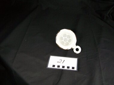 Blacksmith's Cottage and Forge
Strainer, Tea, 1920 (estimated); Approx. 1920
A tea strainer is a type of strainer that is placed over or in a teacup to catch tea leaves. When tea is brewed in the traditional manner in a teapot, the tea leaves are not contained in teabags, but rather are freely suspended in the water. As the leaves themselves may be distasteful, it is usual to filter them out with a tea strainer. Strainers usually fit into the top of the cup to catch the leaves as the tea is poured. Some deeper tea strainers can also be used to brew single cups of tea, much as teabags or brewing baskets are used - the strainer full of leaves is set in a cup to brew the tea, and then removed, along with the spent tea leaves, when the tea is ready to drink. By using a tea strainer in this way, the same leaves can be used to brew multiple cups. Tea strainer use declined in the 20th century with mass production of the tea bag, but is still preferred among connoisseurs who claim that keeping the leaves packed in a bag, rather than freely circulating, inhibits diffusion. Many assert that inferior ingredients, namely dust quality tea, are often used in tea bags. Tea strainers are usually either sterling silver, stainless steel, or china. Strainers often come in a set, with the strainer part and a small saucer for it to sit in between cups. Tea strainers in themselves have often been turned into artistic masterpieces of the silver- and goldsmith's craft, as well as rarer specimens of fine porcelain. Brewing baskets (or infusing baskets) resemble tea strainers, but are more typically put in the top of a teapot to contain the tea leaves during brewing. There is no definitive boundary between a brewing basket and a tea strainer, and the same tool might be used for both purposes. Tea strainers are also used by patients trying to pass a kidney stone. The patient urinates through the strainer, thereby ensuring that, if a stone is passed, it will be caught for evaluation and diagnosis. Source: www.wikipedia.net This item has historical significance in the evolution of Tea drinking.The Strainer being needed if a cup of tea was to be poured without tea leaves being present in the tea liquid.As Tea bags have been introduced into everyday life tea strainers are an item of the past. This particular tea strainer was an item for everyday useage.White enamel tea strainer, round in shape with flange edges, 7 small circle areas of perforations in the concave area of the utensil, a small perforated handle (same material) at one outer area of the item.domestic, kitchen, food, preparation, white, enamel, tea, strainer, beverage, perforated, utensil, round, flanges, leaves -
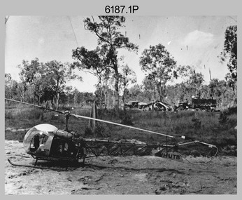 Bendigo Military Museum
Photograph - Bell 47G-2 helicopter used in Royal Australian Survey Corps Field Operations, c1965
This is a set of four photographs of Bell 47G-2 helicopters used in Royal Australian Survey Corps Field Operations. c1965. From 1957, helicopter transport of survey parties revolutionised transport in remote areas. The most common helicopter used by the Royal Australian Survey Corps at this time was the civilian Bell 47G-2 and the Sioux, the Australian Army’s’s equivalent. equivalent. From 1964 an Aerodist MRC2 airborne Electronic Distance Measuring (EDM) system was extensively used for topographic surveys over long distances by trilateration to replace traverse requiring survey station intervisibility. In 1965 the command field survey unit personnel attached to the Army Survey Regiment’s Topographic Squadron were used mainly in support roles such as station clearing, tower operations, station monumenting, Aerodist computations, forward base operations, geodetic observations on the north-south traverse and logistic support for Remote teams. .1P is a photo of a civilian Bell 47G-2 helicopter Registration / Serial VH-UTB owned by Helicopter Utilities from Mascot, NSW c1965. In the background of this photograph is three personnel and vehicles at a field survey camp. The left-hand vehicle is a Willys Jeep with trailer and on the right is probably a Truck, 2 1/2 ton, 6x6, General Service GMC. The Bell 47G-2: VH-UTB was destroyed, and its pilot killed in tragic circumstances during a civilian survey operation on Cape York Peninsula in June 1966. .2P is a photo of a a civilian Bell 47G-2 helicopter Registration / Serial VH-IHB taken in Wyndham, WA. As the letters ‘TAA’ appear on the fuselage, the helicopter was charted from Trans Australian Airways. .3P is a photo of a Bell 47G-2: VH-UTC with survey camp in background. .4P is a photo of a Bell 47G-2 equipped with floats and unidentified personnel loading stores, possibly in Darwin. Acknowledgement: Royal Australian Survey Corps – Aerodist Years 1964-1975 Version 2021.0 Authored by Peter Jensen.This is a set of four photographs of civilian Bell 47G-2 helicopters used in Royal Australian Survey Corps Field Operations. c1965. The photographs were printed on photographic paper and are part of the Army Survey Regiment’s Collection. The photographs were scanned at 300 dpi. .1) - Photo, black & white, c1965, Bell 47G-2 helicopter: VH-UTB with survey camp in background. .2) - Photo, black & white, c1965, Bell 47G-2 helicopter: VH-IHB with survey station in foreground. .3) - Photo, black & white, c1965, Bell 47G-2 helicopter: VH-UTC with survey camp in background. .4) - Photo, black & white, c1965, Bell 47G-2 helicopter: Unidentified personnel loading stores possibly in Darwin..2P – annotated on bottom of photo ‘Wyndham Area – Helicopter drops observing party’ The other photographs are not annotated.royal australian survey corps, rasvy, army survey regiment, army svy regt, fortuna, asr, surveying -
 Bendigo Military Museum
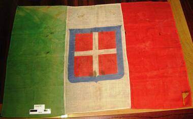
Flag - FLAG, ITALIAN, pre 1946
This design Italian flag dates from 1848 - 1946. This one was taken at Derna in Libya between 10th - 15th November 1942. It was brought home to Australia by Alex ARCHER, No 40637, 3 Sqaudron RAAF. Refer Cat No 2597 for his service details.Italian battle flag made of coarsely woven cotton. Left 1/3 green, right 1/3 red, centre 1/3 white with a centred white cross on red background surounded by a blue shield shaped borderThere are no inscriptions or markings. The centre piece in the white area is the Italian Naval Ensign.flags-military, italian -
 Glenelg Shire Council Cultural Collection
Photograph - Photograph - Henty Beach, Aug-89
Port of Portland Authority ArchivesBack: 'Henty Beach area (Yacht club end) August 89 -
4th/19th Prince of Wales's Light Horse Regiment Unit History Room
Boots, ankle, brown
This pattern boot is very close to that worn by Australian soldiers from WW1 to the 1930'sThe boots are very close in appearance to Australian Army Boots of the WW1 period even though it is doubtful these boots are Australian Army issue.Boots, Pair, Brown leather, square toed. Leather SoleStitch line across the front of the boot just behind the toe area. boots ankle -
 Ringwood and District Historical Society
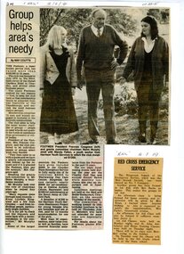
Newspaper, Newspaper cutting detailing the function of the Footmen Club in helping lesser know Clubs and Charities with financial donations. Article is from the "Mail Newspaper" dated 12/6/1991
Newspaper cutting.Heading on cutting: Group helps area's needy. Reporter - May Coutts. -
 Geoffrey Kaye Museum of Anaesthetic History
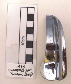
Blade, Laryngoscope, Macintosh, Model Circa 1943
The design of this item is associated to what was "first described by Professor R. R. Macintosh in the Lancet of February 13th, 1943, this design is now the acknowledged leader throughout the world." (PENLON, 1969) Reference: PENLON. 1969. Anaesthetic Equipment - Longworth Scientific Instrument Company LTD. Abingdon, Berkshire, England. January 1969. The manufacturer of this blade is the Boots UK Limited pharmacy company, they apparently had a branch in Australia to distribute their medical and pharmaceutical equipment and part of them was focused on the manufacturing of laryngoscopes blades. The Boots company reproduced this trending design used in the anaesthetic practice. URL Reference: https://en.wikipedia.org/wiki/Boots_UK / https://en.wikipedia.org/wiki/Alliance_Boots Macintosh semi curved blade designed in a baby size, without light bulb attached. Minor scratches and some slight hit marks over the piece surface caused by its previous use. It has the manufacturer name and brand and the place where it was made at the back of the blade base.Stamped at the blade back base area, BOOTS AUSTRALIA / MADE IN ENGLANDmacintosh, blade, boots australia, boots uk limited, england blade -
 Tatura Irrigation & Wartime Camps Museum
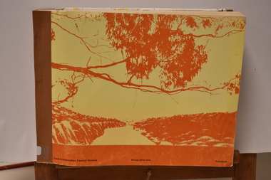
Book - Land Conservation Council Victoria ( Murray Valley Area ), Land Conservation Council Victoria ( Murray Valley Area )
Report on public land use in the Murray Valley area in 1983Mediun size, Yellow and Orange Front Cover. Brown fabric Spine. White back. Heavy white envelope inside back cover that contains mapsnon-fictionReport on public land use in the Murray Valley area in 1983soils and land use -
 Stawell Historical Society Inc
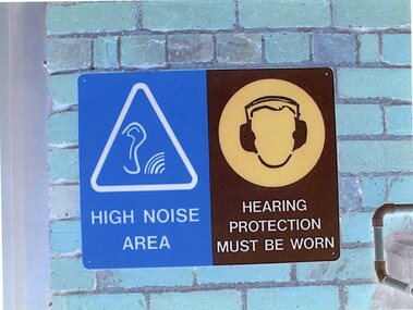
Photograph - Aunde Album 29, Safety Signs, 2002
Aunde / Norwellan Textiles North Western Woolen Mills became Norwellan Textiles then AUNDEColour landscape photo: Blue brick wall with (2) Two signs Blue White triangle. Ear with Sound waves. Brown head with Hearing protection1 - High Noise Area 2 - Hearing Protection must be wornindustry, aunde -
 8th/13th Victorian Mounted Rifles Regimental Collection
Photograph
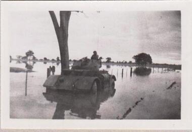
The 8th/13th Victorian Mounted Rifles was raised as a regiment of the Royal Australian Armoured Corps on 1 May 1948 with Headquarters in Melbourne and squadrons in Sale, Benalla/Wangaratta and Albury. In 1955 Regimental Headquarters moved to Wangaratta and a second squadron was located at Albury. The Sale squadron transferred to 4th/19th Prince of Wales’s Light Horse. In 1977 8/13 VMR Regiment was reduced to an independent squadron A Squadron 8th/13th Victorian Mounted Rifles and in 1991 was linked with 4th/19th Prince of Wales’s Light Horse forming the VMR Squadron of that regiment.Collection of photographs showing early evolution of an armoured regiment of the Citizen Forces as it progressed from WWII equipment and uniforms to post-war equipment and uniforms. Silver regimental hat badges are worn in place of Rising Sun badge.Black and white photograph of Staghound Armoured Car wheel-hub deep in flood water' 1956 Staghound Armoured Car settling. Exercise in Chiltern/ Rutherglen area. " -
 Department of Health and Human Services
Photograph, Olivene - Beechworth - Mayday Hills Hospital
handwriting on the back of photograph; showing area of Olivere prior to commencing landscaping. -
 Ballarat Tramway Museum
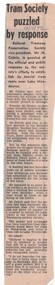
Newspaper, The Courier Ballarat, "Tram Society puzzled by response", 13/12/1972 12:00:00 AM
Newspaper clipping from The Courier, 13/12/1972, with the BTPS Vice President Mr. M. Calnin expressing puzzlement at the official and public response to the Society's efforts to establish its tourist tram route near Wendouree Parade. He contrasted this to the enthusiasm in Bendigo. Also mentions the development of Sovereign Hill. Notes track laying work underway this weekend.date in blue ink of "13/12/72" in top area of cutting.trams, tramways, btps, trackwork, museum establishment -
 Ballarat Tramway Museum
Document - Instruction, State Electricity Commission of Victoria (SECV), "Notes: / Applicants for Inspectorship ", Sept. 1957
Two page foolscap size typed (carbon copy) instruction sheet titled "Notes: / Applicants for Inspectorship", Dated 20/9/1957 and pinned together in the top left hand corner. Asks 10 questions of a varied nature Has the answers within the paragraph. Has initials AVM/ERA in top left hand corner. Asks questions re duties, instructions, towing or pushing trams, track obstructions, ticket irregularities, intoxicants, derailments, rerailing of bogie trams, serious accidents and honesty of conductors.In black ink in top right hand area of instruction "BTPS 322." trams, tramways, sec, instructions, traffic staff, inspectors, accidents -
 Ballarat Tramway Museum
Document - Instruction, State Electricity Commission of Victoria (SECV), "Questions / Applicants for Inspectorship ", May. 1963
Three page quarto size typed (carbon copy) instruction sheet titled "Questions / Applicants for Inspectorship", Dated 31/5/1963 and pinned together in the top left hand corner. Asks 10 questions of a varied nature Has initials LJD/PB in top left hand corner. Pages 2 and 3 detail the suggested answers. Asks questions re people found damaging SEC property, trolley wire on road, derailments, track obstructions, ticket irregularities, pedestrian accidents, traffic, drunken crews, passenger complaints and duties.In black ink in top right hand area of instruction "BTPS 323." trams, tramways, sec, instructions, traffic staff, inspectors, accidents -
 Friends of Ballarat Botanical Gardens History Group
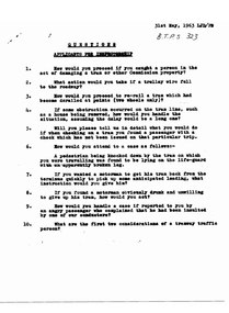
Work on paper - "Haunt of Gordon's" Newspaper Article pre 1934, Cottage a Treasured Reminder: A Relic of the Sixties", pre 1934
The page gives unique information about Adam Lindsay Gordon and a picture of the Gordon Cottage in its original state.The heading and by-lines in the Ballarat Courier attest to the significance of the extract and picture: "Haunt of Gordon's. Cottage a Treasured Reminder, A Relic of the Sixties".There are three sections to the newspaper article and one picture in the centre of the page. 2 sections are on the lefthand side of the page and one section above the picture; all roughly cut out. There is the number 17 recorded on the lefthand side of the main heading. Some lines have been roughly underlined.Written in longhand, righthand corner is, Shopping area, Ballarat and underneath Courier.john garner, doctor, john garner collection, ballarat botanical gardens, friends of the ballarat botanical gardens, ballarat courier, adam lindsay gordon cottage, craig's hotel, bath lane, australian "horseman poet", livery stables, o'farell's horse bazaar, gardens, ballarat -
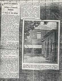
 Numurkah & District Historical Society
Domestic object - Tobacco Cutter (early 1900's), ?1900
Cast iron tobacco cutter (McMillan cutter). It is a guillotine style cutter used to cut plugs of tobacco to put into smoking pipes. The cutter is held to a wooden base with screws and has a well-worn wooden striker plate. (Originally painted black). Metal tobacco cutter mounted on timber plinth by 4 screws.Metal previously been painted black. (1900s)Mc Millan etched in black ink onto the timber table area.tobacco cutter, tobacco, pipe, smoking -
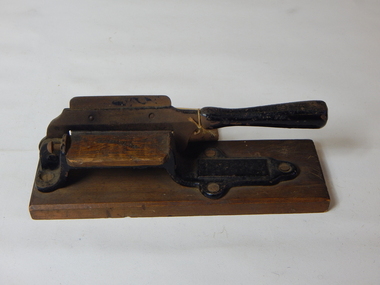
 Blacksmith's Cottage and Forge
Wireless/ Radio, 1950 (estimated)
This unit was designed and manufactured in a factory where many local people of Bacchus Marsh worked. Ref. Historical Notes-Significance Assessment Study ( October 2008)Bakelite tabletop radio,small box,camel-coloured leatherette covered,glass front,three dials,electrical cord,4 vlave reflex super heterodyne, cord attached, incription on set reads "MARSHMAN MUSIC MASTER".Maker's mark in blue print "MARSHMAN MUSIC MASTER" (Inscription on the central area of the glass front of the unit) "BROADCAST" is printed in cream twice in the area of the radio Frequency Band listings.electrical, , bacchus marsh, bakelite, radiogram, bob butler, post war invention, leatherette, technology, 1950 s, small scale radio, heterodyne, cabinet radio, arbee supply c0, civilian radio, manufacturer s drawings, wiring layout, console model -
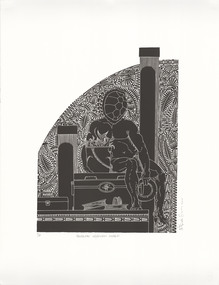 Latrobe Regional Gallery
Print, ROBINSON, Brian. Born 1973, Waiben, Queensland, Australia, Handline Ngurupai Wharf, 2011
Linocut print on paper. Printer's Proof.'P/P' under bottom left section of printed area, 'HANDLINE NGURUPAI WHARF' centred under printed section, signed along bottom right edge of print area.linocut, cultural reference, pattern, figure, fishing -
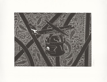 Latrobe Regional Gallery
Print, ROBINSON, Brian. Born 1973, Waiben, Queensland, Australia, …And they flew from the Airfield at Ngurupai II, 2011
Linocut print on paper. Printer's Proof.'P/P' bottom left under printed area, '...AND THEY FLEW FROM THE AIRFIELD AT NGURUPAI II' centred under printed area, signed along bottom right edge of printlinocut, cultural reference, pattern, symbolism, aircraft -
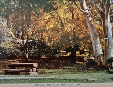 Falls Creek Historical Society
Postcard - Junction Dam, Kiewa Hydroelectric Scheme
These photographs were taken in and around Mount Beauty and the Kiewa Valley by Samuel Keith Pearce and printed for him as a foldout postcard by NuColor Vue. The postcards state they were printed for S. K. Pearce Pty. Ltd of Tawonga and Mount Beauty. Samuel Keith Pearce was born on 24 June 1917 in Armadale, Victoria. By the late 1940s he owned the Mt Beauty Supermarket, Newsagency, Drapery and Hardware store at Mount Beauty and also a store at Tawonga in partnership with his brother Gordon Cathew Pearce. For some time, they operated as Pearce Brothers. In the early 1960s Keith also opened a mini mart In Falls Creek. As well as being a keen photographer and an astute businessman, Keith Pearce was a well-known identity in the Kiewa Valley, making many contributions to the development of the area over a long period. This included serving as a member of the Bright Shire Council for many years. He worked hard to promote the interests of the Upper Kiewa Valley. As a sign of recognition and appreciation for his contribution to the community, the park opposite the grocery store in Mount Beauty was named the SK Pearce Gardens in his honour. Samuel Keith Pearce died on 7 July 1994 in Mount Beauty, Victoria Junction Dam, also known as Lake Guy, is situated 16 kms from Mt Beauty, along the Bogong High Plains Road. It was built by the State Electricity Commission of Victoria as part of the Kiewa Hydro Electric Scheme. This collection of postcards and images is significant because they were commissioned by a highly successful businessman in Falls Creek, Victoria.A colour image of Junction Dam in the Upper Kiewa area, showing a bench and autumn trees.mt. beauty, junction dam, lake guy, kiewa hydroelectric scheme -
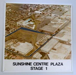 Sunshine and District Historical Society Incorporated
Photograph (1982) - Part Sunshine Business Area, Sunshine Centre Plaza Stage 1, 1982
The Sunshine business area has undergone major change from industrial manufacturing to retail. This aerial photograph shows the industrial areas that existed on both sides of Hampshire Road in 1982, and which have since been replaced by two shopping centres and the library building. The photograph also shows the old swimming pool, and retail outlets that no longer exist such as Waltons, Clark Rubber, Fosseys and the original Safeway store. It also shows a vacant land where the current Centrelink office now exists. The photograph was originally used as a promotion for the Sunshine Centre Plaza retail complex.This photograph is a historical record of what part of Sunshine looked like 3 decades ago.Large cardboard mounted sepia photograph with thin white plastic edging. Grey painted outline shows the site in 1982 on which the SUNSHINE CENTRE PLAZA was to be built, as well the buildings that then existed in part of the business area of Sunshine.Sunshine Centre Plaza Stage 1aerial view, 1982, sunshine centre plaza, sunshine business area, massey ferguson buildings, old sunshine pool. waltons -
 Greensborough Historical Society
Book, Typical Homes that would be constructed by Mitchell Trading Pty Ltd, 1960_
An early advertising brochure for prospective homeowners to choose the style of home they would like built. House and land packages were available in the areas of Bundoora surrounding the Loyola and Parade College sites, which were monasteries in the 1960s. The aerial photographs show the open nature of the landscape from Bundoora across to Greensborough and Watsonia in the 1960s. Book of black and white photographs bound in brown card cover. Contains 14 photos of houses and shops and 14 aerial photos of Bundoora including the Loyola and Parade College areas. Includes notes from Gary Partington.In pencil inside front cover: 29/1/1960.houses, bundoora, greensborough, watsonia, loyola college, parade college, mitchell trading, aerial photography -
Whitehorse Historical Society Inc.
Book, Suburban heartland, 2010
A history of the City of Whitehorse and its two former cities, City of Box Hill and City of Nunawading.A history of the City of Whitehorse and its two former cities, City of Box Hill and City of Nunawading. The aim of the new history is not to replace separate histories of each city, previously published but to meld together the area's shared history and to bring the story up to the present.A history of the City of Whitehorse and its two former cities, City of Box Hill and City of Nunawading. city of nunawading, city of box hill, city of whitehorse -
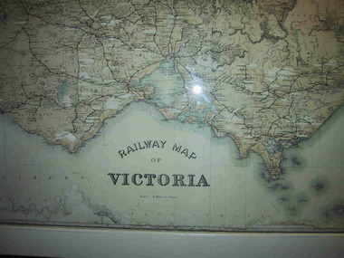 Parks Victoria - Mount Buffalo Chalet
Map, "Railway Map of Victoria"
Large framed map of Victoria, showing Victorias extensive rail network. Printed by Victorian Railways and is one of a number of 'framed pictures, particularly photographs of scenery, which have always been a feature of the Chalet.' (Pg 83. Historica, 2011) This map has been a permanent fixture situated in the hallway alongside the ballroom leading to the ski hire area since the 1950's and most likely earlier. Listed in Draft Inventory of Significant Collection ItemsLarge railway map of Victoria, Melbourne & Ballarat framed in white painted wood. Scale eight miles to one inch. Areas of the map have been whited out.Yes -
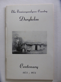 Warrnambool and District Historical Society Inc.
Booklet, The Temiangandeen Country Dergholm, 1973
This booklet gives information on the settlement of Dergholm at the time of the centenary of its founding, 1973. The origin of the name Dergholm is unclear but it may have Irish connections. Europeans came to the area in the 1840s and 50s but it was not until the 1870s that the town was surveyed. Dergholm is in the far west of Victoria 334 kilometres from Melbourne and nearby is Dergholm State Park established in 1982. The booklet was produced for the Centenary Back to Dergholm Committee and the local centenary celebrations. This book is of some interest as it provides information on Dergholm, a settlement in the far west of Western Victoria. This is a soft cover booklet of 52 pages by Alistair Roper. It has a cream-coloured cover with a black and white photograph of early Dergholm on the front cover (Edward Quinn’s house). The booklet has printed material - a President’s Message, an Author’s Note, Acknowledgements, Contents, information on the Dergholm area, including a list of local birds, and References. There are several black and white photographs of the area and its people. The book is stapled. Front Cover: ‘The Temiangandgeen Country, Dergholm Centenary, 1873-1973’dergholm victoria, alistair roper, history of western district of victoria -
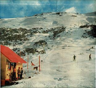 Falls Creek Historical Society
Newspaper - Australia's Playground of the Future
Australian Magazine (A.M.) published a special three page article about Falls Creek and the Bogong High Plains on 24th August 1954. The article was titled "Australia's playground of the future". Written by Muir Maclaren, it referred to the Bogong High Plains as a comparatively new and unexploited winter playground which could be one of the best snow resorts in the world. There were 13 huts which were at Falls Creek which were there due to "hard work, the grace of God, and the permission of the Victorian State Electricity Commission". A brief history of the Albury Ski Club Lodge was included. In 1954 the Lodge was run byLes Meikle and had the Club had a membership of 200 people. Lodges with accommodation established at this time, with the ability to house a total of 280 people, included Albury, Skyline, Bogong, Myrtleford, Hymans, Dawn, Galleon, Kiewa Valley, Snowden, Nelse, Moroma, Trowalla, St, Trinian's, Bowna and Nissen. Fred Griffith, as a member of the Albury Ski Club and owner of Bowna Lodge escorted the reporter and explained the potential of Falls Creek and the surrounding area to become a year-round playground, a paradise for tourists and a great income-earner for the State.This article and accompanying images are significant because they capture early information about the Bogong High Plains, Falls Creek and its pioneers.A centre spread from a monthly publication featuring text and colour imagesBelow photo The ski tow at the foot of Bogong High Plains, an area of 280 square miles of unequalled ski-ing country.fred griffith, falls creek pioneers -
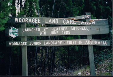 Wooragee Landcare Group
Photograph, 2004
This photograph of the Wooragee Landcare Area signage was included in the album alongside the statement that, when the photo was taken in 2005, the Wooragee Landcare Group had applied for a council grant for new signs with which they could replace the broken sign in the photograph. The sign marks the Woooragee Landcare Area, opened in 1989 by Heather Mitchell, one year after the first meeting of the Wooragee Landcare Group. It also commemorates the 1898 founding of Wooragee Junior Landcare, which they launched with Wooragee Primary School. As stated by the sign, Wooragee Junior Landcare was the first group of its kind in Auatralia, with the nation-wide Junior Landcare organization being launched in 1998. This photograph is significant as a marker of Wooragee Landcare's need for grants and council funding, which is common to many organisations, and for demonstrating the history of Wooragee Landcare and Junior landcare by commemorating the founding of both the Wooragee Landcare Area and Wooragee Junior Landcare. Rectangular landscape colour photograph printed on gloss photographic paper.Obverse: Sign in photograph reads "Wooragee Land Care Area/ Launched by Heather Mitchell/ 6th June 1989/ Wooragee Junior Landcare First in Australia" Reverse: "WAN NA E0NA0N2. AIN+ 1 2906/ wooragee junior landcare, grants, signage, council, wooragee landcare area, heather mitchell, wooragee primary school, wooragee, wooragee landcare, wooragee landcare group, junior landcare, 1989, broken sign, youth, junior, children, landcare, landcare area, founding