Showing 968 items matching "dam"
-
 Bendigo Historical Society Inc.
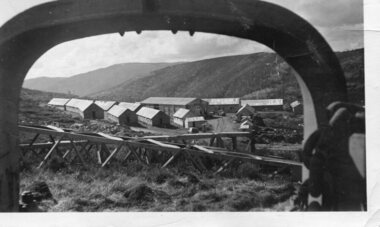
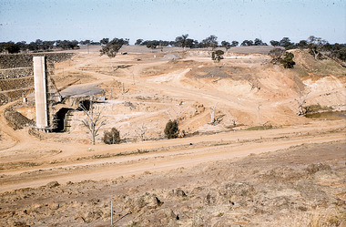
Slide - DAVID MCDONALD COLLECTION: EPPALOCK. CONSTRUCTION, c1961
Eppalock. Construction. Early stages of the construction of Lake Eppalock. Markings: Campaspe Riv. & Eppalock Dam. Project. 1961Agfacolorcivil engineering, water supply, eppalock -
 Melbourne Water
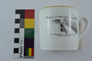
Souvenir Tea Cup, 1920s
The Maroondah System was first and foremost developed as a functional component of Melbourne's Water Supply System. In addition to functionality, the Melbourne and Metropolitan Board of Works (MMBW) envisioned the Maroondah Reserve to be enjoyed aesthetically and recreationally by the public. This souvenir illustrates the realisation of the Maroondah System as a local recreational and tourist attraction in the early 20th century. The Maroondah Reserve gardens were landscaped with English-style ornamental stonework, exotic trees, flower beds and rose gardens. All features of the water supply system became widely celebrated as beauty spots that continue to be very popular to this day with tourists and locals alike. This souvenir is a product of that flourishing tourist trade. These water supply sites continue to enhance Melbourne’s charm and liveability and are now recognised as places of cultural and historic significance.This souvenir tea cup has been curated by Melbourne Water as it represents an important historical aspect of the organisation by demonstrating the popularity of its water asset sites as recreational places and tourist attractions, and although these sites are functional parts of the water supply system, they were also designed to be enjoyed by the public both aesthetically and recreationally. Additionally, the tea cup is aesthetically pleasing, representative of 1920s style and design. This porcelain tea cup with gold trim features a black and white image of the embankment at Maroondah Dam, Healesville on the front.melbourne metropolitan board of works, melbourne water, mmbw, porcelain, tea cup, maroondah, healesville -
 National Vietnam Veterans Museum (NVVM)
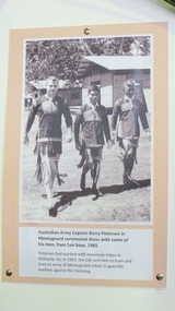
Photograph, Capt B. Peterson in Montaynard ceremonial dress
Photograph mounted on card. Capt B. Peterson in ceremonial dress with his man at Dam San base 1965photograph, capt b. peterson, ceremonial dress -
 Tatura Irrigation & Wartime Camps Museum
Book, Water and Power, 1968
History of the Snowy Mmountains Scheme to 1968-9Pamphlet/soft cover/photo of Eucumbene Dam and Lake Eucumbene on front. Table of statistics on back cover. Illustratedwater, power, snowy mountains scheme, tatura, irrigatiaon, books, reference -
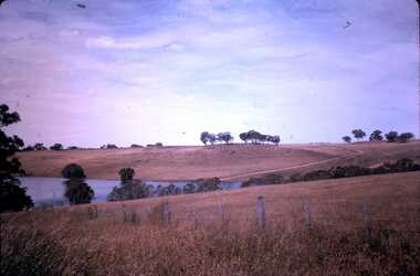
University of Melbourne, Burnley Campus Archives
Photograph - Colour print, Kodak, Excursion, Unknown
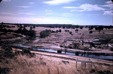
13 colour photographs taken possibly on an excursion. Views of the countryside, river, valley mountains, dams, farm buildings.excursion, countryside, river, valley, mountains, dams, farm buildings -
 Wodonga & District Historical Society Inc
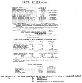
Album - Hume Reservoir Australia Album - Dimensions of Hume Reservoir, Department of Public Works, N.S.W, 1927
This set of photos is from a leather bound album bearing the inscription "HUME RESERVOIR AUSTRALIA" plus 'The Rt. Hon. L. C. M. S. Amery, P. C., M .P.' all inscribed in gold. It was presented to The Rt. Hon. L. C. M. S. Amery, P. C., M. P, Secretary of State for Dominion Affairs on the occasion of his visit to the Hume Reservoir on 2nd November 1927. This album is of local and national significance as it documents the planning and development of the Hume Reservoir up to 1927. It was the largest water reservoir in the British Empire. The album records the pioneering engineering work that went into its construction.Table outlining the Dimensions of the Hume Weir and comparisons with MAKWAR and BURRINJUCK DAMS, and some other comparisons. MAKWAR Dam is located on the Blue Nile about five miles south of Sennar and 175 miles south of Khartoum in Sudan. The construction of this dam started in 1922 and was completed in May 1925, while the British Empire colonised Sudan. It was officially opened on 21st January 1926. The BURRINJUCK DAM is situated in the upper catchment of the Murrumbidgee River, approximately 60 kms from Yass, N.S.W. It was built from 1907 to 1927 The stated purpose of the Hume Reservoir is to get storage to ensure regulated output for:- 1. Irrigation 2. Navigation 3. Hydro-electric Generation.hume reservoir australia, river murray waters scheme, hume dimensions -
 Kiewa Valley Historical Society
Photograph - Pretty Valley camp including workman's huts, Pretty Valley
At the Pretty Valley Dam site erection of staff quarters was completed in April, 1947 and accommodation for workmen commenced in 1948 but suspended on 11th May for winter and resumed on 9th November. Construction of this camp was completed in 1949. A large dam was proposed at this site but was never constructed. Instead a small diversion dam was built which diverts water either to Rocky Valley Dam or to McKay Creek Power Station.An historical record of the type of accommodation provided for workmen during the construction of the Kiewa Hydro Scheme during the 1940's/50'sBlack and white photograph of Pretty Valley camp showing workman's huts and construction materials.Handwritten on back of photograph in blue pen - Pretty Valleypretty valley, workmen's huts, victorian alps, secv -
Glenelg Shire Council Cultural Collection
Photograph - Photograph - Erosion Gully, Casterton, Victoria, n.d
Sourced from Casterton Town Hall (Former Shire of Glenelg)Black and white photo. Eroded gully with large concrete pipes in water, looking downstreamBack: Black stamp -'57' 'Soil saving dam looking downstream' - handwritten pencil 'GB 4238' -
 Bendigo Historical Society Inc.
Slide - DAVID MCDONALD COLLECTION: EPPALOCK. CONSTRUCTION, c1963
Eppalock. Construction. David fishing of the bank at Lake Eppalock. Markings: Eppalock Dam near Lyal March 1963 DavidKodakcivil engineering, water supply, eppalock -
 Bendigo Historical Society Inc.
Slide - DAVID MCDONALD COLLECTION: EPPALOCK. CONSTRUCTION, c1961
Eppalock. Construction. Fence line machinery on left side, water tanks on right. Markings: Eppalock Dam Project 1961.Agfacolorcivil engineering, water supply, eppalock -
Tatura Irrigation & Wartime Camps Museum
Book, Lake Eildon - A Record low, 2000
To record and compare water levels and to showcase the success of "Eildon Lake Charters" in Murrindindi Tourism Competition "Best New Business 2000". Book includes many old historic preflooding photos.Clear plastic dust cover. White front cover with photograph of Eildon and Sugarloaf Dam in foreground. Insert of charter boat.buesiness, flooding, boat club, books, history, local -
 Falls Creek Historical Society
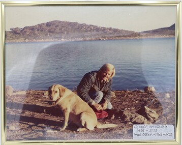
Photograph - George Shirling with his Golden Labrador
This item is from the private collection of George Shirling of Red Onion, Falls Creek. George Shirling arrived in Falls Creek in 1962. He engaged Phil Nowell to build the original Koki Alpine Lodge which opened in 1965 with 14 beds. George operated the lodge with Michael “Baldy” Blackwell as manager. He also graduated in sport psychology in 1981 and was invited to become team psychologist for the Australian Winter Olympic team which went to Albertville, France, in 1992. He later owned the Red Onion Chalet. George credited the success of Koki to “Baldy” Blackwell. “Baldy” and Phil Nowell started the Trackers Mountain Lodge in partnership during the 1980s. In 1971 George sold Koki Lodge to Sigi Doerr. In 2024 the renamed Koki Alpine resort remains a highly popular destination in Falls Creek. George Shirling passed away on 27th February 2023. He had remained actively involved in Falls Creek and was generous with his time and knowledge, always an amazing supporter of The Falls Creek Museum and Falls Creek Village.This item is significant because it is a portrait of George Shirling, a significant pioneer of Falls Creek and the ski industry in Australia.A framed colour photo of George Shirling with his Golden Labrador at the dam. A title label has been added to the image.On Label: George Shirling 1938 - 2023 Falls Creek - 1962 - 2023george shirling, koki lodge, red onion -
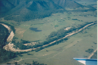 University of Melbourne, Burnley Campus Archives
Photograph - Colour print, Aerial View of Countryside, Unknown
4 colour photographs taken from a small aeroplane. Views of countryside, river, valley, mountains, dams, farm buildings countryside, aerial views, river, valley, farm buildings, dams, mountains -
 Wodonga & District Historical Society Inc
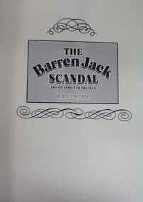
Book - The Barren Jack Scandal and its Effects on the M.I.A, W. R. Cowper, 1987
This book outlines the issues and controversy around the construction of the Barren Jack (Burrinjuck) Water Supply Dam as part of the infrastructure of the Murrumbidgee Irrigation Authority (M.I.A) and its subsequent abandonment. It has now fallen into disrepair,non-fictionThis book outlines the issues and controversy around the construction of the Barren Jack (Burrinjuck) Water Supply Dam as part of the infrastructure of the Murrumbidgee Irrigation Authority (M.I.A) and its subsequent abandonment. It has now fallen into disrepair,irrigation -- government policy, murrumbidgee irrigation area (n.s.w.) -- history, barren jack dam, burrinjuck, yass valley -
 Federation University Historical Collection
Book, Hydraulic and Placer Mining, 1898, 1905
Blue/black hard covered book of 234 pages including index and photographic reproductions. Contents include Uses of Water in Mining; Geology of Placer Deposits; Gold Recovery; Flumes, ditches, dams, pipes; Giants, valaves, gates, weirs, miner's inch, pressure box, dams; gravel elvators; exploiting. mining, hydraulics, water, dredge, dredging, gold mining -
 Rutherglen Historical Society
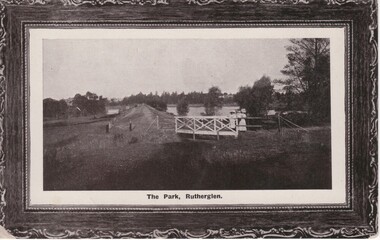
Postcard, 1910-1920 (Approximate)
Black and white photograph, printed on postcard, with decorative printed frame. This one shows a view along the weir of Lake King, from the western end, with the bridge over the spill-way in the foreground,At bottom of photo: "The Park, Rutherglen"lake king, rutherglen park, dam -
 Wodonga & District Historical Society Inc
Album - Hume Reservoir Australia Album - View from the Victorian bank of the Murray River, May 1923
This set of photos is from a leather bound album bearing the inscription "HUME RESERVOIR AUSTRALIA" plus 'The Rt. Hon. L. C. M. S. Amery, P. C., M .P.' all inscribed in gold. It was presented to The Rt. Hon. L. C. M. S. Amery, P. C., M. P, Secretary of State for Dominion Affairs on the occasion of his visit to the Hume Reservoir on 2nd November 1927. This album is of local and national significance as it documents the planning and development of the Hume Reservoir up to 1927. It was the largest water reservoir in the British Empire. The album records the pioneering engineering work that went into its construction.DEPARTMENT OF PUBLIC WORKS, N.S.W. RIVER MURRAY WATERS SCHEME. HUME RESERVOIR. 12. View from the Victorian bank of the river showing in the foreground a levee bank along the New South Wales side of the river with connecting wings back to the higher ground, May 1923. The first stage in the construction of the Dam foundations was carried out inside the levee bank which was at a sufficient height to protect from floods the work going on inside. A length of 300 feet of the Dam was left at a low elevation to allow of the river flowing over it in the second stage of the operations and at the ends of the concrete was brought up above flood level. To divert the river, a Coffer Dam was built across the old bed above and below the Dam site and tying into the end of the concrete wall built inside the levee bank. This completely surrounded the remainder of the site of the Dam and south wing wall, including an area of 12½ acres.hume reservoir australia, river murray waters scheme, hume reservoir construction -
 Falls Creek Historical Society
Photograph - Inside Pretty Valley Camp Kitchen
MEYER COLLECTION - FALLS CREEK PHOTOS In 1947 a determined group of like-minded State Electricity Commission (SEC) staff including Ray Meyer, the chief surveyor of the Kiewa Hydro-Electric Scheme, had a common interest that revolved around the skiing potential of the snow-covered high plains which included what is now the resort of Falls Creek. The six SEC employees, Toni St Elmo, Ray Meyer, Jack Minogue, Lloyd Dunn, Adrian Ruffenacht and Dave Gibson (together with their families) banded together to secretly build a 'hut' that was the first ski lodge at Falls Creek. Using a road built in 1930s to gain access to Falls Creek, their hut project was carried out in secret as efforts by other skiers were blocked by H.H.C. Williams – the engineer in charge of the Hydro Scheme. In 1946 Ray Meyer made a trip to the Lands Office in Melbourne. He came away with a 99-year lease on three acres that was ideally suited for a hut designed by Lloyd Dunn. Adrian Ruffenacht (Design Engineer for the KHS) had suggested where the group should build because of easy access to a spring for water. Much of the building material required was scavenged from derelict huts on the high plains. Due to the need for secrecy, the determined group worked on the hut in the evenings and weekends to avoid detection. During the building period the group had met at Echidna Rock (now known as Eagle Rock) where Skippy St Elmo announced, "This is my favourite ‘Skyline’.” And so the first lodge in the area at Falls Creek Ski Resort came into existence. With the development of the International Poma in the 1970s, the Skyline Lodge, which was sited between the ski-lift’s pole one and pole two, was demolished. However, the legacy of Ray Meyer, Toni St Elmo, Jack Minogue, Lloyd Dunn, Adrian Ruffenacht and Dave Gibson and Skyline lives on in the vibrant atmosphere of Falls Creek Resort. The MEYER COLLECTION documents developments on the Kiewa Hydro Scheme and their life at Falls Creek from the mid 1930s to 1960s.This image is significant because it documents the development of the Kiewa Hydroelectric Scheme.A black and white photo taken inside the Pretty Valley Camp kitchen. Staff quarters was completed in April, 1947 and accommodation for workmen commenced in 1948 but was suspended from May until November. Construction of this camp was completed in 1949. A large dam was proposed at this site but it was never constructed, being replaced by a smaller diversion dam.falls creek, victorian snowfields, pretty valley -
 Kiewa Valley Historical Society
Postcard - Lake Guy and Bogong Village
In 1940 Field Headquarters for the Kiewa Scheme were established at Bogong with office, workshop facilities and accommodation for workmen, staff and some families constructed. (There had been a 'tent camp' on this site in 1939 but was destroyed by bushfires) Construction of accommodation continued until 1947. A total of 40 houses plus a hostel for single staff, post office, police station, medical centre and primary school all with water and sewerage and electricity supply. The staff hostel was known as Kiewa House and is now occupied by the Education Department. Lake Guy was named after Mr. L.T. Guy who was the Resident Engineer in charge of construction work and associated activities on the Kiewa area. He held this position from 1939 to November 1946 when he was transferred to Head Office. The Bogong Township was developed firstly as an accommodation centre (base camp) for construction workers employed under the Kiewa Hydroelectric Scheme. Due to the influx of European workers into the Township the beautification of the immediate surrounds (gardens etc.) had a distinct European flavour. This environment has been very beneficial for tourism in later years. At the completion of the scheme, in the 1960's, the village was opened to public/tourism use. Strict environmental control has not allowed for any extensive redevelopment in tourist accommodation and basically restricted it to the accommodation initially built for the construction workers. Activities such a bike riding, snow skiing, restricted horse riding and bush walking on the Alpine plains and mountains are now a viable part of the Kiewa Valley Tourist Industry. The lake is one of the many water storage reservoirs used to supply the power stations their main power to run the huge turbines generating the final product, electricityBlack and white photographic postcard of Lake Guy and Bogong Village. Kiewa Hydro electric Project (showing Junction Dam in front)Handwritten on the back of postcard ' Like most of our camps, this looks like something from the Canadian Rockies' Stamped on the back - Valentine's Post Card A genuine photographlake guy, bogong village, secv -
 Bendigo Historical Society Inc.
Photograph - QC BINKS COLLECTION: BLUE MINE DAM
Sepia copy of original. Accompanying text : sunbathing on sand dump at 'The Blue Mine Dam', off Breen Street, Bendigo 1938person, individual, cliff binks, binks, blue mine -
 Bendigo Historical Society Inc.
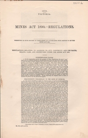
Document - MINES ACT 1890 - REGULATIONS, 1890
Mines Act 1890 - regulations. Relating to cut, construct and use races, drains, dams and reservoirs under the Mines Act 18980.G. Wilson Brown, Clerk.government, state, mines act, mines act, mining, gold mining -
 Whitehorse Historical Society Inc.
Photograph, Jones Flower Farm
Jones Family Collection - NP2565 to NP2606. See also ND3831.Black and white photograph of water storage dam with the Dandenongs in the backgounnd - Jones' Flower Farm in Mt Pleasant Road, Nunawading, in 1928jones, bette, walter, rolf, geoffrey, arthur, keith, lionel, muriel, jones flower farm, mount pleasant road nunawading -
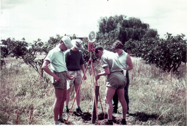 University of Melbourne, Burnley Campus Archives
Photograph - Colour print, Sojourn Tatura District, 1960
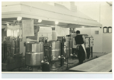
Notes by E.B. Littlejohn and T.H. Kneen, "Sojourn experience-Tatura District. John Richards' year (first Diploma intake)." (A) Inflectometer in use. (B) Works are being explained by Leo Van Heetz (HRS staff), in white shirt, to a group of students.Colour photographs. (A) Students using an inflectometer. (B). Group of students standing on a dam. Leo van Heetz Explaining Irrigation Works.On reverse, "Kodak Colour Print made by Kodak ? June, 1960."sojourn experience, tatura district, john richards, irrigation system, tatura station, inflectometer, leo van heetz, students -
 Bendigo Historical Society Inc.
Slide - EPPALOCK. CONSTRUCTION, c1962
Eppalock. Construction. Shows water in the bottom of the lake, or possibly river running into it. Markings: Eppalock Dam. Dec 1962 near Lyal.Kodakcivil engineering, water supply, eppalock -
 Bendigo Historical Society Inc.
Slide - Mouat Crawford Collection: Farming Life in the Wimmera, c1962
BHS CollectionThe making of Lake Eppalock, dam bank and water tower are up. Markings: Eppalock Res near Bendigo. Used as a teaching aid.Kodakmouat crawford collection, wimmera, lake eppalock construction, irrigation -
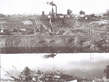
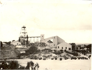 Bendigo Historical Society Inc.
Photograph - CENTRAL NELL GWYNNE GOLD MINE
Black and white photograph. Poppet legs. Corrugated iron buildings and associated mine equipment. Dam in foreground. Three houses at R. Inscriptions: on back - rubber stamp 'Central Nell Gwynne Gold Mining Company. No liability:mine, gold, central nell gwynne mine, bendigo, mines and mining, mines, mining, poppet head, landscape -
 Bendigo Historical Society Inc.
Document - MINING REPORTS - LONDONDERRY SHAFT NO 249
' The old Londonderry Mine shaft has been capped after it opened in late July. The shaft was part of the Garden Gully Line, which held the greatest concentration of workings on the Bendigo Goldfield, has been capped after it opened in late July. The line starts under the Quarry Hill Golf Course and continues right through to Eaglehawk North'. (Source: Bendigo Advertiser, August 19, 2014.) Mine was located on Creek Street North, Bendigo. Central Deborah - Heritage Victoria Notes: Originally the Londonderry West shaft, now a mining museumHandwritten extracts by Albert Richardson (with typed copy of same) on the Londonderry Shaft, Bendigo in 1905, with reference to the brick dam being constructed.gold, mining reports, londonderry shaft no 249, w westhead -
 Surrey Hills Historical Society Collection
Photograph, Muriel Pornitz (deceased), Quarry on site of Grovedale Road - James Street Park
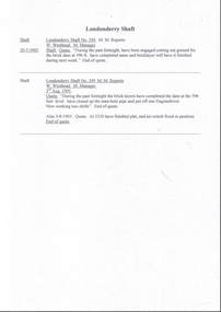
The photo is of a painting of the dam formed on land between Grovedale Road and James Street, Surrey Hills. It was painted in 1927 by Miss Muriel Pornitz, an art teacher, who lived in Grovedale Road. The land had been part of Mr James Maling Snr’s property and in the 1880s clay was removed to build houses, including his own located on the corner of Weybridge and James Streets. Maling grazed cattle on this area and used it as a dam. The land was subsequently made into parkland, the quarry / dam having been filled in after several drownings had occurred in the 1920s/1930s. See also SHP94, another copy of the same. Muriel Hedwig Lucy Pornitz lived at 22 Grovedale Road, Surrey Hills. She was born c1894 in Balwyn; died in Kew on 1 December 1982. She was the daughter of Konrad Pornitz (1864-1903) and his wife Charlotte Richardson Gooderidge (1863-1942), known as Tottie, who married in 1890. Konrad Pornitz is listed in the 1892 directory as living in Edgevale Road, Kew and the business Pornitz and Ross at 291 & 293 Little Collins Street, importers and commission merchants. The 1896 directory gives the Kew address as 176 Edgevale Road, Kew, however the business Pornitz and Ross was dissolved on 1st day of October 1892, by mutual agreement. Legal notice advised that: Mr Pornitz will hereafter carry on the business on his own behalf at the same address, under the style "Pornitz and Ross". Muriel is buried in Box Hill Cemetery (B-086-0042) along with Ulrich Horst Holm Pornitz known as Horst or Bon (d 1957) and Edith Olga Pornitz (d 1951), her brother and sister. A further sibling (Konrad b 1891) died in infancy. He is buried with his mother in Boroondara (Kew) Cemetery - C/E A 0366. Konrad died at his home 'Yarran' in Lane Cove Road, North Sydney on 31 October 1903; reported in the Sydney Morning Herald. Buried Gore Hill Cemetery, St Leonards, North Sydney. The headstone reveals he was born in Chemnitz, Saxony in 1863. Muriel was also known as Muriel Pornett. She studied at the South Australian School of Arts & Crafts in 1911 under James Ashton and Fred Britton, and at the Australian School of Etching in Sydney. She was also an illustrator and cartoonist. The photo, and the painting from which it is derived, documents the landscape prior to close settlement and is material to early building and farming in the Surrey Hills area.A black and white photograph of a painting of a landscape of parkland. Two trees are on top of a rise and are reflected at the bottom in water. The signature of the artist is in the bottom right corner: "AUST MP 192" (and the rest is cut off).(miss) muriel pornitz, grovedale road, james street, surrey hills, artists, parks and reserves, (mr) john butler maling, snr, quarry, dam, (miss) muriel hedwig lucy pornitz, box hill cemetery, muriel pornett -
 Bendigo Historical Society Inc.
Photograph - WES HARRY COLLECTION: ROYAL HUSTLERS MINE, Early 1870's
Sepia toned photograph depicting the Royal Hustlers Mine and dam within Rosalind park, this was 1150' deep. (The mine, not the dam) Three other mines on the same line are clearly visible to the north. The Imperial Hustlers is behind the Hotel, with the Hustlers Extended behind it again. The Great Extended Hustlers Tribute shaft (1970') is on the far hill.topic, mining, hustler's, upper reserve dam, royal hustlers mine, imperial hustlers, hustlers extended, great extended hustlers tribute shaft, imperial hustlers hotel. -
 Ringwood and District Historical Society
Photograph, View of Rawson's land -Ringwood -Circa 1909
Black and white photograph"Written on back of photograph" Dam behind Stoch's on Rawson's,then Frank Walker's land. Wombolano Park area 1909