Showing 1164 items matching "demolitions"
-
 Kew Historical Society Inc
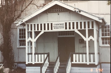
Photograph - 1st Kew Scout Hall, Disraeli Street, 1992
The 1st Kew Scouts was one of the first Scout Troops in Victoria, being formed in 1909. From 1927 they met in a magnificent Scout Hall in Disraeli Street, Kew until it was demolished in 1993. Still operating (in 2020) from their new Scout Hall on the corner of Kilby Road and Kellett Grove, Kew.Original colour positive photograph of the 1st Kew Scout Troop's single-storey wooden hall in Disraeli Street, Kew, prior to the building's demolition and the relocation of the troop to a new site."1st Kew Scout Hall / Cr Disraeli and Childers St North Kew. Demolished ... Re-established Cr Kilby Rd & Kellett Grove. Nth Kew .."scout troops -- kew (vic.), 1st kew scouts, scout halls -- kew (vic.), scout halls -- melbourne (vic.), boy scouts -
 Kew Historical Society Inc
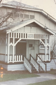
Photograph - 1st Kew Scout Hall, Disraeli Street, 1992
The 1st Kew Scouts was one of the first Scout Troops in Victoria, being formed in 1909. From 1927 they met in a magnificent Scout Hall in Disraeli Street, Kew until it was demolished in 1993. Still operating (in 2020) from their new Scout Hall on the corner of Kilby Road and Kellett Grove, Kew.Original colour positive photograph of the 1st Kew Scout Troop's single-storey wooden hall in Disraeli Street, Kew, prior to the building's demolition and the relocation of the troop to a new site."1st Kew Scout Hall / Cr Disraeli and Childers St North Kew. Demolished ... Re-established Cr Kilby Rd & Kellett Grove. Nth Kew .."scout troops -- kew (vic.), 1st kew scouts, scout halls -- kew (vic.), scout halls -- melbourne (vic.), boy scouts -
 Kew Historical Society Inc
Photograph - 1st Kew Scout Hall, Disraeli Street, 1992
The 1st Kew Scouts was one of the first Scout Troops in Victoria, being formed in 1909. From 1927 they met in a magnificent Scout Hall in Disraeli Street, Kew until it was demolished in 1993. Still operating (in 2020) from their new Scout Hall on the corner of Kilby Road and Kellett Grove, Kew.Original colour positive photograph of the 1st Kew Scout Troop's single-storey wooden hall in Disraeli Street, Kew, prior to the building's demolition and the relocation of the troop to a new site."1st Kew Scout Hall / Cr Disraeli and Childers St North Kew. Demolished ... Re-established Cr Kilby Rd & Kellett Grove. Nth Kew .."scout troops -- kew (vic.), 1st kew scouts, scout halls -- kew (vic.), scout halls -- melbourne (vic.), boy scouts -
 Canterbury History Group
Photograph - The site of the new Canterbury Baptist Church, 1961
Black and white photograph copied by Jan Pigot from the album kept at the church, of the site of the new Canterbury Baptist Church in Balwyn Road after demolition of the old church in 1961.canterbury, balwyn road, canterbury baptist church, construction sites, churches -
Lakes Entrance Historical Society
Book, Black, Bill and Rash, Esme, Report, Burra Charter, 2007
Report, using guidelines as outlined in the Burra Charter, on the building on the northern end of the Port Albert wharf, currently used by Port Albert Seafoods. The building is due for demolition in April, 2007.township, waterways -
 Lakes Entrance Historical Society
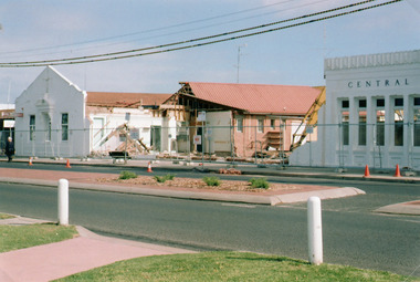
Photograph - Central Hotel demolition, Holding M, 2005
Date made May 2005Colour photograph showing progress of the demolition for redevelopment of the Central Hotel, taken from opposite side of the Esplanade in carpark. Shows part of 1930 frontage that will be restored. Lakes Entrance Victoriahotels, architecture -
 Eltham District Historical Society Inc
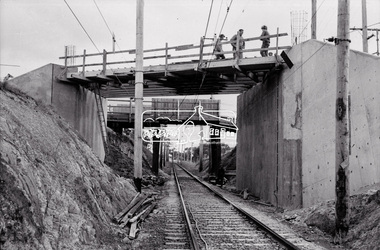
Negative - Photograph, Russell Yeoman, New road bridge under construction over railway line at junction of Sherbourne and Para Roads, Briar Hill, 1971
New bridge in foreground. Old bridge in background before demolition. This photo forms part of a collection of photographs gathered by the Shire of Eltham for their centenary project book,"Pioneers and Painters: 100 years of the Shire of Eltham" by Alan Marshall (1971). The collection of over 500 images is held in partnership between Eltham District Historical Society and Yarra Plenty Regional Library (Eltham Library) and is now formally known as the 'The Shire of Eltham Pioneers Photograph Collection.' It is significant in being the first community sourced collection representing the places and people of the Shire's first one hundred years.Digital image 35 mm B&W negativesepp, shire of eltham pioneers photograph collection, montmorency, briar hill, bridge, para road, railway bridge, railway line, road construction, sherbourne road, bridge construction -
Port Melbourne Historical & Preservation Society
Plaque, Port Melbourne Administration building, Parks and Gardens depot
Plaque removed from building upon its demolition in 2018Bronze or brass plaque installed on the City of Port Melbourne Parks and Gardens depot administration building when the building was officially opened on 28th July 1986"City of Port Melbourne Parks and Gardens depot. This admonistration and amenity building was officially opened on Monday 28th July 1986 by the Mayor Councillor Perce White JP. Councillors: T T Buckingham; P White JP; B J Mitchell; R F Julier; F R Winduss; N Tsilfoglou; Town Clerk F C Jackson City Engineer W A Thackraytown clerks, city engineers, barry 'bomber' mitchell, nick tsilfoglou, parks and gardens, frederick charles jackson, raymond frank julier, frederick robert winduss, theodore thomas (tom) buckingham, bill thackray, perce mcguire white, perce white, built environment - civic -
Port Melbourne Historical & Preservation Society
Photograph - Photograph -Centenary Bridge stairway, Port Melbourne, 1991
Taken by Alison Kelly during the demolition years for 'Bayside' developmentColour photograph of Centenary Bridge stairway (west, beach side) through the gap under the bridge can be seen what remains of the Port Melbourne railway shunting yard. Mounted on grey paper.centenary bridge, built environment - civic, transport, alison kelly -
 Stawell Historical Society Inc
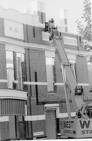
Photograph, Brett Leslie, Bull & Mouth Hotel Demolition in 1985, 1985
Demolition of the Bull & Mouth Hotel Main Street Stawell in 1985 hotels -
 Stawell Historical Society Inc
Newspaper, Weighbridge building Demoilition in Lower Main Street -- Newspaper article
Newspaper article re demolition of weighbridge in Lower Main Streetstawell transport -
Port Melbourne Historical & Preservation Society
Photograph - Demolition east wing (finger pier) and construction of truck bay and ramp for Abel Tasman and Spirit of Tasmania, Station Pier, Port Melbourne, Ron Laing, 1986 - 1999
Part of Ron Laing's collection of photographs taken around Port Melbourne over a thirteen year period. Donated to the PMH&PS by the photographer.A set of fifty-three colour photographs c1992 covering the demolition of the east wing or finger pier of Station Pier, and construction of the new truck bay and ramp for the Abel Tasman and Spirit of Tasmania.piers and wharves - station pier, ron laing, tt-line co pty ltd -
Port Melbourne Historical & Preservation Society
Photograph - View from roof of Housing Commission flats off Princes Street, Port Melbourne, Peter Libbis, 1990
Colour photograph taken from top of roof, Housing Commission flats prior to demolition - shows Swallow & Ariell's biscuit factory, Rouse and Princes Streets, and housing in both streets. 1990built environment - industrial, built environment - domestic, swallow & ariell ltd -
 Ballarat Heritage Services
Photograph, Fernleigh Flats, Ballarat, 12/02/2022
Residents of the Fernleigh Flats Retirement village are understood to be well and strong enough to care for themselves and need to be over the age of 55 years. Fernleigh Flats is owned and operated by the Seventh Day Adventist Church. "TO LET, a Brick House, corner of Urquhart and Ripon Streets. Apply Owen Cazaly, Mining Exchange."(Ballarat Star, 16 Aug 1867) "SALE BY AUCTION, Corner of Urquhart and Ripon streets, 07 COMFORTABLE COTTAGE PROPERTY. M'GREGOR BROTHERS, instructed by the owner, Mr Bradbury, who has bought another property, will sell by public auction, on Monday, 16th May, at half-past 12, His six-roomed substantially-built RESIDENCE. The owner has, under his own supervision, spared no expense in making this a most comfortable and convenient dwelling, situated on a quarter of an acre allotment, at the corner of Urqhuart and Ripon streets, high and dry. Garden laid out with choice young fruit trees; ground capable of growing anything. Fowl yard fenced off. making It a most desirable residence. For a family residence or as An investment this is a good opportunity. Inspection invited. Auctioneer, R. M'GREGOR. (Ballarat Star, 12 May 1893.)A retirement village on the corner of Urquhart Street and Ripon Street, Ballarat. The street trees surrounding this property include a number of trees (blue cedar?) and suggest the demolition of an older stately home on this site. fernleigh flats, residences, architecture -
 Ballarat Tramway Museum
Photograph - Black & White Photograph/s, 18/07/1972 12:00:00 AM
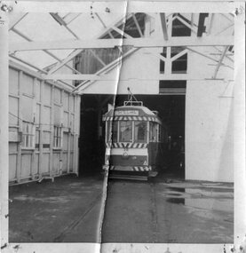
Demonstrates an aspect of the BTPS works on relocating trams ex the SEC depot in the nick of time - as the depot was being demolished. Shows the structure of the depot.Black and White photograph of Ballarat No. 38 inside the SEC depot, following the commencement of the demolition works prior to relocation to the BTPS depot, possibly on 18/7/1972, the day of its relocation.tramways, trams, moving trams, depot, sec depot, btps, tram 38 -
University of Melbourne, Burnley Campus Archives
Plan, Water Supply, c. 1960
A. Plan of existing and proposed new buildings, temporary structures or due for demolition. Water Supply Plan sketched over. B. Sketch plan on tracing paper, further details of water supply.water suplly -
Port Melbourne Historical & Preservation Society
Photograph - Stokes Street, between Farrell and Liardet Streets, Pat Grainger, c. 1993
Photographed around the neighbourhood in the early 1990s.One of three panoramic colour photos taken in the 1990s View of Stokes St homes between Farrell and Liardet Streets prior to demolition in the 1990s. Nott St School is in background on left.built environment - domestic, stokes street -
Canterbury History Group
Photograph - Exposed side door of shop No. 80 Maling Road, Jan Pigot, 27/03/1993 12:00:00 AM
Coloured photograph of the exposed side door of shop No. 80 Maling Road due to the demolition of the Maling Road Theatre. Sign showing the land for lease and a profile of shop No. 80 Maling Roadcanterbury, maling road, shops -
 Lakes Entrance Historical Society
Photograph - Central Hotel Lakes Entrance, Holding M, 2005
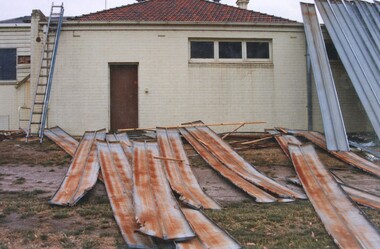
Date made May 2005Colour photograph taken of the rear of the Central Hotel, showing demolition of the building in progress, heavy machinery to knock down walls and a large skip full of bricks and rubble. Lakes Entrance Victoriahotels, machinery -
 Eltham District Historical Society Inc
Photograph, Former Eltham Police Residence, 728 Main Road, Eltham, c.1985, 1985c
This photo is believed to have been taken circa 1985 when the Shire of Eltham Parks and Environment occupied the site. This photo was originally mounted on 3mm MDF fibre board with notes and stickers applied as part of a display on the former Police Residence and now present day Local History Centre, home to Eltham District Historical Society; possibly put together by Harry Gilham during his time as president of the society. Eltham Police Station and Residence: A brief history 1860 Eltham Courthouse built in Main Road, together with an adjoining police residence, office, lock–up and stables. 1959 Police Department purchases a house in Pryor Street to be refurbished as Eltham Police Station 1961 Police in Eltham move into Pryor Street refurbished buildings and office. c.1961-1981 Occupied by Vermin and Noxious Weeds Destruction Section of the Department of Crown Lands and Survey. Former Police Station dragged around to rear of Police Residence (prior to August 1967) to make way for the construction of a driveway and access from Main Road. The building was placed on the site of a former Scullery and modified for Lands Department use. 1981 Shire of Eltham take over management of old Police Residence in Eltham. It remains unoccupied for a period of time whilst its future is discussed in Council. 1981-1985 Used for community job creation scheme 1985 Shire of Eltham Parks and Environment occupy the residence. Council improve the driveway but later add a second rear access from Brougham Street due to the dangerous nature of the Main Road entrance. Also add a rear toilet facility between the Police Residence and former Police Station, which was doubling up as a lunch room. Council also commence discussions to re-establish a replica Police Station. c.1986 November. Former Police Station demolished; believed to have been suffering termite damage. c.1989 After some years of discussion a replica Police Station is built, based on photographs, to act as a lunch room and meeting room for Parks and Environment staff and volunteers doing community service. 1996 Eltham District Historical Society in discussions with Nillumbik Shire Council commisioners throughout the year regarding a home for the Society. A proposal put forward by the Society in October to occupy the former Police Residence. 1997 March. Eltham District Historical Society gains access to former Police Residence. 1998 July 12th. Eltham District Historical Society Inc moves into its Local History Centre, 728 Main Road Eltham (the former Police Residnce built in 1860). 2018 July. Eltham District Historical Society gains access to the replica Police Station for use as part of regular heritage tours for schools and community based groups.Colour printHandwritten in faded blue felt pen ink "No. 1 South wall of 728 & back of house built 1860 [1859]. Demolition of weatherboard extension into yard area"728 main road, eltham, local history centre, parks and environment, police residence, police station, shire of eltham -
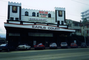 St Kilda Historical Society
Photograph, Earls Court, Upper Esplanade, St Kilda, c.1989
Prior to demolition Earls Court, displaying 'Whelan the Wrecker is here' signcolour photograph unmountedEarls Court. Whelan the wrecker is here. On back: Upper Esplanade is here. -
 Stawell Historical Society Inc
Photograph, Stawell High School before the Bell Tower demolition c1920's -- 2 photos
Stawell High School 1920’s with bell tower before demolition.stawell education -
 City of Ballarat Libraries
Photograph, Ballarat Orphanage, Victoria Street circa 1955
Demolition of Orphanage iron frieze and brackets. It also shows the Polychrome brickwork.ballarat orphange, ballarat, victoria street, iron work, demolition -
 Stawell Historical Society Inc
Photograph, Stawell Technical School -- Part of trade workshops just prior to demolition
Stawell Technical School. Part of trade workshops just prior to demolition.stawell education -
 Whitehorse Historical Society Inc.
Functional object - Bag hooks, Bag hoocks (one metal & one wood handle), Unknown
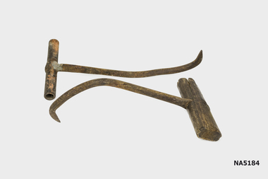
Found under house at 6 Mt Pleasant Road Nunawading following demolition.Example of handmade tools used in wool industry.X 2 bag hooks used to handle bagged material(wool bales?)Nilbag hooks, wool industry -
 Heidelberg Golf Club
Photograph, Heidelberg Golf Club: Clubhouse renovations 1997-98 - Demolition - Southern end, 1997
Heidelberg Golf Club: Clubhouse renovations 1997-98 - Demolition - Southern endColour photograph and caption in albumclubhouse redevelopment 1998, hgc clubhouse 1997, hgc old clubhouse, demolition of old clubhouse -
 Whitehorse Historical Society Inc.
Ceramic - Tile, 1950s
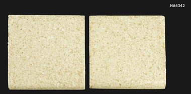
Collected by donor from Site of Tessellated Tile Company buildings at time of demolition.Cream Speckled Tesselated Tile C. 1950. Made by the Australian Tesselated Tile Company, Mitcham.ceramics, earthenware -
Glenelg Shire Council Cultural Collection
Photograph - Photograph - Aerial view from N.W. Port of Portland, 05/03/1971
Port of Portland Authority archives.Front: (no inscriptions) Back: (no inscriptions)port of portland archives, portland harbour -
 Ringwood and District Historical Society
Photograph, Former Ringwood Timer and Trading Co Demolition c1979 and subsequent photos of site
Set of colour photographs taken by Richard Carter, c1979 - Ringwood Timber and Trading Co demolition, and later photos (undated) of the RT&T yard , Charer Street, looking North East and West. -
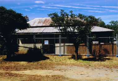 Bendigo Historical Society Inc.
Photograph - POLICE STATION, THORPE STREET, CALIFORNIA GULLY
colour photo : image shows former police station Thorpe Street California Gully, Bendigo, prior to demolition. Timber house, verandah surrounding, iron roof. Building is surrounded by security fencing.organisation, government, california gully police station, bendigo, sandhurst, police station, thorpe street, california gully, demolition