Showing 524 items
matching department of lands
-
 St Kilda Historical Society
Photograph - Photo map, 30/01/1960
... One of a series of photo-maps produced for the Department... produced for the Department of Crown Lands and Survey (1857-1983 ...One of a series of photo-maps produced for the Department of Crown Lands and Survey (1857-1983). For correlation with a current map, and access to other historical photo maps of Victoria, see the Historic Photo-Maps Index published by the Department of Environment, Land, Water and Planning at https://services.land.vic.gov.au/DELWPmaps/historical-photomaps/Black and white aerial photographVic 1091-110 Melbourne & Metropolitan Project Run 23East 30.1.60 Lens 10" 8.200elwood, elsternwick, elsternwick park, ripponlea, st kilda east, caulfield, balaclava, 1960 -
 St Kilda Historical Society
Photograph - Photo map, 30/01/1960
... One of a series of photo-maps produced for the Department... produced for the Department of Crown Lands and Survey (1857-1983 ...One of a series of photo-maps produced for the Department of Crown Lands and Survey (1857-1983). For correlation with a current map, and access to other historical photo maps of Victoria, see the Historic Photo-Maps Index published by the Department of Environment, Land, Water and Planning at https://services.land.vic.gov.au/DELWPmaps/historical-photomaps/Black and white aerial photographVic 1091-1 Melbourne & Metropolitan Project Run 24East 30.1.60 Lens 10" 8.200elwood, elwood beach, elwood park, 1960 -
 St Kilda Historical Society
Photograph - Photo map, 30/01/1960
... One of a series of photo-maps produced for the Department... produced for the Department of Crown Lands and Survey (1857-1983 ...One of a series of photo-maps produced for the Department of Crown Lands and Survey (1857-1983). For correlation with a current map, and access to other historical photo maps of Victoria, see the Historic Photo-Maps Index published by the Department of Environment, Land, Water and Planning at https://services.land.vic.gov.au/DELWPmaps/historical-photomaps/Black and white aerial photographVic 1091-2 Melbourne & Metropolitan Project Run 24East 30.1.60 Lens 10" 8.200elwood, elwood park, elwood beach, elsternwick park, 1960 -
 St Kilda Historical Society
Photograph - Photo map, 3/3/1964
... One of a series of photo-maps produced for the Department... produced for the Department of Crown Lands and Survey (1857-1983 ...One of a series of photo-maps produced for the Department of Crown Lands and Survey (1857-1983). For correlation with a current map, and access to other historical photo maps of Victoria, see the Historic Photo-Maps Index published by the Department of Environment, Land, Water and Planning at https://services.land.vic.gov.au/DELWPmaps/historical-photomaps/Black and white aerial photographVic 1833 Melbourne 1963 Project Run 15 3.3.64 Lens 205 152.70 M/M 5.150 56prahran, fawkner park, south yarra, albert park, 1964 -
 St Kilda Historical Society
Photograph - Photo map, 14/12/1963
... One of a series of photo-maps produced for the Department... produced for the Department of Crown Lands and Survey (1857-1983 ...One of a series of photo-maps produced for the Department of Crown Lands and Survey (1857-1983). For correlation with a current map, and access to other historical photo maps of Victoria, see the Historic Photo-Maps Index published by the Department of Environment, Land, Water and Planning at https://services.land.vic.gov.au/DELWPmaps/historical-photomaps/Black and white aerial photographVic 1807 Melbourne 1963 Project Run 16 14.12.63 Lens 205 152.70 M/M 5.150 179st kilda, prahran, albert park, st kilda east, balaclava, 1963 -
 St Kilda Historical Society
Photograph - Photo map, 14/12/1963
... One of a series of photo-maps produced for the Department... produced for the Department of Crown Lands and Survey (1857-1983 ...One of a series of photo-maps produced for the Department of Crown Lands and Survey (1857-1983). For correlation with a current map, and access to other historical photo maps of Victoria, see the Historic Photo-Maps Index published by the Department of Environment, Land, Water and Planning at https://services.land.vic.gov.au/DELWPmaps/historical-photomaps/Black and white aerial photographVic 1807 Melbourne 1963 Project Run 16 14.12.63 Lens 205 152.70 M/M 5.150 181st kilda cemetery, caulfield north, st kilda east, armadale, malvern, 1963 -
 St Kilda Historical Society
Photograph - Photo map, 14/12/1963
... One of a series of photo-maps produced for the Department... produced for the Department of Crown Lands and Survey (1857-1983 ...One of a series of photo-maps produced for the Department of Crown Lands and Survey (1857-1983). For correlation with a current map, and access to other historical photo maps of Victoria, see the Historic Photo-Maps Index published by the Department of Environment, Land, Water and Planning at https://services.land.vic.gov.au/DELWPmaps/historical-photomaps/Black and white aerial photographVic 1807 Melbourne 1963 Project Run 17 14.12.63 Lens 205 152,70 M/M 5.150 34st kilda, peanut farm, point ormond, st kilda marina, st kilda pier, 1963 -
 St Kilda Historical Society
Photograph - Photo map, 14/12/1963
... One of a series of photo-maps produced for the Department... produced for the Department of Crown Lands and Survey (1857-1983 ...One of a series of photo-maps produced for the Department of Crown Lands and Survey (1857-1983). For correlation with a current map, and access to other historical photo maps of Victoria, see the Historic Photo-Maps Index published by the Department of Environment, Land, Water and Planning at https://services.land.vic.gov.au/DELWPmaps/historical-photomaps/Black and white aerial photographVic 1806 Melbourne 1964 Project Run 18 14.12.63 Lens 205 152.70 M/M 5.150 161elsternwick, elsternwick park, elwood, elwood canal, elwood beach, elwood park, 1963 -
 St Kilda Historical Society
Photograph - Photo map, 12/04/1966
... One of a series of photo-maps produced for the Department... produced for the Department of Crown Lands and Survey (1857-1983 ...One of a series of photo-maps produced for the Department of Crown Lands and Survey (1857-1983). For correlation with a current map, and access to other historical photo maps of Victoria, see the Historic Photo-Maps Index published by the Department of Environment, Land, Water and Planning at https://services.land.vic.gov.au/DELWPmaps/historical-photomaps/Black and white aerial photographVic 1933 Melbourne 1966 Project Run 12 12.4.66 Lens 122 151.75MM 9.800 152st kilda, st kilda pier, st kilda marina, albert park, fawkner park, windsor, south yarra, prahran, st kilda west, middle park, st kilda beach, 1966 -
 St Kilda Historical Society
Photograph - Photo map, 12/04/1966
... One of a series of photo-maps produced for the Department... produced for the Department of Crown Lands and Survey (1857-1983 ...One of a series of photo-maps produced for the Department of Crown Lands and Survey (1857-1983). For correlation with a current map, and access to other historical photo maps of Victoria, see the Historic Photo-Maps Index published by the Department of Environment, Land, Water and Planning at https://services.land.vic.gov.au/DELWPmaps/historical-photomaps/Black and white aerial photographVic 1933 Melbourne 1966 Project Run 12 12.4.66 Lens 122 151.75MM 9.800 154st kilda, st kilda east, balaclava, toorak, amadale, caulfield, south yarra, st kilda botanical gardens, peanut farm, 1966 -
 St Kilda Historical Society
Photograph - Photo map, 12/04/1966
... One of a series of photo-maps produced for the Department... produced for the Department of Crown Lands and Survey (1857-1983 ...One of a series of photo-maps produced for the Department of Crown Lands and Survey (1857-1983). For correlation with a current map, and access to other historical photo maps of Victoria, see the Historic Photo-Maps Index published by the Department of Environment, Land, Water and Planning at https://services.land.vic.gov.au/DELWPmaps/historical-photomaps/Black and white aerial photographVic 1933 Melbourne 1966 Project Run 12 12.4.66 Lens 122 151.75MM 9.800 155 -
 St Kilda Historical Society
Photograph - Photo map, 08/02/1966
... One of a series of photo-maps produced for the Department... produced for the Department of Crown Lands and Survey (1857-1983 ...One of a series of photo-maps produced for the Department of Crown Lands and Survey (1857-1983). For correlation with a current map, and access to other historical photo maps of Victoria, see the Historic Photo-Maps Index published by the Department of Environment, Land, Water and Planning at https://services.land.vic.gov.au/DELWPmaps/historical-photomaps/Black and white aerial photographVic 1916 Melbourne 1966 Project Run 13 E 8.2.66 Lens 122 151.75MM 9.800 113st kilda, st kilda marina, st kilda beach, point ormond, elwood, elwood beach, elwood park, 1966 -
 St Kilda Historical Society
Photograph - Photo map, 08/02/1966
... One of a series of photo-maps produced for the Department... produced for the Department of Crown Lands and Survey (1857-1983 ...One of a series of photo-maps produced for the Department of Crown Lands and Survey (1857-1983). For correlation with a current map, and access to other historical photo maps of Victoria, see the Historic Photo-Maps Index published by the Department of Environment, Land, Water and Planning at https://services.land.vic.gov.au/DELWPmaps/historical-photomaps/Black and white aerial photographVic 1916 Melbourne 1966 Project Run 13 E 8.2.66 Lens 122 151.75MM 9.800 111st kilda, balaclava, caulfield, caulfield north, st kilda east, elsternwick, elsterwick park, elwood park, elwood canal, elwood beach, ripponlea, 1966 -
 St Kilda Historical Society
Photograph - Photo map, 11/01/1968
... One of a series of photo-maps produced for the Department... produced for the Department of Crown Lands and Survey (1857-1983 ...One of a series of photo-maps produced for the Department of Crown Lands and Survey (1857-1983). For correlation with a current map, and access to other historical photo maps of Victoria, see the Historic Photo-Maps Index published by the Department of Environment, Land, Water and Planning at https://services.land.vic.gov.au/DELWPmaps/historical-photomaps/Black and white aerial photographVic 2132 State Aerial Survey Melbourne 1968 Proj Run 27E 11.1.68 5100 ASL 65caulfield north, caulfield park, armadale, malvern, 1968 -
 St Kilda Historical Society
Photograph - Photo map, 11/01/1968
... One of a series of photo-maps produced for the Department... produced for the Department of Crown Lands and Survey (1857-1983 ...One of a series of photo-maps produced for the Department of Crown Lands and Survey (1857-1983). For correlation with a current map, and access to other historical photo maps of Victoria, see the Historic Photo-Maps Index published by the Department of Environment, Land, Water and Planning at https://services.land.vic.gov.au/DELWPmaps/historical-photomaps/Black and white aerial photographVic 2132 State Aerial Survey Melbourne 1968 Proj Run 27E 11.1.68 5100 ASL 67st kilda east, st kilda cemetery, caulfield north, alma park, balaclava, armadale, 1968 -
 St Kilda Historical Society
Photograph - Photo map, 13/01/1968
... One of a series of photo-maps produced for the Department... produced for the Department of Crown Lands and Survey (1857-1983 ...One of a series of photo-maps produced for the Department of Crown Lands and Survey (1857-1983). For correlation with a current map, and access to other historical photo maps of Victoria, see the Historic Photo-Maps Index published by the Department of Environment, Land, Water and Planning at https://services.land.vic.gov.au/DELWPmaps/historical-photomaps/Black and white aerial photograph2138 State Aerial Survey Melbourne 1968 Proj. Run 26 13.1.68 5100 ASL 203st kilda west, albert park, fawkner park, south yarra, prahran, windsor, 1968 -
 St Kilda Historical Society
Photograph - Photo map, 11/01/1968
... One of a series of photo-maps produced for the Department... produced for the Department of Crown Lands and Survey (1857-1983 ...One of a series of photo-maps produced for the Department of Crown Lands and Survey (1857-1983). For correlation with a current map, and access to other historical photo maps of Victoria, see the Historic Photo-Maps Index published by the Department of Environment, Land, Water and Planning at https://services.land.vic.gov.au/DELWPmaps/historical-photomaps/Black and white aerial photographVic 2132 State Aerial Survey Melbourne 1968 Proj. Run 27E 11.1.68 5100 ASL 69st kilda, albert park, st kilda east, st kilda beach, alma park, windsor, prahran, 1968 -
 St Kilda Historical Society
Photograph - Photo map, 11/01/1968
... One of a series of photo-maps produced for the Department... produced for the Department of Crown Lands and Survey (1857-1983 ...One of a series of photo-maps produced for the Department of Crown Lands and Survey (1857-1983). For correlation with a current map, and access to other historical photo maps of Victoria, see the Historic Photo-Maps Index published by the Department of Environment, Land, Water and Planning at https://services.land.vic.gov.au/DELWPmaps/historical-photomaps/Black and white aerial photographVic 2132 State Aerial Survey Melbourne 1968 Proj. Run 28E 11.1.68 5100 ASL 81st kilda, balaclava, st kilda east, ripponlea, elwood, elsternwick, caulfield, st kilda botanical gardens, 1968 -
 St Kilda Historical Society
Photograph - Photo map, 11/01/1968
... One of a series of photo-maps produced for the Department... produced for the Department of Crown Lands and Survey (1857-1983 ...One of a series of photo-maps produced for the Department of Crown Lands and Survey (1857-1983). For correlation with a current map, and access to other historical photo maps of Victoria, see the Historic Photo-Maps Index published by the Department of Environment, Land, Water and Planning at https://services.land.vic.gov.au/DELWPmaps/historical-photomaps/Black and white aerial photographVic 2132 State Aerial Survey Melbourne 1968 Proj. Run 29E 11.1.68 5100 ASL 194elwood, elwood beach, elwood park, elsternwick park, ripponlea, elwood canal, balaclava, st kilda, 1968 -
 St Kilda Historical Society
Photograph - Photo map, 11/01/1968
... One of a series of photo-maps produced for the Department... produced for the Department of Crown Lands and Survey (1857-1983 ...One of a series of photo-maps produced for the Department of Crown Lands and Survey (1857-1983). For correlation with a current map, and access to other historical photo maps of Victoria, see the Historic Photo-Maps Index published by the Department of Environment, Land, Water and Planning at https://services.land.vic.gov.au/DELWPmaps/historical-photomaps/Black and white aerial photographVic 2132 State Aerial Survey Melbourne 1968 Proj. Run 27E 11.1.68 5100 ASLst kilda, st kilda west, st kilda pier, catani gardens, st kilda beach, albert park, 1968 -
 St Kilda Historical Society
Photograph - Photo map, 11/01/1968
... One of a series of photo-maps produced for the Department... produced for the Department of Crown Lands and Survey (1857-1983 ...One of a series of photo-maps produced for the Department of Crown Lands and Survey (1857-1983). For correlation with a current map, and access to other historical photo maps of Victoria, see the Historic Photo-Maps Index published by the Department of Environment, Land, Water and Planning at https://services.land.vic.gov.au/DELWPmaps/historical-photomaps/Black and white aerial photographVic 2132 State Aerial Survey Melbourne 1968 Proj. Run 29E 11.1.68 5100 ASL 196elwood, elwood park, elwood canal, elwood beach, st kilda marina, mc moran reserve, point ormond, 1968 -
 St Kilda Historical Society
Photograph - Photo map, 14/12/1963
... One of a series of photo-maps produced for the Department... produced for the Department of Crown Lands and Survey (1857-1983 ...One of a series of photo-maps produced for the Department of Crown Lands and Survey (1857-1983). For correlation with a current map, and access to other historical photo maps of Victoria, see the Historic Photo-Maps Index published by the Department of Environment, Land, Water and Planning at https://services.land.vic.gov.au/DELWPmaps/historical-photomaps/Black and white aerial photographVic 1807 Melbourne 1963 Project Run 17 14.12.63 Lens 205 152.70 M/M 5.150 36st kilda, st kilda botanical gardens, balaclava, st kilda east, elwood canal, ripponlea, caulfield north, elwood, caulfield, 1963 -
 St Kilda Historical Society
Photograph - Photo map, 14/12/1963
... One of a series of photo-maps produced for the Department... produced for the Department of Crown Lands and Survey (1857-1983 ...One of a series of photo-maps produced for the Department of Crown Lands and Survey (1857-1983). For correlation with a current map, and access to other historical photo maps of Victoria, see the Historic Photo-Maps Index published by the Department of Environment, Land, Water and Planning at https://services.land.vic.gov.au/DELWPmaps/historical-photomaps/Black and white aerial photographVic 1807 Melbourne 1963 Project Run 16 14.12.1963 Lens 205 152.70 M/M 5.150 177st kilda, st kilda pier, catani gardens, middle park, albert park, st kilda west, st kilda beach, 1963 -
 Bendigo Historical Society Inc.
Map - FRED COWIE COLLECTION: AERIAL MAPS OF HEATHCOTE/EPPALOCK, 28-9-60
... prepared by Department of Crown Lands and Survey from photographs... by Department of Crown Lands and Survey from photographs taken in 1960 ...Map, Heathcote C3, Aerial Survey of Victoria, Photo-map prepared by Department of Crown Lands and Survey from photographs taken in 1960.Copied photographically at the Central Plan Office. Date 28-9 60, C.P.O.Neg. No.21588.Campaspe River, Coliban River. Flower Hill. Fred Cowie,46 McIvor Rd.Bendigo (Not located 29.9.2022)Central Plan Office.map, heathcote, fred cowie -
 Stawell Historical Society Inc
Book - Report, Grampians National Park Draft Management Plan, 1985
... . A Division of the department of Conservation, Forest and Lands.... A Division of the department of Conservation, Forest and Lands $5 ...For Public comment to National Park Service, Victoria. A Division of the department of Conservation, Forest and LandsSoft Cover with B/W Photo of aerial view of ranges of Grampians. Black taped Spine binding.$5 Barry Clugston -
 Bendigo Historical Society Inc.
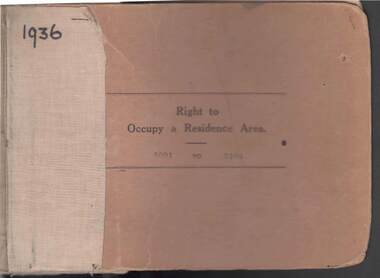
Book - RIGHT TO OCCUPY RESIDENCE AREA COLLECTION: REGISTER 1936
... transferred to /one stub shows Department of Lands and Survey note... to /one stub shows Department of Lands and Survey note on Bendigo ...COLLECTION OF RIGHT TO OCCUPY A RESIDENCE AREA -LAND (RESIDENCE AREAS ) Act 1935 / thick cardboard book -cloth and string binding / written on front in texter '1936' / numbers 5001 to 5100 / inside - stubs of documents showing Granted to , of, period, Date of Right , Description of Land , Allotment, Section, City, Town , Borough , Township of , Parish of , Authorised Person . Rubber stamps show The interest of this Right has been transferred to /one stub shows Department of Lands and Survey note on Bendigo Historical Society Catalogue Sheet dated 12.6.2008 All buts completed and original application forms removed. Note -forms were originally in triplicate on one page with serrations for removal of two parts; butts remain .Residence areas in Central Goldfields.Bendigo City Council - Acquisition 1990organization, government, official -
Bendigo Historical Society Inc.
Map - BENDIGO, 1916
... at the Department of Lands and Survey, Melbourne. 1916. Scale : Two miles... at the Department of Lands and Survey, Melbourne. 1916. Scale : Two miles ...Map. Bendigo, Gunbower, Gladstone, Talbot, Dalhousie, Rodney, Jarklan, Calivil, Hayanmi, Mitiamo, Wanurp, Pannoobamawm, Bamawm, Millewa, Ballendella, Janiember West, Janiember East, Pompapiel, Talambe, Dingee, Milloo, Pannoomilloo, Rochester West, Yarrayne, Salisbury, Yallook, Tandarra, Kamarooka, Warragamba, Diggorra, Minto, Bridgewater, Yarraberb, Neilborough, Whirrakee, Egerton, Elmore, Nolan, Goornong, Bagshot, Huntly, Derby, Leichardt, Nerring, Tarnagulla, Woodstock, Marong, Sandhurst, Wellsford, Bendigo, Axedale, Strathfieldsaye, Eppalock, Kimbolton, Lyell, Sedgwick, Mandurang, Lockwood, Ravenswood, Shelbourne, Laanecoorie. Price 3/-. Smaller map of State of Victoria. Lithographed at the Department of Lands and Survey, Melbourne. 1916. Scale : Two miles to one inch. Map was in book form. (number 62 in map cupboard 1)map, bendigo, bendigo -
 Port Melbourne Historical & Preservation Society
Map - Track, Sandridge to Melbourne, 1840
... Sandridge (Liardet's Beach), 1840. Originals with Lands Department... Beach), 1840. Originals with Lands Department, Melbourne ...Bromide of surveyor's sketch of the track to Melbourne from Sandridge (Liardet's Beach), 1840. Originals with Lands Department, Melbourne. (possibly the work of William Wedge DARKE?)Slight processing stain upper right, '6' on backbusiness and traders - hotels, william wedge darke, piers and wharves -
Warrnambool and District Historical Society Inc.
Correspondence (Rose Park), 1940s
... the proposal in the 1940s by the Victorian Department of Lands... by the Victorian Department of Lands and Survey to acquire sections ...These are four letters and a document regarding the proposal in the 1940s by the Victorian Department of Lands and Survey to acquire sections of the property, Rose Park, to establish several Soldier Settlement farms. Rose Park, near Willatook, was owned by Stan Baulch (1897-1980), the son of Samuel and Eliza Baulch. Samuel Baulch had acquired the property of Dunmore, between Macarthur and Hawkesdale, in 1893 and Stan had inherited portion of this property after his father’s death. He named his portion Rose Park. The Soldier Settlement Commission wanted to acquire 1500 acres of Rose Park but Stan Baulch argued successfully that the management of his farm could not withstand the loss of so much land and eventually 300 acres of Rose Park land was sold for closer settlement. Stan Baulch was a prominent member of the Warrnambool and District Historical Society for many years and contributed many articles and booklets on local historical matters. This correspondence is of interest as an example of the establishment of Soldier Settlement farms in Victoria post World War Two and the difficulties faced by some property owners opposed to the acquisition of their land. These items will be useful for research. .1 A six-page letter written in pencil .2 A two page letter in black typing ( contents as in .1 above) .3 A one page letter, typed, with a handwritten signature .4 A sheet of paper containing a statement re purchase of land with some inserted handwritten material .5 A two page letter with handwritten material baulch family, western district, victoria, history of warrnambool -
 Bacchus Marsh & District Historical Society
Map, Bacchus Marsh Region Parish Plans: Folded set of maps
... Set of Victorian Lands Department Parish Plans covering... Interim Record Set of Victorian Lands Department Parish Plans ...Set of Victorian Lands Department Parish Plans covering the township of Bacchus Marsh and surrounding districts. Folded. BMDHS Location: AR/SU27/D2: Map Drawersmaps bacchus marsh region, bacchus marsh victoria maps, interim record