Showing 802 items matching "engineering - roads"
-
 Eltham District Historical Society Inc
Photograph, Old Bridge, Kaylock's Crossing, Brougham Street, Eltham, c.1895
Brougham Street was created in Josiah Holloway's 1851 subdivision of Little Eltham. It was one of several east-west streets shown on the subdivision plan as crossing the Diamond Creek. The western part was named Wellington Street on the subdivision plan but was later changed to conform with the name of the eastern part as acknowledgement of the continuity of the street. It is not known when the first bridge was constructed in Brougham Street however it was certainly mentioned at Council’s meeting of 2 June 1884 as being in a dangerous state of repair. This photo (c.1895) of an old bridge shows a very low-level simple log girder bridge crossing the creek at a right angle and so the approaches involved bends in the road alignment. This bridge was generally known as Kaylocks Bridge or Kaylock’s Crossing after the owner of the adjoining land. It was most likely built from around the mid-1850s, or a crossing of some fashion established as Richard George Kaylock, butcher of Little Eltham and his wife Emily Ann settled there in 1854. His property was in Wellington Street (now Brougham Street) and apparently extended across the Diamond Creek. The land on the western side of the creek was farmed, the house being on the eastern side. Kaylock's Bridge formed part of the original coach road to Eltham and in 1922 was described as an "old rustic bridge". Its low level and insubstantial construction made it susceptible to flood damage, necessitating frequent closures until repairs could be carried out. In September 1922, Council called for tenders for a new timber bridge to be constructed at Kaylock’s crossing. An engineering assessment carried out for the Council by Macleod Consulting at the time of the replacement suggested that the construction details indicate that it was in the 1900s, however this dating could possibly have been the result of numerous repairs undertaken over the years to flood damage. The tender was awarded to Mr Weller of Kangaroo Ground who commenced work in February 1923 on a higher-level timber trestle bridge. Work was slowed due to illness of the contractor and the accidental death of a man in March 1923 following the collapse of the bank after he had jumped into a hole that had just been blasted. The bridge was completed around July 1923 at which point the old structure was pulled up, marking what was described in the ‘Advertiser’ newspaper as the passing of an old and well-loved landmark in the district. In April 1924 the approach to Kaylocks bridge was washed away during the heavy flooding that destroyed the Main Road bridge. The western side was repaired, and an extra span was added to the eastern side using timber from the destroyed Main Road bridge. The bridge was again severely damaged four months later in August 1924 When a lack of finances delayed repairs to the Bridge Street bridge in 1931 (also referred to as Obelisk Bridge at the time), traffic had to detour via Brougham Street for some time. Local residents feared that the Bridge Street bridge might never reopen. Kaylocks Bridge was constantly subject to damage by floods. In the 1934 flood it was submerged by two feet of water. In more recent times the bridge was again severely damaged by flooding and repairs made. A new bridge and adjoining footbridge were constructed in 2009. Part of a slide show presentation "Bridges & Waterways of the Shire" by Russell Yeoman to the 13 September 1989 Society meeting. The presentation included slides of historic photos from the Shire of Eltham Pioneers collections as well as several recent views.Photo of earliest known crossing of the Diamond Creek at brougham StreetPostcard photo printbrougham street, eltham, wellington street, kaylocks bridge, bridge, diamond creek (creek) -
 Doncaster RSL Sub Branch
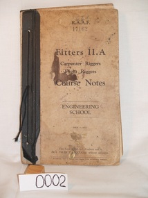
Foolscap Size Book, RAAF Course Notes. Fitters II.A Carpenters and Flight Riggers. Issue 5 - 1943
RAAF Engineering School World War IIHard Cover Book. H) 330 x W) 205 x T)18. Dirty buff with black binding.RAAF Course Notes, Fitters II.A Carpenter Riggers Flight Riggers Engineering School Issue 5--1943 -
 Warrnambool and District Historical Society Inc.
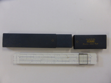
Instruments, Slide Rule, C1955
A slide rule is an instrument which is used to carry out mathematical calculations. William Oughtred is credited with its invention in 1621, however many others including Isaac Newton have made improvements or modifications over the years. From 1625 to 1800 there were approximately 40 different styles brought forward. with the following 100 years sees over 250 designs created.There have been different versions and modifications to suit scientific, mathematical and engineering requirements. It is interesting to note that many of the buildings of the 19th and 20th centuries have been designed with the use of slide rules. Their use has declined in the last 25-30 years with the advent of computers and specialist calculators.While not directly linked in any way to the history of Warrnambool, this slide rule would have been a item in use by students doing maths at upper secondary level as well as other applications which would make it a familiar object to many people.Coated bamboo with sliding metal framed glass panel or cursor . The bamboo is in three sections with the middle section movable. It is marked in various graduated measurements mainly in dark blue but with some in green and red.It is inside a dark grey rectangular box with a slide off lid on one end.There is a celluloid panel on the back with a conversion table printed on it. There is an accompanying 67 page manual with a pale green cover with black text. On slide rule:Sun Hemmi Japan No 2664S On box: Sun Hemmi Japan No 2664S warrnambool, hemmi slide rule, bamboo slide rule -
 Warrnambool and District Historical Society Inc.
Note Book, Engineering Drawings, 1919-21
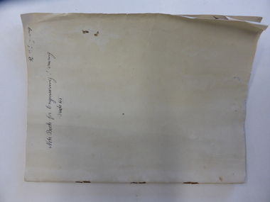
This note book contains handwritten material by Ron Uebergang – notes on engineering drawings prepared for a class at Warrnambool Technical School 1919-1921. Ronald Uebergang (1903-1971) was the son of Ernest and Mary Uebergang. He attended Allansford State School and Warrnambool Technical School and spent his working life dairying and raising cattle on the family property, Hopkins Hill, at Allansford, about nine kilometres east of Warrnambool. He was mechanically minded, fond of music and dancing and a keen photographer. These notes are of interest as they were compiled by Ron Uebergang when he was a student at Warrnambool Technical School 1919-21. The Uebergang families were pioneering settlers in the Allansford area and have been prominent farmers in the area from the 1850s on. The notes also are a good example of the work done by students at Warrnambool Technical School in the 1920s. This is a hand-made book of 22 pages with notes on engineering drawings by Ron Uebergang handwritten in black ink. There is tissue paper inserted between some of the pages. There are several drawings and equations in with the handwritten material. There is some silver fish damage on the front cover. Front Cover: ‘R. Uebergang’ ‘Note Book for Engineering Drawing Grade 3’ ronald uebergang, warrnambool technical school, history of allansford, history of warrnambool -
 Warrnambool and District Historical Society Inc.
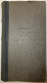
Document - Ledger: Shire of Warrnambool. Engineers Correspondence October 1937 -July 1939, Mid 1930's
The letters contained within this ledger provide an overview of correspondence which occurred around matters such as roadmaking and maintenance.Provides a detailed record of correspondence relating to engineering matters in the shire and surrounds and also a comprehensive list of organisations associated with this work.Dull grey green card with dark green cloth spine binding. Engineers' Correspondence Oct 15th 1937 - July 17th 1939 in black ink. Contains index at front and pink duplicate copies of letters written Inside front cover on paper stamp: Arnall & Jackson, Printers, lithographers, bookbinders, publishers, manufacturing stationers. 428 Collins St Melbourne. Repeat order No. B 92120 warrnambool, warrnambool shire, warrnambool shire engineer, j crwaley, road works, bridges, bitumen roads, shire correspondence, 1937-1939 -
 Warrnambool and District Historical Society Inc.
Document - Ledger: Correspondence and reports Country Roads Board , Shire of Warrnambool 1914-1925, Circa 1914
The letters contained within this ledger provide an overview of correspondence which occurred around matters such as roadmaking and maintenanceProvides a detailed record of correspondence relating to engineering matters in the shire and surrounds and also a comprehensive list of organisations associated with this work.Dark blue watermarked cover with fawn suede binding and corners. Spine has three coloured rectangles with the following in each: Correspondence and reports, Country Roads Board and Shire of Warrnambool. There is an index at the front and the ledger contains copies of correspondence relating to roads, maintenance and infrastructure.Inserted in ledger is1) typed invoice from The Government of Victoria to Shire of Warrnambool for 1915/16, 2) Original of two pages showing list of contracts on Garvoc Laang Road. Arnall and Jackson, Engravers and Lithographers. Printers and Manufacturing stationers 478 Collins Street, Melbourne. No B 22065 23/09/14. warrnambool, warrnambool shire engineer, shire correspondence, crawley, road works, bridges, bitumen roads, 1914-1925, country roads board -
 Eltham District Historical Society Inc
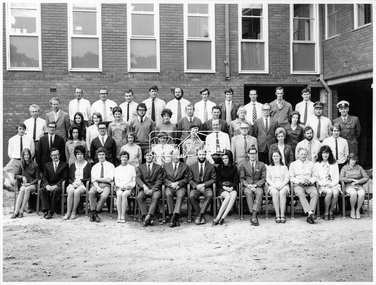
Photograph, Hugh Fisher, Eltham Shire Council Staff, Shire Centenary Anniversary, 6 April 1971
Formal photograph of group of men and women employed by the Shire of Eltham, to commemorate the Shire Centenary April 1971. Photograph taken at the rear of the Council Offices, Main Road, Eltham Includes Eltham Shire Council Staff List and Phone Numbers, 1971 1971 Eltham Shire Council Staff Photo (SEPP_4050 and SEPP_4051) L-R Back Row: N. Stuart (Engineering), N. Campbell (Engineering), W. Oakley (Engineering), R. McIldowie (Engineering), D. Welch (Engineering), G. Pullen (Accounts), J. Bleazby (Rates), P. Sturtevent (Engineering), B. Hill (Engineering), F. Harrington (Engineering) Third Row: C. Harris (Building), M. Van Ewijk (Accounts), Miss C. Casella (Administration), Miss D. Curran (Rates), M. Howard (Administration), Dennis McKay (Engineering), Mrs L. Crockett (Accounts), A. Liepa (Engineering), G. Newton (Building), Mrs N. Davis (Administration), I. Leach (Health), Mrs F. Conyers (Rates), B. Wright (ranger), I. Caig (Traffic By-Laws Officer) Second Row: J. Constable (Accounts), J. Parsons (Health), Mrs J. Baker (Health), P. Hoare (Engineering), Miss R. Spearman (Rates), D. Golder (Engineering), Mrs R. Cox (Administration), H. Masefield (Fire Proper Officer), A. Birch (Engineering), Sister L. Cameron (Health), Russell Yeoman (Engineering), T. Phyland (Engineering) Front Row (seated): Miss D. Vreulink (Administration), D. Lovatt (Health), Mrs H. Dixson (Accounts), M. Fowler (Rates), Mrs L. Harris (Administration), C. Gaudion (Health), M. Watson (Shire Secretary), A. Roberts (Administration), Miss J. Featherby (Engineering), M. Verhoeven (Engineering), Mrs M. Lethlean (Engineering), I. McDonald (Rate Collector), Mrs W. Klooster (Engineering), Mrs C. Bell (Engineering) Absent: John McDonald (Shire Engineer) This photo forms part of a collection of photographs gathered by the Shire of Eltham for their centenary project book,"Pioneers and Painters: 100 years of the Shire of Eltham" by Alan Marshall (1971). The collection of over 500 images is held in partnership between Eltham District Historical Society and Yarra Plenty Regional Library (Eltham Library) and is now formally known as the 'The Shire of Eltham Pioneers Photograph Collection.' It is significant in being the first community sourced collection representing the places and people of the Shire's first one hundred years.Digital image Print Foolscap page typedInscribed A2207A (SEPP_4050) 2nd version inscribed A2207B (SEPP_4051)a. birch, a. liepa, a. roberts, b. hill, b. wright, c. gaudion, c. harris, council, council staff, council-staff, d. golder, d. lovatt, d. welch, dennis mckay, eltham-shire-council, f. harrington, g. newton, g. pullen, h. masefield, i. caig, i. leach, i. mcdonald, j. bleazby, j. constable, j. parsons, john mcdonald, m. fowler, m. howard, m. van ewijk, m. verhoeven, m. watson, miss c. casella, miss d. curran, miss d. vreulink, miss j. featherby, miss r. spearman, mrs c. bell, mrs f. conyers, mrs h. dixson, mrs j. baker, mrs l. crockett, mrs l. harris, mrs m. lethlean, mrs n. davis, mrs r. cox, mrs w. klooster, n. campbell, n. stuart, p. hoare, p. sturtevent, r. mcildowie, russell yeoman, shire of eltham centenary, shire of eltham pioneers photograph collection, sister l. cameron, t. phyland, w. oakley -
 Eltham District Historical Society Inc
Photograph, Hugh Fisher, Eltham Shire Council Staff, Shire Centenary Anniversary, 6 April 1971
Formal photograph of group of men and women employed by the Shire of Eltham, to commemorate the Shire Centenary 6 April 1971. Photograph taken at the rear of the Council Offices, Main Road, Eltham 1971 Eltham Shire Council Staff Photo (SEPP_4050 and SEPP_40511) L-R Back Row: N. Stuart (Engineering), N. Campbell (Engineering), W. Oakley (Engineering), R. McIldowie (Engineering), D. Welch (Engineering), G. Pullen (Accounts), J. Bleazby (Rates), P. Sturtevent (Engineering), B. Hill (Engineering), F. Harrington (Engineering) Third Row: C. Harris (Building), M. Van Ewijk (Accounts), Miss C. Casella (Administration), Miss D. Curran (Rates), M. Howard (Administration), Dennis McKay (Engineering), Mrs L. Crockett (Accounts), A. Liepa (Engineering), G. Newton (Building), Mrs N. Davis (Administration), I. Leach (Health), Mrs F. Conyers (Rates), B. Wright (ranger), I. Caig (Traffic By-Laws Officer) Second Row: J. Constable (Accounts), J. Parsons (Health), Mrs J. Baker (Health), P. Hoare (Engineering), Miss R. Spearman (Rates), D. Golder (Engineering), Mrs R. Cox (Administration), H. Masefield (Fire Proper Officer), A. Birch (Engineering), Sister L. Cameron (Health), Russell Yeoman (Engineering), T. Phyland (Engineering) Front Row (seated): Miss D. Vreulink (Administration), D. Lovatt (Health), Mrs H. Dixson (Accounts), M. Fowler (Rates), Mrs L. Harris (Administration), C. Gaudion (Health), M. Watson (Shire Secretary), A. Roberts (Administration), Miss J. Featherby (Engineering), M. Verhoeven (Engineering), Mrs M. Lethlean (Engineering), I. McDonald (Rate Collector), Mrs W. Klooster (Engineering), Mrs C. Bell (Engineering) Absent: John McDonald (Shire Engineer) This photo forms part of a collection of photographs gathered by the Shire of Eltham for their centenary project book, "Pioneers and Painters: 100 years of the Shire of Eltham" by Alan Marshall (1971). The collection of over 500 images is held in partnership between Eltham District Historical Society and Yarra Plenty Regional Library (Eltham Library) and is now formally known as 'The Shire of Eltham Pioneers Photograph Collection.' It is significant in being the first community sourced collection representing the places and people of the Shire's first one hundred years.Digital image Print 20 x 25 cmInscribed A2207A (SEPP_4050) 2nd version inscribed A2207B (SEPP_4051)a. birch, a. liepa, a. roberts, b. hill, b. wright, c. gaudion, c. harris, council, council staff, council-staff, d. golder, d. lovatt, d. welch, dennis mckay, eltham-shire-council, f. harrington, g. newton, g. pullen, h. masefield, i. caig, i. leach, i. mcdonald, j. bleazby, j. constable, j. parsons, john mcdonald, m. fowler, m. howard, m. van ewijk, m. verhoeven, m. watson, miss c. casella, miss d. curran, miss d. vreulink, miss j. featherby, miss r. spearman, mrs c. bell, mrs f. conyers, mrs h. dixson, mrs j. baker, mrs l. crockett, mrs l. harris, mrs m. lethlean, mrs n. davis, mrs r. cox, mrs w. klooster, n. campbell, n. stuart, p. hoare, p. sturtevent, r. mcildowie, russell yeoman, shire of eltham centenary, shire of eltham pioneers photograph collection, sister l. cameron, t. phyland, w. oakley -
 Ringwood and District Historical Society
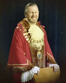
Photo of Mayor Gerald Richard Smart in mayoral robes, Photo of Ringwood Mayor Gerald Richard Smart in mayoral robes
The colour negative appears to be an official photo arranged by the City of Ringwood Council.Gerald Smart was mayor in 1973/74 and 1976/77 for the City of Ringwood. He also served as a Councillor from 1967/68 until 1981/82. Married Sandra, who also served as Mayoress for Cr Pat Palmer. Gerald was instrumental in getting the Wyrenna-based local radio station, ECB-FM, off the ground. Other information:- SMART, Gerald Richard George 1967-73, Mayor 1973-74, Chartered Engineer. Melbourne University, R.M.I.T., Diploma of Radio Engineering. Son of Walter and Doris Smart. Married with one son. Cricket, tennis, golf, spearfishing, chess, table tennis, photography (8mm, 35mm, stills, music.) Theatre - Melbourne University, Emerald Hill Repertory Company. Radio - Music session on 3XY. Television - 'Consider Your Verdict', character parts. President Ringwood Arts and Crafts Society Honorary Secretary of Television Society of Australia Patron, Ringwood Swimming and Life Saving Club President Ringwood District Scouting Association Executive Committee Member of Municipal Association of Victoria Formed ECB-FM +Additional Keywords: Refer to the "Mayor" envelope, registration no. 3932, for further information. -
 Ringwood and District Historical Society
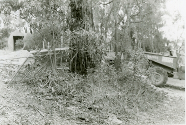
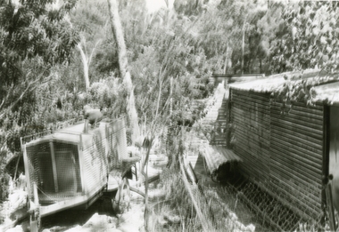
Photographs, 1979-80 MMBW pipe line project at Hubbard Reserve, North Ringwood � Boring mole pit
E560 N5 Dec 1979 A43 Boring mole pit near big box tree in 39 Burlock Avenue backyard Part of a 43-photo record of the MMBW�s engineering feat in drilling a 12 inch pipe line up to 40 feet deep through rock hardened by volcanic action associated with geological fault that occurs along the line. The work took place from October 1979 to May 1980 on the southern boundary of Hubbard Reserve, North Ringwood. The collection was presented to the Ringwood Historical Research Group by J Clarke on 9th June 1980. -
 Ringwood and District Historical Society
Photographs, 1979-80 MMBW pipe line project at Hubbard Reserve, North Ringwood � Back-hoe at pit
E560 N6 Dec 1979 A43 The back-hoe works on the beginnings of pit in 39 Burlock Avenue backyard Part of a 43-photo record of the MMBW�s engineering feat in drilling a 12 inch pipe line up to 40 feet deep through rock hardened by volcanic action associated with geological fault that occurs along the line. The work took place from October 1979 to May 1980 on the southern boundary of Hubbard Reserve, North Ringwood. The collection was presented to the Ringwood Historical Research Group by J Clarke on 9th June 1980. -
 Ringwood and District Historical Society
Photographs, 1979-80 MMBW pipe line project at Hubbard Reserve, North Ringwood � Cover of mole pit
E560 N24 Jan 1980 A43 Cover of mole pit near big box tree in 39 Burlock Avenue backyard Part of a 43-photo record of the MMBW�s engineering feat in drilling a 12 inch pipe line up to 40 feet deep through rock hardened by volcanic action associated with geological fault that occurs along the line. The work took place from October 1979 to May 1980 on the southern boundary of Hubbard Reserve, North Ringwood. The collection was presented to the Ringwood Historical Research Group by J Clarke on 9th June 1980. -
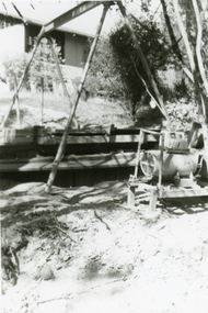
 Ringwood and District Historical Society
Photographs, 1979-80 MMBW pipe line project at Hubbard Reserve, North Ringwood � Compressor unit in backyard
Part of a 43-photo record of the MMBW�s engineering feat in drilling a 12 inch pipe line up to 40 feet deep through rock hardened by volcanic action associated with geological fault that occurs along the line. The work took place from October 1979 to May 1980 on the southern boundary of Hubbard Reserve, North Ringwood. The collection was presented to the Ringwood Historical Research Group by J Clarke on 9th June 1980.E560 N23 Jan 1980 A43 Compressor unit in backyard of 39 Burlock Avenue -
 Ringwood and District Historical Society
Photographs, 1979-80 MMBW pipe line project at Hubbard Reserve, North Ringwood � Work on boring mole pit
Part of a 43-photo record of the MMBW�s engineering feat in drilling a 12 inch pipe line up to 40 feet deep through rock hardened by volcanic action associated with geological fault that occurs along the line. The work took place from October 1979 to May 1980 on the southern boundary of Hubbard Reserve, North Ringwood. The collection was presented to the Ringwood Historical Research Group by J Clarke on 9th June 1980.E560 N22Jan 1980 A43 Work on mole boring pit in 39 Burlock Avenue backyard -
 Ringwood and District Historical Society
Photographs, 1979-80 MMBW pipe line project at Hubbard Reserve, North Ringwood � Filling at 29 Burlock Avenue
Part of a 43-photo record of the MMBW�s engineering feat in drilling a 12 inch pipe line up to 40 feet deep through rock hardened by volcanic action associated with geological fault that occurs along the line. The work took place from October 1979 to May 1980 on the southern boundary of Hubbard Reserve, North Ringwood. The collection was presented to the Ringwood Historical Research Group by J Clarke on 9th June 1980.E560 N10 Dec 1979 A43 Filling at 29 Burlock Avenue -
 Ringwood and District Historical Society
Photographs, 1979-80 MMBW pipe line project at Hubbard Reserve, North Ringwood � Filling behind 29 Burlock Avenue just off sewer line
Part of a 43-photo record of the MMBW�s engineering feat in drilling a 12 inch pipe line up to 40 feet deep through rock hardened by volcanic action associated with geological fault that occurs along the line. The work took place from October 1979 to May 1980 on the southern boundary of Hubbard Reserve, North Ringwood. The collection was presented to the Ringwood Historical Research Group by J Clarke on 9th June 1980.E560 N9 Dec 1979 A43 Filling behind 29 Burlock Avenue just off sewer line -
 Ringwood and District Historical Society
Photographs, 1979-80 MMBW pipe line project at Hubbard Reserve, North Ringwood � Filling at 29 Burlock Avenue
Part of a 43-photo record of the MMBW�s engineering feat in drilling a 12 inch pipe line up to 40 feet deep through rock hardened by volcanic action associated with geological fault that occurs along the line. The work took place from October 1979 to May 1980 on the southern boundary of Hubbard Reserve, North Ringwood. The collection was presented to the Ringwood Historical Research Group by J Clarke on 9th June 1980.E560 N11 Dec 1979 A43 Filling at 29 Burlock Avenue -
 Ringwood and District Historical Society
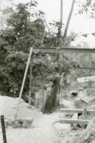
Photographs, 1979-80 MMBW pipe line project at Hubbard Reserve, North Ringwood � Closeup of revolving airwinch near Hibberd's house
Part of a 43-photo record of the MMBW�s engineering feat in drilling a 12 inch pipe line up to 40 feet deep through rock hardened by volcanic action associated with geological fault that occurs along the line. The work took place from October 1979 to May 1980 on the southern boundary of Hubbard Reserve, North Ringwood. The collection was presented to the Ringwood Historical Research Group by J Clarke on 9th June 1980.E560 N31 Jan 1980 A43 Closeup of revolving airwinch near Hibberd's house -
 Ringwood and District Historical Society
Photographs, 1979-80 MMBW pipe line project at Hubbard Reserve, North Ringwood � Grating over hole in Chalkley's 41 Burlock Avenue
Part of a 43-photo record of the MMBW�s engineering feat in drilling a 12 inch pipe line up to 40 feet deep through rock hardened by volcanic action associated with geological fault that occurs along the line. The work took place from October 1979 to May 1980 on the southern boundary of Hubbard Reserve, North Ringwood. The collection was presented to the Ringwood Historical Research Group by J Clarke on 9th June 1980.E560 N25 Jan 1980 A43 Grating over hole 37 feet deep in Chalkley's 41 Burlock Avenue (lot 8) -
 Ringwood and District Historical Society
Photographs, 1979-80 MMBW pipe line project at Hubbard Reserve, North Ringwood � View along line work in Hibberd's and Chalkley's
Part of a 43-photo record of the MMBW�s engineering feat in drilling a 12 inch pipe line up to 40 feet deep through rock hardened by volcanic action associated with geological fault that occurs along the line. The work took place from October 1979 to May 1980 on the southern boundary of Hubbard Reserve, North Ringwood. The collection was presented to the Ringwood Historical Research Group by J Clarke on 9th June 1980.E560 N27 Jan 1980 A43 View along line work in Hibberd's and Chalkley's (lot 9 and 8) -
 Ringwood and District Historical Society
Photographs, 1979-80 MMBW pipe line project at Hubbard Reserve, North Ringwood � Truck-mounted posthole digger that tried to sink shafts on MMBW sewer line behind 29-39 Burlock Avenue
Part of a 43-photo record of the MMBW�s engineering feat in drilling a 12 inch pipe line up to 40 feet deep through rock hardened by volcanic action associated with geological fault that occurs along the line. The work took place from October 1979 to May 1980 on the southern boundary of Hubbard Reserve, North Ringwood. The collection was presented to the Ringwood Historical Research Group by J Clarke on 9th June 1980.E560 N32 Feb 1980 A43 Truck-mounted posthole digger that tried to sink shafts on MMBW sewer line behind 29-39 Burlock Avenue. Four feet wide, the auger could only go down one metre and was nearly useless. -
 Ringwood and District Historical Society
Photographs, 1979-80 MMBW pipe line project at Hubbard Reserve, North Ringwood � View behind no. 39 Burlock Avenue showing compressor, mole pit cover and the big box tree
Part of a 43-photo record of the MMBW�s engineering feat in drilling a 12 inch pipe line up to 40 feet deep through rock hardened by volcanic action associated with geological fault that occurs along the line. The work took place from October 1979 to May 1980 on the southern boundary of Hubbard Reserve, North Ringwood. The collection was presented to the Ringwood Historical Research Group by J Clarke on 9th June 1980.E560 N26 Jan 1980 A43 View behind no. 39 Burlock Avenue showing compressor, mole pit cover and the big box tree -
 Ringwood and District Historical Society
Photographs, 1979-80 MMBW pipe line project at Hubbard Reserve, North Ringwood � Line of sewer work with mole power pack near Hibberd's shed
Part of a 43-photo record of the MMBW�s engineering feat in drilling a 12 inch pipe line up to 40 feet deep through rock hardened by volcanic action associated with geological fault that occurs along the line. The work took place from October 1979 to May 1980 on the southern boundary of Hubbard Reserve, North Ringwood. The collection was presented to the Ringwood Historical Research Group by J Clarke on 9th June 1980.E560 N28 Jan 1980 A43 Line of sewer work with mole power pack near Hibberd's shed -
 Ringwood and District Historical Society
Photographs, 1979-80 MMBW pipe line project at Hubbard Reserve, North Ringwood � View east, sewer work line showing grate over pit
Part of a 43-photo record of the MMBW�s engineering feat in drilling a 12 inch pipe line up to 40 feet deep through rock hardened by volcanic action associated with geological fault that occurs along the line. The work took place from October 1979 to May 1980 on the southern boundary of Hubbard Reserve, North Ringwood. The collection was presented to the Ringwood Historical Research Group by J Clarke on 9th June 1980.E560 N30 Feb 1980 A43 View east, sewer work line showing grate over pit -
 Ringwood and District Historical Society
Photographs, 1979-80 MMBW pipe line project at Hubbard Reserve, North Ringwood � Air winch over the hole in the corner of Chalkley's
Part of a 43-photo record of the MMBW�s engineering feat in drilling a 12 inch pipe line up to 40 feet deep through rock hardened by volcanic action associated with geological fault that occurs along the line. The work took place from October 1979 to May 1980 on the southern boundary of Hubbard Reserve, North Ringwood. The collection was presented to the Ringwood Historical Research Group by J Clarke on 9th June 1980.E561 N1 Feb 1980 A43 Air winch over the hole in the corner of Chalkley's (lot 8) -
 Ringwood and District Historical Society
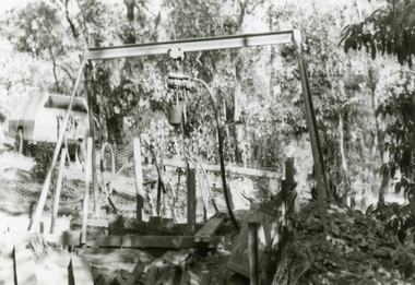
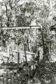
Photographs, 1979-80 MMBW pipe line project at Hubbard Reserve, North Ringwood � Swivel crane over first hole west of boring pit in 39 Burlock Avenue
Part of a 43-photo record of the MMBW�s engineering feat in drilling a 12 inch pipe line up to 40 feet deep through rock hardened by volcanic action associated with geological fault that occurs along the line. The work took place from October 1979 to May 1980 on the southern boundary of Hubbard Reserve, North Ringwood. The collection was presented to the Ringwood Historical Research Group by J Clarke on 9th June 1980.E561 N3 Feb 1980 A43 Swivel crane over first hole west of boring pit in 39 Burlock Avenue. The track used to reach Burlock Avenue on left. -
 Ringwood and District Historical Society
Photographs, 1979-80 MMBW pipe line project at Hubbard Reserve, North Ringwood � View along MMBW work line in east end of Hibberd's, showing grating over mole boring pit
Part of a 43-photo record of the MMBW�s engineering feat in drilling a 12 inch pipe line up to 40 feet deep through rock hardened by volcanic action associated with geological fault that occurs along the line. The work took place from October 1979 to May 1980 on the southern boundary of Hubbard Reserve, North Ringwood. The collection was presented to the Ringwood Historical Research Group by J Clarke on 9th June 1980.E560 N29 Feb 1980 A43 View along MMBW work line in east end of Hibberd's, showing grating over mole boring pit -
 Ringwood and District Historical Society
Photographs, 1979-80 MMBW pipe line project at Hubbard Reserve, North Ringwood � First hole in Lot 8
Part of a 43-photo record of the MMBW�s engineering feat in drilling a 12 inch pipe line up to 40 feet deep through rock hardened by volcanic action associated with geological fault that occurs along the line. The work took place from October 1979 to May 1980 on the southern boundary of Hubbard Reserve, North Ringwood. The collection was presented to the Ringwood Historical Research Group by J Clarke on 9th June 1980.E561 N2 Feb 1980 A43 Final hole in lot 8 (no. 41) at the corner of Chalkly's -
 Ringwood and District Historical Society
Photographs, 1979-80 MMBW pipe line project at Hubbard Reserve, North Ringwood � Boring hole in lot 7
Part of a 43-photo record of the MMBW�s engineering feat in drilling a 12 inch pipe line up to 40 feet deep through rock hardened by volcanic action associated with geological fault that occurs along the line. The work took place from October 1979 to May 1980 on the southern boundary of Hubbard Reserve, North Ringwood. The collection was presented to the Ringwood Historical Research Group by J Clarke on 9th June 1980.E561 N4 Feb 1980 A43 The boring hole, 39' deep, at lot 7 (Clarke's, 39 Burlock Ave) with the generator used to supply light. -
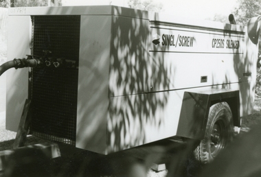 Ringwood and District Historical Society
Photographs, 1979-80 MMBW pipe line project at Hubbard Reserve, North Ringwood � compressor
Part of a 43-photo record of the MMBW�s engineering feat in drilling a 12 inch pipe line up to 40 feet deep through rock hardened by volcanic action associated with geological fault that occurs along the line. The work took place from October 1979 to May 1980 on the southern boundary of Hubbard Reserve, North Ringwood. The collection was presented to the Ringwood Historical Research Group by J Clarke on 9th June 1980.E561 N6 Feb 1980 A43 Compressor of the tunnelling gang on the sewer line in Burlock Ave