Showing 11902 items
matching geo-map
-
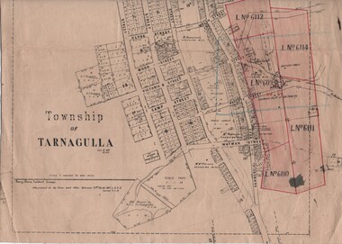 Tarnagulla History Archive
Linen-Backed Map of Tarnagulla Dated 1860 with Updates, Including Mining Leases
This is a very nice linen-backed map first published in 1860 and progressively updated, the latest being 1924 at the time of Government boring on the Poverty Reef. The map clarifies details of the mining leases as they stood in 1924, and the map also identifies previously uncertain details such as the location of the battery well, and also the location of the 1909 syndicate to the south of the Sandy Creek Co's shaft. The lightly pencilled location of the Birthday shaft is incorrect. This mine was located further to the east. -
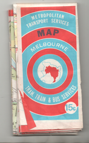 Melbourne Tram Museum
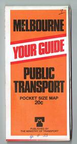
Map, Ministry of Transport, "Melbourne Transport Services Map - Tram, Train and Bus Services", c1974
Fold out map (27 sections 9 across x 3 deep), coloured of Melbourne's Tram and Bus routes, route numbers, rail lines, detailed for the central part of Melbourne and insert section for Frankston. On rear description of routes, private bus routes and map of Melbourne metro lines. Has contact details for bookings and lost property etc. Priced 15c Inscription dates the map as 1974. Two copies held.On front cover in ink "#3" in top right hand corner and "4 G 33 1974" along bottom edge of the first copy.trams, tramways, melbourne, map, tram & bus services, railways, mmtb, minister for transport -
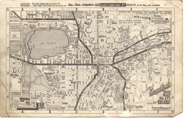 Ballarat Tramway Museum
Map, Broadbent's, "Broadbent's Official Map 177 Ballarat", c1960
Printed street map titled "Broadbent's Official Map 177 Ballarat" on a medium weight (200gsm?) card. Shows the suburbs of Ballarat, but not Sebastopol, rail lines and tram routes, schools, some churches, hospitals, parks and some features. Does not show the full length of the Lydiard St or Sebastopol tram lines. Has scale, national route numbers and distance from Ballarat PO marked on the map. In bottom left hand corner, has Broadbent's north point logo and notes that it is the 66th year of publication of road maps. Gives telephone number as MB 2021 in top right hand corner.Initials "GY" in pencil and red ink in top right hand corner.trams, tramways, map, ballarat, broadbent's, railways -
 Whitehorse Historical Society Inc.
Document - Correspondence, Letter and Map Schwerkolt houses, 9/11/1993
Letter to W. Gray, Nunawading Historical Society from Glyn France enclosing map of Schwerkolt property and rough plan of old stone house drawn by Arthur Schwerkolt [map filed at A-SP 120]. Gives information about dates of building 'old' and 'new' houses.schwerkolt, arthur, schwerkolt, myra, france glyn, schwerkolt cottage -
 Whitehorse Historical Society Inc.
Map, WW1 map of France, 08/10/1918
Enemy Rear Organisation map Scale 1 : 40,000non-fictionEnemy Rear Organisation map Scale 1 : 40,000maps, world war 1914 - 1918 -
 Bendigo Military Museum
Administrative record - International Map of the World (IMW) 1:1 Million Scale - H Ureta, Circa 1964, MR H Ereta, Post 1964
This document records the history of the International Map of the World (IMW) at 1:1Million Scale. Mr H. Ereta, Chief of the Cartographic Section of the United Nations Department of Economic Development and Social Affairs gave a lecture on the IMW and described the history and development of the map series in post 1964. This document is a copy of that lecture. 7 x Foolscap pages of typed text, stapled and two hole punched, Paper is dis-coloured.royal australian survey corps, rasvy, fortuna, army survey regiment, army svy regt, asr, imw -
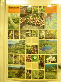 Kiewa Valley Historical Society
Map / Chart, Vegetation Map & Guide to Alpine Flora: Rocky Valley, 1982
This poster is of Rocky Valley is on the Victorian High Plains where the State Electricity Commission of Victoria worked on the Kiewa Hydro Electric Scheme and also where cattlemen brought their cattle up during summer at various times. Its significance is due to it shows the flora of the area after the Kiewa Hydro Electric Scheme Rocky Valley damn has been build and therefore is a valuable for comparison to see what plants are there now after this information on this poster was complied. Historic: Comparison of the flora at Rocky Valley with other areas on the Victorian High Plains and with Rocky Valley before and after the Kiewa Hydro Scheme and / or grazing there. Is therefore research significance and interpretive capacity due to this compatibility value.Laminated double sided vegetation map and guide to the Alpine flora of the Rocky Valley area, with photographs of plants and vegetation.rocky valley. alpine. flora. vegetation. plants. s.e.c.v.. cattlemen. victorian high plains. -
 Ringwood and District Historical Society
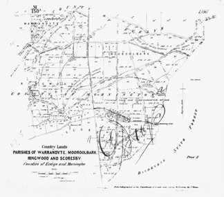
Photograph, Map-Parishes of Warrandyte, Mooroolbark, Ringwood and Scoresby. 1870
Photograph of map "Country Lands - Parishes of Warrandyte, Mooroolbark, Ringwood and Scoresby - Counties of Evelyn and Mornington" dated 1870. -
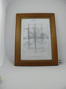
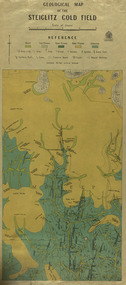 Federation University Historical Collection
Map, Geological Map of The Stieglitz Gold Field, 1940
At the bottom of the 2nd page, there is text that reads "Geologically and topographically surveyed in 1909 by W.H. Ferguson, Assistant Field Geologist. Published 1940."Rectangular geological map edged in masking tape showing Steiglitz, Victoria. Scale 48 chains to 4 inches.steiglitz, geology, geological map, north albion, moreep, mining, mine, caribald reef, durdidwarrah, gilbraltar hill, mount pleasant gully, township of steiglitz, w.h. ferguson, garibaldi reef, yankee gully, kinglock mine engine shaft, herbert werner frederick de nully, albion gully, virago reef, mulrooney's reef -
 Echuca Historical Society
Map, Map of Township - Echuca
Map on white paper that has yellowed. Black print Handwriting is black but faded. In wooden frame behind glass. Printed Survyor's plan for Echuca Township, date 5th March 1855, from the Surveyor General Office. Melbourne March 5th 1855 Plan drawn by P Chauncey. Hand written- This plan is now a Port for the South Australian Steamer Trade - when Hopwood settled here/ it was only a wild bush - he is now throwing a bridge/ at his own cost across this river 200yards wide. signed by Henry Hopwood. Typed on backing paper: Plan of the township of ECHUCA dated March 1855, One month before the first land sales / Autographed by Henry Hopwood in Oct 1955. -
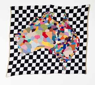 Wangaratta Art Gallery
Textile, Paul Yore, Map, 2012
I see my work with textiles as always a negotiation of both the poetic and the political. A medium often relegated to the realm of ‘craft’, I see working with wool as a subtly subversive methodology, and an opportunity to engage in socio-political critique. As a laborious yet cathartic craft, the delicately feminine familiarity and domestic warmth of my hand-sewn tapestries allows me to open up and question traditional notions of masculinity through the enactment of a highly personalized queer ritual. Furthermore, wool carries with it frontier pastoral associations of early colonial expansion, and it is in this context that the work Map, which is based on the ethnographic mapping of indigenous language groups, was envisioned.contemporaryWangaratta Art Gallery Collection. Work acquired as winner of 2013 Wangaratta Contemporary Textile Award. Digital reproduction courtesy of the artist, Neo Parc Melbourne and Hugo Michell Gallery Adelaide.A rectangular wool needlepoint textile work that features a multi-coloured map of Australia on a black and white checkered background. textile, wcta, wangaratta art gallery, paul yore, wool needlepoint -
Whitehorse Historical Society Inc.
Map, Map of Vermont area, c1895
Photocopy of part of a larger map showing the Vermont area.Photocopy of part of a larger map showing the Vermont area. Note on side 'after 1892'. Shows land holders.Photocopy of part of a larger map showing the Vermont area.maps, vermont -
Whitehorse Historical Society Inc.
Map, Map of Mitcham, Tunstall and Blackburn, c1937
Map of Mitcham, Tunststall and Blackburn showing the location of T.M. McDonnell, real estate agent, Whitehorse Road, MitchamMap of Mitcham, Tunststall and Blackburn showing the location of T.M. McDonnell, real estate agent, Whitehorse Road, MitchamMap of Mitcham, Tunststall and Blackburn showing the location of T.M. McDonnell, real estate agent, Whitehorse Road, Mitchammaps, mcdonnell, t.m. -
Whitehorse Historical Society Inc.
Map, City of Nunawading Street and Block Map
City of Nunawading Street and Block map.City of Nunawading Street and Block map. Scale: 1:10,000. with enlargement, Canterbury Road South to Burwood Highway.City of Nunawading Street and Block map. canterbury road nunawading, burwood highway burwood east, city of nunawading -
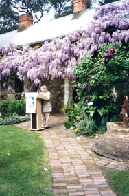 Whitehorse Historical Society Inc.
Photograph, Launch of Valley of the Arts Tourist Map, 1/10/2000 12:00:00 AM
Coloured Photo of President of the Valley of the Arts Committee speaking at the launch of the Valley of the Arts Tourists Map at Schwerkolt Cottage.valley of the arts, schwerkolt -
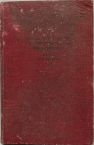 Ringwood RSL Sub-Branch
Book, Manual of Map Reading, 1955
Hard cover book with fold out maps with 132 printed pages text. Author - The War Office 1955Airphoto reading, Field sketching. -
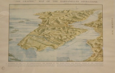 Lara RSL Sub Branch
Topagraphical Map of the Dardanelles Operations, Graphic Map of The Dardanelles Operations
WW1, Dardanelles operational map of area of Operations. Military, Naval of the "battering of the Gates of Constantinople"WW! ANZAC, British Military and Naval Operations in the Dardanelles. "battering of the Gates of Constantinople"Graphical representation of the Dardanelle's Operations displaying the Australia & New Zealand and the British operational areas and Landings. Military and Naval involvements in battering the gates to Constantinople.Small circular stamp on front left bottom - "State Library of N.S.W." and on he right hand border " Z M2 390 8/1915/3"ww!, military, naval, battering of the gates of constantinople, australia and new zealand (anzac) -
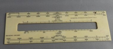 Greensborough Historical Society
Ruler, Scale rule for map reading, 1950c
Small rule to measure distance when reading a scale map. Measurements in yards or meters.Small plastic rule, cream colour with black markings.map reading, scale ruler -
National Wool Museum
Map, Northern Territory of Australia - Pastoral map
Pastoral map of the Northern Territory, 1955. Includes pastoral leases, stations, aboriginal settlements,pastoral industry - history sheep stations - history, northern territory of australia, pastoral industry - history, sheep stations - history -
Federation University Historical Collection
Map - Framed image, Public Record Office Victoria, Eureka Treason Trial Map (printed copy), 1855
The persecution produced the original of this map as an exhibit for the Treason Trials of thirteen of the Eureka Stockade in Melbourne in 1855. Witnesses at the time accepted that the map showed the location of the stockade at Ballarat and the route taken by the military and police when the stockade was attacked on 03 December 1854. The original of this work is held by the Public Record Office Victoria.Printed copy of the plan used at the Eureka Treason Trials in 1855.eureka stockade, treason trial map, ballarat, lydiard street north, camp street, paroompi, yarrowee creek -
 Bacchus Marsh & District Historical Society
Map, Maddingley Township, Parish of Parwan, 1880s
This map is dated Sept. 6th 1856. However places in the township of Maddingley which did not appear until the late 1880s such as the Bacchus Marsh Railway Station and line are shown on this map in their correct locations. This suggests the map has been derived from an earlier map. An earlier date of 1843 with a surveyor's name preceding it can also be seen on the map. The map is important because it indicates the location and dimensions of early but now discontinued use of land such as the showgrounds and police paddock and a site reserved for the Church of England which was not ultimately used for a permanent church. A single page paper map showing land allotments, streets, rivers, creeks, park lands, the railway line and Bacchus Marsh railway station in the township of Maddingley. The map is pasted into a bound volume containing 76 maps or plans in total. Bottom of Map: Surveyor-General's Office, Melbourne, Sept 6th, 1856bacchus marsh victoria maps, maddingley victoria maps, land use, maddingley victoria history -
Whitehorse Historical Society Inc.
Map, Melbourne Metropolitan Area Base Map series. Sheet 214, c1960
Map showing northern section of the City of Nunawading together with parts of Shire of Doncaster and Templestowe.Map showing northern section of the City of Nunawading together with parts of Shire of Doncaster and Templestowe. Shows roads, creeks, block numbers and contours at 5 feet vertical increments. Note on map: 'prepared ... from State Aerial Survey, January 1957 and Cadastral Survey information February 1959'.Map showing northern section of the City of Nunawading together with parts of Shire of Doncaster and Templestowe. maps, city of nunawading, shire of doncaster and templestowe -
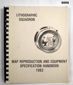 Bendigo Military Museum
Manual - Map Reproduction and Equipment Specification Handbook, 1982
This handbook provided comprehensive technical information principally to the lithographic technician and to other Royal Australian Survey Corps technical trades. Part 1 comprised technical descriptions and photos of lithographic equipment used in military map production. Part 2 provided various tables such as printing sizes conversion tables. Part 3 provided technical guidance on the stipples and screens utilised in the map reproduction process. Part 4 detailed the Pantone Matching System printing colours for map and chart products. Part 5 was a Glossary of Lithographic Technical Terms.Army Survey Regiment Manual/handbook with a manilla cover comprising approximately 100 pages. The pages in the document are in black and white paper providing technical information and photograph identifying lithographic equipment and other information to lithographic technicians. Printed on standard paper bound by a by a black plastic spiral spline.royal australian survey corps, rasvy, fortuna, army svy regt, asr, army survey regiment -
 Melbourne Tram Museum
Map, Ministry of Transport, "Metropolitan Transport Services Map - Melbourne Tram, Train and Bus Services", 10/1971
Fold out map (27 sections 9 across x 3 deep), coloured of Melbourne's Tram and Bus routes, route numbers, rail lines, detailed for the central part of Melbourne. On rear description of routes, private bus routes and map of Melbourne metro lines. Has contact details for bookings and lost property etc. Priced at 10c. Launched in a newspaper advert 26/10/1971. Has map scale in miles. 2nd copy added 16/7/2014On front cover in ink "#1" in top right hand corner and "4 G 33" along bottom edge.trams, tramways, melbourne, map, tram & bus services, railways, mmtb, minister for transport -
 Melbourne Tram Museum
Map, Ministry of Transport, "Melbourne Transport Services Map - Tram, Train and Bus Services", 1977
Fold out map (27 sections 9 across x 3 deep), coloured of Melbourne's Tram and Bus routes, route numbers, rail lines, detailed for the central part of Melbourne and insert section for Frankston. On rear description of routes, private bus routes and map of Melbourne metro lines. Map No. 7, 1977. Has contact details for bookings and lost property etc. Priced 20c. 1977, route 59 showing as terminating opposite Essendon Airport.On front cover in ink "" in top right hand corner and "4 G 33 " along bottom edge.trams, tramways, melbourne, map, tram & bus services, railways, mmtb, minister for transport -
Tatura Irrigation & Wartime Camps Museum
Document, Map of encounter
Map of encounter between HMAS "Sydney" and HSK "Kormoran" copied from Captain Detmer's book. -
 Stawell Historical Society Inc
Photograph, Mr Sydney Davidson as a Soldier in WW1 in uniform with rifle, webbing, & map case 1914-1918 -- Studio Portrait
Portrait Sydney Davidson 1914-18 Soldier WW1 in uniform with rifle webbing and map casestawell war -
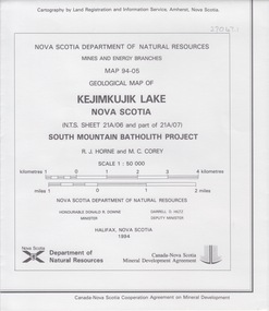 Federation University Historical Collection
Map - Geological, Nova Scotia Department of Natural Resources, Kejimkujik Lake, Nova Scotia: Geological Map 94-05, 1994
Produced b Nova Scotia Department of Natural Resources, Mines and Energy Branches. The Minister of the Department was the Honourable Donald R Downe and the Deputy Minister was Darrell D HiltzLarge coloured map depicting different areas and deposits. Includes a legend, symbols used, mineral abbreviations and alteration abbreviations.Symbolsnova scotia, kejimkujik lake, geological survey, cartography, mine and energy branches, donald r downe, minister, darrell d hiltz, deputy mnister, south mountain batholith project, legend, symbols -
Federation University Historical Collection
Map - Map - Geological, Kejimkujik Lake, Nova Scotia: Geological Map 94-05, 1994
Produced by Nova Scotia Department of Natural Resources, Mines and Energy Branches. The Minister of the Department was the Honourable Donald R Downe and the Deputy Minister was Darrell D HiltzLarge coloured map depicting different areas and deposits. Includes a legend, symbols used, mineral abbreviations and alteration abbreviations.Symbolskejimkujik lake, nova scotia -
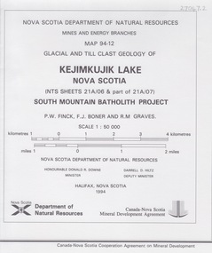 Federation University Historical Collection
Map - Geological, Kejimkujik Lake, Nova Scotia: Glacial and Till Clast Geology: Map 94-12, 1994
Produced b Nova Scotia Department of Natural Resources, Mines and Energy Branches. The Minister of the Department was the Honourable Donald R Downe and the Deputy Minister was Darrell D HiltzLarge coloured map depicting different areas and deposits. Includes a legend, symbols used, mineral abbreviations and alteration abbreviations.Symbols