Showing 1088 items matching "geology"
-
 Bendigo Historical Society Inc.
Map - STRUGNELL COLLECTION: HUSTLER'S LINE OF REEFS, September 1913
Map, Hustler's Line of Reefs, Hustler's Reef & Hustler's Reef No.1 Mines Plan.Plate No. XV1.(16) Sheet 2 .Bulletin No 33 Signed H.A.Whitelaw.Underground Survey Office, Bendigo, September,1913. Included is the emblem of the Geological Survey of Victoria. Drawing shows a plan view of reefs and shaft locations .Underground Survey Office, Bendigomap, bendigo, hustler's reef & hustler's reef 1 -
 Whitehorse Historical Society Inc.
Map, Melbourne Geological Map, 1937
Geological Map of Melbourne & Suburbs.Geological Map of Melbourne & Suburbs. Scale: 40 chains to 1 inch with inset 10 miles to 1 inch. Includes Municipal and Parish boundaries, railways and stations, electric tramways, cable tramways, Post Offices and State schools. Area bounded by Braybrook, Preston, Blackburn & Brighton. Printed on linen.Geological Map of Melbourne & Suburbs. melbourne, maps -
 Bendigo Historical Society Inc.
Document - PETER ELLIS COLLECTION: NOTES MENTIONING WHIPSTICK REGION
Four pages of typed notes mentioning the Whipstick Region, Mandurang Forest, Jackass Flat, Diamond Hill Area, One Tree Hill, and the Coliban/Sandhurst Water Supply Reserve. Mentioned are the Birds, Mammals, Geology, Flora, Ground Flora, Orchids,Lilies, Mistletoe, Ferns and Grasses of some of the areas.bendigo, parks and gardens, public reserves, peter ellis collection, north/central l.c.c. region bendigo block, bendigo field naturalists club, shipstick scrub, mandurang forest, one tree hill public park, redvers j eddy, coliban/sandhurst water supply reserve -
 Bendigo Historical Society Inc.
Document - MINING REPORTS - DEBORAH MINE - QUARRY HILL
Handwritten notes from a report by J. J. Caldwell, District Geologist. Ref. M. & Geological, July 1938. Page 29. Depth of Shaft 30 - 9 - 1937 - including well was 1025 feet as at 3 - 10 - 1932. Water was then making 500 gallons per hour. Baled with tanks.document, gold, mining reports, deborah mine quarry hill, m & geological, j j caldwell -
 Bendigo Historical Society Inc.
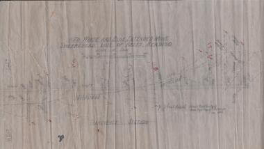
Map - UNITED HUSTLER'S & REDAN MINE - TRANSVERSE SECTIONS N & S OF SHAFT UNITED HUSTLER'S & REDAN MINE
Transverse Sections N & S of Shaft United Hustler's & Redan Mine on the Hustler's Line of Reef Bulletin No 33, Plate No XXX. Map shows some of the stone encountered on the levels and depth. Geological Survey of Victoria emblem and signed by H A Whitdan, Underground Survey Office Bendigo, September 1913.mining, parish map, united hustler's & redan mine, transverse sections n & s of shaft united hustler's & redan mine, hustler's line of reef -
 Federation University Historical Collection
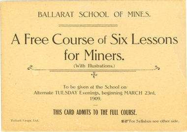
Card, Tulloch Proprietary Limited, Ballarat School of Mines, Advertisement Card, 1909, 1909
The Ballarat School of Mines was the first school of mines in Australia. It offered courses of study as well as introductory or public lectures. Brown ticket with black printing on both sides. The ticket is for a free course of six evening lessons for miners at the Ballarat School of Mines. Verso gives the topics and lecturer for each of the 6 weeks. 23 March 1909 - Introduction "Properties of Gold made use of in its Metallurgy A. Mica Smith. 6 April 1909 - "Geological Aids to Mining" - T. S. Hart. 20 April 1909 - "Mine Surveying" - A.D. Gilchrist. 4 May 1909 - "The application of Chemistry to Mining" - D. Walker. 18 May 1909 - "Some Application of electricity ot Mining" J.M. Sutherland. 01 June 1909 - "Some Physical Properties of the Atmosphere affecting Mines" B. Whitington.ballarat school of mines, mining, lectures, classes, gold, metallurgy, geology, surveying, electricty, mica smith, alfred mica smith, hart, thomas hart, gilchrist, walker, daniel walker, sutherland, john m. sutherland, john sutherland, whitington -
Ringwood and District Historical Society
Piece of Rock, Collected by J. Lundy-Clarke, Lump of Black Rock - Sample of Metamorphic Rock from Hubbard Park, Ringwood 1979, Found 1979
Sample of metamorphic rock encountered by M.M.B.W. gang of tunnellers boring for a sewer drain through a geological fault-dyke along the southern boundary of Hubbard Park. The hole for 900 feet of 12.5 inch pipe took 6 months to bore from Oct-1979 to May-1980.Lump of black rock. +Additional Keywords: Lundy-Clarke, J. -
 Warrnambool and District Historical Society Inc.
Booklet - Booklet: Settlement of the Western District, Collett, Bain and Gaspar, Printers, Settlement of the Western District From Prehistoric Times to the Present, 1985
This booklet documents a public lecture series held in Warrnambool 3rd November 1984.This is a soft-cover book of 133 pages on the settlement of the Western District from prehistoric times to the present. It has a blue paper front cover and a grey paper back cover. The front cover is covered with a clear plastic sheet and the binding is plastic. The cover has an image of a sketch of the Warrnambool beach showing the lighthouse complex on Middle Island and the lighthouse on the beach (established 1860). There are a Contents page, a Foreword, a List of Plates and seven articles on different aspects of the Western District history by different authors. There are black and white photographs and illustrations. One page (p.17) has been annotated by Les O’Callaghan.This booklet documents a public lecture series held in Warrnambool 3rd November 1984.western victorian history, edmund gill, peter ronald, john sherwood, jan critchett, tony dingle, miles lewis, kevin o’toole, warrnambool, history -
Federation University Historical Collection
Booklet, Ballarat School of Mines Student's Magazine, September 1899, 1899
Table of contents: Editorial, News and Notes, Summaries and notes from the mining journals, Some recent steam plants at Bendigo, Professor T. S. hart. Students' Association, Notes on Victorian geology, Centrifugal pumps, A new chum's experience, Original poetry, Correspondence, Editorial notices.Pale green booklet of 12 pagesballarat school of mines, students' magazine, w. huey steele, w. lamb, j. m. bickett, james bickett, alex frazer, j. w. sutherland, a. w. g. mcpherson, w. a. gosman, w. waite, a. selwyn brown, a. babington, c. w. mirill, ottokar hofmann, professor g. j. dawbarn, professor t. s. hart, thomas hart, a. e. c. kerr -
Federation University Historical Collection
Book - Exercise book, The Metallurgy of Gold and Ore Dressing, 1908
William Baragwanath studied at the Ballarat School of Mines, obtained a Geology certificate in 1911. He was born on 01 august 1878 at Ballarat. He joined the Victorian Department of Mines in 1897 and was Chief Mining Surveyor from 1924 to 1943. Baragwanath died at Prahran on 20 Septemeber 1966.Black covered exercise book containing handwritten notes by William Baragwanath on metallurgy of gold & orr dressing Headings include: Orr dressing Battery practice Physical properties Copper Gold Assaying ballarat school of mines, mining, william baragwanath, gold, copper -
Federation University Historical Collection
Exercise Book, William Baragwanath, William Baragwanath's Exercise Book, 1898, 1898
William Baragwanath studied at the Ballarat School of Mines, obtained a Geology certificate in 1911. He was born on 01 August 1878 at Ballarat. He joined the Victorian Department of Mines in 1897 and was Chief Mining Surveyor from 1924 to 1943. Baragwanath died at Prahran on 20 Septemeber 1966.Marbled blue card covered exercise book with yellow tape spine containing handwritten notes by William Baragwanath on dividing land problems, earthworks, refraction, etc; Headings include: Tom Joe Smith ballarat school of mines, earthworks, land problems, refraction, william baragwanath, -
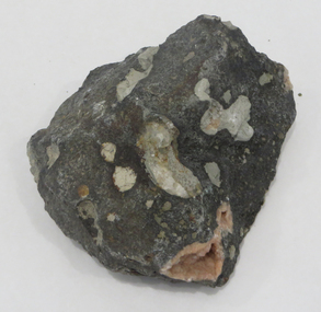
 The Beechworth Burke Museum
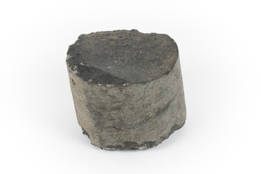
Geological specimen - Basalt
This specimen was recovered from Creswick in Victoria. Basalt is dark in colour, often black and has a fine grain. It is composed of plagioclase and pyroxene minerals and an igneous rock. This specimen is part of a larger collection of geological and mineral specimens collected from around Australia (and some parts of the world) and donated to the Burke Museum between 1868-1880. A large percentage of these specimens were collected in Victoria as part of the Geological Survey of Victoria that begun in 1852 (in response to the Gold Rush) to study and map the geology of Victoria. Collecting geological specimens was an important part of mapping and understanding the scientific makeup of the earth. Many of these specimens were sent to research and collecting organisations across Australia, including the Burke Museum, to educate and encourage further study.A cylindrical fine-grained piece of igneous rockburke museum, geological survey of victoria, geological specimen, geology -
 Federation University Historical Collection
Rocks, A variety of slabs, such as Jasper, thunder egg, etc
From the Ballarat School of Mines.A number of rock slabs, some cut and polished. .1) Thunder egg .2) Jasper? .3) rocks, thunder egg, jasper, geology -
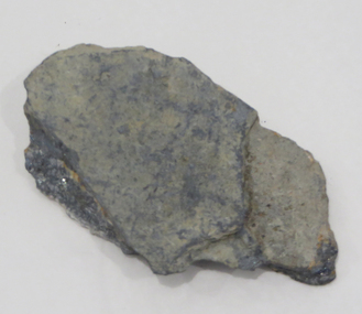 Federation University Historical Collection
Rocks, Stibnite, Casterfield
From the Ballarat School of Mines.rocks, thunder egg, jasper, geology -
 Federation University Historical Collection
Rocks, Gemolite, Flinders
From the Ballarat School of Mines.Gemolite, Flindersgeology, rock, gemolite, flinders -
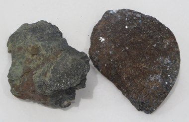 Federation University Historical Collection
Rocks, Galena with Rodinite and Bustamite
From the Ballarat School of Mines.Gemolite, Flindersgeology, rock, gemolite, flinders -
 Federation University Historical Collection
Geological specimen - Rocks, Copper Specimen, Broken Hill, New South Wales
From the Ballarat School of Mines.Copper Specimen, Broken Hill, New South Walesrocks, geology, copper, broken hill -
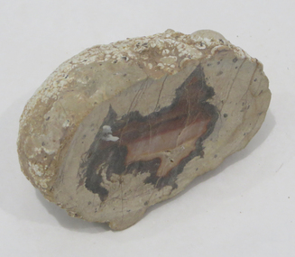
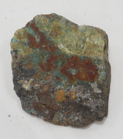
Federation University Historical Collection
Geological specimen
geology, rocks, sap hill cemment, golden point ballarat cement -
Glenelg Shire Council Cultural Collection
Photograph - Photograph - Princess Margaret Rose Caves, n.d
Coloured photograph of stalagmites and stalactites beside pathway in Princess Margaret Rose caves.travel, princess margaret rose caves, tourism, geology -
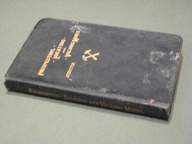 Federation University Historical Collection
Book, Prospecting, Locating and Valuing Mines, 1902
This book was most probably used at the Ballarat School of Mines.Black covered book with gold title. 381 pages. The book was 'a popular treatise for the use of prospectors, investors and Mining Men generally; with an account of the Principal Minerals and Country rocks; Ore Deposits; Locations and Patents; the early Development of Mines; Earthy Mineral Products; Coal; Gold gravels and gravel Mining; Measurement of Water; and Artesian Wells'.mining, ballarat school of mines, water, geology -
Federation University Historical Collection
Book, A Textbook if Ore and Stone Mining, 1901
Red hard covered book 12ore, mining, stone, geology -
Federation University Historical Collection
Document, Robert S. Brain, Report on Rapid Surveys of the Gold-fields, Report on Parish of Mannibadar
One printed page.mannibadar, ernest lidget, geology, j. travis -
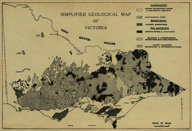 Ballarat Heritage Services
Map, Simplified Geological Map of Victoria, c1940, c1940
Physiographic map of Victoriavictoria, map, geology, geological -
 Ballarat Heritage Services
Photograph - Image - Black and White, Golden Point, Ballarat
Black and white image showing the site of the earlies discovery of first rate mining importance to Australia. The gold occurs in gravel lying on Lower Palaeozoic slatesgolden point, ballarat, gold, geology, gold discovery -
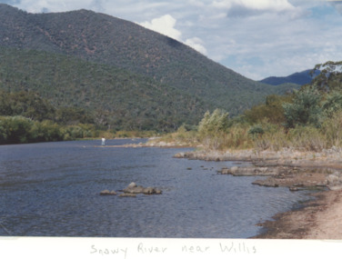 Lakes Entrance Historical Society
Photograph - Snowy River near Willis Victoria, M Holding, 1994 c
Colour photograph of the Snowy River in the alpine Country near Willis Victoriageology, topography, rivers, mountains -
 Federation University Historical Collection
Book, Hydraulic and Placer Mining, 1898, 1905
Blue/black hard covered book of 234 pages including index and photographic reproductions. Contents include Uses of Water in Mining; Geology of Placer Deposits; Gold Recovery; Flumes, ditches, dams, pipes; Giants, valaves, gates, weirs, miner's inch, pressure box, dams; gravel elvators; exploiting. mining, hydraulics, water, dredge, dredging, gold mining -
 Bendigo Historical Society Inc.
Map - RED WHITE & BLUE EXTENDED - PLAN OF RED WHITE AND BLUE EXTENDED MINE TRANSVERSE SECTION
Transverse section of the Red White & Blue Extended Mine on the Sheepshead Line of Reef showing shafts, depths and geological features. Drawn on tracing film in pencil. Signed by J J Caldwell, District Field Geologist, Mines Department, Bendigo and dated 5/12/1940. Notes prepared by Albert Richardson.document, gold, red white & blue extended, red white & blue extended, plan of red white & blue extended mine transverse section, j j caldwell, mines dept bendigo -
 Kiewa Valley Historical Society
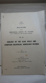
Document - Four Geological reports on the North-east Goldfields, Geological Survey of Victoria 1958 Bulletin
Geological Surveys of N.E. Goldfields Victoria included mines and tunnels. A resurvey of goldfields was necessary to re-assess economic possibilities using modern techniques and structural interpretation. It included an examination of a considerable surface area with maps and underground workings. Results were correlated and integrated and published by the Mines Department.The mines are in the Bogong Alpine Area.Foolscap printed Victorian Bulletins. Each stapled in the top left corner and each with varying number of pages. Covering 1941-1958 a) Glen Wills and Sunnyside b) Sunnyside Tunnel c) Red Robin d) Maud and Yellow Girl Government Printer, Mines Department, Melbourne, Victoriageology in the north-east, gold fields, goldmines, glen wills -
Federation University Historical Collection
Booklet, Ballarat School of Mines Student's Magazine, March 1899, 1899
Table of contents: Editorial, News and Notes, History of the School of Mines, Notes on Victorian Geology, Sir William Crookes, Summaries and notes from the mining journals, Students' Association, Sports, The Bush Assayer, Solubility of gold-silver alloys in potassium cyanide, Correspondence, Editorial notices, Publication receivedPale green booklet of 12 pagest. s. hart, sir william crookes, c. woodman, henry watson, james stirling, c. a. mulholland, s. b. j. skertchly, george f. becker, arthur h. thorpe, arthur s. boucher, henry louis, alfred james, john plummer, louis coste, w. terrill, h. g. brickhill, f. j. andrews, adam morton, w. gosman, j. matson, h. schaw, j. h. pratt, henry watson, william mcneil, ballarat school of mines, students' magazine -
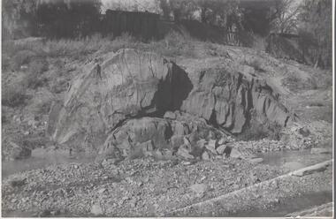 Bendigo Historical Society Inc.
Photograph - Napoleon Anticline, 1935
In structural geology, an anticline is a type of fold that is an arch-like shape and has its oldest beds at its core, whereas a syncline is the inverse of an anticline. A typical anticline is convex up in which the hinge or crest is the location where the curvature is greatest, and the limbs are the sides of the fold that dip away from the hinge.Significant to mining history of Bendigo.Black and white photograph: rock formation, anticline with an archlike shape in centre of image. Written in pencil on back of photograph : 'Napoleon anticline Golden Square'.napoleon gold mine, anticline