Showing 615 items
matching gold field
-
 Eltham District Historical Society Inc
Photograph, Kangaroo Ground War Memorial, Eltham Heritage Tour, 24 May 1992, 24/05/1992
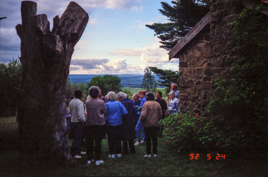
ELTHAM HERITAGE TOUR The Society excursion on 24th May 1992 was arranged by David Bick, leader of the team carrying out the Shire's heritage study. David selected a number of sites or buildings identified in the study, some of them lesser known components of the Shire's heritage. The tour commenced at the Eltham Shire Office at 10.00 am. Travel was by private car and mini-bus with stops at about twelve locations for commentary by David.It included a short walk in Hurstbridge and lunch at Kinglake. Highlights of the tour included: - 10 am Leave from Shire Offices - 3 Important Trees - A Physical Link to Eltham's First Settlers - Toorak Mansion Gates - A Surviving Farm House - An Intact Circa 1900 Main Street - First Settlers - Gold Miners, and Timber-getters - An Early Hotel - A Pioneering Homestead - Changing Eltham Shire - 20th Century - 4 pm Afternoon Tea and Finish Tour Extract from ELTHAM CULTURAL HERITAGE TOUR (Newsletter No. 85, July 1992, by Bettina Woodburn) "Now we drove through stands of pines to the Kangaroo Ground Lookout Tower, a most unusual War Memorial, World War I. The tower and a shed/residence (it had a chimney) were built from local sandstone. Below to the south and east of Melbourne spread 'suburbia'. Close by the landscape seemed so contrived - English fields and hedgerows! Although only about twenty inches deep, the soil of this ancient volcano, its crater lost under subsequent weathering, was rich, deserving the name of "Garden Hill". Now native trees are taking over again. In Kangaroo Ground itself stand the inevitable Store, School and Church - and two Norfolk pines and a monkey puzzle tree."Record of the Society's history and activities and highlighting various aspects of the Heritage Study undertaken by David Bick used to create the future heritage overlay for the Shire of Eltham and later Nillumbik Shire.Roll of 35mm colour negative film, 4 stripsKodak Gold 100 5095shire of eltham historical society, activities, heritage tour, kangaroo ground, kangaroo ground tower, war memorials, kangaroo ground memorial -
 Eltham District Historical Society Inc
Photograph, Shire of Eltham War Memorial, Memorial Park, Garden Hill, Kangaroo Ground; Eltham Heritage Tour, 24 May 1992, 24/05/1992
ELTHAM HERITAGE TOUR The Society excursion on 24th May 1992 was arranged by David Bick, leader of the team carrying out the Shire's heritage study. David selected a number of sites or buildings identified in the study, some of them lesser known components of the Shire's heritage. The tour commenced at the Eltham Shire Office at 10.00 am. Travel was by private car and mini-bus with stops at about twelve locations for commentary by David.It included a short walk in Hurstbridge and lunch at Kinglake. Highlights of the tour included: - 10 am Leave from Shire Offices - 3 Important Trees - A Physical Link to Eltham's First Settlers - Toorak Mansion Gates - A Surviving Farm House - An Intact Circa 1900 Main Street - First Settlers - Gold Miners, and Timber-getters - An Early Hotel - A Pioneering Homestead - Changing Eltham Shire - 20th Century - 4 pm Afternoon Tea and Finish Tour Extract from ELTHAM CULTURAL HERITAGE TOUR (Newsletter No. 85, July 1992, by Bettina Woodburn) "Now we drove through stands of pines to the Kangaroo Ground Lookout Tower, a most unusual War Memorial, World War I. The tower and a shed/residence (it had a chimney) were built from local sandstone. Below to the south and east of Melbourne spread 'suburbia'. Close by the landscape seemed so contrived - English fields and hedgerows! Although only about twenty inches deep, the soil of this ancient volcano, its crater lost under subsequent weathering, was rich, deserving the name of "Garden Hill". Now native trees are taking over again. In Kangaroo Ground itself stand the inevitable Store, School and Church - and two Norfolk pines and a monkey puzzle tree." On November 11th 1926 the Shire of Eltham War Memorial Tower at Kangaroo Ground was opened. It is regarded as one of Melbourne’s most outstanding lookout towers. It commands a magnificent 360 degree panorama from Kinglake across the Diamond Valley to Macedon and the You Yangs. It is built on a peak which was once a volcano, 237 metres above sea level. After World War one a memorial cairn was erected on the site, and in 1925 a committee of public-minded citizens began to plan for a tower. Many generous donations of material and money were forthcoming so that in 1926 the Governor General Lord Stonehaven was able to unveil the plaque before a crowd of 500 people. There was some concern in the 1960s when the Forests Commission wanted to build a firespotters cabin on the top. At first R.S.L. branches opposed the idea, but it was realised that this use could combine with its use as a tourist attraction, and would ensure its maintenance for the future, Today the Kangaroo Ground tower provides one of the best views around Melbourne and is a fitting memorial to those who died in two world wars. From: Historic items for Diamond Valley Community Radio September 1990 (EDHS collection) Record of the Society's history and activities and highlighting various aspects of the Heritage Study undertaken by David Bick used to create the future heritage overlay for the Shire of Eltham and later Nillumbik Shire.Roll of 35mm colour negative film, 4 stripsKodak Gold 100 5095culture, events, garden hill, kangaroo ground, kangaroo ground memorial, memorial park, shire of eltham war memorial tower, war memorials -
 Eltham District Historical Society Inc
Photograph, The Leader, The "Black Swan" Mine and "The Old Dam", Warrandyte Gold Fields, 1897
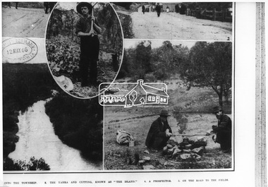
... The "Black Swan" Mine and "The Old Dam", Warrandyte Gold Fields ...Reproduced from "The Leader" 14th Aug. 1897, page 7 The "Black Swan" mine - on Captain Selby's property of 200 acres. Discovered by Captain Selby 8 years ago. He is working it himself. 'The shaft is down 70 feet and with deeper sinking the reef is found to increase in width. Nearly £2,000 has been obtained from this mine, the gold being of high quality, fetching £4-1-6 per oz.' Warrandyte photo "The Old Dam" - erected accross the river by Mr John Wallace, M.L.C., who attempted to turn the river and to work the river bed.This photo forms part of a collection of photographs gathered by the Shire of Eltham for their centenary project book,"Pioneers and Painters: 100 years of the Shire of Eltham" by Alan Marshall (1971). The collection of over 500 images is held in partnership between Eltham District Historical Society and Yarra Plenty Regional Library (Eltham Library) and is now formally known as the 'The Shire of Eltham Pioneers Photograph Collection.' It is significant in being the first community sourced collection representing the places and people of the Shire's first one hundred years.Digital imagesepp, shire of eltham pioneers photograph collection, warrandyte, gold mining, black swan mine, old dam -
 Eltham District Historical Society Inc
Photograph, The Warrandyte Gold Fields. "On the road to the Fields", c.1906 (reproduced from "The Australasian" 12th May 1906, page 1115)
... The Warrandyte Gold Fields. "On the road to the Fields", c.1906 ...Source: La Trobe LibraryThis photo forms part of a collection of photographs gathered by the Shire of Eltham for their centenary project book,"Pioneers and Painters: 100 years of the Shire of Eltham" by Alan Marshall (1971). The collection of over 500 images is held in partnership between Eltham District Historical Society and Yarra Plenty Regional Library (Eltham Library) and is now formally known as the 'The Shire of Eltham Pioneers Photograph Collection.' It is significant in being the first community sourced collection representing the places and people of the Shire's first one hundred years.Digital imagesepp, shire of eltham pioneers photograph collection, warrandyte, gold mining -
 Eltham District Historical Society Inc
Photograph, Monash Bridge, Arthurs Creek Road, Hurstbridge, Eltham Heritage Tour, 24 May 1992, 24/05/1992
ELTHAM HERITAGE TOUR The Society excursion on 24th May 1992 was arranged by David Bick, leader of the team carrying out the Shire's heritage study. David selected a number of sites or buildings identified in the study, some of them lesser known components of the Shire's heritage. The tour commenced at the Eltham Shire Office at 10.00 am. Travel was by private car and mini-bus with stops at about twelve locations for commentary by David.It included a short walk in Hurstbridge and lunch at Kinglake. Highlights of the tour included: - 10 am Leave from Shire Offices - 3 Important Trees - A Physical Link to Eltham's First Settlers - Toorak Mansion Gates - A Surviving Farm House - An Intact Circa 1900 Main Street - First Settlers - Gold Miners, and Timber-getters - An Early Hotel - A Pioneering Homestead - Changing Eltham Shire - 20th Century - 4 pm Afternoon Tea and Finish Tour Extract from ELTHAM CULTURAL HERITAGE TOUR (Newsletter No. 85, July 1992, by Bettina Woodburn) "On the Arthurs Creek Road is a bridge designed by Monash, which we admired before walking across the little park with a mud-brick and timber shelter, to the Hurst family graveyard. There are two marked graves, one, Henry who was shot by Burke the bushranger and a cairn has a plaque listing others buried here from 1866 onwards. Burke was captured and tied to the wheel of a dray under the eucalypt near the waterhose/standpipe. Close by the kindergarten, at this place are three trees on the National Trust Register, a Canary Island pine, a Canadian cedar and probably a spruce. Radiata pines and a thick bolled peppercorn surround the little cemetery. Continuing along Main Street we notice elm trees planted as a war memorial, then on the left a 1930 timber house, a 1910 store and residence, resplendent with wrought iron trim, a double fronted Hardware Store and cypresses on the back alignment of a new vacant block. On the right side of the street is a less interesting attempt at an 'in character' shop. Further on are more early homes, one tucked away at the rear with two tall palms by the front steps. Another curiosity is a rounded veranda corner and there are more galvanised iron sheds or garages, before a mud-brick Dentist's Surgery. Beyond the round-a-about is St Peters Church, of mud-brick construction shared by Catholic and Anglican parishioners, overlooking the river flood plain. Leaving Hurstbridge on the Kinglake Road, we ate our picnic lunch beside the communication tower and enjoyed views of Melbourne, Yan Yean Reservoir and the distant Dandenongs beyond the spreading suburbs. Next we drove to the North West boundary of the Shire at Masons Falls Road towards Whittlesea. On the way to the North East Boundary we passed St Peters, a yellow wooden Church with a Tudor Archway; built in the early 1920's in the style of the 1860's. From the Healesville-Kinglake road the rolling hills had European aspects, the hedged fields and chestnut trees. Then it was back down the Hurstbridge Road through 'Aussie' bush of towering gums, with bracken and scrubby understorey, the Kinglake National Park, before more open country with deciduous trees planted in line, and a creek lined with willows."Record of the Society's history and activities and highlighting various aspects of the Heritage Study undertaken by David Bick used to create the future heritage overlay for the Shire of Eltham and later Nillumbik Shire.Roll of 35mm colour negative film, 4 stripsKodak Gold 100 5095shire of eltham historical society, activities, heritage tour, hurstbridge, monash bridge, arthurs creek road -
 Eltham District Historical Society Inc
Photograph, Kangaroo Ground War Memorial, Eltham Heritage Tour, 24 May 1992, 24/05/1992
ELTHAM HERITAGE TOUR The Society excursion on 24th May 1992 was arranged by David Bick, leader of the team carrying out the Shire's heritage study. David selected a number of sites or buildings identified in the study, some of them lesser known components of the Shire's heritage. The tour commenced at the Eltham Shire Office at 10.00 am. Travel was by private car and mini-bus with stops at about twelve locations for commentary by David.It included a short walk in Hurstbridge and lunch at Kinglake. Highlights of the tour included: - 10 am Leave from Shire Offices - 3 Important Trees - A Physical Link to Eltham's First Settlers - Toorak Mansion Gates - A Surviving Farm House - An Intact Circa 1900 Main Street - First Settlers - Gold Miners, and Timber-getters - An Early Hotel - A Pioneering Homestead - Changing Eltham Shire - 20th Century - 4 pm Afternoon Tea and Finish Tour Extract from ELTHAM CULTURAL HERITAGE TOUR (Newsletter No. 85, July 1992, by Bettina Woodburn) "Now we drove through stands of pines to the Kangaroo Ground Lookout Tower, a most unusual War Memorial, World War I. The tower and a shed/residence (it had a chimney) were built from local sandstone. Below to the south and east of Melbourne spread 'suburbia'. Close by the landscape seemed so contrived - English fields and hedgerows! Although only about twenty inches deep, the soil of this ancient volcano, its crater lost under subsequent weathering, was rich, deserving the name of "Garden Hill". Now native trees are taking over again. In Kangaroo Ground itself stand the inevitable Store, School and Church - and two Norfolk pines and a monkey puzzle tree."Record of the Society's history and activities and highlighting various aspects of the Heritage Study undertaken by David Bick used to create the future heritage overlay for the Shire of Eltham and later Nillumbik Shire.Roll of 35mm colour negative film, 4 stripsKodak Gold 100 5095shire of eltham historical society, activities, heritage tour, kangaroo ground, kangaroo ground tower, war memorials, kangaroo ground memorial -
 Kiewa Valley Historical Society
Document - Four Geological reports on the North-east Goldfields, Geological Survey of Victoria 1958 Bulletin
... Alpine Area. geology in the north-east gold fields goldmines glen ...Geological Surveys of N.E. Goldfields Victoria included mines and tunnels. A resurvey of goldfields was necessary to re-assess economic possibilities using modern techniques and structural interpretation. It included an examination of a considerable surface area with maps and underground workings. Results were correlated and integrated and published by the Mines Department.The mines are in the Bogong Alpine Area.Foolscap printed Victorian Bulletins. Each stapled in the top left corner and each with varying number of pages. Covering 1941-1958 a) Glen Wills and Sunnyside b) Sunnyside Tunnel c) Red Robin d) Maud and Yellow Girl Government Printer, Mines Department, Melbourne, Victoriageology in the north-east, gold fields, goldmines, glen wills -
 Eltham District Historical Society Inc
Book, Golden Days on the Caledonian Diggings: the diaries of Thomas Young of Kangaroo Ground, Panton Hill and Christmas Hills, compiled by Mick Woiwod, 2005
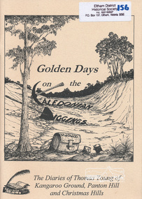
... goldfields. thomas young caledonian gold fields kangaroo ground ...The original diaries, (1859-1866,1895-1900) of Thomas Young discovered by a Young descendant have been transcribed with the author adding his own research and historical photographs. The diary sheds light on the lives of prospectors who worked the Caledonian goldfields in the 1860s, including St Andrews and Smiths Gully. Thomas Young, migrated from Scotland and moved to the goldfields in 1858. He carted ore by horse and dray from mines around St Andrews to crushers in Panton Hill and Smiths Gully. He later became a baker. He and his wife Bridget had eleven children. He later settled at Christmas Hills establishing the local store and school. See also: "Old Diary Strikes Old" by Natalie Birch, Diamond Valley Leader August 17 2005The diary provides a rare first-hand account of life on the Caledonian goldfields.v. : ill. 69 p 30 cm[written inside front cover] To my very good friend Harry Gilham - Mick Woiwod 25th August 2005thomas young, caledonian gold fields, kangaroo ground, christmas hills, panton hill, smiths gully, st andrews, diary, gold mining -
 Warrnambool and District Historical Society Inc.
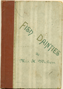
Book, Fish Dainties By Mrs H Wicken
Harriet Frances Wicken, 1847_ 1937 was a cookery lecturer and demonstrator in London and published her first book " Kingswood Cookery Book" in 1885. She migrated to Australia in 1886 and gave cookery classes at Warrnambool. Over the ensuing years she worked as a Technical Teacher in Sydney and published a number of books on cookery and domestic economy and housekeeping.The author is one of reknown in her field and spent a period of time in Warrnambool. The contents of the book show methods of cooking and typical fish dishes of the time.Small, hardcover book, cream with regency style pattern printed in grey. Spine bound in watermarked maroon. The title, "Fish Dainties by Mrs H Wicken," is written in dark green with gold capitals. Back cover is same colour but blank of any text. Written at the request of the Mutual Provedoring Company Limited 1891, Name MA Hawkins written in black ink. numbers, warrnambool, wicken, harriet wicken, fish recipes, kingswood cookery book, the australian home, cookery, mutual provedoring co. -
 Eltham District Historical Society Inc
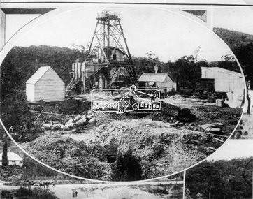
Photograph, The Australasian, Poppet-Head of the Caledonian Mine, the Warrandyte Gold Fields, 1906
... Poppet-Head of the Caledonian Mine, the Warrandyte Gold Fields ...Reproduced from "The Australasian" 12th May 1906, page 1115.This photo forms part of a collection of photographs gathered by the Shire of Eltham for their centenary project book,"Pioneers and Painters: 100 years of the Shire of Eltham" by Alan Marshall (1971). The collection of over 500 images is held in partnership between Eltham District Historical Society and Yarra Plenty Regional Library (Eltham Library) and is now formally known as the 'The Shire of Eltham Pioneers Photograph Collection.' It is significant in being the first community sourced collection representing the places and people of the Shire's first one hundred years.Digital image 35 mm Black and White negativesepp, shire of eltham pioneers photograph collection, warrandyte, gold mining -
 Eltham District Historical Society Inc
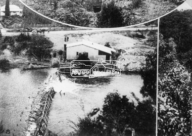
Photograph, The Australasian, The Caledonia Battery, the Warrandyte Gold Fields, 1906
... , the Warrandyte Gold Fields. Photograph Photograph The Australasian ...Reproduced from "The Australasian" 12th May 1906, page 1115.This photo forms part of a collection of photographs gathered by the Shire of Eltham for their centenary project book,"Pioneers and Painters: 100 years of the Shire of Eltham" by Alan Marshall (1971). The collection of over 500 images is held in partnership between Eltham District Historical Society and Yarra Plenty Regional Library (Eltham Library) and is now formally known as the 'The Shire of Eltham Pioneers Photograph Collection.' It is significant in being the first community sourced collection representing the places and people of the Shire's first one hundred years.Digital image 35 mm Black and White negativesepp, shire of eltham pioneers photograph collection, warrandyte, gold mining, caledonia battery, warrandyte battery -
 Orbost & District Historical Society
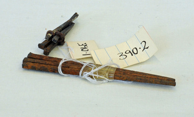
nails, 1890's
... to the Bendoc area gold fields. nails metal-working Temples-Store Two ...These hand-made nails were used in what was Temple's Store built in 1889. It later became Herbert's - now demolished and is the present site of the Foodworks Supermarket.Temple's store was on the corner of Ruskin Street and Nicholson Street. George Temple (1832-1918) established the store in about 1888. He packed stores to the Bendoc area gold fields.Two lots of hand-made nails. .1 is a set of five small nails tied together with string. .2 is a set of three longer nails which are very rusty.nails metal-working temples-store -
 Marysville & District Historical Society
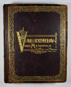
Book - Hardcover book, McCarron, Bird & Co, Victoria and its Metropolis-Past and Present-Volume 2, 1888
A history of the various colonies and districts of Victoria from the time of the discovery of Australia through until 1888.Hardback. Dark brown cover with the title in gold lettering. There is also a border in gold decorating the outer edge of the front cover. The spine is also decorated in gold along with the title and the volume number.non-fictionA history of the various colonies and districts of Victoria from the time of the discovery of Australia through until 1888.melbourne, victoria, pioneers, colonisation, history, fauna, flora, banking, finance, medicine, western district, south-western district, wimmera district, geelong district, ballarat district, avoca district, coliban district, campase district, loddon district, lower goulburn district, upper goulburn district, ovens district, north-east district, gippsland district, mornington district, westernport district, upper yarra district, evelyn district, bourke district -
 Marysville & District Historical Society
Document (item) - Report, Clement Wilks, Track to the River Jordan Gold Fields, 1864-1865
... of the gold fields road from Healesville to the Woods Point and Jordan ...A report by Mr Road Engineer Wilks on the construction of the Yarra Track in Victoria.A report by Mr Road Engineer Wilks on the construction of the Yarra Track in Victoria. The Yarra Track is the former name of the gold fields road from Healesville to the Woods Point and Jordan Goldfields, in Victoria, Australia. By Authority: JOHN FERRES, Government Printer, Melbourneclement wilks, yarra track, marysville, victoria, wood's point, healesville, jordan gold fields -
 Marysville & District Historical Society
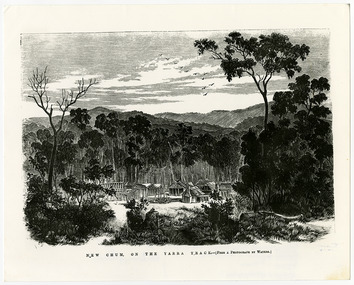
Work on paper (item) - Print of wood engraving, Frederick Grosse et al, New Chum on the Yarra Track, 27-09-1866
... in Victoria. The Yarra Track is the former name of the gold fields ...A copy of an early wood engraving taken from a photograph of the deserted township of New Chum, near Healesville, on the Yarra Track in Victoria.A copy of an early wood engraving taken from a photograph of the deserted township of New Chum, near Healesville, on the Yarra Track in Victoria. The Yarra Track is the former name of the gold fields road from Healesville to the Woods Point and Jordan Goldfields in Victoria.new chum, healesville, yarra track, victoria, frederick grosse, albert charles cooke, thomas waters, wood engraving -
 Marysville & District Historical Society
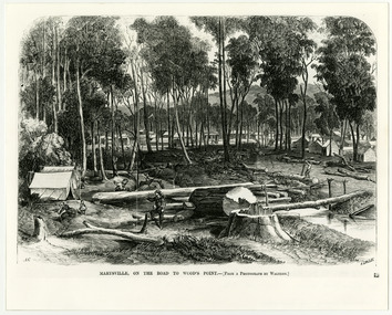
Work on paper (item) - Print of wood engraving, Frederick Grosse et al, Marysville, on the road to Wood's Point, 27-11-1866
... is the former name of the gold fields road from Healesville to the Woods ...A copy of an early wood engraving taken from a photograph of the township of Marysville in Victoria.A copy of an early wood engraving taken from a photograph of the township of Marysville in Victoria. The Yarra Track is the former name of the gold fields road from Healesville to the Woods Point and Jordan Goldfields in Victoria.victoria, frederick grosse, albert charles cooke, thomas waters, wood engraving, marysville, wood's point road -
 Marysville & District Historical Society
Photograph (Item) - Black and white photograph, Yarra Track Hotel, c1900
... . The Yarra Track is the former name of the gold fields road from ...An early black and white photograph of a hotel along the Yarra Track.An early black and white photograph of a hotel along the Yarra Track. The Yarra Track is the former name of the gold fields road from Healesville to the Woods Point and Jordan Goldfields, in Victoria, Australia. A direct route via the Yarra River and the Great Divide was discovered by Rieck in September 1862 and became known as the Yarra Track. Early in 1863, the Victorian Government decided to construct a 193-kilometre (120 mile) road along the route. Its original width varied between 4 and 6 metres (12 and 20 feet), and was designed to accommodate horse-drawn vehicles. The Track involved the climbing of the Black Spur, descent into the Acheron Valley, and then through Marysville to the Cumberland where it followed the existing route. Unable to ascertain both the location and name of hotel.ARMSTRONG COLLECTION 42 STATION STREET/ SANDRINGHAM 3191/ TEL. (03) 9521 5442/ IAN M.L. ARMSTRONG OAMyarra track, healesville, wood's point, jordan goldfields, victoria, yarra river, great divide, reick, black spur, acheron valley, marysville, cumberland creek -
 Marysville & District Historical Society
Photograph (Item) - Black and white photograph, The "Scandinavians' - (Deserted), c1900
... Track is the former name of the gold fields road from ...An early black and white photograph of The Scandinavian's Hotel and Boarding House along the Yarra Track.An early black and white photograph of The Scandinavian's Hotel and Boarding House along the Yarra Track. The Yarra Track is the former name of the gold fields road from Healesville to the Woods Point and Jordan Goldfields, in Victoria, Australia. A direct route via the Yarra River and the Great Divide was discovered by Rieck in September 1862 and became known as the Yarra Track. Early in 1863, the Victorian Government decided to construct a 193-kilometre (120 mile) road along the route. Its original width varied between 4 and 6 metres (12 and 20 feet), and was designed to accommodate horse-drawn vehicles. The Track involved the climbing of the Black Spur, descent into the Acheron Valley, and then through Marysville to the Cumberland where it followed the existing route.ARMSTRONG COLLECTION 42 STATION STREET/ SANDRINGHAM 3191/ TEL. (03) 9521 5442/ IAN M.L. ARMSTRONG OAMthe scandinavians', yarra track, healesville, wood's point, jordan goldfields, victoria, yarra river, great divide, reick, black spur, acheron valley, marysville, cumberland creek -
 Marysville & District Historical Society
Photograph (Item) - Black and white photograph, Camp Opposite The "Scandinavians', c1900
... is the former name of the gold fields road from Healesville to the Woods ...An early black and white photograph of a camp which was opposite The Scandinavian's Hotel and Boarding House along the Yarra Track.An early black and white photograph of a camp which was opposite The Scandinavian's Hotel and Boarding House along the Yarra Track. The Yarra Track is the former name of the gold fields road from Healesville to the Woods Point and Jordan Goldfields, in Victoria, Australia. A direct route via the Yarra River and the Great Divide was discovered by Rieck in September 1862 and became known as the Yarra Track. Early in 1863, the Victorian Government decided to construct a 193-kilometre (120 mile) road along the route. Its original width varied between 4 and 6 metres (12 and 20 feet), and was designed to accommodate horse-drawn vehicles. The Track involved the climbing of the Black Spur, descent into the Acheron Valley, and then through Marysville to the Cumberland where it followed the existing route.ARMSTRONG COLLECTION 42 STATION STREET/ SANDRINGHAM 3191/ TEL. (03) 9521 5442/ IAN M.L. ARMSTRONG OAMthe scandinavians', yarra track, healesville, wood's point, jordan goldfields, victoria, yarra river, great divide, reick, black spur, acheron valley, marysville, cumberland creek -
Marysville & District Historical Society
Document (Item) - Research Document, Judith Vimpani, William Cavanagh Farrell (1844-1901), 04-2020
... Track is the former name of the gold fields road from ...An account of the life of William Cavanagh Farrell.An account of the life of William Cavanagh Farrell who was important to Marysville as his review in 1863 of the routes to Wood's Point led to the Yarra Track ascending the Black Spur and going on to what became the resort town of Marysville on the Steavenson River. The Yarra Track is the former name of the gold fields road from Healesville to the Woods Point and Jordan Goldfields, in Victoria, Australia. A direct route via the Yarra River and the Great Divide was discovered by Reick in September 1862 and became known as the Yarra Track. Early in 1863, the Victorian Government decided to construct a 193-kilometre (120 mile) road along the route. Its original width varied between 4 and 6 metres (12 and 20 feet), and was designed to accommodate horse-drawn vehicles. The Track involved the climbing of the Black Spur, descent into the Acheron Valley, and then through Marysville to the Cumberland where it followed the existing route.willaim cavanagh farrell, marysville, victoria, wood's point, yarra track, black spur, steavenson's creek, steavenson river, george theodore rieck -
Marysville & District Historical Society
Document (Item) - Research Document, Judith Vimpani, George Theodore Rieck (1833-pos 1884), 04-2020
... Theodore Rieck. The Yarra Track is the former name of the gold ...An account of the life of George Theodore Rieck.An account of the life of George Theodore Rieck. The Yarra Track is the former name of the gold fields road from Healesville to the Woods Point and Jordan Goldfields, in Victoria, Australia. A direct route via the Yarra River and the Great Divide was discovered by Rieck in September 1862 and became known as the Yarra Track. Early in 1863, the Victorian Government decided to construct a 193 kilometre (120 mile) road along the route. Its original width varied between 4 and 6 metres (12 and 20 feet), and was designed to accommodate horse-drawn vehicles. The Track involved the climbing of the Black Spur, descent into the Acheron Valley, and then through Marysville to the Cumberland where it followed the existing route.george theordore rieck, marysville, victoria, james murphy, new chum creek, wood's point, gold mining, matlock, walhalla, yarra track -
Marysville & District Historical Society
Booklet (Item) - Information booklet, Artworkz Tourism, The Big Culvert, Unknown
... the road. The Yarra Track is the former name of the gold fields ...An information booklet that was produced as a guide to The Big Culvert.An information booklet that was produced as a guide to The Big Culvert. The Big Culvert is a historic granite and bluestone arch along the Yarra Track, a major route to Melbourne through the 1800s. Built in 1870 and a major piece of infrastructure for its time, the heritage listed culvert allowed water to flow under often-flooded the road. The Yarra Track is the former name of the gold fields road from Healesville to the Woods Point and Jordan Goldfields, in Victoria, Australia. A direct route via the Yarra River and the Great Divide was discovered by Rieck in September 1862 and became known as the Yarra Track. Early in 1863, the Victorian Government decided to construct a 193-kilometre (120 mile) road along the route. Its original width varied between 4 and 6 metres (12 and 20 feet), and was designed to accommodate horse-drawn vehicles. The Track involved the climbing of the Black Spur, descent into the Acheron Valley, and then through Marysville to the Cumberland where it followed the existing route.the big culvert, yarra track, victoria, healesville, wood's point goldfields, jordan goldfields, black spur, acheron valley, cumberland valley -
Marysville & District Historical Society
Flyer (Item) - Information flyer, Artworkz Tourism, The Big Culvert, 26-03-2016
... . The Yarra Track is the former name of the gold fields road from ...An information flyer that was produced as a guide to The Big Culvert.An information flyer that was produced as a guide to The Big Culvert. The Big Culvert is a historic granite and bluestone arch along the Yarra Track, a major route to Melbourne through the 1800s. Built in 1870 and a major piece of infrastructure for its time, the heritage listed culvert allowed water to flow under often-flooded the road. The Yarra Track is the former name of the gold fields road from Healesville to the Woods Point and Jordan Goldfields, in Victoria, Australia. A direct route via the Yarra River and the Great Divide was discovered by Rieck in September 1862 and became known as the Yarra Track. Early in 1863, the Victorian Government decided to construct a 193-kilometre (120 mile) road along the route. Its original width varied between 4 and 6 metres (12 and 20 feet), and was designed to accommodate horse-drawn vehicles. The Track involved the climbing of the Black Spur, descent into the Acheron Valley, and then through Marysville to the Cumberland where it followed the existing route.the big culvert, yarra track, victoria, healesville, wood's point goldfields, jordan goldfields, black spur, acheron valley, cumberland valley -
 Marysville & District Historical Society
Photograph (Item) - Black and white photograph, Unknown
... is the former name of the gold fields road from Healesville to the Woods ...A black and white photograph taken at the unveiling of the sign placed at The Big Culvert.A black and white photograph taken at the unveiling of the sign placed at The Big Culvert. The Big Culvert is a historic granite and bluestone arch along the Yarra Track, a major route to Melbourne through the 1800s. Built in 1870 and a major piece of infrastructure for its time, the heritage listed culvert allowed water to flow under often-flooded the road. The Yarra Track is the former name of the gold fields road from Healesville to the Woods Point and Jordan Goldfields, in Victoria, Australia. A direct route via the Yarra River and the Great Divide was discovered by Rieck in September 1862 and became known as the Yarra Track. Early in 1863, the Victorian Government decided to construct a 193-kilometre (120 mile) road along the route. Its original width varied between 4 and 6 metres (12 and 20 feet), and was designed to accommodate horse-drawn vehicles. The Track involved the climbing of the Black Spur, descent into the Acheron Valley, and then through Marysville to the Cumberland where it followed the existing route.Unveiling of sign/ at "Big Culvert" In front Max Cockerrell and - Rear: second back Geoff Pope R.H.S. rear: Nancy "/ Anne "the big culvert, yarra track, victoria, healesville, wood's point goldfields, jordan goldfields, black spur, acheron valley, cumberland valley -
 Marysville & District Historical Society
Photograph (Item) - Colour photograph, 20-09-2008
... is the former name of the gold fields road from Healesville to the Woods ...A colour photograph of the entrance to The Big Culvert.A colour photograph of the entrance to The Big Culvert. The Big Culvert is a historic granite and bluestone arch along the Yarra Track, a major route to Melbourne through the 1800s. Built in 1870 and a major piece of infrastructure for its time, the heritage listed culvert allowed water to flow under often-flooded the road. The Yarra Track is the former name of the gold fields road from Healesville to the Woods Point and Jordan Goldfields, in Victoria, Australia. A direct route via the Yarra River and the Great Divide was discovered by Rieck in September 1862 and became known as the Yarra Track. Early in 1863, the Victorian Government decided to construct a 193-kilometre (120 mile) road along the route. Its original width varied between 4 and 6 metres (12 and 20 feet), and was designed to accommodate horse-drawn vehicles. The Track involved the climbing of the Black Spur, descent into the Acheron Valley, and then through Marysville to the Cumberland where it followed the existing route.the big culvert, yarra track, victoria, healesville, wood's point goldfields, jordan goldfields, black spur, acheron valley, cumberland valley -
 Federation University Historical Collection
Book, Nathaniel Frank, Introduction to Electricity and Optics, 1950
Dark Blue synthetic hard caver book of 440 pages with gold lettering embossed on the spine. non-fictionelectricity, optics, force, electrostatic, charg and capacity, electric currents, magnetic field, alternating current circuits, electromagnetic waves, radiation, conduction, dielectrics, geometrical optics, interference, heat radiation, diffraction -
 Flagstaff Hill Maritime Museum and Village
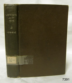
Book, Lasseters Last Ride
About Ion L Idriess Ion Llewellyn Idriess was born in Waverley, Sydney, New South Wales on 20th September 1889 and passed away on 6th June 1979 in Mona Vale, Sydney, New South Wales at the age 89. After Idriess finished school he worked in the assay office of Broken Hill Proprietary mine. Both Idriess and his mother had typhoid fever when Ion was about 15 years old and it caused his mother’s death. After spending time with his Grandmother in Sydney he found work on a paddle-steamer and had a relapse of the fever. He then went into the western district of New South Wales where he worked in many different itinerant jobs, including rabbit poisoner, boundary rider, drover, sandalwood harvester, shearer, dingo shooter and opal miner. While opal mining at Lightning Ridge he wrote short stories, about life on the opal fields, for the Bulletin using the name “Gouger”. Idriess then moved to North Queensland in search of gold, tin and sandalwood. He travelled over a great deal of the Cape York Peninsula spending a lot of this travel time with local indigenous people; thus began his lifelong interest in their customs. He then spent time on cattle stations in the Gulf of Carpentaria. In 1914 Idriess travelled to Townsville and enlisted in the 5th Light Horse as a trooper. He became a specialist in sniping and was a spotter for the noted sniper Billy Sing. He saw service in Palestine, Sinai and Turkey. Idriess was wounded at Beersheba and after fighting the Battle of Gaza he was invalided home in March 1918. After recovering from his wounds Idriess again travelled to Cape York Peninsula where he worked with pearlers and missionaries in the Torres Strait Islands. He then went gold mining in Papua New Guinea, buffalo shooting in the Northern Territory of Australia and then exploring in Central and Western Australia. LITERARY WORKS OF IDRIESS In 1928 Idriess settled in Sydney and published the first of his 47 books. In 1931 - “Lasseter’s Last Ride”, became his first best seller. In the years 1932 and 1940 he published three books in each year. “The Cattle King” (1936) and “Flynn of the Inland” (1932) have gone through reprinting forty to fifty times. His last book was published in 1969. Idriess’ books where in general non-fiction and were written in a colourful and immediate story style, taken from life experiences gained during his travels. Idriess was appointed an Officer of the Most Excellent Order of the British Empire (OBE) for his service to literature in 1968. Warrnambool Public Library The Warrnambool Mechanics’ Institute (WMI) was formed by a voluntary community group in 1863, within six years of Warrnambool’s beginnings, and its Reading Room opened in 1854. The WMI operated until 1963, at which time it was one of the oldest Mechanics’ Institutes in Victoria. Mechanics’ Institutes offered important services to the public including libraries, reading rooms and places to display and store collections of all sorts such as curiosities and local historical relics. In 1886 a Museum and Fine Arts Gallery were added to the WMI and by the beginning of the 20th century there was also a billiards room and a School of Art. By this time all Mechanics’ Institutes in country Victoria had museums attached. Over the years the Warrnambool Mechanics’ Institute Library was also known as the Warrnambool Public Library the Warrnambool Library and the Free Library. Early funding from the government was for the “Free Library”. The inscription in a book “Science of Man” was for the “Warrnambool Public Library”, donated by Joseph Archibald in 1899. Another inscription in the book “Catalogue of Plants Under Cultivation in the Melbourne Botanic Gardens 1 & 2, 1883” was presented to the “Warrnambool Library” and signed by the author W.R. Guilfoyle. In 1903 the Warrnambool Public Library decided to add a Juvenile Department to library and stock it with hundreds of books suitable for youth. In 1905 the Public Library committee decided to update the collection of books and added 100 new novels plus arrangements for the latest novels to be included as soon as they were available in Victoria. In July 1911 the Warrnambool Council took over the management of the Public Library, Art Gallery, Museum and Mechanics’ Institute and planned to double the size of the then-current building. In 1953, when Mr. R. Pattison was Public Librarian, the Warrnambool Public Library’s senior section 10,000 of the 13,000 books were fiction. The children’s section offered an additional 3,400 books. The library had the equivalent of one book per head of population and served around 33 percent of the reading population. The collection of books was made up of around 60 percent reference and 40 percent fiction. The library was lending 400 books per day. In 1963 the Warrnambool City Council allocated the site of the Mechanics’ Institute building, which included the Public Library, Museum and Art Gallery, for the new Municipal Offices and the Collections were dispersed until 1971. The Warrnambool Library took over the Mechanics’ Institute Library’s holdings on behalf of the Warrnambool City Council. Since the closure of the Warrnambool Mechanics’ Institute the exact location and composition of the original WMI books and items has become unclear. Other materials have been added to the collection, including items from Terang MI, Warrnambool Court House and Customs House. Many of the books have been identified as the Pattison Collection, named after the Librarian who catalogued and numbered the books during his time as Warrnambool Public Librarian in the time before the Mechanics’ Institute closed. It seems that when Warrnambool became part of the Corangamite Regional Library some of the books and materials went to its head office in Colac and then back to Warrnambool where they were stored at the Art Gallery for quite some time. Some then went to the Warrnambool Historical Society, some stayed at the Art Gallery and some were moved to Flagstaff Hill Maritime Village. The various stamps and labels on the books held at Flagstaff Hill show the variety of the collection’s distribution and origin. The books in the collection at Flagstaff Hill Maritime Village date from the 1850’s to the late 1950’s and include rare and valuable volumes. Many of the books are part of the “Pattison Collection” after the Warrnambool’s Public Librarian, Mr. R. Pattison SIGNIFICANCE The Warrnambool Mechanics' Institute Collection is primarily significant in its totality, rather than for the individual objects it contains. Its contents are highly representative of the development of Mechanics' Institute libraries across Australia, particularly Victoria. A diversity of publications and themes has been amassed, and these provide clues to our understanding of the nature of and changes in the reading habits of Victorians from the 1850s to the middle of the 20th century. The collection also highlights the Warrnambool community’s commitment to the Mechanics’ Institute, and to reading, literacy and learning in the regions, and proves that access to knowledge was not impeded by distance. These items help to provide a more complete picture of our community’s ideals and aspirations. As with many Mechanics' Institutes in Australia, the one which operated in Warrnambool was established and overseen for many years by key individuals associated with the development of the city itself. The WMI publication collection is historically significant because of its association with local people, places and the key historical themes in the development of Warrnambool of rural development, industry, farming, education, and community. The collection documents and illustrates the changing interests, focus and tastes of Victorians, especially those in regional cities. Generally the individual items in the collection are not particularly rare, as examples of all probably exist in other public collections in Victoria. It is primarily because there are so very few surviving Mechanics' Institute collections in Victoria, which lends this overall collection its significance. Many items in the WMI Collection have the potential to support further research, both as individual objects and through the collection in its entirety. This material is significant for its ability to assist in the interpretation of the history of the area and adds to the general understanding of the development of the township. Many components of the WMI publication collection complement and reinforce the Flagstaff Hill Maritime Museum Collection, the Warrnambool Art Gallery Collection, and that in the Warrnambool Historical Society, and also contribute to a clearer understanding of the original Warrnambool Mechanics' Institute collections. This will greatly enhance the appreciation of the few surviving Mechanics' Institute collections across Victoria, and also in New South Wales. The similarities and differences between the small number of collections that have survived can provide further insights into how the people of Victoria in general, and Warrnambool in particular, constructed a civic culture of adult learning to foster an informed citizenry. The Warrnambool Mechanics' Institute publication collection is of both local and state significance. Lasseters Last Ride First published in 1931 Author: Ion Idriess Publisher: Angus & Robertson Label on spine with typed text R.A. 994.03 IDR warrnambool, shipwrecked-coast, flagstaff-hill, flagstaff-hill-maritime-museum, maritime-museum, shipwreck-coast, flagstaff-hill-maritime-village, shipwrecked-artefact, great ocean road, book, warrnambool library, warrnambool mechanics’ institute, mechanics’ institute library, victorian library board, warrnambool books and records, warrnambool children’s library, warrnambool public library, lasseters last ride, ion idriess, indigenous people -
Glen Eira Historical Society
Article - LONG, JOHN
This file contains two items: 1/A photocopied carbon copy detailing Robert Marriott and John Long from their arrival in Victoria. It notes that both became councillors in the City of St. Kilda and where they lived. 2/Photocopied photo from ‘Sand, Swamp and Heath’ of Caulfield Borough Council, 1901. Includes John Long, page 24.marriott robert, long john, gold, caulfield, councillors, st. kilda, hawthorn road, alexander hospital, hospitals, flowers street, laura street, glenhuntly road, marriott john, bambra road, field street -
Glen Eira Historical Society
Letter - MARRIOTT FAMILY
This file contains three items of this family’s correspondence 1/A Carbon copy page giving details of Robert and John Marriott and John Long, from their arrival in Victoria. Includes brief history of their lives becoming councillors for the city of Caulfield. Also Robert’s early market garden business in the area, and how he established Camden Town Methodist Church. 2/A handwritten letter to Mr. Murray from Catherine Marriott dated 29th Oct (no year) 3/A Two handwritten pages of working notes in Peter Murray’s writing, author for ‘Sand, Swamp and Heath’.marriot robert, long john, gold, caulfield, councillors, st. kilda, hawthorn road, alexandra hospital, hospitals, flowers street, laura street, glen huntly road, marriot john, bambra road, field street, goe street, market gardeners, bentleigh, marriott thomas, methodist church, sunday schools, camden, hawthorn road, indoor bowling club, sporting clubs, lewis bobby, jockeys, marriott catherine, marriott arthur, hughes d, blanche mrs., stables, kooyong road, ricketson h, mallinson j, kunney m, evans john, grange road, millar w, nyora road, rate book