Showing 1315 items
matching growth
-
 Eltham District Historical Society Inc
Folder, Short History of the Municipality of Eltham, 1981
Document from unknown author. Sections include: Constitutional history, population growth including ABS data 1943- 1978, notes on the European history of Eltham - about your Council - schools - list of historical buildings. Copy also held at Yarra Plenty Regional Library (Eltham Library). Possibly produced as a resource for students. Also includes single page headed Heritage Week 1983, rural townships, page 3 with refernece to key buildings in Eltham township.30 pages, typed textHG Booklet 17harry gilham collection, pioneers of eltham, population, shire of eltham -
 Federation University Historical Collection
Photographs - black and white, Henry John (Jack) Holmes of Ascot and Derrinallum, Victoria
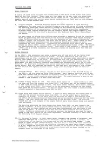
Henry John (Jack) Holmes of Ascot was the eldest son of Henry Smerdon and Edith (nee Pickford) Holmes and brother to William Smerdon [Bill], David Coghill and Elizabeth (m Chatham) On his return from serving in WW2, Jack with his father's help took up a Soldier Settler option and settled at Derrinallum on a portion of Mout Elephant. The holding was named "Launchley Park". Soldiers, like Jack with their families, helped swell the numbers in the district and aided the growth in the town and the services it could provide.Three photographs. .1) Black and white photograph of Henry John (Jack) Holmes from Ascot and then Derinallum .2) and .3) Jack Holmes. jack holmes, chatham-holmes collection, henry smerdon holmes, derrinallum, western desert ww2, soldier settlement, mount elephant -
 Sunshine and District Historical Society Incorporated
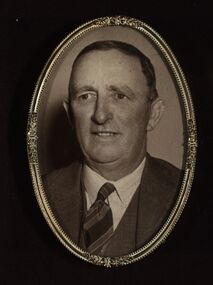
Plaque, A. H. Walker, COAT OF ARMS - Shire of Braybrook Victoria, Unknown date of manufacture
From around circa 1850 Braybrook was already well established and became a staging point for prospectors on their way to the diggings. Local government for this rural area to the west of Melbourne came when the BRAYBROOK ROAD DISTRICT was proclaimed on 28 May 1860. This authority was superseded on 23 January 1871 with the formation of the SHIRE OF BRAYBROOK. The Shire of Braybrook existed for about 80 years during which time it experienced significant industrial growth. The Shire of Braybrook ceased to exist in 1951 when the CITY OF SUNSHINE was formed.The Coat of Arms informs the observer that the Shire of Braybrook was initially a rural area with its images of a cow, sheep, and hay. The reference to industry however probably does not indicate adequately the large growth in industrial activity that occurred within the Shire. Circular board of Masonite painted by A. H. Walker which is a true depiction of the Coat of Arms for the Shire of Braybrook. It is mainly blue, yellow and red coloured with black writing, and has images of a cow, sheep, and hay, and also indicates a reference to industry.Shire of Braybrook Victoria / Dieu Et Mon Droit / By Industry / A. H. Walkercoat of arms, shire of braybrook, a. h. walker, plaque, sunshine -
 Kew Historical Society Inc
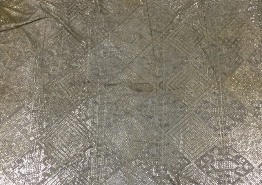
Clothing - Silver Tinsel Yarn on Tulle Scarf, 1970s
The Fashion & Design collection of Kew Historical Society includes examples of textiles dating from the 18th, 19th and 20th centuries. Some of the textiles, were used as items of clothing, others as items of household decoration, or simply as travel souvenirs. These textiles were created both domestically and internationally. Predictably with the growth of an ethnically and culturally more diverse community in Kew after the Second World War, textiles, clothing and objects in the collection inevitably reflected this diversity. The item was purchased and donated by Rosemary Vaughan-Smith.A tulle scarf using beaten silver tinsel yarn on a net base, with pattern of lozenges, from Baalbek (Lebanon)scarfs, metal-thread weaving, lebanese textiles, rosemary vaughan-smith -
 Australian Nursing & Midwifery Federation
29-minute video documentary on the history of the Victorian nurses union, Australian Nursing & Midwifery Federation (Victorian Branch), The rise and rise of the Victorian nurses' union, 2006
The short documentary 'The rise and rise of the Victorian nurses' union' was released on DVD only in 2006. It tells the story of the Branch from its inception, charting major industrial and professional developments for nurses in Victoria over the past century. In particular, it focuses on the shortage of nurses that Victoria experienced from the 1970s to the 1990s, the removal of the 'no-strike' clause from the organisation's rules, the resultant historic 50-day 1986 Victorian nurses' strike and the growth in membership in the context of overall declining union membership in Australia.29 minute video file (.mp4 multimedia format), transferred from original DVD. In colour, with sound. Original distributed (not sold) on DVD.nursing, ratios, 1986 victorian nurses strike, industrial action, industrial relations, labour history, staffing, unionism, nurses, campaigning, organising, documentaries, feminism, victoria, australia -
 St Kilda Historical Society
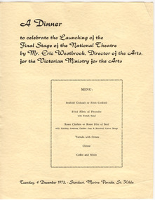
Ephemera - Menu, A Dinner to Celebrate the Launching of the Final Stage of the National Theatre, 1973
Contains information about the formation and growth of the National Theatre Movement and statistics about the construction of the new National Theatre in the building formerly known as the Victory Theatre, on the corner of Carlisle and Barkly Streets, St Kilda. A dinner to launch the final stage of construction was held on 4 December 1973. Completion was planned for 15 June 1974 and the official opening date was to be 24 August 1974. The dinner was hel at the Stardust, Marine Parade, St Kilda and was hosted by the Victorian Ministry for the Arts.Yellow coloured card printed in black on one side and brown on the othernational theatre, stardust -
 Southern Sherbrooke Historical Society Inc.
Information folder - Margaret Douglas
Information folder containing items pertaining to Margaret Douglas. Contents: -article, 'A life of growth for Sister Margaret', Knox Easterly, 22 October 1986 2 original copies, 1 photocopy) -articles, "Sense of community', 'Resident doctor', 'The Angliss Hospital - through the years', Mail, 10 June 2014 -order of service, funeral of Margaret Shirley Douglas, Blair Chapel, Springvale Botanical Cemetery, Friday 16th April 2010 -eulogy (by nephew, who conducted service) -Article, The Age, "Artist of Crazy Man's Creek: A portrait", circa 1996. -Article, Free Press, "Cr Margaret 'worked quietly', 28-9-1983. -Article, The Leader (?), "Oft, the best leave", undated (but after 1995). -Article, Knox-Sherbrooke news, "Sister Douglas still cares", 25-8-1987. -
 Kew Historical Society Inc
Work on paper, Alan Sumner, Preparatory Drawing for 'The Four Seasons' Window, 1985
The gouache was presented to Cr Jill O'Brien, Mayor of Kew in 1983-4, who was instrumental in the purchase of the window. The same Kewriosity article, referred to in the physical description, states that the window was originally commissioned from the artist by a Kew timber merchant, and following ownership by successive owners found its way back to Kew. The framed photograph is part of the Jill O'Brien collection which was gifted to the Kew Historical Society following her death in July 2016. The collection includes important primary sources relating to a number of areas in which Jill O'Brien made a significant contribution including the establishment of the Villa Alba Museum, local government, the Kew Historical Society, the Yarra Bend Trust, and the arts.Framed gouache on paper of the design by the artist Alan Sumner for his window, The Four Seasons. The window, now in Kew Library was purchased to commemorate Kew's 125th Anniversary. An article in a contemporary issue of Kewriosity states: The window is approximately three metres in diameter and divided into one central and four outer panels. Clockwise from the top is Autumn with sinuous lines in yellow and brown, then winter in cool blues and mauves with lines and circles suggesting rain, snow and hail. Spring follows in the bottom left quadrant with organic ovaloid shapes richly coloured and lines evoking growth. Then to the top where summer explodes with the colours of fire and blue of the sky at the height of summer. The centre panel has a powerful image of sun, moon and stars which links the surrounding panels".jill o’brien, public art - kew (vic), stained glass - kew (vic), alan sumner - the four seasons, kew library, public art -
 Melbourne Tram Museum
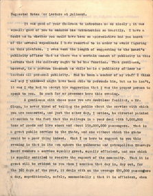
Document - Lecture Notes, Melbourne & Metropolitan Tramways Board (MMTB), "Suggested Notes for Lecture at Jolimont", Jun. 1930
Lecture Notes - 12 quarto sheets and 1 foolscap memo - carbon copy titled "Suggested Notes for Lecture at Jolimont". May have been presented by the Chief Engineer, given the memory dated 17 June 1930. Notes drafted by Lewis Russell the MMTB Publicity Officer. Refers to Mr. O'Meara and Mr. Moody in the memo. Has notes on the VR view of the MMTB, Notes Mr. Harold Clapp. tramway operations, cable trams, tram car No. 1, the Powers of the Tramways Act, MTOCo, MTT, finances, the various tramway trusts, tram services to service population growth, the General Scheme, cable tram conversion, St Kilda Road, Reserved track, conversion work, the time taken to do the work and Preston Workshops. Also has a list of suggested slides.trams, tramways, mmtb, workshops, cable trams, st kilda rd, conversion, general scheme, reserved track -
 Flagstaff Hill Maritime Museum and Village
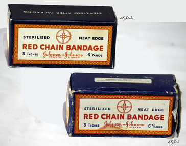
Equipment - Ribbon Gauze & Box, Johnson & Johnson Pty Ltd
Most surgical wounds are closed primarily, but some are allowed to heal by secondary intention. This usually involves repeated packing and dressing of the raw wound surfaces. Although the long-term care of such wounds has devolved to the care of nurses in the community or out-patient setting, the initial wound dressing or cavity packing is done by the surgeon in the operating theatre. Many surgeons are unaware of the growth of the discipline of wound care, and still use traditional soaked gauze for dressing and packing open surgical wounds and cavities. https://www.ncbi.nlm.nih.gov/pmc/articles/PMC1963638/The control of bleeding and wound management is vitally important for the survival of the patient.Gauze bandage and cardboard box.Two boxes. One box in better condition. Red Chain Bandage. Johnson and Johnson Pty Ltd Sydney. 3 inches, 6 yards. Sterilized neat edge.flagstaff hill, warrnambool, shipwrecked-coast, flagstaff-hill, flagstaff-hill-maritime-museum, maritime-museum, shipwreck-coast, flagstaff-hill-maritime-village, "red chain bandage", gauze, bandage, johnson & johnson -
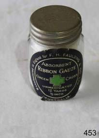 Flagstaff Hill Maritime Museum and Village
Equipment - Glass Jar, F H Faulding
Most surgical wounds are closed primarily, but some are allowed to heal by secondary intention. This usually involves repeated packing and dressing of the raw wound surfaces. Although the long-term care of such wounds has devolved to the care of nurses in the community or out-patient setting, the initial wound dressing or cavity packing is done by the surgeon in the operating theatre. Many surgeons are unaware of the growth of the discipline of wound care, and still use traditional soaked gauze for dressing and packing open surgical wounds and cavities. https://www.ncbi.nlm.nih.gov/pmc/articles/PMC1963638/ The control of bleeding and wound management is vitally important for the survival of the patient.Clear glass round jar and lid, with heavy metal screw turning. Contains 12 yards of 1/2 unmedicated absorbent ribbon gauze.Manufactured in England for F H Faulding & Co Ltd. Absorbent Ribbon Gauze. Green Cross. Unmedicated. 12 yards. ½ inch.flagstaff hill, warrnambool, shipwrecked-coast, flagstaff-hill, flagstaff-hill-maritime-museum, maritime-museum, shipwreck-coast, flagstaff-hill-maritime-village, medical, ribbon gauze, faulding -
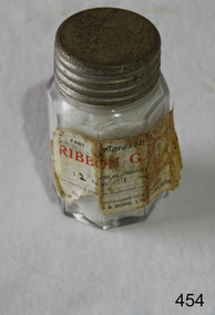 Flagstaff Hill Maritime Museum and Village
Equipment - Glass Jar, Amuson
Most surgical wounds are closed primarily, but some are allowed to heal by secondary intention. This usually involves repeated packing and dressing of the raw wound surfaces. Although the long-term care of such wounds has devolved to the care of nurses in the community or out-patient setting, the initial wound dressing or cavity packing is done by the surgeon in the operating theatre. Many surgeons are unaware of the growth of the discipline of wound care, and still use traditional soaked gauze for dressing and packing open surgical wounds and cavities. https://www.ncbi.nlm.nih.gov/pmc/articles/PMC1963638/The control of bleeding and wound management is vitally important for the survival of the patient.Clear glass jar containing gauze bandage, entitled "Ribbon Gauze" for plugging. Trade name "Amuson". Label badly damaged. Lid is metal with heavy turning. Appears to be well corroded. Octagonal shaped bottle.Amuson. Adelaide. 'Ribbon gauze for plugging.'flagstaff hill, warrnambool, shipwrecked-coast, flagstaff-hill, flagstaff-hill-maritime-museum, maritime-museum, shipwreck-coast, flagstaff-hill-maritime-village, medical, ribbon gauze, amuson -
 Eltham District Historical Society Inc
Photograph, Barnes Railway Station, Moama, NSW, c.November 1962, 1962
The railway reached Echuca in 1864 and transformed the town into a major river port, with a famous wharf and substantial urban growth in the 1870s. In 1876 the Deniliquin and Moama Railway Company opened its 71 km (44 mi) private railway northwards to Barnes and Deniliquin, and the line at Echuca was extended across the Murray River into Moama to join the railway. This section was taken over by Victorian Railways in 1923, as part of the 1922 Border Railways Act. Barnes station was closed in 1979. Deniliquin railway line https://en.wikipedia.org/wiki/Deniliquin_railway_lineDigital TIFF file Scan of 35mm Ilford FP3 black and white negative transparencybarnes railway station, echuca, george coop collection, moama -
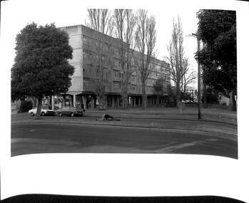 Port Melbourne Historical & Preservation Society
Photograph - Raglan Street Housing Commission Flats viewed from Crockford Street, Andrew U'REN, C. 1970s - 1980s
From a box of photographs in Nancy U'REN's papers used during research for her thesis, The Early Growth and Development of Sandridge (1976) and/or her book with Noel TURNBULL, A History of Port Melbourne (1983). The print was probably made by her son, Andrew U'REN, and he may have also taken the photograph. The photograph includes two people on the median strip. It is unclear what they are doing or what has happened just before the photograph was taken. One person is kneeling closely over the other who appears to be lying on their back.Black and white photograph of the Raglan Street Housing Commission flats at the corner of Ingles and Crockford Streets viewed from Crockford Street. Large white border at the bottom.Details of photographic paper type and exposure details in blue ink on the reverse.built environment - public housing, ingles street, crockford street, raglan street housing commission of victoria flats, built environment - domestic, nancy u'ren nee morris -
 Kew Historical Society Inc
Photograph - Brick and Stucco Bungalow, J E Barnes, c.1920
The Kew Historical Society's map collection includes a substantial number of real estate subdivision plans, mainly of Kew but also of surrounding suburbs in Melbourne. Most of the subdivision plans date from the 1920s and 1930s when the districts old homes and local farmland were being split up to accommodate residential growth in the postwar period. These early plans were assembled by a local firm, Jas R Mather & McMillan, which had an office in Cotham Road. Many of the plans, and sometimes photos, were annotated by the agents.Subdivision plans are historically important documents used as evidence for the growth of suburbs in Australia. They frequently provide information about when the land was sold as well as evidence relating to surveyors and real estate and financial agents. The numerous subdivision plans in the Kew Historical Society's collection represent working documents, ranging from the initial sketches made in planning a subdivision to printed plans on which auctioneers or agents listed the prices for which individual lots were sold. In a number of cases, the reverse of a subdivision plan in the collection includes a photograph of a house that was also for sale by the agent. These photographs provide significant heritage information relating house design and decoration, fencing and household gardens.The photograph may also be aesthetically significant depending o the importance of the photographic atelier.Real estate photograph for a local agent by the Kew photographer, Josiah Earl Barnes. The photo is of a weatherboard or brick rendered bungalow with a twisted wire fence. Given Barnes' status a a Kew photographer, the house is probably locate din Kew or East Kew. Unfortunately the handwritten information on the mount bordering the photo is damaged and cannot be read. The bungalow has a gabled, tiled roof with terra cotta finials at the front of both gables. The house has a central doorway, framed by a pseudo portico supported by four wooden columns. On each side of the doorway, at the front, there are paired sash windows, which, like the half-timbered gable, are picked out in a darker colour.Handwritten, mostly illegible description by selling agent on mount surround: " .... in Diningroom, Drawing Rooms, ... Photographers details printed on mount: "J. E. Barnes / Photo / Phone 1966 Haw KEW"houses - kew, bungalows - kew, real estate photographs, j.e. barnes -- photographer -
 Kew Historical Society Inc
Photograph - Victorian Double-fronted Brock Villa, Cotham Road, c. 1919
The Kew Historical Society's map collection includes a substantial number of real estate subdivision plans, mainly of Kew but also of surrounding suburbs in Melbourne. Most of the subdivision plans date from the 1920s and 1930s when the districts old homes and local farmland were being split up to accommodate residential growth in the postwar period. These early plans were assembled by a local firm, Jas R Mather & McMillan, which had an office in Cotham Road. Many of the plans, and sometimes photos, were annotated by the agents.Subdivision plans are historically important documents used as evidence for the growth of suburbs in Australia. They frequently provide information about when the land was sold as well as evidence relating to surveyors and real estate and financial agents. The numerous subdivision plans in the Kew Historical Society's collection represent working documents, ranging from the initial sketches made in planning a subdivision to printed plans on which auctioneers or agents listed the prices for which individual lots were sold. In a number of cases, the reverse of a subdivision plan in the collection includes a photograph of a house that was also for sale by the agent. These photographs provide significant heritage information relating house design and decoration, fencing and household gardens.The photograph may also be aesthetically significant depending o the importance of the photographic atelier.Real estate photographs of a classic double-fronted late Victorian brick villa. It central location in Cotham Road, Kew enabled the selling agent to note its proximity to the tram. With seven rooms, all ‘modern conveniences’, and land of 66×167, the house was to be sold for £1100. The villa has a number of interesting features including a pattern within the slate roof as well as the use of polychrome brickwork under the eaves and on the façade. The intricacy of the cast iron lace is emphasised by the line of projecting wooden blocks above it. The picket gate is painted a different colour to the pickets of the fence. The house has a name (illegible) that is attached to the inset cast iron lace of the central projecting gable in the veranda. Stamped on mount: "Kew. Central. Close tram. / Comfortable Brick Villa. / Containing 7 rooms / Modern conveniences: / Land 66 x 167. Sold 1100 pounds:"houses - kew, victorian villas, real estate photographs, cotham road - kew -
 Kew Historical Society Inc
Photograph - Double-fronted Edwardian Villa, c.1918
The Kew Historical Society's map collection includes a substantial number of real estate subdivision plans, mainly of Kew but also of surrounding suburbs in Melbourne. Most of the subdivision plans date from the 1920s and 1930s when the districts old homes and local farmland were being split up to accommodate residential growth in the postwar period. These early plans were assembled by a local firm, Jas R Mather & McMillan, which had an office in Cotham Road. Many of the plans, and sometimes photos, were annotated by the agents.Subdivision plans are historically important documents used as evidence for the growth of suburbs in Australia. They frequently provide information about when the land was sold as well as evidence relating to surveyors and real estate and financial agents. The numerous subdivision plans in the Kew Historical Society's collection represent working documents, ranging from the initial sketches made in planning a subdivision to printed plans on which auctioneers or agents listed the prices for which individual lots were sold. In a number of cases, the reverse of a subdivision plan in the collection includes a photograph of a house that was also for sale by the agent. These photographs provide significant heritage information relating house design and decoration, fencing and household gardens.The photograph may also be aesthetically significant depending on the importance of the photographic atelier.On the reverse of a subdivision plan of the Palmyra Estate (Kew) is a photograph of a double-fronted Edwardian villa. The weatherboard and stucco house with high brick chimneys provides a clear indication of the style of curtains and gardens in houses of the period. Holland blinds with lace inserts are used in the left front window. They are combined with long lace curtains. The garden, with its curved pathway is bordered with garden beds that include marguerite daisies and roses. Reflecting a new interest in the Australian landscape, tree ferns and ground ferns are planted closer to the house.houses - kew, architecture - edwardian, real estate photographs -
 Kew Historical Society Inc
Plan - Subdivision : Cotham and Glenferrie Roads, J R Mathers & McMillan
The Kew Historical Society's map collection includes a substantial number of real estate subdivision plans, mainly of Kew but also of surrounding suburbs in Melbourne. Most of the subdivision plans date from the 1920s and 1930s when the districts old homes and local farmland were being split up to accommodate residential growth in the postwar period. These early plans were assembled by a local firm, Jas R Mather & McMillan, which had an office in Cotham Road. Many of the plans, and sometimes photos, were annotated by the agents.Subdivision plans are historically important documents used as evidence for the growth of suburbs in Australia. They frequently provide information about when the land was sold as well as evidence relating to surveyors and real estate and financial agents. The numerous subdivision plans in the Kew Historical Society's collection represent working documents, ranging from the initial sketches made in planning a subdivision to printed plans on which auctioneers or agents listed the prices for which individual lots were sold. In a number of cases, the reverse of a subdivision plan in the collection includes a photograph of a house that was also for sale by the agent. These photographs provide significant heritage information relating house design and decoration, fencing and household gardens.The photograph may also be aesthetically significant depending on the importance of the photographic atelier.An undated and untitled hand-drawn and coloured subdivision plan detailing the boundaries of a number of irregular allotments bordering Cotham Road, Glenferrie Road and Stirling Avenue (now Stirling Street). The plan predates the actual subdivision that led to the creation of the eight commercial properties occupying 118-132 Cotham Road. The plan may represent an old subdivision that was further subdivided at a later date, or it may be a subdivision that never eventuated. On MMBW Detail Plan 1575 (1903), the area represented by the proposed subdivision was residential rather than commercial. The irregularity of lots is also apparent in the MMBW Plan. The largest of the unnumbered blocks on the hand-drawn subdivision plan may relate to the boundaries of the nineteenth century mansion identified as ‘Kelso’ on the MMBW Plan.subdivision plans - kew, cotham road - kew,, glenferrie road - kew , stirling avenue street - kew -
 Kew Historical Society Inc
Photograph - Cottage, probably East Kew, A. Aberline, 1920s
The Kew Historical Society's map collection includes a substantial number of real estate subdivision plans, mainly of Kew but also of surrounding suburbs in Melbourne. Most of the subdivision plans date from the 1920s and 1930s when the districts old homes and local farmland were being split up to accommodate residential growth in the postwar period. These early plans were assembled by a local firm, Jas R Mather & McMillan, which had an office in Cotham Road. Many of the plans, and sometimes photos, were annotated by the agents.Subdivision plans are historically important documents used as evidence for the growth of suburbs in Australia. They frequently provide information about when the land was sold as well as evidence relating to surveyors and real estate and financial agents. The numerous subdivision plans in the Kew Historical Society's collection represent working documents, ranging from the initial sketches made in planning a subdivision to printed plans on which auctioneers or agents listed the prices for which individual lots were sold. In a number of cases, the reverse of a subdivision plan in the collection includes a photograph of a house that was also for sale by the agent. These photographs provide significant heritage information relating house design and decoration, fencing and household gardens.The photograph may also be aesthetically significant depending on the importance of the photographic atelier.An elevated, modest weatherboard house, photographed towards the end of the construction phase. The lower section of the weatherboards are exposed and stained. The upper section is rendered with rough-cast. The tiled roof has a single gable that extends over the centrally placed front porch. On the porch, the door and single sidelight are filled with coloured leadlight whereas the casement windows in the front rooms contain plain glass. The leadlight and the wrought iron of the verandah are the only decorative elements of the utilitarian design. The location of the house, which was advertised for sale, has not to date been identified. The real estate photograph is mounted on the reverse of a subdivision plan for the Harvest Home Estate, Kew East.Photographer's stamp, lower right on mount: "A. Aberline, Glenferrie"houses - kew, bungalows - kew, real estate photographs -
 Kew Historical Society Inc
Photograph - Bungalow, probably East Kew, 1920s
The Kew Historical Society's map collection includes a substantial number of real estate subdivision plans, mainly of Kew but also of surrounding suburbs in Melbourne. Most of the subdivision plans date from the 1920s and 1930s when the districts old homes and local farmland were being split up to accommodate residential growth in the postwar period. These early plans were assembled by a local firm, Jas R Mather & McMillan, which had an office in Cotham Road. Many of the plans, and sometimes photos, were annotated by the agents.Subdivision plans are historically important documents used as evidence for the growth of suburbs in Australia. They frequently provide information about when the land was sold as well as evidence relating to surveyors and real estate and financial agents. The numerous subdivision plans in the Kew Historical Society's collection represent working documents, ranging from the initial sketches made in planning a subdivision to printed plans on which auctioneers or agents listed the prices for which individual lots were sold. In a number of cases, the reverse of a subdivision plan in the collection includes a photograph of a house that was also for sale by the agent. These photographs provide significant heritage information relating house design and decoration, fencing and household gardens.The photograph may also be aesthetically significant depending on the importance of the photographic atelier.An unusual bungalow that does not conform to a particular architectural style but which contains eclectic elements of the style of varying periods. The most striking element of the design is the cantilevered veranda that is supported by heavy chains that are attached to the central gable. This deep gable extends across most of the façade, forming an extensive veranda. Parts of this are infilled with screens. Seven wooden posts, whose lower halves are encased in rendered brick pillars, support this gabled veranda. The roof would appear to be covered with corrugated iron. The location of the house, which was advertised for sale, has to date not been identified. The real estate photo is on the reverse of a plan for the Myrtle Hill Subdivision, Kew.bungalows - kew, architecture - 1920s, real estate photographs -
 Kew Historical Society Inc
Plan - Subdivision Plan, J R Mathers & McMillan, Myrtle Hill Estate, East Kew, circa 1949, c.1949
The Kew Historical Society's map collection includes a substantial number of real estate subdivision plans, mainly of Kew but also of surrounding suburbs in Melbourne. Most of the subdivision plans date from the 1920s and 1930s when the districts old homes and local farmland were being split up to accommodate residential growth in the postwar period. These early plans were assembled by a local firm, Jas R Mather & McMillan, which had an office in Cotham Road. Many of the plans, and sometimes photos, were annotated by the agents.Subdivision plans are historically important documents used as evidence for the growth of suburbs in Australia. They frequently provide information about when the land was sold as well as evidence relating to surveyors and real estate and financial agents. The numerous subdivision plans in the Kew Historical Society's collection represent working documents, ranging from the initial sketches made in planning a subdivision to printed plans on which auctioneers or agents listed the prices for which individual lots were sold. In a number of cases, the reverse of a subdivision plan in the collection includes a photograph of a house that was also for sale by the agent. These photographs provide significant heritage information relating house design and decoration, fencing and household gardens.The photograph may also be aesthetically significant depending on the importance of the photographic atelier.Myrtle Hill, at 14 Vista Avenue, Kew, is of local historical and architectural significance as a good example of a large and imposing single-storey Italianate house of the early 1870s surviving in Kew. Originally sited on a large allotment overlooking Normanby Road, the setting of the house has been dramatically altered through extensive subdivision and development. The subdivision plan of the ‘Myrtle Hill Estate’ indicates that in one such subdivision, 11 allotments were created fronting Bowyer Avenue, Myrtle Avenue, and Normanby Road. The outline and building profile of Myrtle Hill is shown on the west side of Bowyer Avenue.The full (typed) title of this subdivision plan is :"Plan of SUBDIVISION of part of CROWN PORTION 83. / at KEW / PARISH OF BOROONDARA. / COUNTY OF BOURKE". / "MYRTLE HILL ESTATE / EAST KEW" In addition to the Title and subtitle, the plan also lists the advantages of the subdivision. -
 Kew Historical Society Inc
Plan - Subdivision Plan, J R Mathers & McMillan, Normanby Estate, c.1913
The Kew Historical Society's map collection includes a substantial number of real estate subdivision plans, mainly of Kew but also of surrounding suburbs in Melbourne. Most of the subdivision plans date from the 1920s and 1930s when the districts old homes and local farmland were being split up to accommodate residential growth in the postwar period. These early plans were assembled by a local firm, Jas R Mather & McMillan, which had an office in Cotham Road. Many of the plans, and sometimes photos, were annotated by the agents.Subdivision plans are historically important documents used as evidence for the growth of suburbs in Australia. They frequently provide information about when the land was sold as well as evidence relating to surveyors and real estate and financial agents. The numerous subdivision plans in the Kew Historical Society's collection represent working documents, ranging from the initial sketches made in planning a subdivision to printed plans on which auctioneers or agents listed the prices for which individual lots were sold. In a number of cases, the reverse of a subdivision plan in the collection includes a photograph of a house that was also for sale by the agent. These photographs provide significant heritage information relating house design and decoration, fencing and household gardens.The photograph may also be aesthetically significant depending on the importance of the photographic atelier.The Normanby Estate, which was adjacent to Normanby Road, Kew East, included thirty-one lots for sale. Streets on the subdivision plan include Adeney Avenue, Park Hill Road, Normanby Road, Weir Street and Wharton Street. Cotham Road and its tramway are shown nearby. The plan is interesting as it shows Wharton Street, named after the architect and town planner George Wharton, who was the first chairman of the Municipality of Kew. The street was to later be renamed Cecil Street. Also shown are proposed ‘Municipal Gardens’ where Parkhill Drive is now located."D" in top left corner. Stamped auctioneers contact details: "Jas. R. Mathers & Son & McMillan / Auctioneer & Land Salesmen, / 271 Collins Street / Melbourne" and Jas. R. Mathers / Estate & Financial Agent / Cotham Road / Kew".weir street - kew, wharton street - kew, normanby road - kew, cotham road - kew, municipal gardens - kew, park hill parkhill road - kew, braemar - kew, subdivision plans - kew -
 Kew Historical Society Inc
Plan, J R Mathers & McMillan, Sackville, Thomas & Lytton Streets, Kew, Twentieth Century
The Kew Historical Society's map collection includes a substantial number of real estate subdivision plans, mainly of Kew but also of surrounding suburbs in Melbourne. Most of the subdivision plans date from the 1920s and 1930s when the districts old homes and local farmland were being split up to accommodate residential growth in the postwar period. These early plans were assembled by a local firm, Jas R Mather & McMillan, which had an office in Cotham Road. Many of the plans, and sometimes photos, were annotated by the agents.Subdivision plans are historically important documents used as evidence for the growth of suburbs in Australia. They frequently provide information about when the land was sold as well as evidence relating to surveyors and real estate and financial agents. The numerous subdivision plans in the Kew Historical Society's collection represent working documents, ranging from the initial sketches made in planning a subdivision to printed plans on which auctioneers or agents listed the prices for which individual lots were sold. In a number of cases, the reverse of a subdivision plan in the collection includes a photograph of a house that was also for sale by the agent. These photographs provide significant heritage information relating house design and decoration, fencing and household gardens.The photograph may also be aesthetically significant depending on the importance of the photographic atelier.Lithographed subdivision plan for an un-named estate with 28 allotments facing Lytton, Sackville and Thomas Streets in Kew. The land would have originally formed part of the Dumaresq Estate. subdivision plans - kew, lytton street, sackville street, thomas street - kew -
 Kew Historical Society Inc
Plan - Subdivision Plan, Jas R Mathers Son & McMillan, Eastlawn Estate : East Kew Auction Sale, 1914
The Kew Historical Society's map collection includes a substantial number of real estate subdivision plans, mainly of Kew but also of surrounding suburbs in Melbourne. Most of the subdivision plans date from the 1920s and 1930s when the districts old homes and local farmland were being split up to accommodate residential growth in the postwar period. These early plans were assembled by a local firm, Jas R Mather & McMillan, which had an office in Cotham Road. Many of the plans, and sometimes photos, were annotated by the agents.Subdivision plans are historically important documents used as evidence for the growth of suburbs in Australia. They frequently provide information about when the land was sold as well as evidence relating to surveyors and real estate and financial agents. The numerous subdivision plans in the Kew Historical Society's collection represent working documents, ranging from the initial sketches made in planning a subdivision to printed plans on which auctioneers or agents listed the prices for which individual lots were sold. In a number of cases, the reverse of a subdivision plan in the collection includes a photograph of a house that was also for sale by the agent. These photographs provide significant heritage information relating house design and decoration, fencing and household gardens.The photograph may also be aesthetically significant depending on the importance of the photographic atelier.The ‘Eastlawn Estate’ was surveyed and ready for auction in March 1914, three months before the outbreak of World War I. Sixty-six allotments, created on the ‘order of Mr & Miss Preston’ surrounded the mansion of Woodlands in Harp Road. Woodlands formed part of the Estate, being advertised as lot 1. The allotments faced High, Station and Wright Streets, Harp and Normanby Roads, and Woodlands Avenue. Pru Sanderson in the Kew Conservation Study (Vol.2, 1988) wrote that the Eastlawn Estate ‘covered the western half of the failed Harp of Erin Estate’. Contemporary advertisements promoted the Eastlawn Estate as: ‘There will be no more convenient district nor pleasant Suburb than East Kew for the busy business man. When the Electric Tram is laid, he will be able to journey quickly and pleasantly direct from Collins Street to his home in the Eastlawn Estate in about 20 minutes’. The actual plans of subdivision were included in advertisements in The Argus and in the local newspapers."C" top left. Various annotations.subdivision plans - kew, station street, normanby road, high street, woodlands avenue, harp road, woodlands - kew