Showing 578 items matching "healesville"
-
 Eltham District Historical Society Inc
Photograph, Liz Pidgeon, Heritage Excursion; Maroondah Aqueduct, 3 September 2016, 3 September 2016
Newsletter No., 229, August 2016 Heritage Excursion - Maroondah Aqueduct Walk - Saturday 3rd September The Maroondah Aqueduct was once a major link in Melbourne’s water supply system. It was built between 1886 and 1891 to transfer water from the Watts River near Healesville to the Preston Reservoir. It was 66 km in length, made up of 41 km of open channel, 10 km of tunnel through hills and 15 km of pipeline across stream valleys known as inverted siphons. The section of the aqueduct through the Eltham area has been abandoned since the 1980s but the open channel has largely been retained. A recreational path follows the aqueduct reserve. For our excursion on 3rd September we intend to walk along the section of the aqueduct adjacent to Allendale Road. This is a section not visited on previous excursions and includes the transition from open channel to the inverted siphon across the Diamond Creek valley. Apart from the aqueduct itself the main feature of the walk is the extensive views across Eltham North and Diamond Creek. Along the way we will talk about the history of the aqueduct and the area. This easy walk is about 3 km return and will take 2 to 2.5 hours. It will start at 2pm at the junction of Allendale Road with Godber Road and Zig Zag Road North, officially Diamond Creek, but on the northern boundary of Eltham. (Melway ref.12 B10). Born Digitalmaroondah aqueduct, eltham north, activities, eltham district historical society, heritage excursion, aqueduct trail, open channel -
 Eltham District Historical Society Inc
Photograph, Liz Pidgeon, Heritage Excursion; Maroondah Aqueduct, 3 September 2016, 3 September 2016
Newsletter No., 229, August 2016 Heritage Excursion - Maroondah Aqueduct Walk - Saturday 3rd September The Maroondah Aqueduct was once a major link in Melbourne’s water supply system. It was built between 1886 and 1891 to transfer water from the Watts River near Healesville to the Preston Reservoir. It was 66 km in length, made up of 41 km of open channel, 10 km of tunnel through hills and 15 km of pipeline across stream valleys known as inverted siphons. The section of the aqueduct through the Eltham area has been abandoned since the 1980s but the open channel has largely been retained. A recreational path follows the aqueduct reserve. For our excursion on 3rd September we intend to walk along the section of the aqueduct adjacent to Allendale Road. This is a section not visited on previous excursions and includes the transition from open channel to the inverted siphon across the Diamond Creek valley. Apart from the aqueduct itself the main feature of the walk is the extensive views across Eltham North and Diamond Creek. Along the way we will talk about the history of the aqueduct and the area. This easy walk is about 3 km return and will take 2 to 2.5 hours. It will start at 2pm at the junction of Allendale Road with Godber Road and Zig Zag Road North, officially Diamond Creek, but on the northern boundary of Eltham. (Melway ref.12 B10). Born Digitalmaroondah aqueduct, eltham north, activities, eltham district historical society, heritage excursion, aqueduct trail, spring -
 Eltham District Historical Society Inc
Photograph, Liz Pidgeon, Heritage Excursion; Maroondah Aqueduct, 3 September 2016, 3 September 2016
Photo of Melbourne City skyline. Newsletter No., 229, August 2016 Heritage Excursion - Maroondah Aqueduct Walk - Saturday 3rd September The Maroondah Aqueduct was once a major link in Melbourne’s water supply system. It was built between 1886 and 1891 to transfer water from the Watts River near Healesville to the Preston Reservoir. It was 66 km in length, made up of 41 km of open channel, 10 km of tunnel through hills and 15 km of pipeline across stream valleys known as inverted siphons. The section of the aqueduct through the Eltham area has been abandoned since the 1980s but the open channel has largely been retained. A recreational path follows the aqueduct reserve. For our excursion on 3rd September we intend to walk along the section of the aqueduct adjacent to Allendale Road. This is a section not visited on previous excursions and includes the transition from open channel to the inverted siphon across the Diamond Creek valley. Apart from the aqueduct itself the main feature of the walk is the extensive views across Eltham North and Diamond Creek. Along the way we will talk about the history of the aqueduct and the area. This easy walk is about 3 km return and will take 2 to 2.5 hours. It will start at 2pm at the junction of Allendale Road with Godber Road and Zig Zag Road North, officially Diamond Creek, but on the northern boundary of Eltham. (Melway ref.12 B10). Born Digitalmaroondah aqueduct, eltham north, activities, eltham district historical society, heritage excursion, skyline, melbourne, aqueduct trail -
 Eltham District Historical Society Inc
Photograph, Liz Pidgeon, Heritage Excursion; Maroondah Aqueduct, 3 September 2016, 3 September 2016
Newsletter No., 229, August 2016 Heritage Excursion - Maroondah Aqueduct Walk - Saturday 3rd September The Maroondah Aqueduct was once a major link in Melbourne’s water supply system. It was built between 1886 and 1891 to transfer water from the Watts River near Healesville to the Preston Reservoir. It was 66 km in length, made up of 41 km of open channel, 10 km of tunnel through hills and 15 km of pipeline across stream valleys known as inverted siphons. The section of the aqueduct through the Eltham area has been abandoned since the 1980s but the open channel has largely been retained. A recreational path follows the aqueduct reserve. For our excursion on 3rd September we intend to walk along the section of the aqueduct adjacent to Allendale Road. This is a section not visited on previous excursions and includes the transition from open channel to the inverted siphon across the Diamond Creek valley. Apart from the aqueduct itself the main feature of the walk is the extensive views across Eltham North and Diamond Creek. Along the way we will talk about the history of the aqueduct and the area. This easy walk is about 3 km return and will take 2 to 2.5 hours. It will start at 2pm at the junction of Allendale Road with Godber Road and Zig Zag Road North, officially Diamond Creek, but on the northern boundary of Eltham. (Melway ref.12 B10). Born Digitalmaroondah aqueduct, eltham north, activities, eltham district historical society, heritage excursion, acqueduct trail, spring -
 Eltham District Historical Society Inc
Photograph, Liz Pidgeon, Heritage Excursion; Maroondah Aqueduct, 3 September 2016, 3 September 2016
Newsletter No., 229, August 2016 Heritage Excursion - Maroondah Aqueduct Walk - Saturday 3rd September The Maroondah Aqueduct was once a major link in Melbourne’s water supply system. It was built between 1886 and 1891 to transfer water from the Watts River near Healesville to the Preston Reservoir. It was 66 km in length, made up of 41 km of open channel, 10 km of tunnel through hills and 15 km of pipeline across stream valleys known as inverted siphons. The section of the aqueduct through the Eltham area has been abandoned since the 1980s but the open channel has largely been retained. A recreational path follows the aqueduct reserve. For our excursion on 3rd September we intend to walk along the section of the aqueduct adjacent to Allendale Road. This is a section not visited on previous excursions and includes the transition from open channel to the inverted siphon across the Diamond Creek valley. Apart from the aqueduct itself the main feature of the walk is the extensive views across Eltham North and Diamond Creek. Along the way we will talk about the history of the aqueduct and the area. This easy walk is about 3 km return and will take 2 to 2.5 hours. It will start at 2pm at the junction of Allendale Road with Godber Road and Zig Zag Road North, officially Diamond Creek, but on the northern boundary of Eltham. (Melway ref.12 B10). Born Digitalmaroondah aqueduct, eltham north, activities, eltham district historical society, heritage excursion, aqueduct trail, open channel -
 Eltham District Historical Society Inc
Photograph, Liz Pidgeon, Heritage Excursion; Maroondah Aqueduct, 3 September 2016, 3 September 2016
Newsletter No., 229, August 2016 Heritage Excursion - Maroondah Aqueduct Walk - Saturday 3rd September The Maroondah Aqueduct was once a major link in Melbourne’s water supply system. It was built between 1886 and 1891 to transfer water from the Watts River near Healesville to the Preston Reservoir. It was 66 km in length, made up of 41 km of open channel, 10 km of tunnel through hills and 15 km of pipeline across stream valleys known as inverted siphons. The section of the aqueduct through the Eltham area has been abandoned since the 1980s but the open channel has largely been retained. A recreational path follows the aqueduct reserve. For our excursion on 3rd September we intend to walk along the section of the aqueduct adjacent to Allendale Road. This is a section not visited on previous excursions and includes the transition from open channel to the inverted siphon across the Diamond Creek valley. Apart from the aqueduct itself the main feature of the walk is the extensive views across Eltham North and Diamond Creek. Along the way we will talk about the history of the aqueduct and the area. This easy walk is about 3 km return and will take 2 to 2.5 hours. It will start at 2pm at the junction of Allendale Road with Godber Road and Zig Zag Road North, officially Diamond Creek, but on the northern boundary of Eltham. (Melway ref.12 B10). Born Digitalmaroondah aqueduct, eltham north, activities, eltham district historical society, heritage excursion, aqueduct trail -
 Eltham District Historical Society Inc
Photograph, Liz Pidgeon, Heritage Excursion; Maroondah Aqueduct, 3 September 2016, 3 September 2016
Newsletter No., 229, August 2016 Heritage Excursion - Maroondah Aqueduct Walk - Saturday 3rd September The Maroondah Aqueduct was once a major link in Melbourne’s water supply system. It was built between 1886 and 1891 to transfer water from the Watts River near Healesville to the Preston Reservoir. It was 66 km in length, made up of 41 km of open channel, 10 km of tunnel through hills and 15 km of pipeline across stream valleys known as inverted siphons. The section of the aqueduct through the Eltham area has been abandoned since the 1980s but the open channel has largely been retained. A recreational path follows the aqueduct reserve. For our excursion on 3rd September we intend to walk along the section of the aqueduct adjacent to Allendale Road. This is a section not visited on previous excursions and includes the transition from open channel to the inverted siphon across the Diamond Creek valley. Apart from the aqueduct itself the main feature of the walk is the extensive views across Eltham North and Diamond Creek. Along the way we will talk about the history of the aqueduct and the area. This easy walk is about 3 km return and will take 2 to 2.5 hours. It will start at 2pm at the junction of Allendale Road with Godber Road and Zig Zag Road North, officially Diamond Creek, but on the northern boundary of Eltham. (Melway ref.12 B10). Born Digitalmaroondah aqueduct, eltham north, activities, eltham district historical society, heritage excursion, aqueduct trail, open channel, pipe -
 Eltham District Historical Society Inc
Photograph, Liz Pidgeon, Heritage Excursion; Maroondah Aqueduct, 3 September 2016, 3 September 2016
Newsletter No., 229, August 2016 Heritage Excursion - Maroondah Aqueduct Walk - Saturday 3rd September The Maroondah Aqueduct was once a major link in Melbourne’s water supply system. It was built between 1886 and 1891 to transfer water from the Watts River near Healesville to the Preston Reservoir. It was 66 km in length, made up of 41 km of open channel, 10 km of tunnel through hills and 15 km of pipeline across stream valleys known as inverted siphons. The section of the aqueduct through the Eltham area has been abandoned since the 1980s but the open channel has largely been retained. A recreational path follows the aqueduct reserve. For our excursion on 3rd September we intend to walk along the section of the aqueduct adjacent to Allendale Road. This is a section not visited on previous excursions and includes the transition from open channel to the inverted siphon across the Diamond Creek valley. Apart from the aqueduct itself the main feature of the walk is the extensive views across Eltham North and Diamond Creek. Along the way we will talk about the history of the aqueduct and the area. This easy walk is about 3 km return and will take 2 to 2.5 hours. It will start at 2pm at the junction of Allendale Road with Godber Road and Zig Zag Road North, officially Diamond Creek, but on the northern boundary of Eltham. (Melway ref.12 B10). Born Digitalmaroondah aqueduct, eltham north, activities, eltham district historical society, heritage excursion, aqueduct trail -
 Eltham District Historical Society Inc
Photograph, Liz Pidgeon, Heritage Excursion; Maroondah Aqueduct, 3 September 2016, 3 September 2016
Newsletter No., 229, August 2016 Heritage Excursion - Maroondah Aqueduct Walk - Saturday 3rd September The Maroondah Aqueduct was once a major link in Melbourne’s water supply system. It was built between 1886 and 1891 to transfer water from the Watts River near Healesville to the Preston Reservoir. It was 66 km in length, made up of 41 km of open channel, 10 km of tunnel through hills and 15 km of pipeline across stream valleys known as inverted siphons. The section of the aqueduct through the Eltham area has been abandoned since the 1980s but the open channel has largely been retained. A recreational path follows the aqueduct reserve. For our excursion on 3rd September we intend to walk along the section of the aqueduct adjacent to Allendale Road. This is a section not visited on previous excursions and includes the transition from open channel to the inverted siphon across the Diamond Creek valley. Apart from the aqueduct itself the main feature of the walk is the extensive views across Eltham North and Diamond Creek. Along the way we will talk about the history of the aqueduct and the area. This easy walk is about 3 km return and will take 2 to 2.5 hours. It will start at 2pm at the junction of Allendale Road with Godber Road and Zig Zag Road North, officially Diamond Creek, but on the northern boundary of Eltham. (Melway ref.12 B10). Born Digitalmaroondah aqueduct, eltham north, activities, eltham district historical society, heritage excursion, aqueduct trail, russell yeoman -
 Eltham District Historical Society Inc
Photograph, Liz Pidgeon, Heritage Excursion; Maroondah Aqueduct, 3 September 2016, 3 September 2016
Newsletter No., 229, August 2016 Heritage Excursion - Maroondah Aqueduct Walk - Saturday 3rd September The Maroondah Aqueduct was once a major link in Melbourne’s water supply system. It was built between 1886 and 1891 to transfer water from the Watts River near Healesville to the Preston Reservoir. It was 66 km in length, made up of 41 km of open channel, 10 km of tunnel through hills and 15 km of pipeline across stream valleys known as inverted siphons. The section of the aqueduct through the Eltham area has been abandoned since the 1980s but the open channel has largely been retained. A recreational path follows the aqueduct reserve. For our excursion on 3rd September we intend to walk along the section of the aqueduct adjacent to Allendale Road. This is a section not visited on previous excursions and includes the transition from open channel to the inverted siphon across the Diamond Creek valley. Apart from the aqueduct itself the main feature of the walk is the extensive views across Eltham North and Diamond Creek. Along the way we will talk about the history of the aqueduct and the area. This easy walk is about 3 km return and will take 2 to 2.5 hours. It will start at 2pm at the junction of Allendale Road with Godber Road and Zig Zag Road North, officially Diamond Creek, but on the northern boundary of Eltham. (Melway ref.12 B10). Born Digitalmaroondah aqueduct, eltham north, activities, eltham district historical society, heritage excursion, aqueduct trail -
 Eltham District Historical Society Inc
Photograph, Liz Pidgeon, Heritage Excursion; Maroondah Aqueduct, 3 September 2016, 3 September 2016
Newsletter No., 229, August 2016 Heritage Excursion - Maroondah Aqueduct Walk - Saturday 3rd September The Maroondah Aqueduct was once a major link in Melbourne’s water supply system. It was built between 1886 and 1891 to transfer water from the Watts River near Healesville to the Preston Reservoir. It was 66 km in length, made up of 41 km of open channel, 10 km of tunnel through hills and 15 km of pipeline across stream valleys known as inverted siphons. The section of the aqueduct through the Eltham area has been abandoned since the 1980s but the open channel has largely been retained. A recreational path follows the aqueduct reserve. For our excursion on 3rd September we intend to walk along the section of the aqueduct adjacent to Allendale Road. This is a section not visited on previous excursions and includes the transition from open channel to the inverted siphon across the Diamond Creek valley. Apart from the aqueduct itself the main feature of the walk is the extensive views across Eltham North and Diamond Creek. Along the way we will talk about the history of the aqueduct and the area. This easy walk is about 3 km return and will take 2 to 2.5 hours. It will start at 2pm at the junction of Allendale Road with Godber Road and Zig Zag Road North, officially Diamond Creek, but on the northern boundary of Eltham. (Melway ref.12 B10). Born Digitalmaroondah aqueduct, eltham north, activities, eltham district historical society, heritage excursion, aqueduct trail, open channel -
 Eltham District Historical Society Inc
Photograph, Liz Pidgeon, Heritage Excursion; Maroondah Aqueduct, 3 September 2016, 3 September 2016
Newsletter No., 229, August 2016 Heritage Excursion - Maroondah Aqueduct Walk - Saturday 3rd September The Maroondah Aqueduct was once a major link in Melbourne’s water supply system. It was built between 1886 and 1891 to transfer water from the Watts River near Healesville to the Preston Reservoir. It was 66 km in length, made up of 41 km of open channel, 10 km of tunnel through hills and 15 km of pipeline across stream valleys known as inverted siphons. The section of the aqueduct through the Eltham area has been abandoned since the 1980s but the open channel has largely been retained. A recreational path follows the aqueduct reserve. For our excursion on 3rd September we intend to walk along the section of the aqueduct adjacent to Allendale Road. This is a section not visited on previous excursions and includes the transition from open channel to the inverted siphon across the Diamond Creek valley. Apart from the aqueduct itself the main feature of the walk is the extensive views across Eltham North and Diamond Creek. Along the way we will talk about the history of the aqueduct and the area. This easy walk is about 3 km return and will take 2 to 2.5 hours. It will start at 2pm at the junction of Allendale Road with Godber Road and Zig Zag Road North, officially Diamond Creek, but on the northern boundary of Eltham. (Melway ref.12 B10). Born Digitalmaroondah aqueduct, eltham north, activities, eltham district historical society, heritage excursion -
 Eltham District Historical Society Inc
Photograph, Liz Pidgeon, Heritage Excursion; Maroondah Aqueduct, 3 September 2016, 3 September 2016
Newsletter No., 229, August 2016 Heritage Excursion - Maroondah Aqueduct Walk - Saturday 3rd September The Maroondah Aqueduct was once a major link in Melbourne’s water supply system. It was built between 1886 and 1891 to transfer water from the Watts River near Healesville to the Preston Reservoir. It was 66 km in length, made up of 41 km of open channel, 10 km of tunnel through hills and 15 km of pipeline across stream valleys known as inverted siphons. The section of the aqueduct through the Eltham area has been abandoned since the 1980s but the open channel has largely been retained. A recreational path follows the aqueduct reserve. For our excursion on 3rd September we intend to walk along the section of the aqueduct adjacent to Allendale Road. This is a section not visited on previous excursions and includes the transition from open channel to the inverted siphon across the Diamond Creek valley. Apart from the aqueduct itself the main feature of the walk is the extensive views across Eltham North and Diamond Creek. Along the way we will talk about the history of the aqueduct and the area. This easy walk is about 3 km return and will take 2 to 2.5 hours. It will start at 2pm at the junction of Allendale Road with Godber Road and Zig Zag Road North, officially Diamond Creek, but on the northern boundary of Eltham. (Melway ref.12 B10). Born Digitalmaroondah aqueduct, eltham north, activities, eltham district historical society, heritage excursion, aqueduct trail -
 Eltham District Historical Society Inc
Photograph, Liz Pidgeon, Heritage Excursion; Maroondah Aqueduct, 3 September 2016, 3 September 2016
Heritage Excursion - Maroondah Aqueduct Walk - Saturday 3rd September The Maroondah Aqueduct was once a major link in Melbourne’s water supply system. It was built between 1886 and 1891 to transfer water from the Watts River near Healesville to the Preston Reservoir. It was 66 km in length, made up of 41 km of open channel, 10 km of tunnel through hills and 15 km of pipeline across stream valleys known as inverted siphons. The section of the aqueduct through the Eltham area has been abandoned since the 1980s but the open channel has largely been retained. A recreational path follows the aqueduct reserve. For our excursion on 3rd September we intend to walk along the section of the aqueduct adjacent to Allendale Road. This is a section not visited on previous excursions and includes the transition from open channel to the inverted siphon across the Diamond Creek valley. Apart from the aqueduct itself the main feature of the walk is the extensive views across Eltham North and Diamond Creek. Along the way we will talk about the history of the aqueduct and the area. This easy walk is about 3 km return and will take 2 to 2.5 hours. It will start at 2pm at the junction of Allendale Road with Godber Road and Zig Zag Road North, officially Diamond Creek, but on the northern boundary of Eltham. (Melway ref.12 B10). Newsletter No., 229, August 2016 Abandoned and rusted house base probably purposed to water or feed cattle. Born Digitalmaroondah aqueduct, eltham north, activities, eltham district historical society, heritage excursion, bath, acqueduct trail -
 Eltham District Historical Society Inc
Photograph, Liz Pidgeon, Heritage Excursion; Maroondah Aqueduct, 3 September 2016, 3 September 2016
Heritage Excursion - Maroondah Aqueduct Walk - Saturday 3rd September The Maroondah Aqueduct was once a major link in Melbourne’s water supply system. It was built between 1886 and 1891 to transfer water from the Watts River near Healesville to the Preston Reservoir. It was 66 km in length, made up of 41 km of open channel, 10 km of tunnel through hills and 15 km of pipeline across stream valleys known as inverted siphons. The section of the aqueduct through the Eltham area has been abandoned since the 1980s but the open channel has largely been retained. A recreational path follows the aqueduct reserve. For our excursion on 3rd September we intend to walk along the section of the aqueduct adjacent to Allendale Road. This is a section not visited on previous excursions and includes the transition from open channel to the inverted siphon across the Diamond Creek valley. Apart from the aqueduct itself the main feature of the walk is the extensive views across Eltham North and Diamond Creek. Along the way we will talk about the history of the aqueduct and the area. This easy walk is about 3 km return and will take 2 to 2.5 hours. It will start at 2pm at the junction of Allendale Road with Godber Road and Zig Zag Road North, officially Diamond Creek, but on the northern boundary of Eltham. (Melway ref.12 B10). Newsletter No., 229, August 2016 Abandoned rusty farm machinery possibly used for tilling the soil - off the Aqueduct trail Born Digitalmaroondah aqueduct, eltham north, activities, eltham district historical society, heritage excursion, aqueduct trail, farm machinery -
 Eltham District Historical Society Inc
Photograph, Liz Pidgeon, Heritage Excursion; Maroondah Aqueduct, 3 September 2016, 3 September 2016
Heritage Excursion - Maroondah Aqueduct Walk - Saturday 3rd September The Maroondah Aqueduct was once a major link in Melbourne’s water supply system. It was built between 1886 and 1891 to transfer water from the Watts River near Healesville to the Preston Reservoir. It was 66 km in length, made up of 41 km of open channel, 10 km of tunnel through hills and 15 km of pipeline across stream valleys known as inverted siphons. The section of the aqueduct through the Eltham area has been abandoned since the 1980s but the open channel has largely been retained. A recreational path follows the aqueduct reserve. For our excursion on 3rd September we intend to walk along the section of the aqueduct adjacent to Allendale Road. This is a section not visited on previous excursions and includes the transition from open channel to the inverted siphon across the Diamond Creek valley. Apart from the aqueduct itself the main feature of the walk is the extensive views across Eltham North and Diamond Creek. Along the way we will talk about the history of the aqueduct and the area. This easy walk is about 3 km return and will take 2 to 2.5 hours. It will start at 2pm at the junction of Allendale Road with Godber Road and Zig Zag Road North, officially Diamond Creek, but on the northern boundary of Eltham. (Melway ref.12 B10). Newsletter No., 229, August 2016 Brick bridge on Parsons road, Eltham North over the aqueduct on the aqueduct trail. Born Digitalmaroondah aqueduct, eltham north, activities, eltham district historical society, heritage excursion, parsons road, bridges, aqueduct trail -
![Scene near Corranderrk Station / [by] Nicholas Caire, circa 1876](/media/collectors/550653872162f11fb04854aa/items/57774ae0d0cdd10a5c12f2d7/item-media/57774b61d0cdd10a5c132dac/item-fit-380x285.jpg) Kew Historical Society Inc
Kew Historical Society IncPhotograph, Anglo-Australasian Photographic Company, Scene near Corranderrk Station, c. 1876
Nicholas Caire was born on Guernsey in the Channel Islands in 1837. He arrived in Adelaide with his parents in about 1860. In 1867, following photographic journeys in Gippsland, he opened a studio in Adelaide. From 1870 to 1876 he lived and worked in Talbot in Central Victoria. In 1876 he purchased T. F. Chuck's studios in the Royal Arcade Melbourne. In 1885, following the introduction of dry plate photography, he began a series of landscape series, which were commercially successful. As a photographer, he travelled extensively through Victoria, photographing places few of his contemporaries had previously seen. He died in 1918. Reference: Jack Cato, 'Caire, Nicholas John (1837–1918)', Australian Dictionary of Biography. The 1860s marked the beginning of the era of reserves and missions. Six Aboriginal reserves were established during the 1860s. These were under the control of the Board for the Protection of Aborigines. Four were Christian missions receiving government aid. These were Lake Tyers (Anglican) and Ramahyuck (Presbyterian/Moravian) in eastern Victoria for the Gunai/Kurnai clans; Ebenezer (Moravian) in north-west Victoria for the clans of the Wimmera and Lower Murray; and Lake Condah (Anglican) in south-west Victoria. The other two were secular government controlled reserves: Framlingham which, like Lake Condah, was established for the Mara-speaking Gunditjmara and Kirrae-wurrung people of south-west Victoria; and Coranderrk, located about 60 kilometres north-east of Melbourne, for the Kulin clans of central Victoria. In 1863, after a period of devastation to the Kulin people, Coranderrk was established at the junction of the Yarra River and Badger Creek. Reference: http://coranderrk.com/, accessed 24 December 2016An original, rare photograph from the series 'Views of Victoria: General Series' by the photographer, Nicholas Caire (1837-1918). The series of 60 photographs that comprise the series was issued c. 1876 and reinforced a neo-Romantic view of the Australian landscape to which a growing nationalist movement would respond. Nicholas Caire was active as a photographer in Australia from 1858 until his death in 1918. His vision of the Australian bush and pioneer life had a counterpart in the works of Henry Lawson and other nationalist poets, authors and painters.Albumen silver photograph mounted on boardprinted in ink on support l.c.: SCENE NEAR "CORRANDERRK" STATION. / COPYRIGHT REGISTERED. printed in ink on support reverse c.: VIEWS OF VICTORIA. / (GENERAL SERIES.) / No. 9. / SCENE NEAR "CORRANDERRK" STATION. / This scene was taken from the hill near Rourke's Bridge, on the Healesville Road, and displays in the foreground / the River Yarra. The roadway which is seen in the mid-distance has lately been constructed by the Government, / as the old tracks which formerly existed, were liable to be swamped by the periodical overflowing of the River. Mount / Ridell can be seen in the extreme distance immediately behind the roadway. / Corranderrk is the local habitation / for the natives of this district, and is situated on the right hand side of the picture, about a mile and a half / from the roadway. printed in ink on support reverse l.c.l.: J.W. FORBES, Agent, printed in ink on support reverse l.c.: ANGLO-AUSTRALASIAN PHOTOGRAPHIC COMPANY, MELBOURNE. printed in ink on support reverse l.c.r.: 10 Temple Court, Collins Street West.nicholas caire (1837-1918), coranderrk aboriginal station, aborigine, yarra river, badger creek, first peoples, aboriginal and torres straight islander -
 Eltham District Historical Society Inc
Photograph, Fay Bridge, Eastern boundary of former Warrandyte Aboriginal Reserve, North Warrandyte, 7 November 2016
Two bronze commemorative plaques on rocks, unveiled by Wurundjeri Tribe Council Elders, mark two eastern boundaries of the former Warrandyte Aboriginal Reserve on the north and south sides of the Yarra. This project was initiated by Nillumbik Reconciliation Group in close association with Reconciliation Manningham and the Wurundjeri Tribe Council, as a means of commemorating the last great corroboree of the Kulin Nation which was held at Pound Bend in March 1852. This plaque is on the Nillumbuk side of the Yarra, accessed via The Boulevard, North Warrandyte. The plaque is set on a rock approximately 50 metres before the turning circle at the end of The Boulevard. Plaque : Warrandyte Aboriginal Reserve This commemorative rock marks an eastern boundary of the former Warrandyte Aboriginal Reserve established in 1852. Centred on Pound Bend, it covered 1,908 acres on both sides of the Yarra River (Birrarung). That same year saw the last great gathering of the Kulin nation here in Wurundjeri country which was celebrated over two weeks with traditional performance and games. For a few years longer the reserve intermittently served as a ration station.With gold having been discovered at Warrandyte, the Wurundjeri were moved on again but ultimately secured a permanent home at Coranderrk, Healesville. A second commemorative plaque and rock is located on the opposite bank of the Yarra and its confluence with Stony Creek. Melway ref : 23 C 9 Unveiled by Wurundjeri Elder, Uncle Bill Nicholson on 23rd March 2013 Funded by the Robert Bridgford Indigenous Trust (Nillumbik Community Fund) with assistance from Manningham City Council Small Grants Program Ref: Monument Autralia https://monumentaustralia.org.au/themes/culture/indigenous/display/99680-warrandyte-aboriginal-reserve-fay bridge collection, 2016-11-07, aboriginal reserve, north warrandyte, plaques, warrandyte aboriginal reserve -
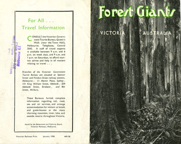 Marysville & District Historical Society
Ephemera (Item) - Information brochure, Victorian Government Tourist Bureau, Forest Giants Victoria Australia, 01-1938
An information brochure on where to see tall trees, Forest Giants, in Victoria, including Marysville, that was published in January, 1938.An information brochure on where to see tall trees, Forest Giants, in Victoria, including Marysville, that was published in January, 1938.Victorian Railways Print January, 1938 469-38 Stamp of Victorian/ Government Tourist Bureau/ 272 Collins Street/ Melbourne C.1victoria, australia, victorian government tourist bureau, betterment and publicity board, victorian railways, white mountain ash, red mountain ash, messmate, blue gum, mountain ash, cumberland valley, marysville, mount monda, healesville, acheron way, alpine highway, omeo, baw baws, strzelecki ranges, otway ranges, warburton, yarra junction, noojee, bulga and tarra valley park, yarram, turton's pass, otway forest, beech forest, apollo bay, information brochure, brochure -
 Marysville & District Historical Society
Article (item) - Newspaper article, The Alexandra and Eildon Standard, Indigenous history in the shire after colonisation, 08-03-2017
A newspaper article regarding indigenous history in the Murrindindi Shire after colonisation of the region.A newspaper article regarding indigenous history in the Murrindindi Shire after colonisation of the region.Wednesday, March 8, 2017alexandra, kulin, taungurung, goulburn, woi wurrung, yarra, acheron river, little river, dandenong ranges, land board, aboriginal guardian, william thomas, aboriginal station, lands minister, acheron station, mohican run, rubicon river, cathedral mountain, john green, mohican station, upper yarra, yarra tribe, woori yallock, hoddles creek, yarra river, badger creek, healesville, coranderrk, christmas bush, prostanthera lasianthos, black's spur -
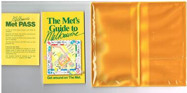 Melbourne Tram Museum
Book, The Met, "Met Pass", late 1980's
Yellow plastic folder titled "Melbourne Met Pass", with The Met logo in green print on both sides of the outside of the folder. On the inside has two pockets for storing items formed with clear plastic. Map Folded Map of Melbourne Rail and Tram lines, titled "The Met PASS Map to Melbourne" Tram Map - probably soon after conversion of the St Kilda and Port Melbourne lines to Light Rail, though these are not shown. Opened November 1987. Rail Map - shows Route 96 north section as Light Rail, co-ordinated bus routes, and the Altona line as going to Werribee. This route was opened in 1985. Date of Map c1988/1990. Has details of Museums, Art Galleries, Shopping, Gardens and Sports Arenas in Japanese. Sheet of paper advising users on presentation of the Met Pass (not included in the folder) Book - titled "The Met's Guide to Melbourne", sub titled - Get around on The Met. Card covers, perfect bound, 100 pages in colour with maps, guides and information about various locations within Greater Melbourne including Werribee Zoo and Healesville. See also Reg Item 106 to 108 for a similar item and 983 for the document that was used to launch the Met Pass. Two copies held.trams, tramways, the met, melbourne, tickets, tourist tickets -
 Eltham District Historical Society Inc
Folder, Pioneers & Painters; Shire of Eltham Historical Society notes, minutes, 1969-1971, 1969-1971
Material pertaining to the production of a history of the Shire of Eltham, "Pioneers & Painters: One Hundred Years of Eltham and its Shire" in recognition of the shire's centenary in 1971 Item Title Caption 04766-1 Background to publication of a Shire Centenary book from another shire, 7 February 1969 04766-2 Outcomes of Annual General Meeting held 11 February 1969, Shire of Eltham Historical Society, Advising office bearers for 1969 as well as notice for next meeting to be held 11 March 1969 at the Eltham War Memorial Hall where guest speaker Alan Marshall will talk on a proposal to compile a history of the Shire of Eltham to be published for the centenary of the Shire in 1971 04766-3 Letter: Russell Yeoman, Secretary, Shire of Eltham Historical Society to the Shire Secretary, Shire of Eltham seeking financial support for the publication of a history of the shire to celebrate its centenary in 1971, 21 February 1969 04766-4 Carbon copy Letter: Russell Yeoman, Secretary, Shire of Eltham Historical Society inviting Shire Councillors to next Historical Society meeting, 21 February 1969 Enclosed copy of letter sent to Shire Secretary, Shire of Eltham seeking financial support for the publication of a history of the shire to celebrate its centenary in 1971 04766-5 Notes following meeting with Alan Marshall regarding the publication of a history of the Shire of Eltham, 1969 In Russell Yeoman's hand writing 04766-6 Letter: M.B. Watson, Eltham Shire Secretary to Shire of Eltham Historical Society expressing support for the publication of a history of the Shire, 11 March 1969 04766-7 Alan Marshall's notes for talk to members of the Shire of Eltham Historical Society (March 1969) re research for Shire history publication, c.March 1969 04766-8 Minutes of the meeting of the Shire of Eltham Historical Society held 11 March 1969 04766-9 Letter: Russell Yeoman, Secretary, Shire of Eltham Historical Society to F. Endacott, President of Healesville Historical Society seeking information for the publication of a history of the shire to celebrate its centenary in 1971, 10 June 1969 Areas of Healesville were initially part of the Shire of Eltham 04766-10 Letter: Page 1 of letter from F. Endacott, President, Healesville Historical Society, to Russell Yeoman regarding the history of the Shire of Eltham extending beyond Healesville, 21 June 1969 04766-11 Notice to members of the Shire of Eltham Historical Society regarding publication of a history of the Shire to be edited by Alan Marshall and advising next meeting to be held 24 June 1969 04766-12 Letter: RHSV to Shire of Eltham Historical Society agreeing to place any source material at the disposal of the society for the upcoming publication on the history of the Shire of Eltham, 30 June 1969 04766-13 Letter: Russell Yeoman, Secretary , Shire of Eltham Historical Society to Melbourne & Metropolitan Board of Works seeking material for a history of the Shire. c.1969 Specific mention regarding the Maroondah Aqueduct 04766-14 Letter: Russell Yeoman, Secretary , Shire of Eltham Historical Society to Peter Cuffley of Hamilton seeking material for a history of the Shire. 8 July 1969 Specific mention regarding Sweeneys 04766-15 Letter: Rev. Donald Longfield to Russell Yeoman regarding potential sources of information and photographs for a history of the Shire of Eltham, 9 July 1969 04766-15-2 Letter: Rev. Donald Longfield to Russell Yeoman regarding potential sources of information and photographs for a history of the Shire of Eltham, 9 July 1969 04766-15-3 Letter: Rev. Donald Longfield to Russell Yeoman regarding potential sources of information and photographs for a history of the Shire of Eltham, 9 July 1969 04766-16 Letter: Russell Yeoman, Secretary , Shire of Eltham Historical Society to Royal Historical Society of Victoria seeking assistance on material for a history of the Shire. c.1969 Specific mention regarding the Maroondah Aqueduct 04766-17 Letter: Russell Yeoman, Secretary , Shire of Eltham Historical Society to the Editor, RHSV Newsletter on the Society seeking material for a history of the Shire. 24 July 1969 04766-18 Notice and Agenda for Shire of Eltham Historical Society Meeting to be held 26 August 1969 Peter Basset-Smith to show his films of Eltham & District in the 1930s 04766-19 Letter: L.J. Corben, Acting Assistant Secretary, Melbourne & Metropolitan Board of Works to Russell Yeoman, Secretary , Shire of Eltham Historical Society regarding availability of material on the Maroondah Aqueduct and Dam in support of a publication on the history of the Shire, 29 August 1969 Specific mention regarding the Maroondah Aqueduct 04766-20 Notice for Shire of Eltham Historical Society Meeting to be held 23 August 1969 Peter Basset-Smith to show his films of Eltham & District in the 1930s 04766-21 Notice of cancellation for Shire of Eltham Historical Society Meeting to be held October 1969 04766-22 Notice for Shire of Eltham Historical Society Meeting to be held 25 November 1969 04766-23 Notes regarding Shire of Yea's plans to publish a book on the shire's history for its centenary in 1969 04766-24 Draft notice for call-out of historical photographs and documents in support of a publication on the history of the Shire of Eltham, 1969 04766-25 Notes from meeting of Shire of Eltham Historical Society, History Publication Committee meeting, c.1969 04766-26 Note to Russell Yeoman advising sources of printed material, photographs, etc for Pioneers & Painters - A History of Eltham Shire, c.1969 04766-27 Letter: Russell Yeoman, Secretary , Shire of Eltham Historical Society to Heidelberg Historical Society seeking material for a history of the Shire. c.1969 Specific mention regarding floods in the area and the Heidelberg School of Painters 04766-28 Letter: Russell Yeoman, Secretary , Shire of Eltham Historical Society to Doncaster Historical Society seeking material for a history of the Shire. c.1969 Specific mention regarding Warrandyte and recent Fitzsimons Lane bridge 04766-29 Notice for Shire of Eltham Historical Society Meeting to be held 27 January 1970 04766-30 Notice for Shire of Eltham Historical Society Annual General Meeting to be held 24 February 1970 04766-31 Notice of Office Bearers elected at the Shire of Eltham Historical Society Annual General Meeting held 24 February 1970 and notice of next meeting to be held 24 March 1970 04766-32 Notice for Shire of Eltham Historical Society Meeting to be held 28 April 1970 04766-33 Notice from Russell Yeoman, Secretary, Shire of Eltham Historical Society to members advising on progress of the History Publication Committee, c. 1970 Also noted, the Society has a new P.O. Box address; P.O. Box 37 Eltham Vic. 3095 04766-34 Letter: Draft copy of letter from Russell Yeoman, Secretary, Shire of Eltham Historical Society expressing appreciation to Cr. Charis Pellis for chairing the committee which led to the publication of Pioneers & Painters, 23 August 1971 04766-35 Letter: Mrs Stella Graham of Diamond Creek to Secretary Shire of Eltham Historical Society, 1971; requesting the return of her personal papers lent in conjunction with the compilation of the history of the Shire of Eltham 04766-36 Letter: Mrs Stella Graham of Diamond Creek to Alan Marshall, 3 Aug. 1971; requesting the return of her personal papers lent in conjunction with the compilation of the history of the Shire of Eltham 04766-37 Letter: Margaret Orford of Nhill to Alan Marshall, 7 Feb 1970; advising she cannot help with any photos. Her Uncle who Alan Marshall had interviewed had all memorabilia however she definitely wanted to buy a book when available.The idea to develop a book on the history of the Shire of Eltham to be edited by noted author, Alan Marshall in celebration of the shire's centenary was initiated in 1969. The Shire of Eltham Historical Society undertook significant research in conjunction with Alan Marshall locating material at various institutions and other societies; interviewing longer term residents and a public campaign through the local press to acquire photographic material for duplication and use in the book. The public campaign received generous response and the material collected became the genesis for the Shire of Eltham Pioneers Photograph collection now held in partnership between Eltham District Historical Society and Yarra Plenty Regional Library (Eltham Library).Miscellaneous notes, copies of letters and minutes of the Shire of Eltham Historical Societyalan marshall, apted, arthurs creek, bridge street, burgoyne, cr. charis pelling, cracknell, dan glasgow, donald longfield, doncaster historical society, elsie reynolds, ethel williams, fitzsimons lane bridge, floods, frank berkery, heidelberg historical society, history publication committee, joslyn, kath stephenson, maroondah aqueduct, minutes, mmbw, motschall, panton hill, pioneers and painters, research (vic.), rev. jock ryan, rev. ken briarty, rev. longfield, rhsv, royal historical society of victoria, russell yeoman, shire of eltham historical society, shire of eltham, shire of eltham pioneers photograph collection, smith, stella graham, sweeney, yea shire council, margaret orford -
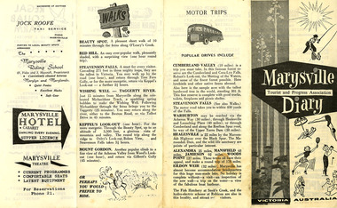 Marysville & District Historical Society
Ephemera (Item) - Programme of events, Marysville Tourist & Progress Association, Marysville Tourist and Progress Association Diary, 1963
A programme of events taking place in January, 1963, published by the Marysville Tourist and Progress Association. 1963 was Marysville's centenary year. The Association was formed in November 1907 to promote tourism within the area. This included the physical creation of signage, parklands, roads and walks to various attractions. A programme of events taking place in January, 1963, published by the Marysville Tourist and Progress Association. 1963 was Marysville's centenary year.marysville, victoria, programme, marysville tourist and progress association, misslynn beauty salon, marysville garage, crossways cabaret, l.h. potter, marysville swimming pool, regal squab farm, bartons stores, fruit salad farm, percy postlethwaite, jock roofe taxi service, the marysville riding school, marysville hotel, marysville theatre, cumberland valley, steavenson falls, warburton, healesville, alexandra, mansfield, jamieson, wood's point, eildon weir, snob's creek, rubicon, beauty spot walk, red hill walk, wishing well, taggerty river, keppel's lookout, mount gordon -
Ringwood and District Historical Society
Scrap Book, Scrap book of Mr. J.K. Turnbull, Ringwood's first Station Master, containing correspondence, newspaper clippings, obituaries and personal memorabilia c.1890-1913, c. 1890 - 1913
Mr J.K. Turnbulls own scrap book lent by his son to Mr McCaskill. Alan Carter got it from Mr McCaskill to return but the son died and Alan Carter gave it to the Historical Society. Mr Turnbull was Ringwood's first Station Master and a well liked person in the community.Mr J.K. Turnbulls own scrap book. Large blue cardboard covers with black and red embossing and 'Scraps' on front. Blue cloth spine. No pages held by spine - five with cuttings from papers pasted on to them; three handwritten letters; several single cuttings.; 1. Five pages of newspaper cuttings pasted to page.; 2. Post Office Telegraphs 14-Jan-1891; 3. Small ad. - Frank Lowe - is running a waggonette to meet every train - stables - 'Coach and Horses Hotel' 12-Jan-1913; 4. Mr Turnbull at Healesville; a favourite Returns; two cuttings with same story.; 5. Photocopy of the 'Programme of Dances for the Opening of the Ringwood Goods Shed' Monday 28 December 1887.; 6. Handwritten in pencil - New Goods Shed 28/11/1887. Opening ceremony 2-Dec-1887 - not very legible - 4 pages (15 x 10cm); 7. Two letters to Mr Turnbull from John Ross - 17-Jan-1891; 8. Letter from Samuel and Elizabeth Cutts and family to Mr Turnbull.; Note: Cutts, Elizabeth - owned the hotel at Burnt Bridge; Mr McCaskill was mayor and first President of the Historical Society; Carter, Alan - was father of Richard Carter. +Additional Keywords: Turnbull, J.K. / McCaskill, Mr / Carter, Alan / Lowe, Frank / Ross, John / Cutts, Samuel / Cutts, Elizabeth'Scraps'