Showing 716 items
matching land allotments
-
 Bendigo Historical Society Inc.
Document - H.A. & S.R. WILKINSON COLLECTION: CONDITION OF SALE
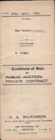
Conditions of sale by private contract dated 24th April 1930 between H.A. Wilkinson (seller) and R. Rigby (buyer) for land situate Vinton Street, California Gully being such parts as lie above the depth of fifty feet below the surface and being Crown allotment 589 section M borough of Eaglehawk described in Crown grant volume 3293 folio 658581, together with weatherboard dwelling and all sundry. Price 85 pounds.organization, business, h.a. & s.r wilkinson real estate -
 Bendigo Historical Society Inc.
Document - H.A. & S.R. WILKINSON COLLECTION: CONTRACT OF SALE
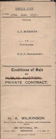
Conditions of sale by private contract dated 17th June, 1930 between A.G. McKenzie (seller) and E.G.S. Rasmussen (buyer) for land situate Havlin Street, Bendigo adjoining Mr. J. Bennett's property and occupied by Mr.. Price as tenant, being part of Crown allotments 392 and 393 section 8 described in certificate of title volume 5514 folio 1102695, together with 5-roomed weatherboard dwelling and all sundry. Price 775 poundsorganization, business, h.a. & s.r wilkinson real estate -
 Bendigo Historical Society Inc.
Document - H.A. & S.R. WILKINSON COLLECTION: CONDITION OF SALE
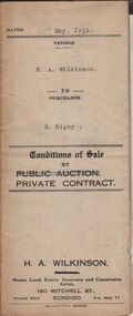
Conditions of sale by private contract dated 12th May, 1932 between H.A. Wilkinson (seller) and S. Rigby (buyer) for land within the special settlement area situate Junortoun containing 17 acres, 1 rood, 27 perches being allotment 37F Parish of Wellsford, County of Bendigo described in Crown grant volume 4485 folio 896958, together with 4-roomed weatherboard dwelling and all sundry. Price 575 pounds.organization, business, h.a. & s.r wilkinson real estate -
 Bendigo Historical Society Inc.
Document - H.A. & S.R. WILKINSON COLLECTION: CONTRACT OF SALE
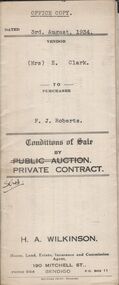
Conditions of sale by private contract dated 3rd August, 1934 between Mrs, E. Clark (seller) and F.J. Roberts (buyer) for land situate No. 7 Cobden Street, Bendigo at present occupied by Mrs. Fallon as tenant, being part of Crown allotment 7 and 8 section 65C described in certificate of title volume 4710 folio 941957, together with 6-roomed weatherboard dwelling and all sundry. Price 450 poundsorganization, business, h.a. & s.r wilkinson real estate -
 Bendigo Historical Society Inc.
Document - H.A. & S.R. WILKINSON COLLECTION: CONTRACT OF SALE
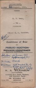
Conditions of sale by private contract dated 3rd August, 1950 between E.N. Dean (seller) and Miss E.A. Packham (buyer) for land situate No. 1 Dillon Street, Long Gully being Crown allotment 497 section K described in certificate of title volume 3999 folio 799707, together with 3-roomed weatherboard dwelling and all sundry. Price 1,650 pounds. Also attached letter dated 5th August, 1950 signed by Mr. Dean to Messrs. Williams, Watson & James solicitors advising them to pay Mr. H. Button of 28 Harrison Street, Bendigo the sum of 32 pounds from the proceeds of the sale of property.organization, business, h.a. & s.r wilkinson real estate -
 Bendigo Historical Society Inc.
Document - H.A. & S.R. WILKINSON COLLECTION: CONTRACT OF SALE
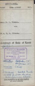
Contract of sale of land dated 15th August, 1951 between Mrs. E.R. Tieman (seller) and Mr. H.A. Pitson (buyer) for land being part of Crown allotment 6 section 71C described in certificate of title volume 4173 folio 834590 situate No. 47 Station Street, Bendigo, together with 4-roomed weatherboard dwelling and all sundry. Price 1,720 pounds.organization, business, h.a. & s.r wilkinson real estate -
 Bendigo Historical Society Inc.
Document - H.A. & S.R. WILKINSON COLLECTION; CONTRACT OF SALE
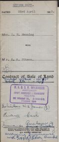
Contract of sale of land dated 23rd April, 1953 between Mrs. L.M. Manning (seller) and Mr. L.A. Pitson (buyer) for land situate 134 Bannister Street, Bendigo being north-east of and about 195 links from allotment 503 section K described in right to occupy residence area right No. 4612, together with 5-roomed weatherboard dwelling and all sundry. Price 1,350 pounds.organization, business, h.a. & s.r wilkinson real estate -
 Bendigo Historical Society Inc.
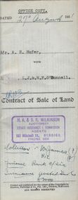
Document - H.A. & S.R. WILKINSON COLLECTION: CONDITION OF SALE
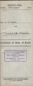
Contract of sale of land dated 27th August 1951 between Mr. A.H. Hufer (seller) and L.J. & W.E. O'Donnell (buyer) for land being part of Crown allotment 11 and 12 section 110C described in certificate of title volume 5322 folio 1064288 situate No. 131 Russell Street, Bendigo, together with 4-roomed weatherboard dwelling and all sundry. Price 2,750 pounds. Vendor's copy.organization, business, h.a. & s.r wilkinson real estate -
 Bendigo Historical Society Inc.
Document - H.A. & S.R. WILKINSON COLLECTION: CONDITION OF SALE
Contract of sale of land dated 27th August 1951 between Mr. A.H. Hufer (seller) and L.J. & W.E. O'Donnell (buyer) for land being part of Crown allotment 11 and 12 section 110C described in certificate of title volume 5322 folio 1064288 situate No. 131 Russell Street, Bendigo, together with 4-roomed weatherboard dwelling and all sundry. Price 2,750 pounds. Also attached handwritten note from Williams, Watson & James solicitors and receipts for 100 pounds deposit for sale.organization, business, h.a. & s.r wilkinson real estate -
 Bendigo Historical Society Inc.
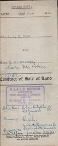
Document - H.A. & S.R. WILKINSON COLLECTION: CONDITION OF SALE
Contract of sale of land dated 23rd June, 1952 between Mr. J.L.C. Hunt (seller) and Miss D.A. Phillips for land being Lot 18 on plan of subdivision No. 14194, being part of Crown allotments 454A and 476 section H described in certificate of title volume 6110, folio 975 situate in Murray Street, Bendigo, together with 50roomed weatherboard dwelling and all sundry. Price 2,525 pounds.organization, business, h.a. & s.r wilkinson real estate -
 Bendigo Historical Society Inc.
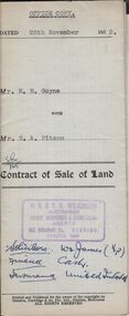
Document - H.A. & S.R. WILKINSON COLLECTION: CONDITION OF SALE
Contract of sale of land dated 28th November, 1952 between Mrs. M.M. Goyne (seller) and Mr. H.A. Pitson (buyer) for land situate No. 140 Lily Street, Bendigo being allotment 21 section 39B described in right to occupy residence area No. 4775, together with weatherboard dwelling and all sundry. Price 1,075 pounds.organization, business, h.a. & s.r wilkinson real estate -
 Bendigo Historical Society Inc.
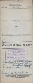
Document - H.A. & S.R. WILKINSON COLLECTION: CONDITION OF SALE
Contract of sale of land dated 17th April, 1953 between Mr. R.V. Cumming (seller) and Mrs.. M.I. Poole & Mrs. M.M. Moore (buyer) for land being part of Crown allotment 32 and 33 section H described in certificate of title volume 7697 folio 106 situate at 131A Sommerville Street Bendigo, together with weatherboard dwelling and all sundry. Price 5,050 pounds.organization, business, h.a. & s.r wilkinson real estate -
 Bendigo Historical Society Inc.
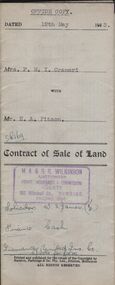
Document - H.A. & S.R. WILKINSON COLLECTION: CONDITION OF SALE
Contract of sale of land dated 12th May, 1953 between Mrs. F.M.T. Crameri (seller) and Mr. H.A. Pitson (buyer) for land being part of Crown allotment 2, section 125C described in certificate of title volume 6429, folio 692 situate No. 79 Garsed Street, Bendigo, together with a right of carriage way over the land coloured blue on the certificate of title with 5-roomed weatherboard dwelling and all sundry. Price 1,825 pounds.organization, business, h.a. & s.r wilkinson real estate -
 Bendigo Historical Society Inc.
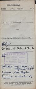
Document - H.A. & S.R. WILKINSON COLLECTION: CONDITION OF SALE
Contract of sale of land dated 10th August, 1953 between Mr. N.V. Wodetzki (seller) and Mr. D. & Mrs. E.M. Phillips for land being part of Crown allotment 7 section 31C described in certificate of title volume 6403, folio 473 situate at No. 158 Barkly Place, Bendigo, together with all registered appurtenant easements. Brick dwelling and all sundry. Price 1,950 pounds.organization, business, h.a. & s.r wilkinson real estate -
 Bendigo Historical Society Inc.
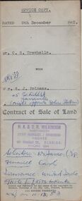
Document - H.A. & S.R. WILKINSON COLLECTION: CONDITION OF SALE
Contract of sale of land dated 9th December 1953 between Mr. C.S. Trewhella (seller) and Mr. S.J. Prineas (buyer) for land being part of Crown allotment 5 section 32 borough of Eaglehawk described in Certificate of title volume 7060 folio 912 and situate 1 Richards Street Eaglehawk, together with brick veneer dwelling and all sundry. Price 3,450 pounds.organization, business, h.a. & s.r wilkinson real estate -
 Bendigo Historical Society Inc.
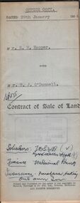
Document - H.A. & S.R. WILKINSON COLLECTION: CONDITION OF SALE
Contract of sale of land dated 29th January 1954 between Mr. E.M. Hopper (seller) and Mr. G.J. O'Donnell (buyer) for land being Lot 2 on plan of subdivision No. 23332 registered in the office of titles, Melbourne and situate in Lindsay Street Kangaroo Flat part of Crown allotment 11 section 23, township of Kangaroo Falt described in Certificate of title volume 7446 folio 423, together with weatherboard dwelling, wood shed-lavatory also fencing on the said land. Price 2,700 pounds.organization, business, h.a. & s.r wilkinson real estate -
 Bendigo Historical Society Inc.
Document - H.A. & S.R. WILKINSON COLLECTION: CONDITION OF SALE
Contract of sale of land dated 16th November, 1954 between Mr. W.A. Haywood (seller) and Mrs A.E. Pendlebury for land situate corner Brown and Green Streets, Long Gully being allotment 500A section K described in residence licence 0943 129, together with 2-roomed cement brick dwelling and all sundry, also electric copper and cement troughs, concrete mixer and concrete moulds. Price 450 pounds.organization, business, h.a. & s.r wilkinson real estate -
 Bendigo Historical Society Inc.
Document - H.A. & S.R. WILKINSON COLLECTION: CONDITION OF SALE
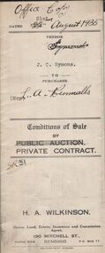
Conditions of sale by private contract dated 22nd August 1935 between J.C. Symons (seller) and Mrs L.A. Runnalls for land situate corner Goyne Road and Epsom Road, Epsom, being Crown allotment 4 and 8 section 25 containing approx. 3 acres, 2 rood and 9 perches and occupied by Mr. Makeham as tenant, together with 4-roomed weatherboard dwelling and all sundry. Price 340 pounds.organization, business, h.a. & s.r wilkinson real estate -
 Bendigo Historical Society Inc.
Document - H.A.& S.R. WILKINSON COLLECTION: CONDITION OF SALE
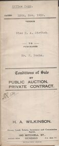
Conditions of sale by private contract dated 12th November 1935 between Miss E.A. Stritch (seller) and Mr. F. Roche (buyer) for land situate No. 81 King Street, Bendigo being part of Crown allotment 15A section 52C described in certificate of title volume 1604 folio 320693, together with 5-roomed weatherboard and brick dwelling and all sundry. Price 375 pounds.organization, business, h.a. & s.r wilkinson real estate -
 Bendigo Historical Society Inc.
Document - H.A. & S.R. WILKINSON COLLECTION: CONDITION OF SALE
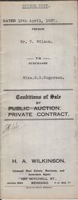
Conditions of sale by private contract dated 19th April, 1937 between Mr. T. Wilson (seller) and Miss E.E. Rogerson (buyer) for land situate 118 Violet Street, Bendigo, having a frontage of 100 links by a depth of 121.8 links on the South side and 132.4 links on the North side, being part of Crown allotment 14 section 12B described in Crown grant volume 2560 folio 515867, together with 5-roomed weatherboard dwelling and all sundry. Price 290 pounds.organization, business, h.a. & s.r wilkinson real estate -
 Bendigo Historical Society Inc.
Document - H.A. & S.R. WILKINSON COLLECTION: CONDITION OF SALE
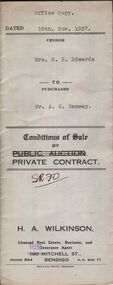
Conditions of sale by private contract dated 15th November 1937 between Mrs E.E. Edwards (seller) and Mr. A.E. Ramsay (buyer) for land situate corner Wattle and Langston Streets, Bendigo being Crown allotment 55 section K described in residence area right No. 044, together with 4-roomed weatherboard dwelling and all sundry. Price 225 pounds.organization, business, h.a. & s.r wilkinson real estate -
 Bendigo Historical Society Inc.
Document - H.A. & S.R. WILKINSON COLLECTION: CONDITION OF SALE
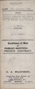
Conditions of sale by private contract dated 14th November, 1938 between Sandhurst and Northern District Trustees Executors and Agency Company Limited as Executor of will of Richard Lowe deceased (seller) and W. A. Rankin (buyer) for land situate No. 139 Olinda Street, Bendigo being part of Crown allotment 5 and 6 section 96C described in certificate of title volume 2367 folio 473243 and having 100 links to Olinda Street by a depth as fenced, together with 4-roomed weatherboard dwelling and all sundry. Price 800 pounds.organization, business, h.a. & s.r wilkinson real estate -
 Bendigo Historical Society Inc.
Document - H.A.& S.R. WILKINSON COLLECTION: CONDITION OF SALE
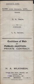
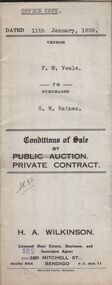
Conditions of sale by private contract dated 11th January, 1939 between F.W. Veale (seller) and G.W. Raines (buyer) for land situate No. 11 Alley Street, Bendigo being part of Crown allotment 70 section A at Ironbark Gully described in deed of conveyance, registered memorial 836 book 532, together with 4-roomed weatherboard dwelling and all sundry. Price 250 pounds - Vendor's copy.organization, business, h.a. & s.r wilkinson real estate -
 Bendigo Historical Society Inc.
Document - H.A. & S.R. WILKINSON COLLECTION: CONDITION OF SALE
Conditions of sale by private contract dated 11th January, 1939 between F.W. Veale (seller) and G.W. Raines (buyer) for land situate No. 11 Alley Street, Bendigo being part of Crown allotment 70 section A at Ironbark Gully described in deed of conveyance, registered memorial 836 book 532, together with 4-roomed weatherboard dwelling and all sundry. Price 250 poundsorganization, business, h.a. & s.r wilkinson real estate -
 Bendigo Historical Society Inc.
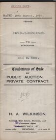
Document - H.A. & S.R. WILKINSON COLLECTION: CONDITION OF SALE
Conditions of sale by private contract dated 10th August, 1939 between Mrs L.T. McCullough (seller) and Mrs M. Rowe for the land situate Shamrock Street, Bendigo being part of Crown allotment 3, 6 and 7 section 33A land described in certificate of title volume 6198 folio 1239463. Price 190 pounds. Various receipt from Borough of Eaglehawk, Land department And water commission for rates, and other costs.organization, business, h.a. & s.r wilkinson real estate -
 Bendigo Historical Society Inc.
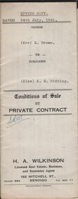
Document - H.A. & S.R. WILKINSON COLLECTION: CONDITION OF SALE
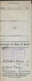
Conditions of sale by private contract dated 24th July, 1941 between Mrs. E. Brown (seller) and Miss A.G. Ridding (buyer) for land situate No.73 Honeysuckle Street, Bendigo being part of Crown allotment 6 section 14B described in Crown grant volume 1056 folio 211103, together with 4-roomed weatherboard and rough cast dwelling and all sundry. Price 615 pounds.organization, business, h.a. & s.r wilkinson real estate -
 Bendigo Historical Society Inc.
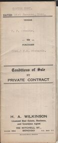
Document - H.A. & S.R. WILKINSON COLLECTION: CONDITION OF SALE
Conditions of sale by private contract dated 21st January, 1944 between T.F. Crombie (seller) and Mrs E.M. Richards (buyer) for land situate 101 Anderson Street, Bendigo being Crown allotment 538 section K described in Crown grant volume 2944 folio 538737, together with 5-roomed brick dwelling and all sundry. Price 450 pounds.organization, business, h.a. & s.r wilkinson real estate -
 Bendigo Historical Society Inc.
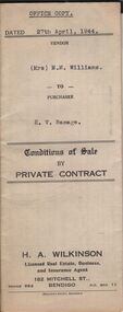
Document - H.A. & S.R. WILKINSON COLLECTION: CONDITION OF SALE
Conditions of sale by private sale dated 27th April 1944 between Mrs M.M. Williams (seller) and H.V. Ramage (buyer) for land situate Cohn Street near Holdsworth Road, Bendigo, being allotment 16 section K1, containing 2 acres, 1rood and 20 perches more or less in the City of Bendigo, described in Crown grant volume 6207 folio 1241225, together with 4-roomed weatherboard building, iron tank and all sundry. Price 33 pounds.organization, business, h.a. & s.r wilkinson real estate -
 Bendigo Historical Society Inc.
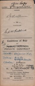
Document - H.A. & S.R. WILKINSON COLLECTION: CONDITION OF SALE
Conditions of sale by private contract dated 7th August, 1946 between A.J. Wilkinson (seller) and E.H.W. Reddick (buyer) for land situate in McKenzie Street West, Golden Square, being Crown allotments 6B and 6C section 44B described in certificate of title 4304 folio 860637. Price 150 poundsorganization, business, h.a. & s.r wilkinson real estate -
 Bendigo Historical Society Inc.
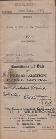
Document - H.A. & S.R. WILKINSON COLLECTION: CONDITION OF SALE
Conditions of sale by private contract dated 22nd July, 1947 between N.E. & Mrs. B. E. Woodall (sellers) and Mrs N.I. Rigby & Mrs D.M. Sayer (buyer) for land situate 86 Violet Street Bendigo, at present occupied by Mr. Bice as tenant, being the land in conveyance registered No. 66, book 589. Also the land untransferred in certificate of title volume 5350 folio 1071748 Crown allotment 19 section 11B, together with 5-roomed brick and weatherboard dwelling and all sundry. Price 600 pounds.organization, business, h.a. & s.r wilkinson real estate