Showing 10914 items
matching lander
-
 Bendigo Historical Society Inc.
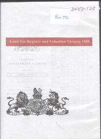
Archive - LAND TAX REGISTER, 1888
DVD. Land Tax Register and Valuation Victoria 1888. -
 Bendigo Historical Society Inc.
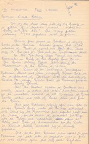
Document - BUSINESS LICENSE PETITION
Handwritten and typed copies of a Business License Petition. Petition is about storekeepers, etc. who have built their businesses on Crown Land. The petitioners hoped that the land upon which they have erected their premises may be surveyed and put up for public auction and that the premises on the land are valued and allowed for.document, names of bendigo pioneers, business license petition, business license petition, i hendry, major general macarthur -
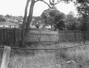 Ringwood and District Historical Society
Photograph, Edwin G. Adamson A.R.P.S, Maroondah Highway Central, Ringwood. Vacant land, rear of the oval, 1963. (Eastland Litigation Photo)
This series of SS0380 photos are part of the "Eastland Litigation" launched in 1962 by the Whitehorse Traders Co-operative Association (WTCA), against the Ringwood Council's Interim Development Order of 1960. WTCA sought "orders from the Supreme Court of Victoria that the planning scheme was invalid" - See "The Eastland Litigation" chapter in "From Horse Shoes to High Heels - Ringwood Shopping Centre and Eastland 1858-2008" by Richard Carter, Bounce Books 2009.Black and White PhotographWritten on back of photograph: "Photo of the vacant back land, rear of oval, i.e. - land in private occupation." Stamped on rear of photograph, 'Edwin G. Adamson...May 63'. -
 Kew Historical Society Inc
Photograph - Victorian Double-fronted Brock Villa, Cotham Road, c. 1919
The Kew Historical Society's map collection includes a substantial number of real estate subdivision plans, mainly of Kew but also of surrounding suburbs in Melbourne. Most of the subdivision plans date from the 1920s and 1930s when the districts old homes and local farmland were being split up to accommodate residential growth in the postwar period. These early plans were assembled by a local firm, Jas R Mather & McMillan, which had an office in Cotham Road. Many of the plans, and sometimes photos, were annotated by the agents.Subdivision plans are historically important documents used as evidence for the growth of suburbs in Australia. They frequently provide information about when the land was sold as well as evidence relating to surveyors and real estate and financial agents. The numerous subdivision plans in the Kew Historical Society's collection represent working documents, ranging from the initial sketches made in planning a subdivision to printed plans on which auctioneers or agents listed the prices for which individual lots were sold. In a number of cases, the reverse of a subdivision plan in the collection includes a photograph of a house that was also for sale by the agent. These photographs provide significant heritage information relating house design and decoration, fencing and household gardens.The photograph may also be aesthetically significant depending o the importance of the photographic atelier.Real estate photographs of a classic double-fronted late Victorian brick villa. It central location in Cotham Road, Kew enabled the selling agent to note its proximity to the tram. With seven rooms, all ‘modern conveniences’, and land of 66×167, the house was to be sold for £1100. The villa has a number of interesting features including a pattern within the slate roof as well as the use of polychrome brickwork under the eaves and on the façade. The intricacy of the cast iron lace is emphasised by the line of projecting wooden blocks above it. The picket gate is painted a different colour to the pickets of the fence. The house has a name (illegible) that is attached to the inset cast iron lace of the central projecting gable in the veranda. Stamped on mount: "Kew. Central. Close tram. / Comfortable Brick Villa. / Containing 7 rooms / Modern conveniences: / Land 66 x 167. Sold 1100 pounds:"houses - kew, victorian villas, real estate photographs, cotham road - kew -
 Kew Historical Society Inc
Journal - Visitor Book, Fairyland Book
"Fairyland", the home of Jim and Grace Tabulo, was a notable local, state and international tourist attraction situated in Kew, Victoria during the mid twentieth century. Located at 57 Malmsbury Street, Kew, the weatherboard house and its garden were heavily decorated with statues, crockery and other collected items. A series of notebooks were used to record the messages of child and adult visitors to the property from the 1940s to the 1960s. After Mrs Tabulo's death, these visitor books are believed to have formed part of the Dorothy Rogers Collection. They entered the Kew Historical Society's collection following Dorothy Roger's death in 1973.This series of visitor books are the most important primary sources relating to the internationally renowned 'Fairyland' cottage in Malmsbury Street, Kew. Their social significance is that they record in the post war period the values and beliefs of children and adults who visited this historically significant tourist attraction.Foolscap size visitor book containing handwritten comments and drawings primarily made by children during visits to the home of Grace Tabulo, c.1950-1960. Commonly known as "Fairyland", the house was located at 57 Malmsbury Street Kew. The book is wrapped in brown paper, which covers back cardboard covers with a red cloth strip binding. Unpaginated, approximately 160 pages, and covers. The book has an additional loosely inserted black card cover located at the front of the book.Handwritten in pencil on paper cover: "1950 - 1962 /(edit book dates)" Handwritten in ink on paper label on loosely inserted cover: "Fairy Land / Book/ September 1950 / Fairy Land / Book / 75 [sic] M...berry [indistinct] st Kew / Fairy Land Book"grace tabulo -- fairyland -- 57 malmsbury street -- kew (vic.), tourism - kew - 1945-1965, childhood - kew, collectors and collecting, gardens - kew (vic), scrapbooks - 20th century -
Whitehorse Historical Society Inc.
Article, People before profit - land sale opponent, 1992
A community group has criticised Nunawading Council's move to rezone and sell the Vermont South site it uses.A community group has criticised Nunawading Council's move to rezone and sell the Vermont South site it uses. The land is on the corner of Burwood Highway and Livingstone Road which is zoned D 'Public Open Space'. Council has deferred the decision to rezone until after a public meeting.A community group has criticised Nunawading Council's move to rezone and sell the Vermont South site it uses.town planning, city of nunawading, burwood highway, vermont south, livingstone road, vermont south, vermont south -
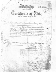 Whitehorse Historical Society Inc.
Document - Land Title, Certificate of Title, 28/10/1902
Certificate of Title for land between Ormond Avenue, Fellows Street, Victoria Avenue and Mitcham Road, Mitcham owned by Robert Becket. Transfers of land through subdivision are included.whitehorse road, mitcham, mitcham road, ormond avenue, victoria avenue, gillies street, deakin street, fellows street, haines street, purches street, albert street, edward street, britannia street, beckett, robert, johnson, catherine, bewley, william, londgerin, mary, chugg, william harold, wheeler, sarah, byrne, bedson, samuel, land subdivision -
 Mont De Lancey
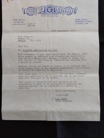
Document - Shire of Lillydale: Planning Application, Shire of Lillydale, 12th September, 1974
Vintage legal documents for land division in Victoria, especially those predating the Torrens system (October 1862), are often found in the Public Record Office Victoria (PROV). These documents, like deeds and Crown grants, can help trace the history of land ownership and division. A letter from K.H. Scott, Shire Engineer of the Shire of Lillydale Victoria to M. H. Proctor Re: Planning Application P.S./833. It is typed on the blue elaborately printed Shire letterhead and dated 12th September, 1974. The application from Mr Proctor to subdivide land situated and described as C.C. 12 Sec B Queens Road., Wandin was granted. Conditions apply.Signed 'Yours faithfully K H Scott K.H. Scott Shire Engineer' 'In reply please quote 1832:74 MGE:DW'legal documents, contracts, documents, indentures -
Whitehorse Historical Society Inc.
Article, Henry William Crouch, 11/12/1985 12:00:00 AM
Article in the Mirror by Joan Seppings Webster about Henry William Crouch.Article in the Mirror by Joan Seppings Webster about Henry William Crouch. Born in the U.K. and migrated to Australia aged 32. Married Sarah Lewis 6 years before leaving London. They lost their first 3 children and had 2 living sons. Henry, the eldest became a shire councillor. Henry William bought land in Church Road and started an orchard, prospered and later bought land in Williamson's Road on which 6 generations lived over 122 years. Sarah died and he married Harriet Tainton and they had 4 more children. Henry died by accident in 1913 aged 93.Article in the Mirror by Joan Seppings Webster about Henry William Crouch. crouch, henry william, lewis, sarah, crouch, henry, crouch, percival, church road, doncaster, williamson's road, doncaster, doncaster, doncaster church of christ, tainton, harriet lowan -
 Melbourne Tram Museum
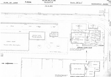
Drawing, Melbourne & Metropolitan Tramways Board (MMTB), "Glenhuntly Depot", c1937
Set of three photocopied plans or drawings on A3 sheet of "Glenhuntly Depot" - c 1938 .1 - P8334 - Plan of land showing details of offices and tennis court - 2-6-1938 .2 - P8335 - Plan of land showing car depot layout and associated buildings - 2-6-1938 - shows substation location. .3 - P8333 - Plan of land showing MMTB land and surrounding properties. - 2-6-1938trams, tramways, drawings, depots, property, glenhuntly tram depot, substation -
 Eltham District Historical Society Inc
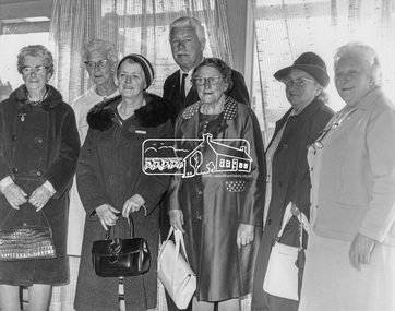
Photograph, His Excellency Major General Sir Rohan Delacombe with Lady members of the Shire of Eltham Elderly Citizens' Clubs, 19 September 1973
... lander ...The State Governor Sir Rohan Delacombe and Lady Delacombe visited the Shire of Eltham where they were entertained to a civic luncheon by the Shire President Cr. L. E. Clarke and councilors at the Panton Hill hotel and made a tour of the shire. Among which was the Eltham elderly citizens' club where he met L-R: Mrs Lander, Mrs Stevenson, Mrs Armstrong, Mrs Norman, Mrs - , and Mrs Crockett. This photo forms part of a collection of photographs gathered by the Shire of Eltham for their centenary project book,"Pioneers and Painters: 100 years of the Shire of Eltham" by Alan Marshall (1971). The collection of over 500 images is held in partnership between Eltham District Historical Society and Yarra Plenty Regional Library (Eltham Library) and is now formally known as 'The Shire of Eltham Pioneers Photograph Collection.' It is significant in being the first community sourced collection representing the places and people of the Shire's first one hundred years.Digital imagemajor general sir rohan delacombe, mrs armstrong, mrs crockett, mrs lander, mrs norman, mrs stevenson, sepp, shire of eltham pioneers photograph collection, rohan delacombe, governor, visit, crockett, lander, sepp, senior citizens centre, seniors, older people, older women, stevenson, armstrong, shire of eltham pioneers photograph collection -
 Bendigo Military Museum
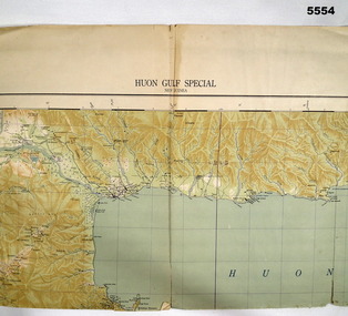
Map - MAP, HUON GULF AREA, Aust Survey Corps et al, Aug 43
Refer Cat 5547 - Matheson.This is a single sided map, printed in colour. Scale 1:253,440, 4 miles to an inch, grid squares are 10mm x 10mm. Top right side shows Finschafen. Top centre is Lae, Middle is Salamau. Bottom is Lasanga Island. Top left vicinity is Nadzab and Markham River.There are four "corner" marks in pencil. Two on land and two out in the gulf.ww2, new guinea, map -
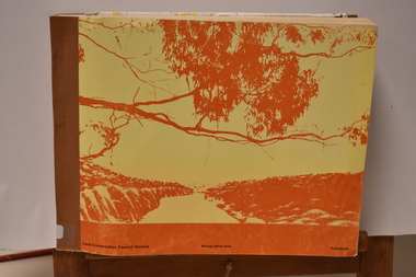 Tatura Irrigation & Wartime Camps Museum
Book - Land Conservation Council Victoria ( Murray Valley Area ), Land Conservation Council Victoria ( Murray Valley Area )
Report on public land use in the Murray Valley area in 1983Mediun size, Yellow and Orange Front Cover. Brown fabric Spine. White back. Heavy white envelope inside back cover that contains mapsnon-fictionReport on public land use in the Murray Valley area in 1983soils and land use -
 Kew Historical Society Inc
Photograph - 'Neama', Studley Park Road, 1978
Edward Augustus Atkyns was born in Wiltshire, England in 1840. His family emigrated to Australia in 1852. As a young man he was a keen cricketer and played at the first cricket ground in the district, located between Barkers Road and Hawthorn Grove, on the site of the future Barker railway station. Atkyns was admitted to the Victorian Bar in 1861, initially working in his father’s practice. He sat as a local magistrate in both Kew and Hawthorn and acted as solicitor for several shire councils. Elected to the Hawthorn Borough Council in 1863 at the age of 23, he served in that municipality as mayor in 1866-67. By 1877, he had moved to Kew where he lived at Neama in Studley Park Road, a property later incorporated into the St Paul’s School for the Blind.Rare colour photograph of what was once a significant house in Kew.Original colour positive photograph (Kodak print) of the secondary building at 'Neama', colloquially known as the 'hall'. Photographed by Stewart West in April 1978 (it was later demolished by the Villa Maria Society).Annotated reverse: "Timber hall on Fernhurst land / Transported there approx 1878."st paul's school for the blind, neama, studley park road -- kew (vic.), historic houses -- kew (vic.), villa maria society -
 National Wool Museum
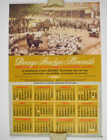
Dennys, Lascelles 1980 Calendar, 1980
The calendar was own by the donors father, John Arthur Ganly, who worked at Denny Lascelles most of his working life as an accountant. He started working at Denny's circa 1935 and stayed until he retired.Denny Lascelles 1980 calendar. The calendar has gold, white and red accents. Auction Sale in Sturt Street, Wagga Wagga, N.S.W., during the 1914-18 War is used as the header image.Dennys Strachan Mercantile Woolbrokers, Stock, Land and Insurance Agents 1980denny lascelles, denny lascelles wool warehouse -
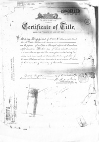 Whitehorse Historical Society Inc.
Certificate - Land Title document, Crown Allotment, 5/11/1909
Certificate of Title dated 5/11/1909 covering land in Shady Grove Nunawading purchased by Mary Higgins. Crown Land Allotment No. 116 Parish of Nunawading County of Bourke.land titles, higgins, mary, holmes, dave, shady grove nunawading no.76, helen -
Lakes Entrance Historical Society
Book, Land Conservation Council Victoria Gippsland Lakes Hinterland Area, 1982
Report describing the physical nature of the land in the Gippsland Lakes (Victoria) Hinterland Study area. History, climate, geomorphology, land use, flora and fauna are presented. 1 map in pocket.waterways, gippsland, natural history, vegetation -
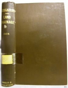 Flagstaff Hill Maritime Museum and Village
Book, Irrigation and Land Drainage
WARRNAMBOOL MECHANICS’ INSTITUTE Warrnambool's Mechanics' Institute (or Institution as it was sometimes called) was one of the earliest in Victoria. On 17th October 1853 a meeting was held where it was resolved to request the Lieutenant Governor of the Colony to grant land for the erection of a Mechanics' Institutes building. A committee was formed at the meeting and Richard Osburne chaired the first meeting of this committee. The land on the North West corner of Banyan and Merri Streets was granted but there were no funds to erect the building. The Formal Rights of the Warrnambool Mechanics' Institute's encompassed its aims and these were officially adopted in1859; "This Institution has for its object the diffusion of literary, scientific, and other useful knowledge amongst its members, excluding all controversial subjects, religious or political. These objects are sought to be obtained by means of a circulating library, a reading room, the establishment of classes, debates, and the occasional delivery of lectures on natural and experimental philosophy, mechanics, astronomy, chemistry, natural history, literature, and the useful and ornamental arts, particularly those which have a more immediate reference to the colony." The Warrnambool Mechanics' Institute opened its first reading room in November1884 in the National School building at the corner of Banyan and Timor Streets. The Institute was funded by member subscription, payable on a quarterly, half yearly or yearly basis. Samuel Hannaford, the Manager of the Warrnambool Bank of Australasia, was the first Honorary Secretary of the Mechanics' Institutes, and an early President and Vice-President. He also gave several of the early lectures in the Reading Room. Another early Secretary, Librarian and lecturer was Marmaduke Fisher, the teacher at the National School. Lecture topics included The Poets and Poetry of Ireland', 'The Birth and Development of the Earth', 'The Vertebrae - with Remarks on the pleasures resulting from the study of Natural History' and 'Architecture'. In 1856 the Reading Room was moved to James Hider's shop in Timor Street, and by 1864 it was located in the bookshop of Davies and Read. In the 1860's the Mechanics' Institute struggled as membership waned but in 1866, after a series of fund raising efforts, the committee was able to purchase land in Liebig Street, on a site then called Market Square, between the weighbridge and the fire station. A Mechanics' Institute building was opened at this site in August 1871. The following year four more rooms were added to the main Reading Room and in 1873 the Artisan School of Design was incorporated into the Institute. The same year Joseph Archibald established a Museum; however it deteriorated when he was transferred to Bendigo in 1877. In 1880, with Archibald's return to Warrnambool, the Museum was re-established, and in 1885 a new building was built at the back of the Institute to accommodate the re-created School of Design, the Art Gallery and the Museum. In 1887 the Museum section was moved to the former court house in Timor Street (for some time the walls of the building formed part of the TAFE cafeteria but all is now demolished)). In 1911 the Museum was transferred back to the original building and the management of the Mechanics' Institute was handed over to the Warrnambool City Council. The Museum and Art Gallery became one and housed many fine works of art, and the Library continued to grow. The building was well patronised, with records showing that at the beginning of the 20th century there were between 500 and 800 visitors. During World War One the monthly figures were in the thousands, with 3,400 people visiting in January 1915. The Museum was a much loved Institution in Warrnambool until the contents of the Museum and Art Gallery were removed to make room for the Warrnambool City Council Engineers' Department. The contents were stored but many of the items were scattered or lost. When the original building was demolished the site became occupied by the Civic Centre, which included the new City Library. (The library was temporarily located in the old Palais building in Koroit Street.) In the process of reorganisation the Collection was distributed amongst the community groups: -The new City Library took some of the historic books and some important documents, historic photographs and newspapers. -The Art Gallery kept the 19th Century art collection and some of the artefacts from the museum. -The Historic Society has some items -The State Museum has some items -Some items were destroyed -Flagstaff Hill Maritime Village has old newspapers, Government Gazettes, most of the Mechanics' Institute Library, ledgers and documents connected to the Mechanics' Institute Library, some framed and unframed art works and some photographs. The Warrnambool Mechanics' Institute Library book collection is deemed to be of great importance because it is one of the few collections in an almost intact state, and many of the books are now very rare and of great value. Irrigation and Land Drainage with surface and subterranean waters Author: W Gibbons Cox Publisher: Angus & Robertson Date: 1906Label on spine cover with typed text RA 631.7 COX Pastedown front endpaper has sticker from Warrnambool Mechanics Institute and Free Librarywarrnambool, shipwrecked-coast, flagstaff-hill, flagstaff-hill-maritime-museum, maritime-museum, shipwreck-coast, flagstaff-hill-maritime-village, shipwrecked-artefact, great ocean road, book, warrnambool library, warrnambool mechanics’ institute, mechanics’ institute library, victorian library board, warrnambool books and records, warrnambool children’s library, warrnambool public library, w gibbons cox, irrigation and land drainage -
![Map, [Coornmill land area available for leasing for grazing, Parish of Coornmill]. Circa 1904](/media/collectors/5e461d8021ea67224c82f2a1/items/677cde147f2053f3e5d277c3/item-media/677cdeea7f2053f3e5d27bb4/item-fit-380x285.jpg) Bacchus Marsh & District Historical Society
Bacchus Marsh & District Historical SocietyMap, [Coornmill land area available for leasing for grazing, Parish of Coornmill]. Circa 1904
This map shows an area of land north of Bacchus Marsh in the Larderderg State Park area known as the Parish of Coornmill.The map indicates an area of land which was to be made available by public tender for grazing leaseholders. The plan to do this was discussed in the Bacchus Marsh Express newspaper on the 16 July, 1904, page 2, column 7. The area reserved for grazing leases is identified by red lines on the map. The Express described the area available for grazing was 12,000 acres.A single page paper map showing an area of land in the Parish of Corrnmill to be made available for grazing leases. A photo lithographed Lands Department Map. No scale indicated. The map is pasted into a bound volume containing 76 maps or plans in total. High resolution digital image stored on BMDHS computer network. coornmill parish maps, lerderderg state park maps, agriculture bacchus marsh area -
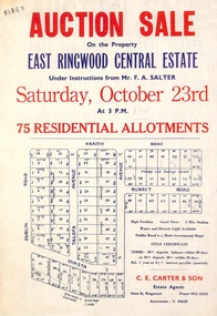 Ringwood and District Historical Society
Flyer, Land Auction Sale Advertisement, East Ringwood Central Estate - 1948
See Victorian Collections reference 5125 for subsequent Central Estate East Ringwood subdivision flyer.Single sided land auction sale advertisement for residential allotments.Auction Sale on the property under instructions from Mr. F.A. Salter. Subdivision includes Dublin Road, Knaith Road, Talofa Avenue, Russet Road, and Shasta Avenue. Agent - C.E. Carter & Son, Main Street, Ringwood. WU 6024. -
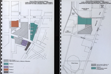 Federation University Historical Collection
Document, Documents relating to land aquisition for School of Mines and Industries Ballarat
School of Mines and Industries Ballarat is a predecessor of Federation University Diagrams relating to land aquisition for School of Mines and Industries Ballarat.school of mines and industries ballarat, land aquisition, car parking -
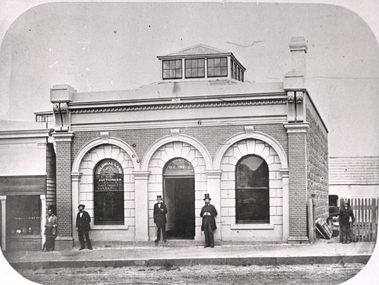 Federation University Historical Collection
Photograph - Black and White Photograph, William Collard Smith's Colonial Land Office
Photograph of illiam Collard Smith's Colonial Land Office in Ballaratwilliam collard smith, colonial land, auctioneer, bluestone, ballarat -
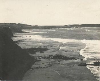 Phillip Island and District Historical Society Inc.
Photograph
Part of a collection donated by Miss Edith Elms via Chrisy NorthcoteCliffs on left with land surrounding Westernport Bay at low tidelocal history, photography, photographs, seascapes, san remo, black & white photograph, westernport -
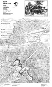 Greensborough Historical Society
Map, Dennis Ward, John Batman's 1835 Treaty Trail on the Plenty River, 2010_
Map of the Plenty River through Greensborough and surrounding areas, annotated with historic places. Prepared by Dennis Ward, this map shows places of interest with historic markers for a proposed Heritage Trail along the Plenty. This was a joint project of Dennis Ward, Rotary Greensborough and Nillumbik Historical Society.This map shows many places of interest along the Plenty River. Large laminated map, including land subdivisions and street names.plenty river heritage trail -
Eltham District Historical Society Inc
Folder, Adams, William, 1851
Folder of information on William Adams, land purchaser, Eltham 1851william adams -
Eltham District Historical Society Inc
Folder, James Graham, 1840
Folder of information on James Graham, Land Purchaser, Montmorency, 1840graham james, stuart donaldson -
 Running Rabbits Military Museum operated by the Upwey Belgrave RSL Sub Branch
Map France
Map of France showing position of front line and Nomans Landmaps, ww1, general -
Port Melbourne Historical & Preservation Society
Plan - Land sub-division at 34 Crockford Street, MMBW, Melbourne and Metropolitan Board of Works, Apr 1958
MMBW plan to sub-divide land at 34 Crockford St.built environment - commercial, percival edward mann, sue pentland, mmbw, melbourne and metropolitan board of works -
Port Melbourne Historical & Preservation Society
Book - Borough of Sandridge, accounts book, 1865
Accounts book for blocks of land rates, 1865. Borough of Sandridgelocal government - borough of sandridge -
Port Melbourne Historical & Preservation Society
Photograph - Sketch, Excavation of the Coode Canal and Reclaiming Land, 1880
Photograph of Sketch - Excavation of the Coode Canal And Reclaiming Land. 1880engineering - canals and drainage