Showing 1318 items matching "layout"
-
 Ringwood and District Historical Society
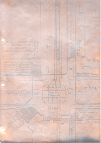
Flyer, Subdivisional Land Auction Sale Brochure, Grand Central Estate, Ringwood, Vic. - 1925
Douglas Street shown in the estate plan did not eventuate, but was developed as a public reserve. Refer also to Reg. No. 5149 for 1924 auction sale of land also titled Grand View Estate situated further north in Ringwood.Double sided multi-folded page advertising public auction sale on Saturday, 31st October, 1925, of residential allotments highlighting local facilities, services and layout of the estate. Includes panoramic view of Ringwood and other local photographic images.Subdivision includes Great Ryrie Street, Heathmont Road, Douglas Street, Garden Street, and Bellevue Avenue. Agents - Knight & Harwood, 315 Collins Street, Melbourne, Phone 10615, 10616 Central, in conjunction with J.B. McAlpin, Opposite Railway Station, Ringwood. Phone Ringwood 7. -
 Ringwood and District Historical Society
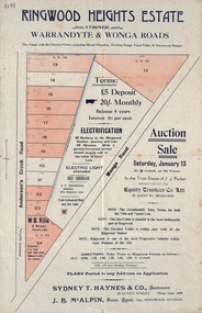
Flyer, Land Auction Sale Advertisement - Ringwood Heights Estate, Ringwood, Victoria - circa 1923
Advertisement for land and weatherboard villa auction sale on Saturday, January 13 (1923?) - Ringwood Heights Estate, corner Warrandyte and Wonga Roads, North Ringwood, with terms of sale, summary of local features and services, and map showing layout of subdivisionSubdivision includes Wonga Road and Anderson's Creek Road (later Warrandyte Road). Agents - Sydney T. Haynes & Co., Auctioneers, 60 Queen Street, Melbourne. Phone Central 3400; J.B. McAlpin, Estate Agent, Opposite Ringwood Station. Auction in the Trust Estate of J.J. Parker, instructed by the Equity Trustees Co. Ltd. 85 Queen Street, Melbourne. -
 Ballarat Tramway Museum
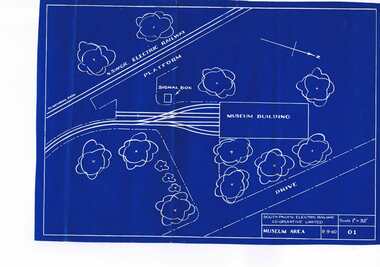
Plan, South Pacific Electric Railway, SPER Museum Area, 9/09/1960 12:00:00 AM
A blueprint of drawing 01 of the South Pacific Electric Railway showing 1960 proposal for the layout of the SPER Museum area, scale 1" = 32'. Drawing No. 01, Shows NSWGR railway. Scan added and entry updated 19-8-13trams, tramways, sper, loftus, museum plan -
![Photograph, Cr. D.S.M. Norris, Mayor [of Kew] 1943-4, ca. 1944](/media/collectors/550653872162f11fb04854aa/items/5922be3fd0cde6131c21aeb4/item-media/5c1b74ed21ea6818c05cd6a7/item-fit-380x285.jpg) Kew Historical Society Inc
Kew Historical Society IncPhotograph, Cr. D.S.M. Norris, Mayor [of Kew] 1943-4, ca. 1944
Kew achieved independence from the Boroondara Roads Board in 1860. As a new municipality, its first three leaders were designated as chairmen. On becoming a borough in 1863, its leaders were identified as mayors. The earliest photographs date from ca.1906, when the Town of Kew commissioned the noted local photographer Josiah E Barnes to produce standardised portraits of former mayors to be displayed in the Mayoral Chamber of the Town Hall. The collection also includes photographs by other well-known photographic studios such as Burlington Studios, Melba – Melbourne, Stuart Tompkins, Spencer Shier and Talma & Co. The majority of mounts identify the photographer. Eighty photographs are housed in their original frames.This portrait is one of a series of mounted and framed photographic portraits of mayors and town clerks of the former Borough, Town and City of Kew. The portraits were transferred by the City of Kew to the Kew Historical Society in March 1989. A Significance Assessment in 2018, funded by the National Library of Australia confirmed the historic, and often artistic significance of the series.Framed portrait of a mayor of Kew. The mounting and framing of the photograph follows a typical layout or style in that each is framed in dark wood, glazed, and laid down on an inscribed board. The inscription identifies the name of the mayor and the year/s that he/she served.mayors of kew (vic), australian photographers - c stuart tompkins, cr. d. s. m. norris, kew (vic.) — municipal collection -
 Lakes Entrance Historical Society
Photograph - Whiter's Camp Park, Bulmer H D, 1935
Black and white aerial view of Whiters Camp Park, looking north from Roadknight Street, showing layout of park including tennis courts, bowling green, picnic area, cottages, rotunda, and the family residence. Lakes Entrance Victoria tourism, camping -
 University of Melbourne, Burnley Campus Archives
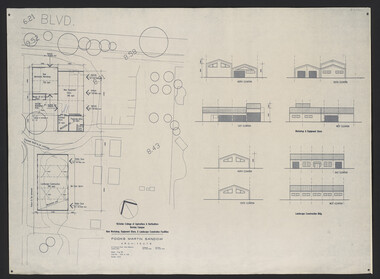
Plan, Fooks Martin Sandow Pty. Ltd, Victorian College of Agriculture & Horticulture Burnley Campus New Workshop, Equipment Store, & Landscape Construction Facilities, 1996
Plans by Fooks Martin Sandow, August 1996. Scale 1:200. (1) New Mechanics Workshop, New Equipment Store, etc. and Landscape Construction, with Elevations. (2) Layout of Equipment Store - where each piece of equipment to be placed.vcah, fooks martin sandow, equipment store, landscape construction -
 Melbourne Tram Museum
Document - Digital Image, Melbourne & Metropolitan Tramways Board (MMTB), MMTB Work Order Notes, c1927 to c1947
Provides information on tramway construction or reconstruction work undertaken by the MMTB from about 1927 to c1947. Organised with an overall index and then index for each letter. Place names may be different to what we used today. Details the location, work carried out, costs, other departments such as electrical overhead, stores, date. Some have a small diagram of the track work at the work site.Demonstrates the method that the MMTB recorded its track reconstruction work and costs.Digital image of a set of record cards scanned from ruled cards that had been stamped onto the card with a large rubber stamp, in red ink to give a generic layout. The rear of some cards have been used for notes.tramways, trackwork, costs, mmtb, new tramways, work orders, road works -
 Melbourne Tram Museum
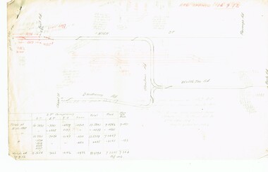
Drawing - Swanston St underground tramway at Flinders St, Melbourne & Metropolitan Tramways Board (MMTB), mid 1960s
Drawing shows the proposed layout of the Swanston St underground tram line at Flinders St. Shows the tram stop, the layout of the access to the stop, Flinders St and Princes Bridge stations, the demolition of Young and Jacksons Hotel, a railway booking office. This was part of a project that was for undergrounding of a number of tram lines in Melbourne during the early to mid 1960s. Yields information about the proposed undergrounding of the Swanston St tram line at Flinders St.Foolscap photocopied sheet on heat sensitive paper with four punched holes on the side.tramways, underground tramways, swanston st, proposed works, flinders st station -
 Ringwood and District Historical Society
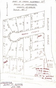
Map, Subdivision Plan - Adam Court area, North Ringwood, Vic. - circa 1960s
Single page plan printed showing allotments included in un-named subdivision layout surrounding Adam Court, Ringwood North. Subdivision includes Adam Court, Burlock Avenue, and Felix Crescent. Sold allotmenets marked in red, with price notations.Page heading - Part of Crown Allotment 27B Parish of Warrandyte County of Evelyn Scale 60'-1". Rubber stamp imprint and handwritten address at bottom of page - "Binburra Estates Pty. Ltd. 23 Pitt St., Ringwood, 870-1184". -
 Ringwood and District Historical Society
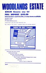
Flyer, Land Sale Advertisement - Woodlands Estate, North Ringwood, Victoria - circa 1970
Double sided single-page advertisement for land sale with locality map and layout of Woodlands Estate subdivision in North Ringwood, with summary of local features and services. No indication of date of flyer other than post-Eastland Shopping Centre opening in 1967.Subdivision includes Oban Road, Terrigal Close, Dorelaw Drive (later Melview Drive), Naroo Court, and Barook Court. Agent's rubber stamp imprint - H.C. Walton & Son, 264 Doncaster Road, North Balwyn. -
 Ballarat Tramway Museum
Photograph - Black & White Photograph/s, Charles Craig, mid 1950's
Photograph of the intersection of No. 17 with the destination of Beach in Pakington St at the junction with Aphrasia St. Shows the nature of the layout of the junction and has signs indicating a tram stop and "End of Section". Two large prints held - and one small one, with a vertical frame. trams, tramways, geelong, signs, aphrasia st, pakington st, tram 17 -
 Melbourne Tram Museum
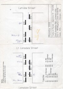
Drawing, Megafun, "Trams on Parade - Swanston St - 13/3/00 - Draft Assembly Map - Schematic Only", 2000
A4 sheet drawing - titled "Trams on Parade - Swanston St - 13/3/00 - Draft Assembly Map - Schematic Only" showing the proposed layout for trams between Lonsdale and Latrobe Street - prepared 2/2/00 by MM (Megafun)trams, tramways, moomba, swanston st, events, parades -
 Robin Boyd Foundation
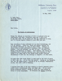
Letter, Peter Ryan, Peter Ryan to Robin Boyd, 14.05.1963
This letter discusses royalties, size, layout, and typography for Melbourne University Press's publication of Boyd's 'The Puzzle of Architecture'.Blue paper, typewritten -
 Ballarat Tramway Museum
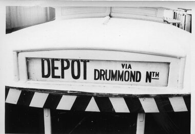
Photograph, Destination "Depot via Drummond Nth"
Close up of a single trucker - Destination sign "Depot via Drummond Nth", shows the layout of the sign.Demonstrates the layout of a Ballarat tramcar destination.Black and white photograph printOn rear in ink "Ballarat"trams, tramways, ballarat, destinations, depot, drummond st nth -
 Buninyong Visitor Information Centre
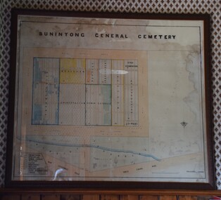
Plan - Cemetery Plan, Buninyong General Cemetery
Plan of the complete layout of the Buninyong General Cemetery drawn by Robert [surname unclear] on 6 April 1871.Framed and glazed original large hand drawn plan of the Buninyong General Cemetery, showing the locations of denominational sections and plots. Buninyong General Cemeterycemeteries, historic sites, buninyong -
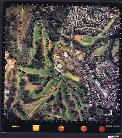
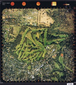 Heidelberg Golf Club
Photograph - Aerial Photograph, Heidelberg Golf Course 2000, 01/05/1980
Aerial photograph of Heidelberg Golf Club course in 1980, showing the course layout and surrounding land use.Aerial photograph, colour.Printed on edge of photo: "Colour proof", "LandSur756"aerial photographs, heidelberg golf club, lower plenty -
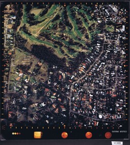 Heidelberg Golf Club
Photograph - Aerial Photograph, Heidelberg Golf Course 2000, 01/05/1980
Aerial photograph of Heidelberg Golf Club course in 1980, showing layout of course and surrounding land use.Aerial photograph, colour.Printed on edge of photo: "Colour proof", "LandSur756"aerial photographs, heidelberg golf club, lower plenty -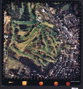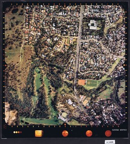
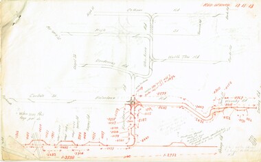
 Ballarat Tramway Museum
Document - Photocopy, Alan Bradley, "Car Depot / Wendouree Pde.", 2000
Set of four A3 size photocopies of a drawing VB4/8709c held by the Public Records Office Victoria of the Ballarat SEC Tramway Depot, dated 5/11/1971, Revision C 22/11/1971. Drawn at a scale of 1" = 20', shows building layout, track layout, overall dimensions, tree locations, pit details, rooms, paint shop, reduced levels, streets, toilets, steps to pits, tennis court and datum point. Drawn after the closure of the tramways, possibly to enable planning for the redevelopment and sale of the property. Drawings copied by Alan Bradley for archives and research.trams, tramways, ballarat, sec, depot, drawings -
 Melbourne Tram Museum
Document - Research Notes, H. S. McComb, "Coburg System" - part 1 of 2, c1956
Set of papers, handwritten concerning the development and timing of the "Coburg Tramway system" - about 34 sheets by the Melbourne Brunswick Coburg Tramways Trust. Prepared largely by H. S. McComb, with notes dates, depot, track layout, lengths, the Act, dates and calculations, curves, details of depot, track layouts, intersections and the interface with the cable tram at Queensberry and Swanston Streets. See Reg Item 2035 for part 2, further maps and details of the cable tram interface at Queensberry St. Items 2034 and 2034 within box 72.3 in a brown folder marked "MB&CTT" in red pencil.trams, tramways, mbctt, coburg, brunswick, opening, cable trams, queensberry, madeline st, moreland rd, sydney rd -
 Melbourne Tram Museum
Document - Research Notes, H. S. McComb, development and timing of the "PMTT" part 3, 1950's
Set of papers, handwritten concerning the development and timing of the "PMTT", Prahran and Malvern - about 30 sheets. Prepared by H. S. McComb - gives layout of the PMTT system, of track layout, opening dates, sketches of various junctions, bridges, track miles, junctions: Kew Junction, Glen Huntly Road, Glenhuntly Road, Victoria St cable tram terminus, Barkers Road, Commercial Road, Malvern Road, Hawthorn Road, Balaclava Junction, Caulfield station loop, Glenferrie Road. Items 2041 to 2052 within box 72.3 in a brown folder marked "PMTT" in red pencil.trams, tramways, pmtt, malvern, routes, track, kew junction, victoria st, barkers rd, glenhuntly rd, malvern rd, caulfield, hawthorn rd, balaclava rd, balaclava junction, glenferrie rd -
 Melbourne Tram Museum
Document - Research Notes, H. S. McComb, development and timing of the "PMTT" - part 4, 1950's
Set of papers, handwritten concerning the development and timing of the "PMTT", Prahran and Malvern - about 40 sheets. Prepared by H. S. McComb - gives layout of the PMTT system, primarily of Burke Road, sketches of track layout, opening dates, sketches of various junctions, bridges, track miles, junctions, reconciliation of track lengths from various sources includes Glenferrie and Cotham Road, Balaclava Road, Hawthorn Road, Glenhuntly Road, Waverley Road and St Kilda Esplanade, Candy Corner. Items 2041 to 2052 within box 72.3 in a brown folder marked "PMTT" in red pencil.trams, tramways, pmtt, malvern, routes, track, surveys, glenferrie rd, cotham rd, balaclava rd, hawthorn rd, waverley rd, st kilda, candy corner -
 Melbourne Tram Museum
Document - Research Notes, H. S. McComb, development and timing of the "PMTT" - part 5, 1950's
Set of papers, handwritten concerning the development and timing of the "PMTT", Prahran and Malvern - about 20 sheets. Prepared by H. S. McComb - gives layout of the PMTT system, primarily of Burke Road, sketches of track layout, opening dates, sketches of various junctions, bridges, track miles, junctions, reconciliation of track lengths from various sources includes High St Malvern, extension to Punt Road, Dandenong Road, Wattle Tree Road, including its duplication Items 2041 to 2052 within box 72.3 in a brown folder marked "PMTT" in red pencil.trams, tramways, pmtt, malvern, routes, track, surveys, wattle tree rd, punt rd, dandenong rd, high st, duplications -
 Robin Boyd Foundation
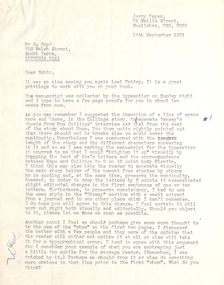
Letter, Jerry Mayer, Jerry Mayer to Robin Boyd, 14.09.1971
Jerry Mayer, Editor of "The Great, Great, Australian Dream", provides editorial content and layout changes, suggestions, and questions.Typewritten, quarto, 2 pages.Doodles -
 Federation University Historical Collection
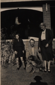
Photographs - black and white, Chatham-Holmes Collection: New home and gardens at "Launchley"
Eight black and white photographs showing the new built house at "Launchley" for Harry Holmes and the garden preparation and layout.A number of photos of the Holmes family at "Launchley", Ascot, Victoria. .1) Elizabeth Holmes, Harry Holmes and wife Edith in front of house at "Launchley". Ascot.chatham-holmes collection, harry holmes, launchley, gardens, edith holmes, elizabeth holmes -
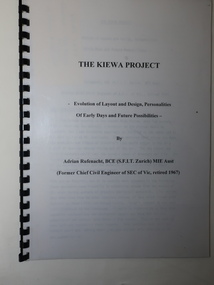 Kiewa Valley Historical Society
Booklet - The Kiewa Project, The Kiewa Project by Adrian Rufenacht
The Kiewa Hydro Electric Scheme was constructed by the SECVBooklet of 40 pages typed on both sides and including 4 maps at the back. It has a black plastic spiral spine and black back cover. Title on the front followed by 'Evolution of Layout and Design, Personalities / Of Early Days and Future Possibilities' followed by the authorkiewa hydro electric scheme, adrian rufenacht -
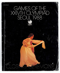 National Wool Museum
Booklet - Games of the XXIVTH Olympiad, Seoul 1988, Closing Ceremony, c. 1988
Program of the Closing Ceremony of the 1988 Seoul Olympics collected by Doug Pleasance. Cover colour is black to represent the close of the Olympics and correspond with the concept of 'Yang' , contrasting the Opening Ceremony book which was coloured white to represent 'Ying'.The Program is an oversized booklet containing the information of the layout and running of the Games of the Olympiad Seoul 1988 Closing Ceremony. The cover of the program is black to represent the close of the Olympics and corresponds with the concept of 'Yang' , contrasting the Opening Ceremony book which was coloured white to represent 'Ying'. 1988 seoul olympic games, closing ceremony, seoul, book, programme, ying, yang -
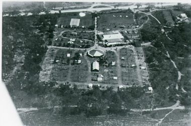 Lakes Entrance Historical Society
Photograph - Whiter's Camp Park, Bulmer H D, 1935
Black and white aerial view of Whiters Camp Park, looking south to Roadknight Street. Shows layout of camping facilities, including sites, tennis courts, rotunda, and family home which incorporated shop with all requirements for a holiday. Lakes Entrance Victoriatourism, resort, aerial photograph, camping