Showing 46224 items matching "main-hall"
-
 Rutherglen Historical Society
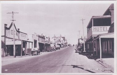
Image, c1940-1950
At the centre of the photo, on the left hand side of the road, is the Star Hotel. On the right hand side of the road, in the foreground is the Cumberland Hotel. Further along on the right of the road is the Rutherglen Hotel (now Poachers Paradise Hotel).One of three black and white photographs mounted on orange paper. This one of Main Street looking west.Printed at the bottom of the photo: "V5 Main Street, Rutherglen" Written on mount: "Main St. Looking east from western end. Circa late 40's early 50's"main street, star hotel, rutherglen hotel, poachers paradise hotel, hotels, shops, cumberland hotel -
 Clunes Museum
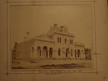
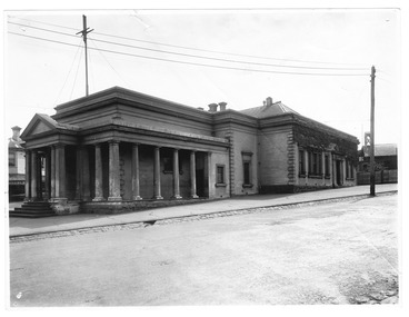
Photograph, J MEEK, TOWN HALL
TOWN HALL AND COURT HOUSE IN BAILEY STREET, CLUNES PHOTOGRAPH OF CLUNES TOWN HALL AND COURT HOUSE .1 SEPIA PHOTOGRAPH .2 COPY OF PHOTOGRAPHPRINTED: TOWNHALL BAILEY STREET, CLUNES HANDWRITTEN: ERECTED 1872, PERIOD ABOUT 1881-1882 REAR COURTHOUSE HOTELlocal history, photography, town hall -
 Stawell Historical Society Inc
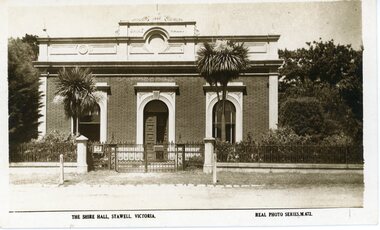
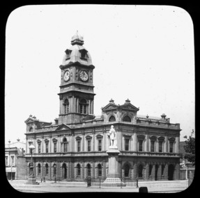
Photograph, Stawell Shire Hall 1866
Post card of the Stawell Shire Hall built 1866. The Shire Hall in Longfield Street Stawell has seen many changes over time. The building originally had a brick facade as seen in this photo. The post card also shows the changes in vegetation around the building. In front of the two arched front windows of the building are two tall Dracaena's possible planted in c 1890's. The decorative fence was not in very early photographs of the building but appears in photographs around c 1890. The post card is located in Albun 14, p.9.Black & white post card of the Stawell Shire Hall. The building has a brick facade with trees in the background. In front of the two arched front windows of the building are two tall Dracaena's either side of the entrance. There is a decorative fence with posts either side of the entrance gates to the building. The post card is located in Albun 14, p.9.The Shire Hall, Stawell Victoria. Real Photo Series. M. 672. on the back Valentines real photo series POST CARD branches Sydney London Dundee Capetown Montreal Toronto all in a box. Published by the Valentine & Sons Publishing Co.Ltd. Melbourne, Sydney & Brisbane.stawell -
 Flagstaff Hill Maritime Museum and Village
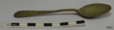
Domestic object - Spoon, Walker & Hall, C.1910-1920
This electroplated teaspoon made by Walker & Hall of Sheffield. It was recovered from an unknown shipwreck in the coastal waters of Victoria in the late 1960s to early 1970s. The shipwrecks in the area range from around the 1840s to the early 1930s. It is part of the John Chance Collection. Walker & Hall’s Marks on this teaspoon, the SHIELD and the FLAG, date the spoon between 1910 and before 1920. The letters, possibly N S, within a shield may stand for Nickel Silver. The first Sheffield licence to make electroplated pieces of work was granted to John Harrison in 1843. One of his employees, George Walker, had been sent to learn electroplating skills at Elkington’s in Birmingham, who had patented the process discovered by Dr John Wright. Walker left Harrison in 1845 and started up his own company with Samuel Coulson and William Robson, to become George Walker & Co., electro-platers and gilders, taking out a licence with Elkington’s. In 1848 Robson retired and Henry Hall joined the partnership, operating at Electro Works at 11 Howard Street Sheffield, with a showroom in at 45 Holborn Viaduct, London. The firm had changes in the partnership and by 1853 it was called Walker & Hall. Over the years the company grew, with branches in the UK and overseas in Australia and South Africa. Then John Bingham, and later his brother Charles Bingham, became involved in the business, increasing profits. In 1861 the firm registered its first Trademark, a stamped ‘Flag’ with a banner with letters ‘W & H’. In 1884 Walker & Hall were one of the largest manufacturers and the second to introduce a voluntary system of using dating marks for silver plate, based on the alphabet and styles of shields or figures. The firm grew and prospered. It was described as ‘comprehensive … touching almost every department of Social life’, selling all manner of silverware and other goods. In 1920 the firm became Walker & Hall Limited and continued to expand in the goods produced and the member employed. Then the effects of war brought economic depression and fewer people able to afford the quality luxury goods. Eventually, in 1963, the company amalgamated with Mappin & Webb and Elkington & Co., becoming British Silverware Ltd. Although the spoon is not linked to a particular shipwreck, it is recognised as being historically significant as an example of cutlery, perhaps part of a passenger’s luggage or imported for use in Victoria in the early 20th century. This spoon is significant for its association with makers Walker & Hall, famous for silverware and silver plate in the mid-19th to early-20th century. It is the only example in Flagstaff Hill’s shipwreck artefact collection. The spoon is also significant as it was recovered by John Chance, a diver in Victoria’s coastal waters in the late 1960s to early 1970s. Items that come from several wrecks have since been donated to the Flagstaff Hill Maritime Village’s museum collection by his family, illustrating this item’s level of historical value. Spoon, teaspoon, electroplated, silver-bronze colour with dark flecks. Old English design. Maker’s Marks on back of spoon. Made by Walker & Hall, Sheffield.Embossed individual stamps “W”, “&”, “H”, “S” Embossed shape [SHIELD] with letters within, possibly “N S” Embossed shape of [FLAG] with letters with “W & H” flagstaff hill maritime museum, maritime museum, shipwreck coast, flagstaff hill maritime village, great ocean road, shipwreck artefact, john chance, sheffield, cutlery, eating utensils, electroplate, silver plate, silverware, flatware, antique flatware, old english flatware pattern, spoon, teaspoon, silver flatware, dining, silver plated, epnns, 20th century silverware, walker & hall, george walker, henry hall, john wright, elkington -
 Stawell Historical Society Inc
Photograph, Main Street looking west from Bull & Mouth Hotel with Named Shops in the 2nd Photo -- 2 Photos c1907/08
Main Street Stawell c1907 Left is Bull & Mouth Hotel, Playfords, Whiteside & Co Taylors Carters Boot shop. On right Rotunda in distance, T Browns Furniture, George Mitchell, Norman A Harding, W.C. Barker Picture framing. Rose Series P 2725The Rose Series. P. 2725 Main Street, Stawell, Victoria stawell streetscape -
 Eltham District Historical Society Inc
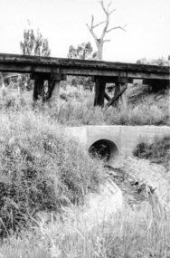
Photograph, Looking west from Main Road from just north of intersection with Diamond Street, Eltham, February 1968, Feb 1968
The watercourse passes under the road and railway at this point. Significant flash flooding occurred along this water course on Christmas Day 2011 causing significant damage to the railway line and road and flooding of Judge Book Village. The drain was swept away including the support pillars of the rail lines timber framework. Judge Book Village had some 40 units flooded before the water entered Diamond Creek. The water had flowed down and flooded Valonia Drive then Grove Street before flowing down the watercourse to Main RoadIn February 1968 an unknown person took a series of photos from the Eltham Hotel at Pitt Street heading north along Main Road through the shopping centre to just north of Elsa Court covering the length of the section of Main Road which was duplicated shortly thereafter. Shows the condition and environment of the streesscape of Main Road, Eltham immediately prior to the duplication between Pitt Street and Elsa Court through the shopping centre. Also shows a number of shops and businesses that operated at that time.Black and white photographduplication, eltham, main road, diamond street, watercourse, drainage, railway line -
 Warrnambool and District Historical Society Inc.
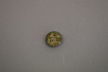
Badge, Panmure Hall Improvement
This badge was sold at a local fete to raise funds for improvements to the Panmure Hall. Panmure is a small town on the Princes Highway 22 kilometres north east of Warrnambool. In 1933 the population of Panmure was 273. The Panmure Hall still serves the community.This badge is of interest as an example of a local community effort to raise funds for local communities.Circular badge with cream background surrounded by a green rim. The text and a fan shaped medallion are also green. A black number is also featured. There is a clip pin on the reverse.PANMURE HALL IMPROVEMENT APPEAL FEB. 15-16. 1933 GRAND FETE 59 -
 Stawell Historical Society Inc
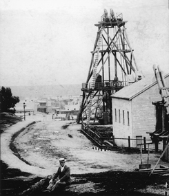
Photograph, Sloane's & Scotchman Mining Co Poppet Head in Upper Main Street Big Hill looking West. c1890
Gentleman sitting in front of Sloane's & Scotchman Mining Co Poppet Head Upper Main Street Big Hill looking West. Main Street visible in distance background.Poppet head above shaft and engine shed at right. Looking towards corner of Main and Lazelle Streets. Man seated at front centre of photo in boater hat.stawell mining, streetscape -
 Federation University Historical Collection
Photograph - Black and White Photograph, 1870 Founders Hall, Mount Helen Campus, 1981
In the course of celebrating the Ballarat School of Mines centenary in 1970, the School Coundil launched a building appeal for erection of a Great Hall at tehe then new Mount Helen campus of its tertiary division. In 1976 the tethertiary division of the School of Mines was, by government decision, merger with another tertiary institution in Ballarat to vreate the Ballarat College of Advanced Education while the remainder of the School of Mines continued to be based at Lydiard Street serving the needs of Technical and Further Education. The 1870s Founders Hall, erected from the provceeds of the Centenary Appeal for a sum of approximately $800,000, commemorats the intiative of the founders of the original School of Mines and its "descendants", including Ballarat C.A.E., as well as formal technical education in Australia. The hall accomodates approximately 670 people in theatre type seating and was intended for multiple purpose use by community groups as well as by the College. Construction of the Hall commenced in 1878. It was opened approximately 110 years after the opening of the Ballarat School of Mines, and 10 years after the opening of the Mount Helen campus.Photograph of Founder Halls, most probably taken soon after contruction.founder hall, caro conference centre, buildings, mount helen campus -
 Surrey Hills Historical Society Collection
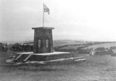
photograph, Ken Hall, Beckett Park Soldiers War Memorial c1932, c1980
Copy negative by Ken Hall from a c1933 City of Camberwell brochure. The original appears to have had a crease mark across it as this is evident on both copies.Black and white photo of the First World War memorial erected on the high point in Beckett Park, Balwyn. Taken with the memorial in the foreground and looking to the south-west. The Australian flag is flying on top of the monument and in the background are rows of trees dividing largely clear land.On the rear: Copy 1: "1153 Repeat of No 164" in top left hand corner in lead pencil in Jocelyn Hall's hand. Copy 2: "1153 Repeat of No 164" in top left hand corner in lead pencil in Jocelyn Hall's hand and "Soldiers War Memorial / Beckett Park / Erected 1918" in blue biro centre right.first world war, war memorial, beckett park -
 Ringwood and District Historical Society
Photograph, History of the Ringwood Salvation Army Hall and the discovery of the lost foundation stone. 1965-1997, 1. 1965|2. 1965|3. 1997
History of the Salvation Army Hall and the discovery of the lost foundation stone. Refer the accompanying article from the Interlink magazine (3546). Three photos.History of the Salvation Army Hall and the discovery of the lost foundation stone. Refer the accompanying article from the Interlink magazine (3546). Three photos as follows:; 1. Old Ringwood Salvation Army Hall 1926-1965.; 2. Move of hall to Mooroolbark 1965.; 3. Foundation stone being presented at Ringwood Historical Society 1997. -
 Stawell Historical Society Inc
Photograph, Stawell Shire Hall 1866 -- Coloured
View of the Stawell Shire Hall from the road way. The photo does not show the decorative fence around the front of the building as show in the previous photograph. Coloured photograph of the Stawell Shire Hall. A telegraph pole in front of a large tree can be seen on the left hand side with a flag post out the front of the building. There is no fence around the Shire Hall. stawell -
 Victorian Interpretive Projects Inc.
Photograph - colour, Lisa Gervasoni, Alexandra Shire Hall, Victoria, 2014, 2015
Alexandra was originally known as 'Red Gate' and was an 1860s gold rush settlement. The Alexandra Shire Hall was constructed in 1881. Three photographs of the Alexandra Shire Hall which features the Australian coat of arms. alexandra, red gate, coat of arms, kangaroo, emu -
 National Wool Museum
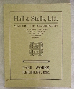
Book, Hall & Stells, Ltd, Makers of Machinery
"Hall & Stells, Ltd, Makers of Machinery, Park Works, Keighley, Eng", catalogue of machinery."Hall & Stells, Ltd, Makers of Machinery, Park Works, Keighley, Eng", catalogue of machinery.textile machinery, hall and stells limited -
 Eltham District Historical Society Inc
Minute Book, Eltham Public Hall Ladies Committee Minutes, 16 March 1939 to 14 March 1940, 1937-1941
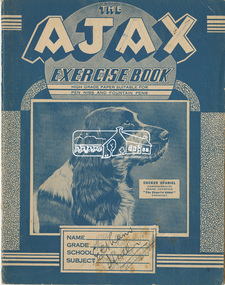
In September 1937, a group of ladies met to form a Ladies’ Committee to assist the General Committee in raising funds for a Public Hall. Those present were Mrs Allen, Mrs Bowman, Mrs Hickey, Mrs Rains, Mrs Boake and Mrs Lyon. As there were only six present, they elected to remain in the interim as a Social Committee to arrange catering, etc., for the two dances that had been arranged for September 29th and October 30th of that year. Both those dances proved a great success. Mrs McAdie joined the committee in October. The Ladies’ Committee was officially formed at a combined meeting of the General and Ladies’ committees held on April 6th, 1938. Mrs Boake agreed to be President, Mrs Lyon as Secretary and Mrs Rains as Assistant Secretary. Other members included Mrs Browne, Mrs Forde, Mrs Jarrold, Mrs Bradbury and Mrs Taylor. By 1941 their numbers had grown to include Matron Wilson, and Mesdames Andrew, Brinkkotter, Cloney, Walker, Parsons, Crick, Ballenger, Travena, Hurst, Shields and Le Brocq . A number of these ladies eventually became part of the Women’s Auxiliary of the Eltham War Memorial Trust. Councillor A. Brinkkotter, secretary of the Hall Committee, noted that Eltham had succeeded, after many long years of fighting, in erecting a new hall and civic centre which had been badly needed. “It took a long time to convince the Council of the necessity for a new hall and civic centre in Eltham.” “The councillors, in looking after the interests of all sections of the rate payers, could not see that such a move was necessary. But finally the Hall Committee proved that such a move was not only advisable, but would prove a financial asset to the Shire.” “This committee had to put down £1,500 in cash before the work on the hall began, and to enable the committee to do this, residents loaned them money free of interest for 12 months. In addition the committee has guaranteed to pay the Council £100 a year for the next ten years.” “The borrowed money has to be repaid to the lenders, and I hope that the public will realise this and support the functions which have been and will be arranged by the Hall Committee to enable them to return the money as soon, as possible.” At the opening gala for the Public Hall, Mr. G. L. Chandler, M.L.C. said “It speaks volumes for those people who have worked for many years for the hall. I know of no other place where the residents have handed over £1,500 for the erection of a hall and guaranteed the balance of the cost. You will always find the few who say ‘Time is not opportune.’ In these days you have to make your opportunities.” “Before any town can advance, a civic spirit must exist in the residents, and I hope the people will support the Hall Committee which has the interests of this district at heart.”Background workings for the funding of a Public Hall at Eltham. The funding was provided by public subscription and the money loaned to Council to build the hall. The hall was part of the new Eltham Shire offices located at the corner of Main Road and Arthur Street. A similar funding approach was used a few years later to provide for the Eltham War Memorial located on the opposite side of Main Road.The Ajax Exercise Book, faint lined each page, 24 pages with handwriting in ink; last six pages blank"Eltham Hall" written in ink on top of pencil stating "Mrs Lyon"arthur street, eltham public hall, eltham public hall ladies committee, main road, maria street, minute book -
 Bacchus Marsh & District Historical Society
Map, Main Road and Gell Street Allotments
This map shows allotments of land along Gell Street Bacchus Marsh running between Main Road (now called Main Street) and Lerderderg Street. The total area of the map encompasses Main Road, Church Street, Lerderderg Street and Gell Street. 36 allotments of land are shown. Three allotments which connect to Main Road are shaded in pink. The date of the map has not been established but the National Bank building erected in 1865 near the Border Inn is indicated which indicates that the map dates from after 1865. Reports in the Bacchus Marsh Express newspaper on 5 March 1870, page 2, column 6 announced building lots in Gell Street had been withdrawn from sale by the agent J.E. Crook. Later reports in the Express on 1 November 1873, page 2, column 2 advertised 14 allotments of land in Gell Street for sale. Single page map showing allotments of land along the Main Road (Main Street) and Gell Street areas of Bacchus Marsh. Part of a set of maps which are pasted into a bound volume containing 76 maps or plans in total. High resolution digital image stored on BMDHS computer network. bacchus marsh victoria maps, gell street land allotments, main street land allotments -
 Eltham District Historical Society Inc
Photograph, Former Eltham Police Residence, 728 Main Road, Eltham, c.1985, 1985c
This photo is believed to have been taken circa 1985 when the Shire of Eltham Parks and Environment occupied the site. This photo was originally mounted on 3mm MDF fibre board with notes and stickers applied as part of a display on the former Police Residence and now present day Local History Centre, home to Eltham District Historical Society; possibly put together by Harry Gilham during his time as president of the society. Eltham Police Station and Residence: A brief history 1860 Eltham Courthouse built in Main Road, together with an adjoining police residence, office, lock–up and stables. 1959 Police Department purchases a house in Pryor Street to be refurbished as Eltham Police Station 1961 Police in Eltham move into Pryor Street refurbished buildings and office. c.1961-1981 Occupied by Vermin and Noxious Weeds Destruction Section of the Department of Crown Lands and Survey. Former Police Station dragged around to rear of Police Residence (prior to August 1967) to make way for the construction of a driveway and access from Main Road. The building was placed on the site of a former Scullery and modified for Lands Department use. 1981 Shire of Eltham take over management of old Police Residence in Eltham. It remains unoccupied for a period of time whilst its future is discussed in Council. 1981-1985 Used for community job creation scheme 1985 Shire of Eltham Parks and Environment occupy the residence. Council improve the driveway but later add a second rear access from Brougham Street due to the dangerous nature of the Main Road entrance. Also add a rear toilet facility between the Police Residence and former Police Station, which was doubling up as a lunch room. Council also commence discussions to re-establish a replica Police Station. c.1986 November. Former Police Station demolished; believed to have been suffering termite damage. c.1989 After some years of discussion a replica Police Station is built, based on photographs, to act as a lunch room and meeting room for Parks and Environment staff and volunteers doing community service. 1996 Eltham District Historical Society in discussions with Nillumbik Shire Council commisioners throughout the year regarding a home for the Society. A proposal put forward by the Society in October to occupy the former Police Residence. 1997 March. Eltham District Historical Society gains access to former Police Residence. 1998 July 12th. Eltham District Historical Society Inc moves into its Local History Centre, 728 Main Road Eltham (the former Police Residnce built in 1860). 2018 July. Eltham District Historical Society gains access to the replica Police Station for use as part of regular heritage tours for schools and community based groups.Colour printHandwritten in faded blue felt pen ink "No. 3 - Front of 728 Police Residence. 1860 Court House over the paling fence. Verandah missing from earlier photographs"728 main road, eltham, local history centre, parks and environment, police residence, police station, shire of eltham -
 Eltham District Historical Society Inc
Photograph, Former Eltham Police Residence, 728 Main Road, Eltham, c.1985, 1985c
This photo is believed to have been taken circa 1985 when the Shire of Eltham Parks and Environment occupied the site. This photo was originally mounted on 3mm MDF fibre board with notes and stickers applied as part of a display on the former Police Residence and now present day Local History Centre, home to Eltham District Historical Society; possibly put together by Harry Gilham during his time as president of the society. Eltham Police Station and Residence: A brief history 1860 Eltham Courthouse built in Main Road, together with an adjoining police residence, office, lock–up and stables. 1959 Police Department purchases a house in Pryor Street to be refurbished as Eltham Police Station 1961 Police in Eltham move into Pryor Street refurbished buildings and office. c.1961-1981 Occupied by Vermin and Noxious Weeds Destruction Section of the Department of Crown Lands and Survey. Former Police Station dragged around to rear of Police Residence (prior to August 1967) to make way for the construction of a driveway and access from Main Road. The building was placed on the site of a former Scullery and modified for Lands Department use. 1981 Shire of Eltham take over management of old Police Residence in Eltham. It remains unoccupied for a period of time whilst its future is discussed in Council. 1981-1985 Used for community job creation scheme 1985 Shire of Eltham Parks and Environment occupy the residence. Council improve the driveway but later add a second rear access from Brougham Street due to the dangerous nature of the Main Road entrance. Also add a rear toilet facility between the Police Residence and former Police Station, which was doubling up as a lunch room. Council also commence discussions to re-establish a replica Police Station. c.1986 November. Former Police Station demolished; believed to have been suffering termite damage. c.1989 After some years of discussion a replica Police Station is built, based on photographs, to act as a lunch room and meeting room for Parks and Environment staff and volunteers doing community service. 1996 Eltham District Historical Society in discussions with Nillumbik Shire Council commisioners throughout the year regarding a home for the Society. A proposal put forward by the Society in October to occupy the former Police Residence. 1997 March. Eltham District Historical Society gains access to former Police Residence. 1998 July 12th. Eltham District Historical Society Inc moves into its Local History Centre, 728 Main Road Eltham (the former Police Residnce built in 1860). 2018 July. Eltham District Historical Society gains access to the replica Police Station for use as part of regular heritage tours for schools and community based groups.Colour printHandwritten in faded blue felt pen ink "No. 2 - Backyard of 728 #5 Weatherboard 'Office'. Note 1860 Court House over the fence."728 main road, eltham, local history centre, parks and environment, police residence, police station, shire of eltham -
 Eltham District Historical Society Inc
Photograph, Former Eltham Police Residence, 728 Main Road, Eltham, c.1985, 1985c
This photo is believed to have been taken circa 1985 when the Shire of Eltham Parks and Environment occupied the site. This photo was originally mounted on 3mm MDF fibre board with notes and stickers applied as part of a display on the former Police Residence and now present day Local History Centre, home to Eltham District Historical Society; possibly put together by Harry Gilham during his time as president of the society. Eltham Police Station and Residence: A brief history 1860 Eltham Courthouse built in Main Road, together with an adjoining police residence, office, lock–up and stables. 1959 Police Department purchases a house in Pryor Street to be refurbished as Eltham Police Station 1961 Police in Eltham move into Pryor Street refurbished buildings and office. c.1961-1981 Occupied by Vermin and Noxious Weeds Destruction Section of the Department of Crown Lands and Survey. Former Police Station dragged around to rear of Police Residence (prior to August 1967) to make way for the construction of a driveway and access from Main Road. The building was placed on the site of a former Scullery and modified for Lands Department use. 1981 Shire of Eltham take over management of old Police Residence in Eltham. It remains unoccupied for a period of time whilst its future is discussed in Council. 1981-1985 Used for community job creation scheme 1985 Shire of Eltham Parks and Environment occupy the residence. Council improve the driveway but later add a second rear access from Brougham Street due to the dangerous nature of the Main Road entrance. Also add a rear toilet facility between the Police Residence and former Police Station, which was doubling up as a lunch room. Council also commence discussions to re-establish a replica Police Station. c.1986 November. Former Police Station demolished; believed to have been suffering termite damage. c.1989 After some years of discussion a replica Police Station is built, based on photographs, to act as a lunch room and meeting room for Parks and Environment staff and volunteers doing community service. 1996 Eltham District Historical Society in discussions with Nillumbik Shire Council commisioners throughout the year regarding a home for the Society. A proposal put forward by the Society in October to occupy the former Police Residence. 1997 March. Eltham District Historical Society gains access to former Police Residence. 1998 July 12th. Eltham District Historical Society Inc moves into its Local History Centre, 728 Main Road Eltham (the former Police Residnce built in 1860). 2018 July. Eltham District Historical Society gains access to the replica Police Station for use as part of regular heritage tours for schools and community based groups.Colour printHandwritten in faded blue felt pen ink "Roof of room 5 (weatherboard office) and W.C. See No. 2 for another view"728 main road, eltham, local history centre, parks and environment, police residence, police station, shire of eltham -
 Eltham District Historical Society Inc
Photograph, Former Eltham Police Residence, 728 Main Road, Eltham, c.1985, 1985c
This photo is believed to have been taken circa 1985 when the Shire of Eltham Parks and Environment occupied the site. This photo was originally mounted on 3mm MDF fibre board with notes and stickers applied as part of a display on the former Police Residence and now present day Local History Centre, home to Eltham District Historical Society; possibly put together by Harry Gilham during his time as president of the society. Eltham Police Station and Residence: A brief history 1860 Eltham Courthouse built in Main Road, together with an adjoining police residence, office, lock–up and stables. 1959 Police Department purchases a house in Pryor Street to be refurbished as Eltham Police Station 1961 Police in Eltham move into Pryor Street refurbished buildings and office. c.1961-1981 Occupied by Vermin and Noxious Weeds Destruction Section of the Department of Crown Lands and Survey. Former Police Station dragged around to rear of Police Residence (prior to August 1967) to make way for the construction of a driveway and access from Main Road. The building was placed on the site of a former Scullery and modified for Lands Department use. 1981 Shire of Eltham take over management of old Police Residence in Eltham. It remains unoccupied for a period of time whilst its future is discussed in Council. 1981-1985 Used for community job creation scheme 1985 Shire of Eltham Parks and Environment occupy the residence. Council improve the driveway but later add a second rear access from Brougham Street due to the dangerous nature of the Main Road entrance. Also add a rear toilet facility between the Police Residence and former Police Station, which was doubling up as a lunch room. Council also commence discussions to re-establish a replica Police Station. c.1986 November. Former Police Station demolished; believed to have been suffering termite damage. c.1989 After some years of discussion a replica Police Station is built, based on photographs, to act as a lunch room and meeting room for Parks and Environment staff and volunteers doing community service. 1996 Eltham District Historical Society in discussions with Nillumbik Shire Council commisioners throughout the year regarding a home for the Society. A proposal put forward by the Society in October to occupy the former Police Residence. 1997 March. Eltham District Historical Society gains access to former Police Residence. 1998 July 12th. Eltham District Historical Society Inc moves into its Local History Centre, 728 Main Road Eltham (the former Police Residnce built in 1860). 2018 July. Eltham District Historical Society gains access to the replica Police Station for use as part of regular heritage tours for schools and community based groups.Colour printHandwritten in faded blue felt pen ink "Another view of north wall 728 No. 4. Taken from west end towards back yard"728 main road, eltham, local history centre, parks and environment, police residence, police station, shire of eltham -
 Eltham District Historical Society Inc
Photograph, Former Eltham Police Residence, 728 Main Road, Eltham, c.1985, 1985c
This photo is believed to have been taken circa 1985 when the Shire of Eltham Parks and Environment occupied the site. This photo was originally mounted on 3mm MDF fibre board with notes and stickers applied as part of a display on the former Police Residence and now present day Local History Centre, home to Eltham District Historical Society; possibly put together by Harry Gilham during his time as president of the society. Eltham Police Station and Residence: A brief history 1860 Eltham Courthouse built in Main Road, together with an adjoining police residence, office, lock–up and stables. 1959 Police Department purchases a house in Pryor Street to be refurbished as Eltham Police Station 1961 Police in Eltham move into Pryor Street refurbished buildings and office. c.1961-1981 Occupied by Vermin and Noxious Weeds Destruction Section of the Department of Crown Lands and Survey. Former Police Station dragged around to rear of Police Residence (prior to August 1967) to make way for the construction of a driveway and access from Main Road. The building was placed on the site of a former Scullery and modified for Lands Department use. 1981 Shire of Eltham take over management of old Police Residence in Eltham. It remains unoccupied for a period of time whilst its future is discussed in Council. 1981-1985 Used for community job creation scheme 1985 Shire of Eltham Parks and Environment occupy the residence. Council improve the driveway but later add a second rear access from Brougham Street due to the dangerous nature of the Main Road entrance. Also add a rear toilet facility between the Police Residence and former Police Station, which was doubling up as a lunch room. Council also commence discussions to re-establish a replica Police Station. c.1986 November. Former Police Station demolished; believed to have been suffering termite damage. c.1989 After some years of discussion a replica Police Station is built, based on photographs, to act as a lunch room and meeting room for Parks and Environment staff and volunteers doing community service. 1996 Eltham District Historical Society in discussions with Nillumbik Shire Council commisioners throughout the year regarding a home for the Society. A proposal put forward by the Society in October to occupy the former Police Residence. 1997 March. Eltham District Historical Society gains access to former Police Residence. 1998 July 12th. Eltham District Historical Society Inc moves into its Local History Centre, 728 Main Road Eltham (the former Police Residnce built in 1860). 2018 July. Eltham District Historical Society gains access to the replica Police Station for use as part of regular heritage tours for schools and community based groups.Colour printHandwritten in faded blue felt pen ink "Repeat view of No. 4 from external corner of weatherboard extn. Room 5"728 main road, eltham, local history centre, parks and environment, police residence, police station, shire of eltham -
 Eltham District Historical Society Inc
Photograph, Former Eltham Police Residence, 728 Main Road, Eltham, c.1985, 1985c
This photo is believed to have been taken circa 1985 when the Shire of Eltham Parks and Environment occupied the site. This photo was originally mounted on 3mm MDF fibre board with notes and stickers applied as part of a display on the former Police Residence and now present day Local History Centre, home to Eltham District Historical Society; possibly put together by Harry Gilham during his time as president of the society. Eltham Police Station and Residence: A brief history 1860 Eltham Courthouse built in Main Road, together with an adjoining police residence, office, lock–up and stables. 1959 Police Department purchases a house in Pryor Street to be refurbished as Eltham Police Station 1961 Police in Eltham move into Pryor Street refurbished buildings and office. c.1961-1981 Occupied by Vermin and Noxious Weeds Destruction Section of the Department of Crown Lands and Survey. Former Police Station dragged around to rear of Police Residence (prior to August 1967) to make way for the construction of a driveway and access from Main Road. The building was placed on the site of a former Scullery and modified for Lands Department use. 1981 Shire of Eltham take over management of old Police Residence in Eltham. It remains unoccupied for a period of time whilst its future is discussed in Council. 1981-1985 Used for community job creation scheme 1985 Shire of Eltham Parks and Environment occupy the residence. Council improve the driveway but later add a second rear access from Brougham Street due to the dangerous nature of the Main Road entrance. Also add a rear toilet facility between the Police Residence and former Police Station, which was doubling up as a lunch room. Council also commence discussions to re-establish a replica Police Station. c.1986 November. Former Police Station demolished; believed to have been suffering termite damage. c.1989 After some years of discussion a replica Police Station is built, based on photographs, to act as a lunch room and meeting room for Parks and Environment staff and volunteers doing community service. 1996 Eltham District Historical Society in discussions with Nillumbik Shire Council commisioners throughout the year regarding a home for the Society. A proposal put forward by the Society in October to occupy the former Police Residence. 1997 March. Eltham District Historical Society gains access to former Police Residence. 1998 July 12th. Eltham District Historical Society Inc moves into its Local History Centre, 728 Main Road Eltham (the former Police Residnce built in 1860). 2018 July. Eltham District Historical Society gains access to the replica Police Station for use as part of regular heritage tours for schools and community based groups.Colour printHandwritten in faded blue felt pen ink "Backdoor to residence. White paint still visible 2010 on brickwork"728 main road, eltham, local history centre, parks and environment, police residence, police station, shire of eltham -
 Eltham District Historical Society Inc
Photograph, Former Eltham Police Residence, 728 Main Road, Eltham, c.1985, 1985c
This photo is believed to have been taken circa 1985 when the Shire of Eltham Parks and Environment occupied the site. This photo was originally mounted on 3mm MDF fibre board with notes and stickers applied as part of a display on the former Police Residence and now present day Local History Centre, home to Eltham District Historical Society; possibly put together by Harry Gilham during his time as president of the society. Eltham Police Station and Residence: A brief history 1860 Eltham Courthouse built in Main Road, together with an adjoining police residence, office, lock–up and stables. 1959 Police Department purchases a house in Pryor Street to be refurbished as Eltham Police Station 1961 Police in Eltham move into Pryor Street refurbished buildings and office. c.1961-1981 Occupied by Vermin and Noxious Weeds Destruction Section of the Department of Crown Lands and Survey. Former Police Station dragged around to rear of Police Residence (prior to August 1967) to make way for the construction of a driveway and access from Main Road. The building was placed on the site of a former Scullery and modified for Lands Department use. 1981 Shire of Eltham take over management of old Police Residence in Eltham. It remains unoccupied for a period of time whilst its future is discussed in Council. 1981-1985 Used for community job creation scheme 1985 Shire of Eltham Parks and Environment occupy the residence. Council improve the driveway but later add a second rear access from Brougham Street due to the dangerous nature of the Main Road entrance. Also add a rear toilet facility between the Police Residence and former Police Station, which was doubling up as a lunch room. Council also commence discussions to re-establish a replica Police Station. c.1986 November. Former Police Station demolished; believed to have been suffering termite damage. c.1989 After some years of discussion a replica Police Station is built, based on photographs, to act as a lunch room and meeting room for Parks and Environment staff and volunteers doing community service. 1996 Eltham District Historical Society in discussions with Nillumbik Shire Council commisioners throughout the year regarding a home for the Society. A proposal put forward by the Society in October to occupy the former Police Residence. 1997 March. Eltham District Historical Society gains access to former Police Residence. 1998 July 12th. Eltham District Historical Society Inc moves into its Local History Centre, 728 Main Road Eltham (the former Police Residnce built in 1860). 2018 July. Eltham District Historical Society gains access to the replica Police Station for use as part of regular heritage tours for schools and community based groups.Colour printHandwritten in faded blue felt pen ink "No. 1 South wall of 728 & back of house built 1860 [1859]. Demolition of weatherboard extension into yard area"728 main road, eltham, local history centre, parks and environment, police residence, police station, shire of eltham -
 Whitehorse Historical Society Inc.
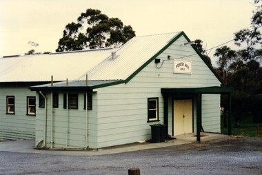
Photograph, Forest Hill Hall
The Forest Hill Hall was built before the 1960s and is situated on the South East side of the intersection of Canterbury and Springvale Rds.The hall seats 70 and can supply tables chairs and a stove. The floor is timber and there is a disability access. There are no parties allowedColoured photograph of a green building with a yellow door. Forest Hill Hall is printed on a board above the doorforest hill hall, halls -
 Ballarat Heritage Services
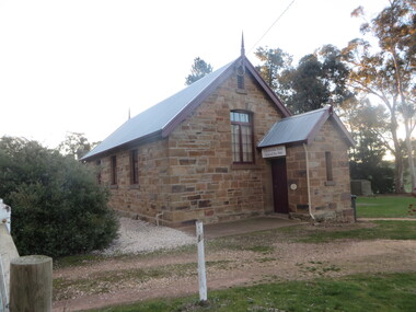
Photograph - Colour, Clare Gervasoni, Former Clydesdale State School (now Clydesdale Hall), 2018, 14/05/2018
The Clydesdale War Memorial is an obelisk situated in the Clydesdale State Shool grounds (now the Clydesdale Hall). The 150th anniversary of the Clydesdale State School/Hall was celecbrated in 2017. A number of colour photograph of a sandstone building that was built of local stone as the Clydesdale State School (SS900). It is now the Clydesdale Hall. clydesdale, world war one, world war two, clydesdale state school, clydesdale hall, sandstone -
 Chelsea & District Historical Society Inc
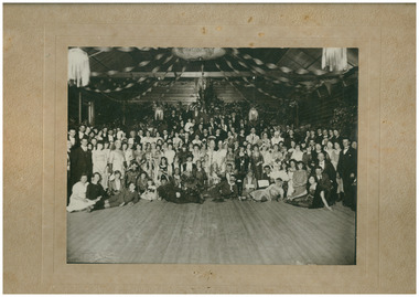
Photograph - St Chad's Church of England, Chelsea, Masquerade Ball in Kismet Hall, c 1920's
St Chad's Church of England congregation and friends attend a ball at Kismet Hall Kismet Hall was built by Mr Walker on his property adjoining the "Kismet" tea rooms in 1914, in the Strand, Chelsea.Sepia photo of members and friend of Chad's Church of England attending a Masquerade ball at Kismet Hall, in the Strand, Chelsea. Church of England, Chelseachurch of england, anglican, religion, building, church, chelsea, kismet hall, masquerade ball -
 St Kilda Historical Society
Postcard, Sears Studio, First St Kilda Town Hall, 1930
First St Kilda Town Hall, Cnr Grey and Barkly Sts, St Kilda, built in 1859, demolished 1930, side viewblack and white photograph, copy, fair image quality, unmountedOld Town Hall Crs Barkly & Grey St built 1859 -
Port Melbourne Historical & Preservation Society
Book - Register of visitors, Cleary, Borough Librarian, "Port Melbourne" Free "Library" "Town Hall" 21/ll/89, 1889 - 1890
Register of visitors to the Port Melbourne Free Library at the Town Hall, from 21.11.1889 to 29.07.1890, listing name and suburb (See also 1840*)On front cover label in script, '"Port Melbourne" Free "Library" "Town Hall" 21/ll/89', plus 'Mr. Cleary Librarian'port melbourne library, port melbourne town hall, local government - borough of port melbourne, cleary, port melbourne free library -
 City of Ballarat Libraries
Glass Slide, Ballarat Town Hall
Town Hall completed 1872. Thomas Moore statue erected 1889. No evidence of electric trams indicates the photograph is pre-1905.Previously unknown image of Ballarat. The set and its subjects indicate these images were produced to promote Ballarat and were perhaps aimed at tourists.Ballarat Town Hall, se corner Sturt and Armstrong Streets, image not dated. gas lamps, statue -
 Ballarat Heritage Services
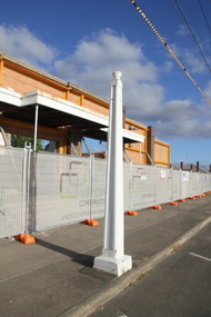
Photograph - Colour, Clare Gervasoni, Facade of the Former Sebastopol Town Hall During Building Works, 2018, 12/03/2018
The old Sebastopol Town Hall was erected in 1868 and opened on 19 March, 1869. The newer Town Hall was rebuilt in the 1950s and opened on 20 December 1960. The building was demolished except for the facade to build a new library in Sebastopol. The $2.8 million redeveloped Sebastopol Library Community Hub opend its doors to the community on Wednesday 2 January, 2019. This major redevelopment has transformed the City of Ballarat’s Library and Maternal and Child Health services into a vibrant modern community hub, Photographs of the facade of the former Sebastopol Town Hall, and the remains fo the old Sebastopol Town Hall revealed during renovations in 2018. The two white poles, donated by former mayors are also depicted. The two white poles at the front of the biulding include a plaque "Presented by the mayor Cr F.W. Miller, 1934"sebastopol, sebastopol town hall, sebastopol civic centre, sebastopol community centre, f.w. miller