Showing 13967 items
matching orbost-planning
-
 Orbost & District Historical Society
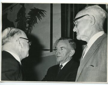
black and white photograph, 1962
This photograph was taken at the Orbost High School Golden Jubilee celebrations in 1962. It shows Crs Truscott, Mr R. Osborne (1960-1963 Orbost High School Headmaster, and Mr George Cameron.Orbost High School / Orbost Secondary College has played a significant part in the education of senior students in the Orbost district . It is the sole senior educational institution. A black / white photograph of three men in suits.on back - hand-written -" Orbost H.S. Jubilee, 1962, Crs. Truscott, Osbourne & Geo. Cameron"education-orbost orbost-high-school -
 Orbost & District Historical Society
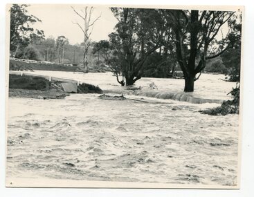
black and white photograph, February, 1971
This photograph shows the floodwaters during the 1971 flood at Orbost. The two mahogany trees in the photograph stopped the Snowy River from changing its course. The 1971 flood was the the worst flood on record. At Jarrahmond it was at least 11 metres and up to one and a half kilometres wide on the flats causing enormous damage to the flood plain. Records say that "The brown floodwater stain in Bass Strait could be seen from passing airliners." Considerable damage was done to railway infrastructure, roads and farms. More information from the APRIL, 2008 newsletter by John Phillips. (see orbosthistory.com.au)This is a pictorial record of a significant event in the history of floods in Orbost.A black / white photograph of raging floodwaters at the bottom of the Orbost township.orbost-flood-1971 -
 Melbourne Tram Museum
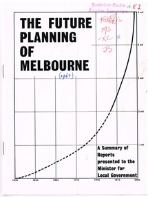
Document - Report, Commerce News, "The Future Planning of Melbourne - A summary of Reports - Minister for Local Government", 1967
... "The Future Planning of Melbourne - A summary of Reports ...Printed report or paper, 16 pages on gloss paper, centre stapled titled "The Future Planning of Melbourne - A summary of Reports presented to the Minister for Local Government" looking at the growth of Melbourne, water supply, metropolitan boundaries, 1966-67. Includes submissions from Town and Country Planning Association, MMBW, Regional planning, decentralisation, finance, commuter services. Process created by Rupert Hamer, the Local Government Minister at the time. Published as a supplement to "January Commerce News.""4E1" in ink on front cover, AETA stamp, the date "(1967)" and peoples initials on the front cover.trams, tramways, melbourne, victoria, development -
 Federation University Historical Collection
Booklet - Report, Regional College Development Planning Paper, 1976
... Regional College Development Planning Paper, 1976 ...Ballarat School of Mine's 'Regional College Development Plan' for the Lydiard Street Campus. It includes minutes of meeting in 1976.ballarat school of mines, ballarat regional college, graham beanland, ballarat technical school, ballarat girls'high school, mount clear technical high school, tertiary orientation program, campus plan, smb campus plan -
Federation University Historical Collection
Report, Echuca Moama Tourism Planning and Development Strategy, c1996
... Echuca Moama Tourism Planning and Development Strategy ...Report compiled by three students of 'Tourism Planning and Development' at Ballarat University College (later Federation University Australia).victorian tourism industry, tourism, alumni, echuca, moama, hopwood's ferry, murray river, goulburn river, campaspe river, gaming -
 Federation University Historical Collection
Report, Echuca Moama Tourism Planning and Development Strategy, 1993, 06/1993
... Echuca Moama Tourism Planning and Development Strategy ...Report compiled by four students of 'Tourism Planning and Development' at Ballarat University College (later Federation University Australia).victorian tourism industry, tourism, alumni, echuca, moama, hopwood's ferry, murray river, goulburn river, campaspe river, gaming, port of echuca -
Whitehorse Historical Society Inc.
Document, City of Nunawading Forward Planning Special Committee, 1/07/1994 12:00:00 AM
... City of Nunawading Forward Planning Special Committee ...Notice and agenda of Forward planning Committee includes items re Amalgamation submission and proposed names for merged city.Notice and agenda of Forward planning Committee includes items re Amalgamation submission and proposed names for merged city.Notice and agenda of Forward planning Committee includes items re Amalgamation submission and proposed names for merged city.city of nunawading, local government, amalgamations -
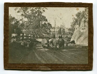 Orbost & District Historical Society
black and white photograph, C1900
Pigs were taken to Bairnsdale by coaxing them with maize thrown from a wagonette . From Bairnsdale they were freighted to market by train. The journey to Bairnsdale took about five days . This method of transport continued until the rail line to Orbost was opened in 1916.This photograph is a pictorial record of farming practices in the early 20th century.A black / white photograph on a brown buff card showing pigs being taken to market. The photograph shows the pigs close up with men on horseback behind them. The pigs are on a gravel road with a fence on one side and and the Orbost flats can be seen in the background.on back - "Pigs being driven from Orbost to Bairnsdale. M.Gilbert, Orbost"agriculture farming-orbost pigs -
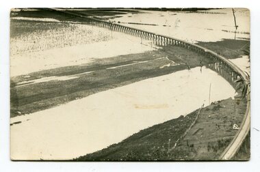 Orbost & District Historical Society
black and white photographs, second half 20th century
3154.1 is a postcard of the Orbost viaduct over the flooded Snowy River flats. 4153.2 is of a goods train on the viaduct. 3154.3 is of a loaded goods train with the driver at the window. Two men are standing on the plate and there are two workers below where there is some water and flood debris. 3154.4 is of amachine moving flood debris on the rail line. 3154.5 shows flood damage to the viaduct across the Snowy River flats. Two men are driving a dozer.This item is associated with the history of the Orbost-Bairnsdale railway line and therefore reflects the role that the rail line played in the social and economic history of Orbost.Five black / white photographs associated with the Orbost railway line during a flood.orbost-railway east-gippsland -railway orbost-floods -
 Orbost & District Historical Society
documents in folder, 1958-1964
These documents belonged to the Orbost Rifle Club.The Orbost Rifle Club existed in the early 20th century. (There are records from 1900). It folded in the late 1970's. It had a substantial membership.A light blue folder containing carbon copies of reports from the president of the Orbost Rifle Club from 1958-1964. The folder also contains correspondence from the Australian Rifle Association.orbost-rifle-club shooting documents -
 Glen Eira City Council History and Heritage Collection
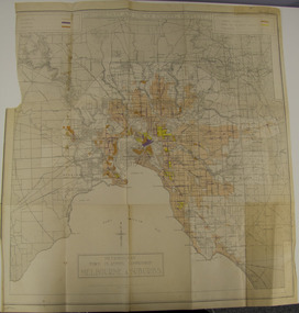
Map - Map, zoning, Metropolitan Town Planning Commission, "DISTRIBUTION AND USE OF EXISTING PROPERTY. MAP NO. 6.", 1929
... Metropolitan Town Planning Commission ...The map titled: “Distribution and use of Existing property map No. 6” (Metropolitan Town Planning Commission Melbourne and Suburbs) is of historical significance. It is listed on page 168 of Chapter 4 the Zoning section of the "Plan of General Development Melbourne Report of the Metropolitan Town Planning Commission 1929" - Melbourne's first strategic plan. Map No. 6 is mentioned throughout Chapter 4 of the 1929 Report. It states on page 156 that this Map was created to graphically illustrate the data collected by the Planning Commission. The Map illustrates the general distribution of uses of existing property throughout the metropolitan area. The coloured sections show the areas which were developed or were in the process of development in 1929. The colours indicate the distribution of uses in the developed areas. The pink coloured areas, which include Caulfield, were almost completely residential.1929, metropolitan town planning commission, melbourne, suburbs -
 Orbost & District Historical Society
newspaper article, January 31 1991
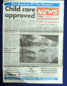
On 24 January 1991 a severe hailstorm occurred in Orbost. The Insurance Council of Australia estimated the 1991 damage at $12 million.This is a contemporary record of a significant event in Orbost.The front and back page of The East Gippsland News dated Thursday January 1991. The main article is a photograph of the hailstorm damage to Nicholson Street in Orbost.hailstorm-orbost east-gippsland-news newspaper-article -
 Orbost & District Historical Society
book, The Curlip No : 5, August 2007
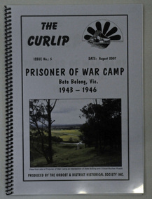
This book was compiled after an Orbost Historical Society bus trip to the site of the Prisoner of War Camp at Bete Bolong.This is a locally produced history book which is a useful reference for research into the history of Orbost.A 26 pp spiral bound book with a pale grey cover titled THE CURLIP NO 5, PRISONER OF WAR CAMP, Bete Bolong, Vic. 1943-1946. On the front cover in the top right hand corner is black sketch of a large paddle wheel with the P.S. Curlip in front of it. There is a coloured photograph of the view from the site of the P.O.W. Camp at the intersection of Bete Bolong and Buchan Roads.orbost-history bete-bolong ww11 prisoner-of-war-camp italian-prisoners -
Lakes Entrance Historical Society
Book, Gippsland Lakes Use Strategy Plan Background Report, 1978
... Town and Country Planning Board Melbourne ...Background report from Planning Board 1978Paperback with 125 pagestownships, planning committee -
 Lakes Entrance Historical Society
Photograph - Building of PS Curlip, 1/01/2006 12:00:00 AM
building of PS Curlip replica in old butter factory building Orbost VictoriaBuilt as tourist attraction on river at Marlo. Plus 6 other photos Colour photograph showing building of PS Curlip replica in old butter factory building Orbost Victoria. Plus 9 other photos tourism, boat building -
 Orbost & District Historical Society
soda syphon bottle, first half 20th century
Dross Drossou established a cordial factory in Orbost in the 1930s. He sold his cordial manufacturing business to Phillips and Stone, a Bairnsdale company, in 1948. Glass bottles were refillable until the 1960s, creating a demand for their collection and onsale back to beverage manufacturers via ‘bottle merchants’. A deposit on the bottles was added to all sales as they left the factory. The returned bottles were washed and the old label removed. The inside was cleaned by pushing the bottle onto a revolving brush. The reusing of the bottles went on until the bottle was broken or the top became chipped. This bottle is an example of a product manufacture by a local industry no longer existing.A clear glass soda syphon bottle. It has a red syphon pump.D.DROSSOU, ORBOST Soda Watersyphon-bottle drosseau -
 Orbost & District Historical Society
black and white photographs, 1960s - 1970s
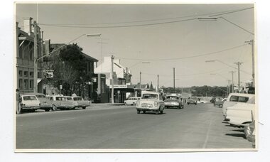
3289.1 has been taken in the main street of Orbost - Nicholson Street. 3289.2 has been taken on the outskirts of Orbost and indicates that the town population at the time was 2800.These photographs are pictorial record of Orbost C1960s - 1970s.3289.1 is a black / white photograph of a main street with cars parked on both sides of the road and buildings on the left hand side. 3289.2 is a black / white photograph of town entry sign - "ORBOST POP. 2800".orbost-nicholson-street main-street-orbost entry-sign-orbost orbost-1960s-1970s -
 Greensborough Historical Society
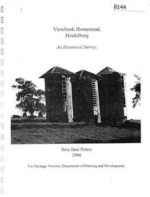
Booklet, Sera Jane Peters, Viewbank Homestead, Heidelberg: an historical survey, by Sera Jane Peters for Heritage Victoria, Department of Planning and Development, 1996
... Sera Jane Peters for Heritage Victoria, Department of Planning ...History of the Viewbank Homestead, originally a 90 acre site with homestead and outbuildings, now demolished.Black and white photocopy of typescript, with photographs, plans, reproductions of documents. 25 p plus 17 p of Appendices, unboundviewbank homestead, heritage victoria -
Ringwood and District Historical Society
Envelope, Packet: Town Planning Act 1944 and Greater Melbourne Printed Matter and Correspondence
... Packet: Town Planning Act 1944 and Greater Melbourne ...Packet 2 (of 2); Town Planning Act 1944 Municipal Administration Institute Pamphlets and minutes of general meetings; Correspondence -
 Stawell Historical Society Inc
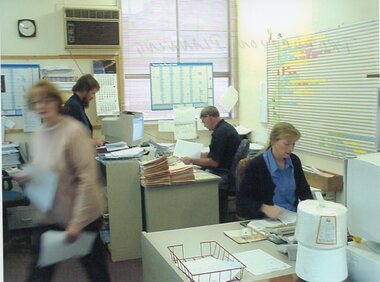
Photograph - Aunde Album 29, Production Planning, 2002
... Production Planning ...Aunde / Norwellan Textiles North Western Woolen Mills became Norwellan Textiles then AUNDEColour landscape photo: Office, 2 Women, 2 Men, planning calanders, file, computers, clock 1.50 PM.AUnde Australia Ltd. logoindustry, aunde -
 Camberwell Historical Society
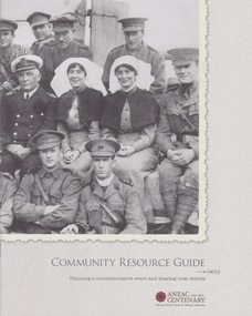
Booklet (Item), Victorian Government, Community Resource Guide: Planning a commemorative event and sharing local stories, 2014
... Community Resource Guide: Planning a commemorative event ...victoria, war -
Lakes Entrance Historical Society
Book, Regional Coordination Group and Strategy Steering Committee, The East Gippsland Planning and Development Strategy, 1997
... The East Gippsland Planning and Development Strategy. ...An outline of planning and proposed development by the East Gippsland, Victoria, Shire Council from 1997 to the year 2010. Maps included.township, land settlement, tourism -
 Orbost & District Historical Society
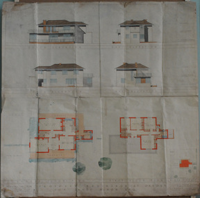
plans, July 1949
These house plans were drawn up for James Nixon. James Nixon was born in Orbost on 15.11.1912. He married Joyce May Thompson on 2.2.1937. He was a well known Orbost identity, serving a record 47 years as a Commissioner on the Snowy River improvement Trust, as well a director of Snowy River Seed and th Bean Board. He died on 21.12.2002.James Nixon, a third generation Nixon, father of Peter Nixon A.O., was an involved and respected Orbost identity. This item is a significant research tool.Architectural plans for a two-storey house with 4 bedrooms to be built on the corner of Gladstone and Tennyson Streets in Orbost. On a white background with coloured drawings ( water colour).nixon-james house-plans architecture -
 Orbost & District Historical Society
album, 1990's?
This album was used at the Orbost Visitor Information Centre (the Slab Hut). The Slab Hut (Orbost Visitor Information Centre) is an Orbost icon. This slab hut was built in 1872 as a family dwelling on a site about 3 km upstream from the junction of the Buchan and Snowy Rivers about 40 kms from Orbost on the Yalmy Rd. No nails were used in the construction; it was all wired together. After a period in storage the slab hut was opened in its present location in Orbost as the Information Centre in 1987.This item is a useful reference tool for the history of Orbost.A large photo album containing copies of photographs, some historical articles and b/w photos of Orbost. The covers are brown with a narrow gold frame. it has no spine and the covers are tied with tape. The pages, all different sizes, are bolted in.orbost-history album-photographs -
 Orbost & District Historical Society
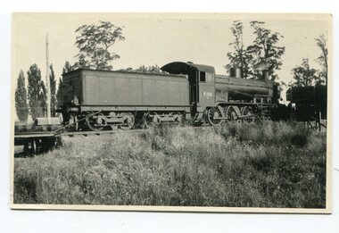
black and white photograph, Barkla, Ian R, 1925
This is a photograph of Steam Engine K104. K104 was numbered as such in 1923. Engines were renumbered from K100-K109 to K140-149 in 1940. This one was renumbered as K144. The Bairnsdale-Orbost railway was opened in 1916 to serve the agricultural and timber industry. Because of the decline in traffic and heavy operating costs, the line was finally closed in August, 1987.This is a pictorial record of rail transport in the 1920s. This item is associated with the history of the Orbost-Bairnsdale railway line and therefore reflects the role that the rail line played in the social and economic history of Orbost. On April 10 1916, the first scheduled train service left Orbost for Bairnsdale. The Bairnsdale-Orbost railway was opened to serve the agricultural and timber industry. Because of the decline in traffic and heavy operating costs, the line was finally closed in August, 1987.A black / white photograph of a steam locomotive. on back - "Orbost 1924 Steam Engine K104"orbost-railway steam-locomotive-k104 transport-rail -
 Orbost & District Historical Society
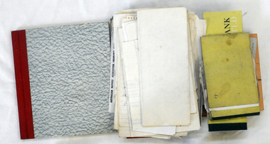
documents, 1950's -1970's
These documents were used by the Orbost Rifle Club.The Orbost Rifle Club existed in the early 20th century. (There are records from 1900). It folded in the late 1970's. It had a substantial membership.A large plastic envelope containing miscellaneous documents and books from the Orbost Rifle Club. Documents include receipts, cheque books, correspondence, cards, rules and an unused match record book.documents orbost-rifle-club match-records -
 Orbost & District Historical Society
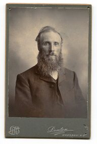
black and white photograph, Denton, Frank James, 1894 -1904
Reverend Alexander Morton was the Presbyterian minister in Orbost between 1894 and 1904. Rev. Alexander Morton earned great respect from the Orbost community, during his ministry here between 1894-1904. He brought with him from the New Hebrides timber which was used for the pulpit. Affectionately known as “Sandy” Morton, he was very friendly and endeavoured to reach all his bush parishioners, often on horseback. He was known up the Gelantipy Valley as an itinerant Preacher with a difference, he often doubled as a dentist, who was quite adept at pulling teeth, often with a pair of pliers. ( information from Margaret Smith Newsletter August 2012)Reverend Alexander Morton was a prominent Orbost citizen in the late 19th - early 20th centuries. He was associated with the Presbyterian Church in Orbost.A black / white portrait photograph on a dark grey buff card. It is a head and shoulders posed photograph of a bearded man in a suit.on back - Rev. Alex Morton, Presbyterian Minister at Orbost"morton-alexander presbyterian-church-orbost -
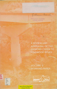 Eltham District Historical Society Inc
Book, A Review and Appraisal of the Diamond Creek to Ringwood Study, volume 2, working paper, by Loder and Bayly, 1979
... Loder and Bayly Planning and Engineering Consultants ...Volume 2: Working papers. This report is a review and appraisal of the Outer Ring Road Study Diamond Creek to Ringwood prepared for The Road Planning Liaison Committee by the Joint Road Planning Group for the The City of Doncaster & Templestowe and The Shire of Eltham by Loder & Bayly Planning & Engineering Consultants. "This paper attempts to set a framework for an evaluation of the recommended road link between Diamond Creek and Ringwood." Various perspectives are examined. Includes fold out maps.91 p, maps, 27 cm.melbourne ring road, roads, freeways -
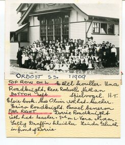 Orbost & District Historical Society
black and white photograph, 1909
This item is part of the Mary Gilbert Collection. Top Row on Left - Ethel Scouller; Una Roadknight; Rene Rodwell; Nathan Spielvogel (Head Teacher) Bottom Left - Elsie Cook; Miss Olivier with hat (teacher); Erica Roadknight, Penuel Cameron Far Right - Dorrie Roadknight;with hat (teacher); 3rd from left Vera Nixon; Sally Draffin behind her; Linda Gluth in front of Dorrie Tthe Orbost State School opened on19th of March 1886. The school had first operated temporarily in a leased building, and on a half-time basis with SS2745 Jarrahmond, The head teacher was Campbell Mackay who remained in charge only until 12th of May 1886. The second head teacher, John Rowe, served until 1908. On 30th of June 1887, a portable room was provided; it being brought to the area by schooner. The school now had accommodation for 30 pupils; the teacher's welfare was considered because quarters of two rooms were attached. As the population increased so did the needs of the school. This was reflected in the provision of a larger classroom in 1898. During 1910-11 the first approaches were made to the Department for the establishment of a Higher Elementary School in Orbost and this became a reality in 1912. Orbost. The Higher Elementary School supplied post-primary education in the district until a high school was built in 1948. When fire destroyed the school in 1941 local halls were used as classrooms until a new school was built, opened by the Hon. A. E. Lind, MLA, on 13th of February 1942. But Orbost continued to develop and the new school was soon overtaxed. This resulted in the erection of two Bristol classrooms in 1947. By 1950, when the school population had reached 500 pupils the opening of the new school at Orbost North was welcomed by all concerned. In 1963 the Department purchased land diagonally opposite the school and developed it as a playing area. This item is associated with education in Orbost.A black / white photograph with a list of names attached to the bottom. It shows a group of students and teachers in front of a wooden school building.on label - Orbost S.S. 1909 with a list of identifying nameseducation-orbost orbost-state-school -
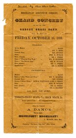 Orbost & District Historical Society
program, Snowy River Mail, 1891
This concert was held in the Mechanics' Institute on Friday, October 16th, 1891 commencing at 8pm. A dance was held after the concert. The secretary at that time was J. McNair. The first Orbost Brass Band was formed in 1889. Around 1908 the town band split and the Orbost Workers' Band was formed. Eventually the two bands merged in 1913 to reform as the Orbost Municipal Band under conductorship of Charles Spink. The band continued for many years but was later disbanded and again reformed. This was to happen a number of times, the last time being in 1961 and continuing through to the late 1970's. Further info and Ref: In Times Gone By - Deborah Hall From the estate of Elsie Cooke. Elsie Cooke was a librarian in Orbost for many years. She was the daughter of John Cooke early Brodribb settler. Elsie Cooke lived all her life in Gippsland,. She was born at Brodribb in 1895 and died in 1970, Elsie Cooke lived at Bruthen for a short time and, in 1937, moved to live with her aunt, Miss Jean Munro. Miss Cooke was Librarian at the Mechanics Institute for many years. Kindness and consideration for other were Miss Cooke’s attributes and she endeared herself to all who knew her. She was a loyal member of the Presbyterian Church and a stalwart of the Ladies’ Guild, an energetic worker for the Municipal Auxiliary and a member of the Red Cross. (ref. Mary Gilbert)The various Orbost bands over the years played a major role in community activities providing entertainment and musical experiences for the many members.An orange, paper program with black print. The program and details are inside a black frame. It is for a concert in aid of the Orbost Brass Band.At the top handwritten in black pen is" Donated by Mrs Elsie Cooke".orbost-brass-band-programme cooke-elsie