Showing 22329 items
matching parks
-
 Halls Gap & Grampians Historical Society
Document - Article (magazine/newspaper)
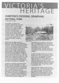
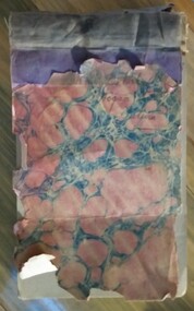
Article (3pages) written by David Catrice for Parks Victoria. More history on Walter Zumstein and the Zumstein area can be found on p137, 153 -156, 83, 107, 136 of "Victoria's Wonderland: a Grampians History"3page Article describes Walter Zumstein and the area known as 'Zumstein's'. Entitled Zumstein's Crossing, Grampians National Park from "Victoria's Heritage", Parks Victoria c1995media, magazine articles -
 Clunes Museum
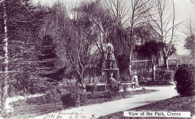
Photograph, QUEENS PARK, 1900 - 1910
.1 BLACK AND WHITE PHOTOGRAPH OF CLUNES QUEEN'S PARK. LADY SITTING ON FOUNTAIN EDGE. BUTTER FACTORY BRIDGE IN BACKGROUND. ELM TREES AND CYPRUS TREE AND PALM TREE PICTURED. .2.3 coloured enlarged copiesVIEW OF THE PARK, CLUNES. "SUNDAY" J.H.M. 6.2.10 SOH .1 about 1900-1905local history, queen's park garden -
 Surrey Hills Historical Society Collection
Photograph, Surrey Hills Station and car park
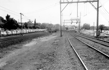
There are 3 tracks; the third track was built in 1971, which gives an approximate date for the photo. At this time the original station buildings were demolished and replaced by buildings constructed from concrete bricks and a second subway replaced the overhead footbridge. According to Roderick Smith, a local railway enthusiast, originally there had been 3 railway houses at the Mont Albert end of the northern car park. These were demolished to extend the car park. Certainly 8 Bedford Avenue, built as the station master's house was demolished at this time. The palm tree had been planted in the station master's front garden and was retained in a small garden bed within the car park. A black and white photograph of a station with cars parked on both sides of the 3 tracks. A Harris train is departing the station heading towards Mont Albert. A palm tree is prominent in the station car park to the north.1971, surrey hills station, railway stations, car parks, public transport, trains, railway lines, palm tree -
 Friends of Ballarat Botanical Gardens History Group
Work on paper - List of Trees Grown in Victoria Park. VPRS, Box 109. 5/1/1916. To the Town Clerk from the Hospital for the Insane, 21 Different Trees grown in Victoria Park in the early twentieth century, Unknown
Victoria Park featured in Ballarat's history from the nineteenth century.Victoria Park is a significant recreation area in Ballarat although the Ballarat Botanical Gardens and Lake Wendouree appear to have been seen as the pre-eminent garden areas over the years. 1 page with a list of names and numbers beside each. Reference at the bottom of the page.Written in black biro, beside the list, "List of Trees Grown in Victoria Park,1915.john garner, doctor john garner, ballarat botanical gardens, victoria park, friends of ballarat botanical gardens, trees, world war 2, american troops, john garner collection, gardens, ballarat -
 Kew Historical Society Inc
Photograph - Civic event in Stradbroke Park, 1976
Stradbroke Park. Extent: Kilby Road to Harp Road at Burke Road. Historical Documentation: 1851 - Portion 91 purchased by Edward Glynn; 1888 - The Harp of Erin Estate (which included Section 91) offered for sale; 1896 - The area now known as Stradbroke Park was bisected by a creek that flowed from the Yarra via Hay's Paddock (q.v.) and extended through to Burke Road; 1943 - W.D. Birrell, Town Clerk of Kew, proposed that the creek be filled and a reserve created; 1954 - Entire area designated as 'open space' and named 'Stradbroke Park'. The line of the creek that ran through the Park created a further reserve on the north side of High Street, now known as 'Harrison Reserve'. Existing Condition: The park is largely of mown grass that has mature trees set into it It is possible that a number of these are remnant of the original vegetation, while there are also a number of exotic trees introduced, particularly at the northern end of the park. The southern end is dominated by playing fields. (Source: Sanderson, P 1988. Kew Conservation Study)Colour photographic positive (with colour degradation) of sporting teams at a civic event in Stradbroke Park in Kew East in May 1976. The event was officiated by the Mayor of Kew, Cr Alan Hutchinson. Stradbroke Park is situated on the western boundary of Kew and bordered by Burke and Harp Roads.stradbroke park, cr alan hutchinson, team sports -- kew (vic.) -
Whitehorse Historical Society Inc.
Photograph - Illustration, Mary Ann Jeffery, n.d
Photocopy of portrait of Mary Ann Jeffery, 1853 - 1943Photocopy of portrait of Mary Ann Jeffery, 1853 - 1943 (from 'Sevenoaks Park' by R. de Costa)Photocopy of portrait of Mary Ann Jeffery, 1853 - 1943jefferey, mary ann -
 National Wool Museum
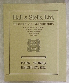
Book, Hall & Stells, Ltd, Makers of Machinery
"Hall & Stells, Ltd, Makers of Machinery, Park Works, Keighley, Eng", catalogue of machinery."Hall & Stells, Ltd, Makers of Machinery, Park Works, Keighley, Eng", catalogue of machinery.textile machinery, hall and stells limited -
 Marysville & District Historical Society
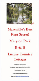
Flyer (item) - Information flyer, Marysville's Best Kept Secret! Maryton Park B&B Luxury Country Cottages, Unknown
An information flyer regarding Maryton Park B&B Country Cottages near Marysville.An information flyer regarding Maryton Park B&B Country Cottages near Marysville.marysville, victoria, australia, maryton park b&b country cottages, accommodation, information flyer -
 Marysville & District Historical Society
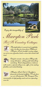
Flyer (item) - Information flyer, Maryton Park B&B Country Cottages, Unknown
An information flyer regarding Maryton Park B&B Country Cottages near Marysville.An information flyer regarding Maryton Park B&B Country Cottages near Marysville.marysville, victoria, australia, maryton park, maryton park b&b country cottages, accommodation, information flyer -
 Marysville & District Historical Society
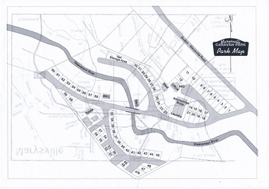
Map (Item) - Marysville Caravan Park map, Marysville CARAVAN PARK-Park Map, Unknown
A map of the Marysville Caravan Park showing the location of the various sites and facilities available to guests.A map of the Marysville Caravan Park showing the location of the various sites and facilities available to guests.marysville, victoria, australia, marysville caravan park, map -
 Melbourne Tram Museum
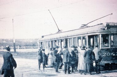
Slide - Black and white reproduction photograph - HTT Wattle Park line c1917
Photograph - HTT Wattle Park line c1917, bogie tram 20 loading many passengers. The tram is showing the destination of Wattle Park. Open fields in the background. Appears to be at least one solider waiting to board the tram.Yields information about the Wattle Park line and the trams used.Kodachrome cardboard duplicate slide - Black and white reproduction photograph - HTT Wattle Park line c1917 "MP8" in penciltrams, tramways, opening, htt, hawthorn tramways trust, wattle park, tram 20 -
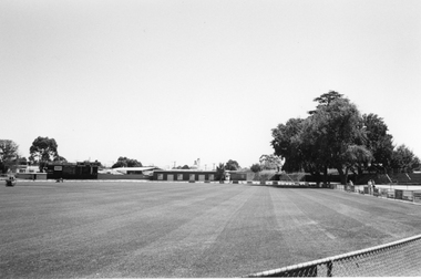 Stawell Historical Society Inc
Photograph, Central Park Oval looking towards scoreboard and athletic club rooms
Central Park looking towards scoreboard (left) and athletic club roomsCentral Park oval looking towards the scoreboard on the left and Athletic Club rooms. c 1999 -
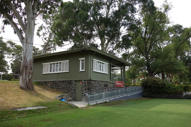 Kew Historical Society Inc
Photograph - Digital Photograph, Robert Baker, Kew Croquet Club, Victoria Park (Kew), 2014
The Kew Croquet Club rooms were designed by Roland Chipperfield. The Club was founded in 1934 and is located in Victoria Park, Kew.Born digital image of the exterior of the Kew Croquet Club in Victoria Park, Kew.kew croquet club - kew (vic), sports -- kew (vic.) -
 Melton City Libraries
Photograph, Dunvegan in early construction phase, 1978
Dunvegan was dismantled by work teams including local builder Ken Maclean who oversaw the materials to be transported to the Willows Park. The structure in its very early construction at the parks under Peter Bee stonemason.local architecture, local identities -
 Kew Historical Society Inc
Photograph - Flooding in the Willsmere Park, 1993
Willsmere Park is bounded by the the Yarra River, Green Acres Golf Club, Willow Grove and the Eastern Freeway. The land on which the park is now situated was bought by Thomas Wills at the Crown Land Sales of 1846 (Section 56). From the 1840s to the 1940s it was intensively farmed. The park is dominated by very large playing fields, while planting to the southern boundary was undertaken when the Eastern Freeway was built. It is only along the banks of the Yarra that there is any remnant native vegetation. Willsmere Park is of significance as an area of open land that remains from the flood plain that once dominated northern Kew. (Source: Kew Conservation Study, 1988)Original colour small format polaroid photograph of flooding in the Willsmere Park, taken on 16 September 1993."Flooding of shared path from Willsmere Billabong 16.9.93"willsmere park, yarra river -- floods -- kew (vic.), kew billabong -
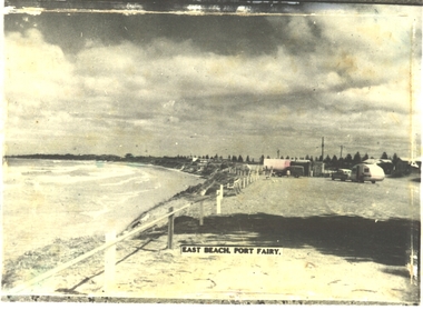 Port Fairy Historical Society Museum and Archives
Postcard - Photograph, East Beach, Port Fairy
East beach parking with half round shed for Life saving club and a teardrop caravan parkedBlack and white postcard of East Beach car park with tear drop caravan and carEast Beach port Fairyeast beach, parking, half round shed, teardrop, caravan -
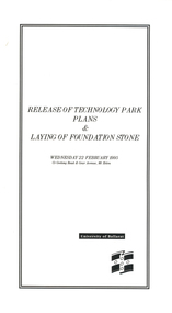 Federation University Historical Collection
Programme, Release of Technology Park Plans and Laying of Foundation Stone, 1995, 02/1995
The Ballarat Technology Park site consists of 28.8 hectares of freehold land zoned for technology Purposes. The development plan for the Park was prepared by the City of Ballarat. The construction of the ISSC Southern Regional Data Centre was the first stage of the project. ISSC Southern Regional Data centre is a $12.5 million building development at the corner of Geelong Road and gear Avenue. The building was constructed by H. Troon Pty Ltd. White card program for the Release of Technology Park Plans and Laying of Foundation Stone. ballarat technology park, issc southern region data centre, troon, david james, geoffrey blainey, bruce clark, john bligh, roger hallam, campus plan -
Bialik College
Mixed media (Item) - 2006 Wooranna Park PS
Wooranna Park PS June 2006 Jules film for UK Comp Video. Runtime 20.07. Please contact [email protected] to request access to this record. Wooranna Park PS June 2006 Jules film for UK Compprimary school, 2000s, 2006, united kingdom, bialik college, pedagogy -
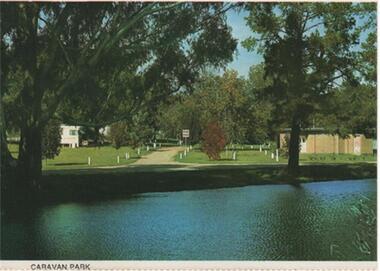 Rutherglen Historical Society
Post Card Folder, Big 7 Folder, Vue Pac. 7 Detachable Post Cards of Rutherglen Victoria, c1970
Donated by Mrs Brian Jasper.Coloured post cards in folder with views of Rutherglen and District. This one is a view of the Caravan Park taken from the far side of Lake King.On message side of card: "Rutherglen, Victoria. Looking across Lake King to the caravan park. | NCV.1052 Nucolorvue Productions Pty. Ltd."caravan park, lake king -
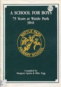 Surrey Hills Historical Society Collection
Book, A school for boys: 75 years at Wattle Park 3841, 1989
A history of the Wattle Park Primary School over 75 years. Compiled by Margaret Spratt and Mike TeggA brief history of the first 75 years of the Wattle Park Primary School. Includes photos. wattle park primary school, schools, (mr) raymond d. dennis, (mr) roger loveless, burwood boys' home, 1989, (miss) yvonne ritchie, (mrs) julia tooher, (mr) mike tegg, (mrs) lea mackay, (mr) nick farley, (miss) amanda broadhead, (mrs) barbara chapman, (mrs) shirley hogg, (mrs) eleanor kolbe-brown, (mrs) elaine shields, (mrs) joyce teele, (mr) jack barr, (ms) margaret spratt -
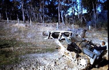 Wonga Park Community Cottage History Group
photograph, dam making, c 1940 for 1003 c1960 for 1003-1
Ernie Kear and his son Bruce were local excavators and involved in many projects around Wonga Park requiring bull dozing, in particular clearing land for orchards, building dams etcEarly history of Wonga Park orchard growing district. Early dams were built by horse and scoop on the back which was handled by the orchardist, or the dam builder but later replaced by bulldozersErnie Kear excavating a dam in Wonga Park c 1940 no hard copy electronic only -
Whitehorse Historical Society Inc.
Article, Job advertisements, 1977
Photocopy of a collection of advertisements for municipal councils.Photocopy of a collection of advertisements for municipal councils. Includes position of Assistant Superintendent of Parks and Gardens with the City of Nunawading.Photocopy of a collection of advertisements for municipal councils.city of nunawading, council staff, parks and reserves -
 Tatura Irrigation & Wartime Camps Museum
Book, Dr Park Prescription Book
Prescription book (pad) used by Dr A Park (medical doctor), at Tatura, in the 1895. Some of the book has been used Hard cover book with pink, blue and white patterned covering with taped spine. Opens at short edge. Inside pages have identical wording printed on each page and each page has been stamped with a number. Each page has another page underneath (copy) and made of thinner paper. Some of the pages have hand writing on them detailing what the prescription was for and to whom.On front cover but very hard to read: ???? Park, M B Hogan Taturadr a park, tatura doctors, prescription book -
 Orbost & District Historical Society
cutlery, 1880's
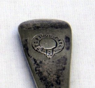
RIDGE PARK, Length: 65.2 m.; Owned by H. Simpson & Sons; Built at S. P. Austin & Sons in 1878. Registered at Adelaide. On 10 February 1881, RIDGE PARK (Capt. Heslop) was on voyage from Adelaide to Sydney with a cargo of brandy, wine and flour, when she was lost after running aground.Beware Reef is located south east of Cape Conran in east Gippsland.This cutlery is from the Ridge Park which, on 10 February 1881, was wrecked on Beware Reef , just south of Cape Conran in east Gippsland.Two forks and two spoon which are silver plated dinner cutlery.On front of handles - S.S.Ridge Park On back of handles - EP & NS with an A inside a circle -
 Melbourne Legacy
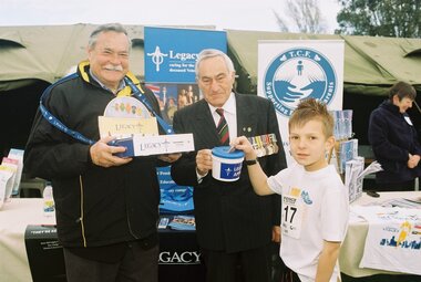
Photograph, Albert Park Fun Run, 2009
Legacy would be able to fundraise at the annual Fun Run at Albert Park Lake. Ron Barassi attended in 2009.A record that celebrities helped Legacy with fund raising.Photos taken at the Fun Run at Albert Park Lake in 2009, includes Ron Barassi.ron barassi, fundraising -
 Melbourne Legacy
Photograph, Albert Park Fun Run, 2009
Legacy would be able to fundraise at the annual Fun Run at Albert Park Lake. Ron Barassi attended in 2009.A record that celebrities helped Legacy with fund raising.Photos taken at the Fun Run at Albert Park Lake in 2009, includes Ron Barassi.ron barassi, fundraising -
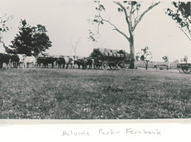 Lakes Entrance Historical Society
Photograph - Wool Wagon, Delvine Park sheep station Lindenow Victoria, 1890 c
Delvine Park was settled by Scott family in 1843Black and white photograph showing a large bullock team and driver with a loaded wool wagon preparing to leave Delvine Park sheep station Lindenow Victoria. Also a second black and white photograph taken of loaded wool wagon beside woolshed at Delvine Park which was the oldest in the area. transport, wool industry -
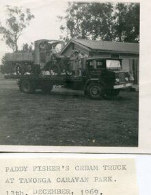 Kiewa Valley Historical Society
Photo - Paddy Fisher's Cream Truck 1969, December 13, 1969
The Hallford truck was made by J & E Hall, of Dartford, England, whose business commenced in 1785. In 1926 the Fisher family of Mongan's Bridge took delivery of the 1923 Hallford truck which was used on the farm to transport cream to the Kiewa Butter Factory in Tangambalanga. In 1967, the truck was sold to Mr Greg Bedstead and other members of the Kiewa Valley Historical Society for the KVHS who reimbursed them at a later date. The truck was housed at the Butter Factory for many years and was paraded on special occasions. The truck was purchased for $380. It's chassis no. 2439 and the price included a spare chain. (Ref. E. Fisher on 18th Dec. 1969) The KVHS group who paid $50 each towards the Hallford truck were: T Pyle; James Grave; P & E. Barton; K Shoebridge; K Plenderleith and SK Pearce.refunded in 1971 Hallford truck. Fisher family. Kiewa butter factory. J & E Hall Company of England. E FisherBlack and white photograph of Paddy Fisher's cream truck loaded onto a tray truck at the Tawonga Caravan Park. Seven unidentified people on the tray truckSmall typed note attached to back of photo 'Paddy Fisher's cream truck at Tawonga caravan park. 13th December, 1969hallford truck, cream truck, fisher family, kiewa valley farmers, mongan's bridge