Showing 11216 items matching "planning "
-
 University of Melbourne, Burnley Campus Archives
Plan, Burnley Gardens 1945, 1945
"Plan of School of Horticulture. Burnley Gardens 1945," handwritten on reverse. Also, photocopy of part of it, enlarged.Plan of School of Horticulture. Burnley Gardens 1945, handwritten on reverse.burnley gardens, burnley school of horticulture -
 Bendigo Historical Society Inc.
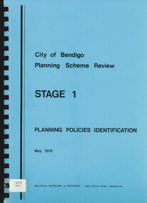
Book - CITY OF BENDIGO PLANNING SCHEME REVIEW STAGE 1, 1978
... Planning ...City of Bendigo Planning Scheme Review Stage 1. 101 pages, with maps.Meldrum Burrows & Partnersbendigo, planning, policies, bendigo, planning, planning scheme. -
 Clunes Museum
Document, TALBOT - CLUNES SHIRE, MUNICIPAL EMERGENCY MANAGEMENT PLAN - SHIRE OF TALBOT AND CLUNES (DRAFT)
THIS PLAN HAS BEEN PREPARED AT THE DIRECTION OF THE COUNCIL OF THE SHIRE OF TALBOT & CLUNES...DOCUMENTS COLLATED IN A GREEN PLASTIC BINDER WITH A CLEAR PLASTIC COVER (UNDATED)non-fictionTHIS PLAN HAS BEEN PREPARED AT THE DIRECTION OF THE COUNCIL OF THE SHIRE OF TALBOT & CLUNES...local history, government, local government, council, essential services -
Port Melbourne Historical & Preservation Society
Document - Specifications, Additions, Port Melbourne Town Hall, City of Port Melbourne, 8 Jun 1936
Specification for additions etc. to supper room at Town Hall, Port Melbourne, 1936 - included with plans, consisting of three typewritten foolscap pages of notes.Both notes and plan signed by F.C. Cook, City Engineer - 3rd page of notes, top left hand corner of plan.port melbourne town hall, city engineers, fred cook -
Stawell Historical Society Inc
Map, R.O. Robson - Authorised Surveyor, Road from Glenorchy to near Geary's Selection Callawaddy 1880, 29.04.1880
Survey for Road CreationCloth Backed Map. Plan of Road.Parishes of Richella & Callawadda. County of Borong. Plan of Road. R.O. Robson Authorised Surveyor Stawell 29.04.80 -
 Flagstaff Hill Maritime Museum and Village
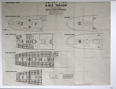
Plan - Ship Plan, Orient Steam Navigation Company, Orient Line, RMS Orion, ca. 1934
The Orient Steam Navigation Company Limited launched the Ocean Liner RMS Orion in 1934 and it remained in operation until 1963. The twin screw steamship was built to carry first class and tourist class passengers, over 1100 in all, plus almost 500 crew from Europe to Australia in comfort. The ship had a single funnel and a single mast. During WWII the vessel served as a troop carrier. The ventilation system noted on the plan, Punkah Louvre System, was designed for heating fresh air ventilation in buildings, ships and railroads. The system originated from Thermotank in Glasgow, Scotland. The ship plan for the RMS Orion is significant for its connection with the vessel. The ship was a leader, with several 'firsts'; the first Orient Line ship to be built with a single funnel since 1902, and the first to be painted in the Orient Line's livery, with a corn-coloured hull. It was the first liner to use chromium and bakelite materials for the surfaces throughout the ship, which provided greater resistance to the sea. It was also the first British ship to be fitted with air conditioning.Plan: printed provisional line drawing of the Orient line vessel "R.M.S. Orion". Inscriptions are printed on the plan. There are diagrams of six decks included in the plan. The ship is built for tourist "B" accommodation. The plan's Notices include details of the cabins including wardrobes, drawers, hinged seats, mattresses and bunk numbers. It also notes that there is a Punkah-Louvre System of Ventilation.Printed on the plan: "PROVISIONAL PLAN" "LOWER PROMENADE DECK" "UPPER CABIN DECK" "MAIN CABIN DECK" "LOWER CABIN DECK" "SUN DECK" "PROMENADE DECK" "ORIENT LINE / R.M.S. "ORION" / 24,000 TONS / TOURIST "B" CLASS ACCOMMODATION" "Owners: Orient Steam Navigation Company Limited"' "Managers : ANDERSON, GREEN & CO. LTD" "7 BISHOPS GATE, LONDON, E.C.2" "Chief Passenger Office : 14 Cockspur Street, London, S.W.1" "Branch Passenger Office : 1 Australia House, Strand, W.C.2" "notices"flagstaff hill, flagstaff hill maritime museum and village, warrnambool, maritime museum, maritime village, great ocean road, shipwreck coast, rms orion, plan, ship plan, provisional plan, orient line, orient ship, vissel orion, class b passenger accommodation, punkah louvre system of ventilation, deck plan, ship ventilation, ship floor plan, orient steam navigation company limited, anderson green & co ltd, steamship, ocean liner, war ship, troop carrier -
 Warrnambool and District Historical Society Inc.
Documents, WCC Proposed turntable site railway station, 1968; 1989
These two plans are copies and show drawings for a proposed turntable at the Warrnambool Railway Station and railway crossings at Gilles Street in the Liebig Street precinct. The Warrnambool Railway was opened in 1890 and the Warrnambool Railway Station building was erected a few years later. These plans, being copies, are of minor interest as they show plans of some projects in the Warrnambool Railway Station precinct in the latter half of the 20th century.These are two sheets of cream-coloured paper with plans (copies of original) drawn up in black ink. The drawings are fading somewhat and are faint in places. One sheet (.2) has a piece missing from the top left hand corner. .1 ‘Locality Plan of Rail Crossings Liebig St. & Gillies (sic) St.’ .2 ‘Proposed Turntable Site Warrnambool Railway Station’ plans, warrnambool railway, warrnambool rail turntable -
 Bendigo Historical Society Inc.
Map - FRED COWIE COLLECTION: AERIAL MAPS OF HEATHCOTE/EPPALOCK, 28-9-1960
Map, Heathcote C2, Township of Heathcote, Melbourne Road through town branching off to Bendigo & Echuca. Aerial Survey of Victoria. Photo-map prepared by Department of Crown Lands and Survey from photographs taken in 1960. Copied photographically at the Central Plan Office.Fred Cowie,46 McIvor Rd,Bgo..Central Plan Officemap, heathcote, fred cowie -
Creswick Campus Historical Collection - University of Melbourne
Document, unknown
School of Forestry existing services and condition plans, Building plans. Extension plansBuilding Plans -
 Bendigo Historical Society Inc.
Map - FRED COWIE COLLECTION: AERIAL MAPS OF HEATHCOTE/EPPALOCK, 28-9-60
Map, Heathcote C4, Aerial Survey of Victoria,Photo-map prepared by Department of Crown Lands and Survey from photographs taken in 1960. Copied photographically at the Central Plan Office.Date 28-9-60,C.P.O.Neg.No.21590.Scale 4 inches to 1 mile. Fred Cowie,46 McIvor Rd,Bgo..Central Plan Office.map, heathcote, fred cowie -
 Bendigo Historical Society Inc.
Map - FRED COWIE COLLECTION: AERIAL MAPS OF HEATHCOTE/EPPALOCK, 28-9-60
Map, Heathcote C3, Aerial Survey of Victoria, Photo-map prepared by Department of Crown Lands and Survey from photographs taken in 1960.Copied photographically at the Central Plan Office. Date 28-9 60, C.P.O.Neg. No.21588.Campaspe River, Coliban River. Flower Hill. Fred Cowie,46 McIvor Rd.Bendigo (Not located 29.9.2022)Central Plan Office.map, heathcote, fred cowie -
 Federation University Historical Collection
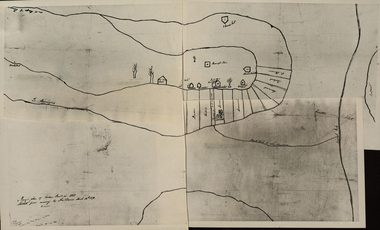
Photograph - Black and White Photograph, Rough Plan of Golden Point in 1851
A photograph compilation of a Rough Plan of Golden Point in 1851. "Rough Plan of Golden Point in 1851. sketched from memory by Thos Dunn March 16th 1870." golden point, ballarat, thomas dunn, cavanagh's claim, bickett's party, o'connor, hammond, greenwood, gold discovery -
 Falls Creek Historical Society
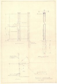
Plan - Diagram of Turnstile for New Chairlift
Bob (Herman) Hymans (a former member of the Royal Netherlands Navy was born in Bloemendaal, Holland on 30th September 1922. During World War II he fought against the Japanese in the Dutch East Indies (now Indonesia) and was imprisoned in Changi and on the Burma Railway. After gaining qualifications as a Ski Instructor, Bob arrived in Falls Creek in May 1950. Working as an Instructor and Supervisor at Bogong Lodge, Bob decided his future was in accommodation. He was successful in negotiating an indenture for land from the State Electricity Commission (SEC). It took Bob two years to build his Grande Coeur Chalet but, tragically, it was burned down in August 1961. Bob also built the first Chairlift in Australia. This was a single chairlift and the structure was built from wooden electricity poles. He was constantly full of new ideas and proposals for the village. Bob Hymans died on 7th May 2007. This Collection of documents and letters tells the story of Bob’s endeavours to develop Falls Creek into the ski village it is today. This map is significant because it documents plans made by Bob Hymans for Falls CreekThis diagram is part of Bob Hymans documents. It is a detailed plan, including elevation, detail of pivot and the general arrangement views of a turnstile. This is part of overall plans for the construction of a new chairlift at Falls Creek. At bottom of diagrams: PLAN TURNSTILE/ GENERAL ARRANGEMENT Scale 1 1/2" = 1'- 0"map of falls creek, falls creek leases, falls creek 1980s -
 Greensborough Historical Society
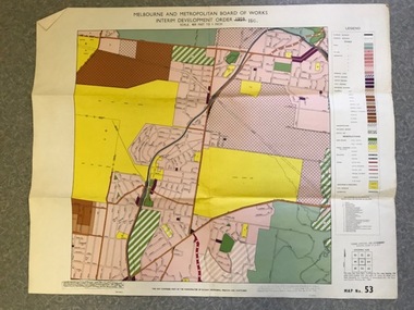
Map, Melbourne and Metropolitan Board of Works Interim Development Order 1961 Map No. 53, 27/09/1961
Denotes Zones and Reservations comprising part of the municipalities of Eltham, Heidelberg, Preston and Whittlesea, approved 27.9.61. Includes Mont Park Hospital and Watsonia Military Camp.Colour plan Date printed on plan (1959) has been over stamped with 1961. Also stamped with Government Gazette date of 27.9.1961. "Scale 800 feet to 1 inch"greensborough, watsonia -
![Planning Document, Plan of proposed subdivision of land in Greensborough [Map shows Scotland house], 01/04/1971](/media/collectors/4f729f5697f83e03086015b8/items/5982a68921ea6b1420e4e560/item-media/59916fb521ea681094908d7a/item-fit-380x285.jpg) Greensborough Historical Society
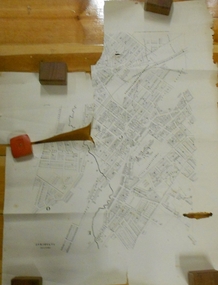
Greensborough Historical SocietyPlanning Document, Plan of proposed subdivision of land in Greensborough [Map shows Scotland house], 01/04/1971
This subdivision of Greensborough shows the home of John Scotland (died 1888) and surrounding area bounded by Hailes, William, Lorimer, and Jessop Streets.Photocopy of plan, 2 pages.Part of plan (68G) of proposed subdivision of Greensborough, part of Crown Portion 18, Parish pf Keelbundora. Scale: 132 ft. to an inchjohn scotland, hailes street greensborough, william street greensborough, lorimer street greensborough, jessop street greensborough -
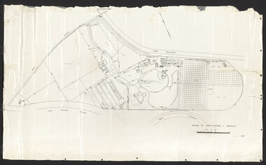
 Bendigo Historical Society Inc.
Document - MARKS COLLECTION: PLAN OF SANDHURST CITY CENTRE AND SURROUNDING AREA ( NO. 1 )
... Planning ...Plan on heavy parchment - section neatly cut out of area now Kennington. Written on plan in black print ' Sheet No. 1. Sandhurst'. Plan shows Government Camp, Commissioner's Gully, old cemetery site, manure depot, cattle market, Benevolent Asylum Reserve, railway reserve. Landowners' names on allotments. On bottom lithographed at the Department of Lands and Survey, Melbourne, by D. Henerson, March 12th., 1867 Plan part of George Lansell, Fortuna auction, documents found in wardrobe purchased by Marks family in 1930's.bendigo, planning, sandhurst 1867 -
Ringwood and District Historical Society
Envelope, Jean Gordon Government Printer - Melbourne, Ringwood Primary School: Documents re Proposed school rooms, Canteen and Library plans, electrical plans. 1969-1973, 1969-1973
School PlansRingwood Primary School Documents:; 1969 Proposed school rooms - Plans.; No Date - Canteen Plans.; 1973 Library - Plans.; No Date - Electrical Plans. +Additional Keywords: Gordon, Jean -
 Ringwood and District Historical Society
Newspaper, Scrapbook Clipping, Library Collection, Ringwood, Victoria
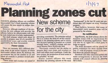
Newspaper Clipping from "The Maroondah Post", 1/7/1997. Planning zones cutCouncil planning officers are confident Maroondah City's draft planning scheme will ensure the area retains its unique characteristics. The council officers believe its effectiveness will only be truly tested once it is fully implemented. -
 Federation University Historical Collection
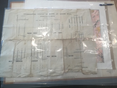
Plan, Underground Survey of Mines at Spring Hill - Sections
This plan is associated with former Ballarat School of Mines Student Richard Squire (1875-1876). Printed (in black ink) sections of underground mines on cream paper. 120 feet to one inch scale.Numbers written in pencil along bottom of plan. madam berry, lord harry, berry consols, west loughlin, loughlin, west ristori, ristori, mining, gold mining, gold, underground survey -
 Ringwood and District Historical Society
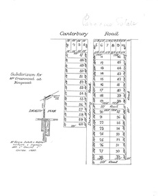
Plan, Paradise Estate Subdivision, Ringwood, Victoria - circa 1925
Paradise Estate layout also included in Land Sale Brochure Titled Eureka Plan Book - Seven Delightful & Valuable Ringwood Estates - circa 1925, Reg. No. 5100.Subdivision plan of Paradise Estate, Ringwood, showing allotments for sale, with typed page attached showing block sizes and prices.Locality plan showing land for sale south of Canterbury Road, 1 Mile south of Ringwood Railway Station. Subdivison includes Canterbury Road and Dandenong Road (later Wantirna Road). Surveyors - McKenzie Aisbett & Webber, surveyors & engineers, 440 Little Collins Street, Melbourne, Telephone Central 11540. Subdivision for Mr Grenwood at Ringwood. Additional typewritten price list showing footage, price per foot, and price per block for Lots No. 1 to 60. Paradise Estate layout also included in Land Sale Brochure Titled Eureka Plan Book - Seven Delightful & Valuable Ringwood Estates - circa 1925, Reg. No. 5100. -
 University of Melbourne, Burnley Campus Archives
Plan, Plan of Richmond Park, 1886-1948
(1) Black and white photographed copy of an original coloured plan. Plan of Richmond Park with Horticultural Society Gardens marked in. Includes additional land which became the Field Station. Original plan dated 31 August 1872, note of Crown Grant to the Board of Land & Works and Richmond City Council 1886; showing land, "Permanently Preserved for the Gardens". Stamp, "Department of Lands and Survey Photographed at the Central Plan Office 1/1 Plate 7.12.48" (2) Also 2 photocopies, 1 reduced - possibly used in a publication1 photocopy has "Figure 1. Plan of Burnley Gardens circa 1863 [sic]gardens, richmond, horticultural society of victoria, richmond park, a.l. martin -
 Orbost & District Historical Society
folder of documents, 1992-1993
Orbost Aero Club began in 1969 with Basil Dowie as Chair, David Nixon as Secretary/Treasurer. The group went into recess from 1977-1991 closing in 1997. The mid 1960s were boom years in flying training in Australia and the number of Aero Clubs grew rapidly. The Club played a significant role in the establishment of the small airport at Marlo and in the ongoing operation and development of the airport over the years particularly for patient transfer by aerial ambulance. The Orbost Aero Club Club played a significant role in the establishment of the small airport at Marlo and in the ongoing operation and development of the airport over the years.A manila folder containing plans and approvals for the airport terminal building at Marlo Airport. On a label on front - AIRPORT TERMINAL BUILDING 1992/1993 plans & approval ORBOST AERO CLUBorbost-aero- club marlo-airport -
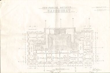 Bendigo Historical Society Inc.
Plan - NEW PUBLIC OFFICES SANDHURST
... Planning ...Photocopy of Plan for New Public Offices Sandhurst 1883-1887 - Drawing No3/Contract No2bendigo, planning, sandhurst -
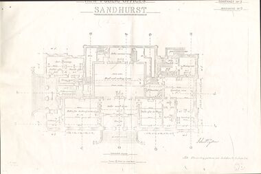 Bendigo Historical Society Inc.
Document - NEW PUBLIC OFFICES SANDHURST
... Planning ...Photocopy of Plan for New Public Offices Sandhurst 1883-1887 - Drawing No2/Contract No2bendigo, planning, sandhurst -
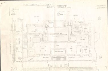 Bendigo Historical Society Inc.
Document - NEW PUBLIC OFFICES SANDHURST
... Planning ...Photocopy of Plan for New Public offices Sandhurst 1883-1887 - Drawing No1/Contract No2bendigo, planning, sandhurst -
 Bacchus Marsh & District Historical Society
Map, Limestone Reserve Parish of Merrimu 1888
Limestone deposits in the Coimadai area 10 kilometers north of Ballarat were first worked in the 1850s. The area was quarried for limestone for many years by various people and companies. The surveyor's name who produced this plan is inscribed on the map and below this is the name P. L. Alkemade, who presumably paid for the map to be produced. In 1886 Petrus Alkemade in partnership with Matthew Egan established the Alkemade Hydraulic Lime and Cement Company. The Alkemade family were involved in the limestone industry over several generations at Coimadai.Single page map showing part of the Limestone reserve near Coimadai in the Parish of Merrimu. Scale 4 chains to 1 inch. Part of a set of maps which are pasted into a bound volume containing 76 maps or plans in total. High resolution digital image stored on BMDHS computer network. Copy of plan surveyed by Mr. G? [illegible] an authorised surveyor on 17th July 1888. P. L. Alkemadebacchus marsh victoria maps, lime kilns coimadai, limestone, coimadai victoria maps, alkemade family coimadai -
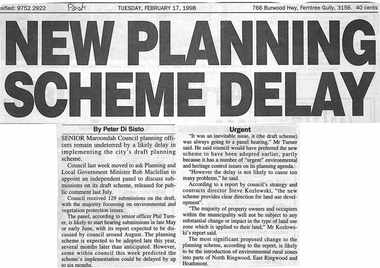 Ringwood and District Historical Society
Newspaper, Scrapbook Clipping, Library Collection, Ringwood, Victoria, `
``Newspaper clipping from the "Post", Tuesday February 17, 1998. NEW PLANNING SCHEME DELAY. By Peter Di SistoSenior Maroondah Council planning officers remain undeterred.by a likely delay in implementing the city's draft planning scheme. Council last week moved to ask Planning and Local Government Minister Rob Maclellan to appoint an independent panel to discuss submissions on its draft scheme, released for public comment last July. ` -
Federation University Historical Collection
Plans, Plans of the Wimmera College of TAFE, 1983, 18/05/1983
The plans were prepared by the Public Works Department VictoriaBook of plans relating to the Wimmera College of TAFE. The book includes developed sketch plans, site plans and landscape plans for the Horsham Technical School site and Langerenong Agricultural Collegewimmera, horsham, wimmera college of tafe, horsham technical school, longerenong, longerenong agricultural college, p. martin, j.t. green -
Stawell Historical Society Inc
Map, Shire of Stawell, Shire of Stawell Interim development Order, C 1930
Planning MapColoured Map of Stawell Shire showing Zoning AreasGuttering Haskings & Davey Pty Ltd Division of Urban and Environmental Planninglocal development -
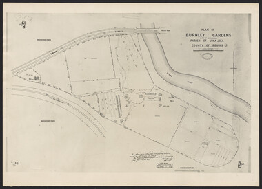 University of Melbourne, Burnley Campus Archives
Photograph - Plan of Burnley Gardens
"This plan is a copy of a copy of the survey made by Mr. Turner in 1926. The original plan and field notes are missing _ file Rs 3529" Signed by _signature unreadable_