Showing 2264 items matching "proposed"
-
 Port Melbourne Historical & Preservation Society
Plan - Heath Street, Port Melbourne, Borough of Sandridge, Mar 1864
Plan of longitudinal and cross sections of proposed works in Heath Street.M. Tierney:Denis Sullivan:Thos. P. Warren:Geo. Kelly (Borough Surveyor)engineering - roads streets lanes and footpaths, m tierney, denis sullivan, thomas p warren, george kelly -
Port Melbourne Historical & Preservation Society
Flyer - PMHPS, proposed meeting dates, 1993
Flyer with list of proposed PMH&PS meeting dates, 1994societies clubs unions and other organisations, port melbourne historical & preservation society, pmhps -
Port Melbourne Historical & Preservation Society
Plan - Proposed footbridge over the Lagoon, Bridge Street, Port Melbourne, 1863
Plan of proposed footbridge over the Lagoon in line of Bridge StreetIn ink on reverse, two small drawings: elevation land view over a distance of 25.00 chains (colour tinted), and Plan view, section of an unidentified street:In pencil on reverse, notation '107 Albert Street'sandridge lagoon, robert h morgan -
Clunes Museum
Plan - ARCHITECTS PLANS, KEVYN JOY ARCHITECTS, 12 JUNE 2009
PROPOSED CLUNES NEIGHBOURHOOD HOUSE PLAN TEMPLETON STREET 2009clunes neighbourhood house, proposed plans, templeton street -
Stawell Historical Society Inc
Realia - Calender, Brambuk Visitor Centre, A Year in Grampians - Gariwerd
Perpetual Calender. With eight proposed seasons according to Indigenous AustraliansOn a backgrous of Blurred of white and red Flowers "A Year in the Grampians Gariwerd". A Photo of the Grampians across farmland "This Calender combines Australian and European traditions" "Indigenous Australians observe changing weather and environmental patterns and resulting cycles of local seasons. On Each page of this calendar the large scene photos were taken in that month, over a period of twenty years. ( It must be remembered that flowers vary with the elevation, the soil, the aspect and the weather from year to year. You will not always find the same flowers in the same month as portrayed here.) In Europe, a calendar in the home is a long tradition: be it the familiar annual version or the Perpetual one to record important recurring dates such as family birthdays. It is our hope that however you choose to use our calendar, you will take peasure in the colour and beaty of the year in the Grampians Gariwerd." "All photographs by kees and Margo Sietsma. All Profits from the sale of this Calendar go to the Community Association of Halls Gap for the upkeep of our Botanical Gardens of Grampians flora. Dedicated to the memory of Kees Sietsma. with thanks to God, creator and Sustainer. -
 National Wool Museum
Drawing
Proposed treatment from the Conservation Centre, 7 March 2002 -
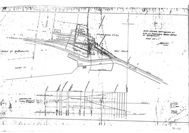 Queenscliffe Maritime Museum
Plan - Proposed buoy depot at Queenscliffe 14/9/1926, Government Works plan of buoy depot proposal, 1926
Queenscliffe buoy depot locationHistorical details of proposed buoy depotphotocopy of a plan showing proposed buoy depot location 1926Reverse " NIL ".historical references -
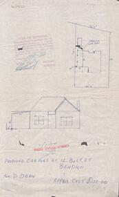 Bendigo Historical Society Inc.
Document - DOCUMENT. PROPOSED CAR PORT, 1974
Document. Plans for Proposed Car Port. 12 Bolt Street. -
Canterbury History Group
Document - Plans of the proposed toilets at Canterbury Bowling Club, 1964
Plans of the proposed additional toilets at Canterbury Bowling Club roomscanterbury, canterbury bowling club, kendall street, plans, toilets, lawn bowls -
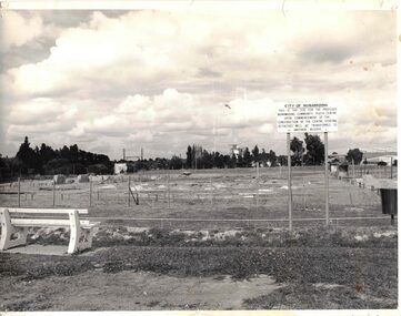 Whitehorse Historical Society Inc.
Photograph - Black & white photograph/s, Nunawading Community Youth Centre
Proposed land for the new Nunawading Community Youth Centre in 1980.nunawading, youth centre, 1980 -
University of Melbourne, Burnley Campus Archives
Plan - Photocopy, Burnley Site, c.1970s
Part B. Photocopy of plan of site with proposed changes marked on it.buildings, burnley gardens -
 Rutherglen Historical Society
Microfiche, Corporation of the President of the of Jesus Christ of Latter Day Saints, Family Register Index, 1987
Identity the families registered with the Church of Jesus Christ of Latter Day Saintssmall sheet of film Alphabetical Index NADELHOFFER - (PROPOSED SURNAME ORG) Church of Jesus Christ of Latter Day Saintsfamily, register, alphabetical -
 Rutherglen Historical Society
Microfiche, Corporation of the President of the of Jesus Christ of Latter Day Saints, Family Register Index, 1987
Identity the families registered with the Church of Jesus Christ of Latter Day Saintssmall sheet of film Alphabetical Index PHTLP - (PROPOSED SURNAME ORG) Church of Jesus Christ of Latter Day Saintsfamily, register, alphabetical -
 Rutherglen Historical Society
Microfiche, Corporation of the President of the of Jesus Christ of Latter Day Saints, Family Register Index, 1987
Identity the families registered with the Church of Jesus Christ of Latter Day Saintssmall sheet of film Alphabetical Index STALLSWORTH - (PROPOSED SURNAME ORG) Church of Jesus Christ of Latter Day Saintsfamily, register, alphabetical -
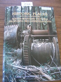 Stawell Historical Society Inc
Book, Land Conservation Council, Historic Places Special Investigation South Western Victoria Final Recommendations, 1997
Card Cover with color Photo of Double drum winch at a sawmill mill site Green SpineHistoric Places Special Investigation South-Western Victoria Proposed Recommendations Land Conservation Councilstawell heritage -
 Ringwood and District Historical Society
Map, Plan of Subdivision - State School Estate, Ringwood East, Victoria - (Undated, circa 1920s)
Map of land for sale attached to green cardboard backing with handwritten notations showing numbered allotments on Dublin Road, Holland Road, King Street, Charles Street and Purser Avenue, Ringwood East.Locality plan includes reference to proposed Ringwood East railway station which opened in 1925. -
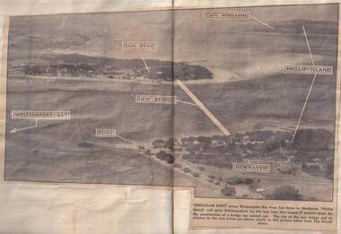 Phillip Island and District Historical Society Inc.
Newspaper clippings
Aerial photograph in newspaperAerial photograph of site of proposed bridge between San Remo and Newhaven.local history, documents, newspapers, bridges, phillip island, black & white newspaper clipping, phillip island. -
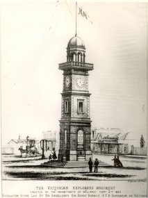 Federation University Historical Collection
Image, Victorian Explorers Monument, Ballarat
Image of a proposed Victorian Explorers Monument for Ballarat which was never built. victorian explorers monument, herman deutsch, burke and wills, gray, becker, ballarat -
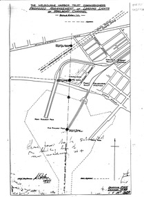 Port Melbourne Historical & Preservation Society
Map, Leading Lights of Port Melbourne Channel, 1926
Proposed arrangement of Leading Lights of mailboat channel at Port Melbourne piersbeacons, melbourne harbor trust - port of melbourne authority, leading lights -
Port Melbourne Historical & Preservation Society
Plan - Proposed crossing, Rouse Street at Nott Street, George Kelly, Borough Surveyor, 27 Oct 1864
Place of Proposed Crossing in Rouse Street (Corner Nott Street) PlanGeo. Kelly, Cr.(?), Borough Surveyor, Sandridge, 27-10-1864engineering - roads streets lanes and footpaths, george kelly -
Port Melbourne Historical & Preservation Society
Plan - Proposed railway along Howe Parade to Webb Dock, 1973
Plan of proposed railway along Howe Parade to Webb Dock 1973R.C.B. drawing no 7931piers and wharves - webb dock, perce mcguire white, perce white -
Port Melbourne Historical & Preservation Society
Document - Report, Bay Street project, May 1998
Produced by the City of Port PhillipBay Street project report. Background report for proposed improvement 1998town planning, city of port phillip, bay street -
Port Melbourne Historical & Preservation Society
Pamphlet - Proposing West Gate Bridge, The Lower Yarra Bridge, 1968
Found in Lois Daley's father's technical manual''The Lower Yarra Bridge': brochure proposing West Gate Bridge, 1968engineering - bridges, west gate bridge, lower yarra crossing authority -
University of Melbourne, Burnley Campus Archives
Document, Diploma course, 1946-1949
Notes on proposed Diploma course; Dookie Agricultural College Prospectus 1946dookie agricultural college, diploma course -
Whitehorse Historical Society Inc.
Article, Places For Kinder Kids In Jeopardy, 1993
State Government has proposed to merge kindergartens with child care centres.State Government has proposed to merge kindergartens with child care centres.State Government has proposed to merge kindergartens with child care centres.child care, fahey, vikki, benwerrin preschool, burwood east, hickey, sue, john, michael -
Whitehorse Historical Society Inc.
Document, City of Whitehorse Arts and Cultural Strategy, 1/10/2003 12:00:00 AM
Outlines current status and proposed plans for artistic and cultural activities in the city.Outlines current status and proposed plans for artistic and cultural activities in the city.Outlines current status and proposed plans for artistic and cultural activities in the city.city of whitehorse, whitehorse centre, box hill community arts centre, schwerkolt cottage & museum complex -
Whitehorse Historical Society Inc.
Article, City of Nunawading, 1994
Notice given that the Council of the City of Nunawading has prepared a proposed budget.Notice given that the Council of the City of Nunawading has prepared a proposed budget.Notice given that the Council of the City of Nunawading has prepared a proposed budget.city of nunawading, local government, local government finance -
Whitehorse Historical Society Inc.
Article, Industry finds no welcome, 1989
Protest against the proposed subdivision of part of Wunderlich Tiles property in Vermont.Protest against the proposed subdivision of part of Wunderlich Tiles property in Vermont.Protest against the proposed subdivision of part of Wunderlich Tiles property in Vermont.land subdivision, mitcham road, vermont, rooks road, vermont, wunderlich limited -
 Queenscliffe Maritime Museum
Plan - Proposed option for housing for the QUEENSCLIFFE, Vacant Council Depot at Queenscliffe, unknown
Queenscliffe lifeboat housing optionOption to house the QUEENSCLIFFEPlan of vacant council depot proposed to house the QUEENSCLIFFE in 2-partsReverse - " nil ".historical references -
Canterbury History Group
Map - Maling Road Urban Renewal Map 1972, 1972
Photocopy of map of proposed urban renewal in Maling Road Canterbury 1971canterbury, maling road, town planning, maps