Showing 2156 items matching "reefs"
-
 Stawell Historical Society Inc
Map, Underground Survey of the Principal Mines of Stawell 1879, 1879
Pleasant Creek & Newington, Prince Patrick, Prince Alfred, Pioneer and Galatea, Pleasant Creek Cross Reef No. 1&2, Magdala, Old Shaft, Extended Cross Reef, Crown Cross, Great Northern, Sloanes & Scotchmans, South Cross, 10 & 11 United Scotchmans South Cross, Scotchmans Shafts, North Scothmans, West Scotchmans, Emerald Isle & Rose of Denmark, Albion, South Scotchmans, Newington & Pleasant Creek, Pleasant Creek Cross Reef, Moonlight, Extended Cross Reef, Crown cross United, Great Northern ShaftVery large Map on cloth backing, showing cross sections of mines.Surveyed by H.C. Bates. Drawn by Arthur Edwards. October 30th 1879. Scales 120 feet to an inchmining, gold -
 Bendigo Historical Society Inc.
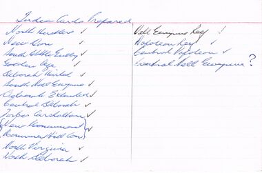
Document - SET OF INDEX CARDS - MINING
Set of Index Cards prepared (white lined) containing information on various mines - North Hustlers, New Don, South Wattle Gully, Golden Age, Deborah United, South Nell Gwynne, Deborah Extended, Central Deborah, Forbes Carshalton, New Monument, Monument Hill Consolidated, North Virginia, North Deborah, Nell Gwynne Reef, Napoleon Reef, Central Napoleon, Central Nell Gwynne. McColl, Rankin & Stanistreet Collection.topic, mining, companies -
 Bendigo Historical Society Inc.
Map - OLD TOM MINE, WHIPSTICK
2 copies ( A4 and A3) of Old Tom lease. Map shows Old Tom Reef, old working open cutting, shaft 150 ft., Easter Reef, dam sand heap, water race, 3 other shafts, 120ft., 90ft., and 500 ft. marked on map. Stamped on map '64.3.34' Written on bottom of map in handwriting ' Old Tom Lease, Parish of Huntly, County of Bendigo, Mining district of Sandhurst'bendigo, mining, old tom lease map -
 Bendigo Historical Society Inc.
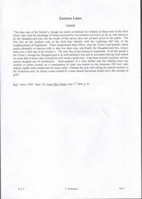
Document - TYSON'S LINE - EASTERN LINES
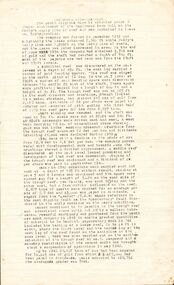
BHS CollectionTyped carbon copy and typed copy of General notes on the lines East of the Hustlers. Lines mentioned are: Hustler's, New Chum, Lightning Hill, Tysons, Slaughteryard, Isabella Mine, Ironstone Hill Reef, Nicholson Reef, on which a mine owned by a man named Stevenson mined a fair amount of gold. Ref. Anon; 1899. Spec. Ed. Aust. Min. Stand. June 1st 1899: p 61. Notes prepared by Albert Richardson.mining, parish map, tyson's line, eastern lines, hustler's, new chum, slaughteryard line, lightning hill, tyson's, isabella mine, ironstone hill reef, nicholson reef, mr stevenson, aust min stand 1 june 1899 -
 Bendigo Historical Society Inc.
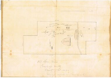
Document - UNDERGROUND SURVEY OF BENDIGO MINES
Two page document, 'Underground survey of Bendigo, report on Constellation Company's Mine on northern extension of the Garden Gully line of reef. Report on the New Chum Railway Reserve Company and the Shenandoah Company, the New Chum Railway Co being immediately south and the Shenandoah Co immediately north of the railway line. Two maps Constellation Co. Mine shaft and New Chum Railway and Shenandoah auriferous reef below 2700 feet.Jems Stirling, geologist and W.H Cundy Underground Surveyor, Department of Minesbendigo, mining, garden gully line of reef mines -
 Bendigo Historical Society Inc.
Document - THE SOUTH VIRGINIA MINE - HISTORY
One page and a half of typed notes on the history of the South Virginia Mine on the Paddy's Gully line of reef. Contained in Lease No. 10934, Bendigo. Company formed in 1932 and closed down in 1950.document, gold, south virginia mine, the south virginia mine - history, the leader, south new moon company, mining journals 1939 - 1950, bendigo goldfield 1936, ken bice -
 Bendigo Historical Society Inc.
Document - ANCIENT ORDER OF FORESTERS NO. 3770 COLLECTION: CORRESPONDENCE
Letter from William Thomas Mason of Victoria Reef Happy Valley claiming the Sick Allowance of the Court being unable to attend his usual employment. Dated Aug 22 1863.societies, aof, correspondence, ancient order of foresters no. 3770 collection - correspondence, court king of the forest, william thomas mason -
 Bendigo Historical Society Inc.
Document - ANCIENT ORDER OF FORESTERS NO 3770 COLLECTION: MEDICAL CERTIFICATE
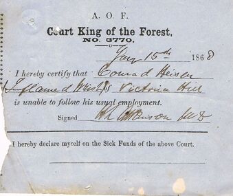
Blue paper dated Jan 15th 1868. I hereby certify that Conrad Heiser of Victoria Reef is unable to follow his usual employment. Signed H. L. Atkinson. M.D.societies, aof, correspondence, ancient order of foresters no 3770 collection - medical certificate, court king of the forest, conrad heiser, h l atkinson -
 Bendigo Historical Society Inc.
Document - ANCIENT ORDER OF FORESTERS NO 3770 COLLECTION: MEDICAL CERTIFICATE
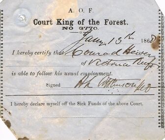
Blue paper dated Jan 13th 1868. I hereby certify that Conrad Heiser of Victoria Reef is able to follow his usual employment. Signed H. L. Atkinson. M.D.societies, aof, correspondence, ancient order of foresters no 3770 collection - medical certificate, court king of the forest, conrad heiser, h l atkinson -
 Bendigo Historical Society Inc.
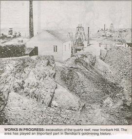
Newspaper - JENNY FOLEY COLLECTION: WORKS IN PROGRESS
Bendigo Advertiser "the way we were" from 1999. Works in progress: excavation of the quartz reef, near Ironbark Hill. The area has played an important part in Bendigo's goldmining history.newspaper, bendigo advertiser, the way we were -
 Bendigo Historical Society Inc.
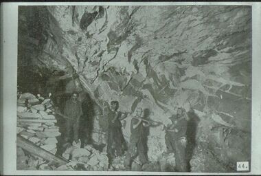
Slide - ALBERT RICHARDSON COLLECTION: BORING ON A REEF
Slide. Bendigo Mines-Jack Hattam Collection. Workers boring on a reef, underground at Catherine United Mine but could be New Moon. Image sourced from ' Healthy Golden Bendigo' book.No. 44 printed on bottom of slidemine, gold, catherine united, underground., bendigo mines-jack hattam collection. -
 Bendigo Historical Society Inc.
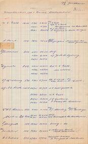
Document - MCCOLL, RANKIN AND STANISTREET COLLECTION: NAPOLEON REEF, 13th October, 1954
Four red and blue lined cashbook pages, Foolscap size, referring to the Napoleon Reef Gold Mining Company NL for uncollected 1st and final distribution of 7½ d. per share.gold, mining, share distritution, bendigo, gold mining, napoleon reef gold mining company. -
 Bendigo Historical Society Inc.
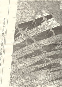
Map - LONG GULLY HISTORY GROUP COLLECTION: BENDIGO GOLD FIELD - GOLDEN SQUARE GEOLOGICAL SURVEY OF VICTORIA
BHS CollectionPart of a map of the Bendigo Gold Field - Golden Square. Geological Survey of Victoria. Shown are reefs, faults and anticlines. Many of the mines are shown on the map. Gullies, hills and streets are also shown.bendigo, history, long gully history group, the long gully history group - bendigo gold field - golden square geological survey of victoria, north bendigo state school reserve, hospital reserve, benevolent asylum reserve, empire hill, richmond hill, raes hill, south end hill, victoria hill, new chum hill, iron bark hill, redan hill, view hill, hustlers hill, camp hill -
 Bendigo Historical Society Inc.
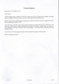
Document - VICTORIA QUARTZ - BRIEF NOTES ON THE VICTORIA QUARTZ MINE
Handwritten notes on the Victoria Quartz Mine. Notes mention locality, depth, geological information, Dividends, Calls and the Victoria Reef Tribute. Document from Albert Richardson Collection of mining history.document, gold, victoria quartz, victoria quartz, brief notes on the victoria quartz mine, victoria reef quartz shaft no 127, vict reef q m coy, mines dept, bendigo advertiser, victoria reef tribute -
 Bendigo Historical Society Inc.
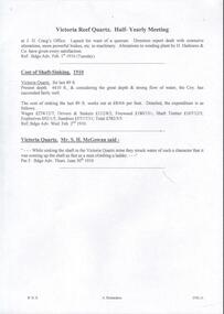
Document - VICTORIA QUARTZ - NOTES ON THE VICTORIA QUARTZ 1910
Handwritten notes on the Victoria Reef Quartz Half Yearly Meeting, Cost of Shaft Sinking and striking water at the Victoria Quartz Mine. Includes detailed expenditure of wages, Firewood, explosives, etc.document, gold, victoria quartz, victoria quartz, notes on the victoria quartz 1910, victoria reef quartz, j h craig, h harkness & co, bendigo advertiser 1/2/1910 - 2/2/1910 - 30/6/1910, mr h mcgowan -
 Bendigo Historical Society Inc.
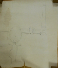
Document - MARKS COLLECTION: PLAN OF CHIMNEY STACK
Unlabeled plan, drawing shows side view of chimney stack, '5 feet' written on base of chimney. Plan could be associated with a mine on New Chum Reef Line, Victoria Hill.bendigo, mining, chimney side section, chimney stack -
 Bendigo Historical Society Inc.
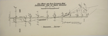
Map - RED WHITE AND BLUE EXTENDED MINE, 5/12/1940
Map: Transverse section of The Red, White and Blue Extended Mine, Sheepshead line of Reef, Bendigo. (9 Copies). By J.J. Caldwell, District Field Geologist, Mines Department Bendigo 5.12.1940map, bendigo, mining plan, red white and blue extended mine, sheepshead line of reef, mining , gold mines, j.j. caldwell -
 Bendigo Historical Society Inc.
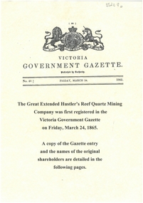
Document - GREAT EXTENDED HUSTLERS: GAZETTE ENTRY OF NAMES OF ORIGINAL SHAREHOLDERS
Display copy (3 pages) of the names of the original shareholders in the Great Extended Hustlers Reef Quartz Mining Co., first registered in the Victoria Government Gazette on Friday March 24, 1865.bendigo, mining, great extended hustlers -
 Stawell Historical Society Inc
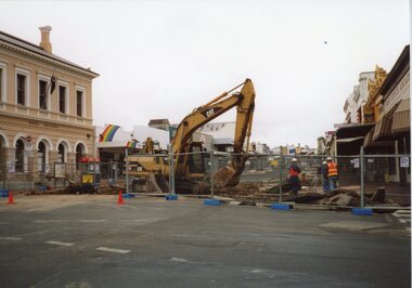
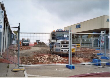
Photograph, Gold Reef Mall -- Main Street Stawell 2003
Gold Reef Mall Main Street 2003Colour Photograph: showing a digger and three men with helmets, two in hi-viz, behind temporary wire fence, Post office to the left.stawell business -
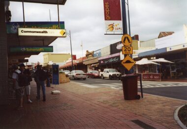
 Stawell Historical Society Inc
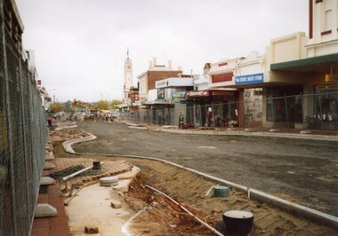
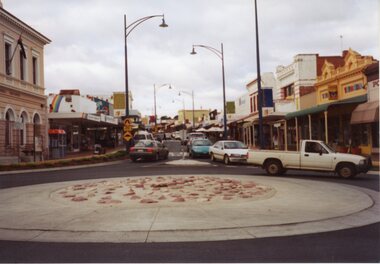
Photograph, Gold Reef Mall -- Main Street Stawell 2003
Gold Reef Mall Main Street 2003Colour Photograph: Looking Eastfrom the Main Street / Wimmera Street intersection, with roundabout partialy installedstawell business -
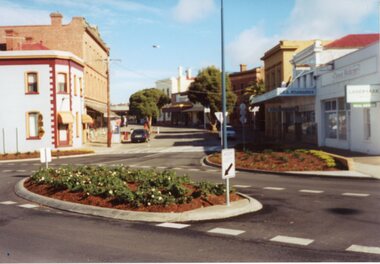
 Stawell Historical Society Inc
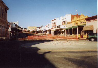
Photograph, Gold Reef Mall -- Main Street Stawell 2003
Gold Reef Mall Main Street 2003Colour Photograph: Looking West toward the Grampians, with curbing being installed.stawell business -
 Stawell Historical Society Inc
Photograph, Gold Reef Mall -- Main Street Stawell 2003
Gold Reef Mall Main Street 2003Colour Photograph: Looking West toward the Grampians from Victoria Place.stawell business -
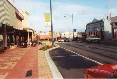
 Stawell Historical Society Inc
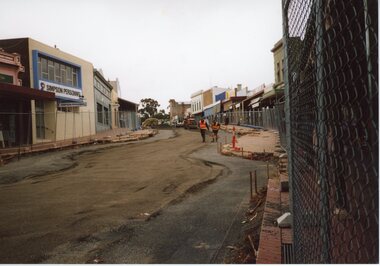
Photograph, Gold Reef Mall -- Main Street Stawell 2003
Gold Reef Mall Main Street 2003Colour Photograph: Looking East toward Big Hill. Two men in hi-viz walking toward camerastawell business -
 Stawell Historical Society Inc
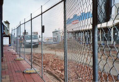
Photograph, Gold Reef Mall -- Main Street Stawell 2003
Gold Reef Mall Main Street 2003Colour Photograph: Looking West from near victoria Place, truck in mid distance.stawell business -
 Stawell Historical Society Inc
Photograph, Gold Reef Mall -- Main Street Stawell 2003
Gold Reef Mall Main Street 2003Colour Photograph: Looking East after the removal of the mall, from the Wimmera Street Intersection.stawell business -
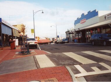
 Stawell Historical Society Inc
Photograph, Gold Reef Mall -- Main Street Stawell 2003
Gold Reef Mall Main Street 2003Colour Photograph: Looking East after the removal of the mallstawell business -
 Stawell Historical Society Inc
Photograph, Gold Reef Mall -- Main Street Stawell 2003
Gold Reef Mall Main Street 2003Colour Photograph: Looking Westafter the removal of the mallstawell business -
 Stawell Historical Society Inc
Photograph, Gold Reef Mall -- Main Street Stawell 2003
Gold Reef Mall Main Street 2003Colour Photograph: Looking West showing a Pedestrian crossing near Victoria Place.stawell business -
 Stawell Historical Society Inc
Photograph, Gold Reef Mall -- Main Street Stawell 2003
Gold Reef Mall Main Street 2003Colour Photograph: Looking West showing the Main Street / Patrick Street intersection.stawell business -
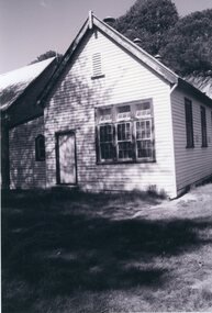 Stawell Historical Society Inc
Photograph, Rhymney Reef School
Plaques on Rhymney Reef Primary School site.B/W Photo of Wooden building with trees behind and grass in frontstawell education