Showing 10761 items
matching site
-
 Ballarat Heritage Services
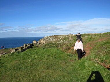
Photograph - Colour, Dorothy Wickham, St Just, Cronwall, World Heritage Site
A stone’s throw from Land’s End, this is the most westerly Area of the Site. St Just is characterised by big skies, jagged rocks, stark moorland, and iconic clifftop engine houses perched above the Atlantic in some incredible locations. No wonder this dramatic setting has inspired generations of artists, writers and photographers. World-famous for their mineralogy, the mining sites here are extremely well preserved – as is the sense of community amongst the people whose lives they once dominated. This Area’s unique geography and mineralogy meant that undersea mining was more concentrated here than anywhere else in the world in the 18th and 19th centuries. The oldest surviving Cornish beam engine (constructed in 1840) remains in its original engine house at Levant, restored and still working under steam. Geevor, one of the last mines to close in Cornwall (1990), was saved from demolition and is now the largest metalliferous mine site open to the public in the UK. The historic mining town of St Just is home to characteristic rows of granite mine workers’ cottages, public squares, shops, cafés, art galleries and, just off Bank Square, a medieval grassed amphitheatre – the Plen an Gwary or ‘playing place’.st just, world heritage, ellis, penrose, cornwall, mining, mines -
 Ballarat Heritage Services
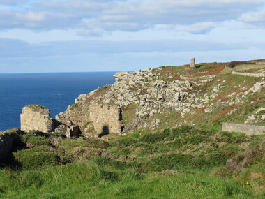
Photograph - Colour, Dorothy Wickham, St Just, Cornwall, World Heritage Site
A stone’s throw from Land’s End, this is the most westerly Area of the Site. St Just is characterised by big skies, jagged rocks, stark moorland, and iconic clifftop engine houses perched above the Atlantic in some incredible locations. No wonder this dramatic setting has inspired generations of artists, writers and photographers. World-famous for their mineralogy, the mining sites here are extremely well preserved – as is the sense of community amongst the people whose lives they once dominated. This Area’s unique geography and mineralogy meant that undersea mining was more concentrated here than anywhere else in the world in the 18th and 19th centuries. The oldest surviving Cornish beam engine (constructed in 1840) remains in its original engine house at Levant, restored and still working under steam. Geevor, one of the last mines to close in Cornwall (1990), was saved from demolition and is now the largest metalliferous mine site open to the public in the UK. The historic mining town of St Just is home to characteristic rows of granite mine workers’ cottages, public squares, shops, cafés, art galleries and, just off Bank Square, a medieval grassed amphitheatre – the Plen an Gwary or ‘playing place’.st just, world heritage, ellis, penrose, cornwall, mining, mines -
 Ballarat Heritage Services
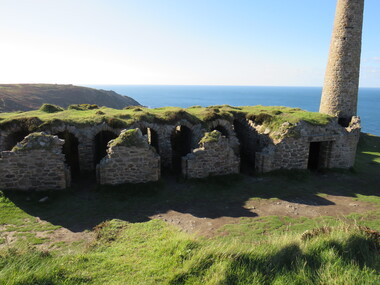
Photograph - Colour, Dorothy Wickham, St Just, Cornwall, World Heritage Site
A stone’s throw from Land’s End, this is the most westerly Area of the Site. St Just is characterised by big skies, jagged rocks, stark moorland, and iconic clifftop engine houses perched above the Atlantic in some incredible locations. No wonder this dramatic setting has inspired generations of artists, writers and photographers. World-famous for their mineralogy, the mining sites here are extremely well preserved – as is the sense of community amongst the people whose lives they once dominated. This Area’s unique geography and mineralogy meant that undersea mining was more concentrated here than anywhere else in the world in the 18th and 19th centuries. The oldest surviving Cornish beam engine (constructed in 1840) remains in its original engine house at Levant, restored and still working under steam. Geevor, one of the last mines to close in Cornwall (1990), was saved from demolition and is now the largest metalliferous mine site open to the public in the UK. The historic mining town of St Just is home to characteristic rows of granite mine workers’ cottages, public squares, shops, cafés, art galleries and, just off Bank Square, a medieval grassed amphitheatre – the Plen an Gwary or ‘playing place’.st just, world heritage, ellis, penrose, cornwall, mining, mines -
 Greensborough Historical Society
Photograph - Digital Image, Willis Vale site, 2014_
Photograph of the site of the 'Willis Vale' homestead, home of the Partington family. The derelict Willis Vale house was destroyed in 1964 when a fire originating from North Plenty Gorge - Kurrak Road - was lit by two teenage boys and made its way several kilometres down to Partington's Flat Greensborough.Digital copy of colour photograph."This house is where Willis Vale homestead was on Partingtons Flat"partington family, willis vale -
 Lakes Entrance Historical Society
Photograph - Site of original Harbecks store, M Holding, 2006
western corner of Carpenter Street and Esplanade shows Surf Shop and Fish and Chip shop facing Esplanade, Wells Fargo on corner and Senior Citizens Op Shop facing Carpener Street , Dr. Filewoods office extreme right side Lakes Entrance Victoria. Site of original Harbecks storeColour photograph of businesses near western corner of Carpenter Street and Esplanade shows Surf Shop and Fish and Chip shop facing Esplanade, Wells Fargo on corner and Senior Citizens Op Shop facing Carpener Street Dr. Filewoods office extreme right side Lakes Entrance Victoriabusinesses, restaurant, buildings -
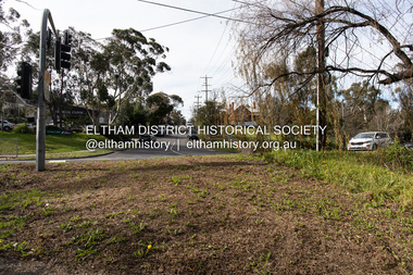
 Eltham District Historical Society Inc
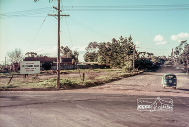
Slide, Site for the new Apex-Diamond Valley Ambulance Station, corner of Main Road and Grand Boulevard, Montmorency, July 1969, 1969
View looking west along Grand Boulevard from the intersection with Main Road and Panorama Avenue, Montmorency showing the site for the new Apex-Diamond Valley Ambulance Station and before construction of Apex Way, July 1969. The Eltham Apex Club conducted a Community Service Project (1965-1968) to raise funds for a new Ambulance Station to service the community. A site bounded by the intersection of Main Road, Grand Boulevard and Looker Road at Montmorency was purchased in 1969. In 1970, Eltham Shire Council undertook roadworks to construct Apex Way in preparation for the new station as well as duplicate Main Road, Lower Plenty, east of Grand Boulevard including the new Lower Plenty Bridge, which had been opened in November 1966, bordering with the City of Heidelberg.35 mm colour positive transparency Mount - Agfacolor Service (Blue)1969-07, ambulance station, apex way, grand boulevard, lower plenty, main road, montmorency, eltham ambulance station, apex-diamond valley ambulance station, eltham apex club -
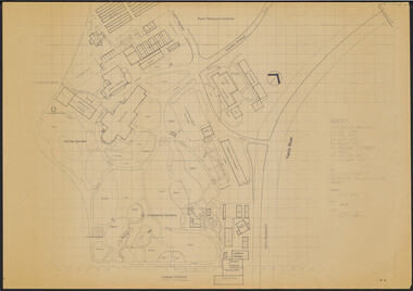
![Booklet: Historic Aradale [NMIT Site Plan and Introduction 2003], HiBooklet: Historic Aradale [NMIT Site Plan and Introduction 2003]](/media/collectors/4fac93a2023fd71f703efeec/items/50bbef912162ef06b884a6bc/item-media/50bc39322162ef06b884f20b/item-fit-380x285.jpg) NMIT (Northern Melbourne Institute of TAFE)
NMIT (Northern Melbourne Institute of TAFE)Booklet: Historic Aradale [NMIT Site Plan and Introduction 2003], HiBooklet: Historic Aradale [NMIT Site Plan and Introduction 2003]
Twenty-seven page colour booklet, with introduction and site plans for the Ararat Campus of NMIT, 2003. One large A3 copy and one smaller A4 copy. Also Program for Official opening of Aradale Campus Sunday 17 November 2002. Also large aerial photograph of Aradale campus 2003. Also VHS video Ararat Rural City Council celebrates rebirth of Aradale, Ballarat Win TV State television news 15/3/2002. Bill Braithwaite, Ararat Rural City Council, Peter Ray, NMIT.aradale, nmit ararat, aradale site plan, program for official opening 2002, nmit -
 University of Melbourne, Burnley Campus Archives
Plan, Victorian College of Agriculture and Horticulture - Burnley Site Plan, 1986
Given to Archives by Jim Galea (Staff 1985-87).Prints and paper copies of plan of Burnley Campus by Fresco Color Group No 60 337-A dated February 1986. Scale 1:500. (1) 3 prints of the plan, 1 small, 2 larger (1 with legend and grid). (2) Tracing paper copy, no legend, no grid. (3) Paper copy, legend and grid, of Ornamental Garden Area. (4) "Drawing Orchard Site Plan," grid and legend printed, the rest hand drawn. (5) Film and paper copies without grid and legend. N.B. 11.0716, Further development of Plan. vcah, burnley, fresco color group, orchard, burnley gardens -
 Falls Creek Historical Society
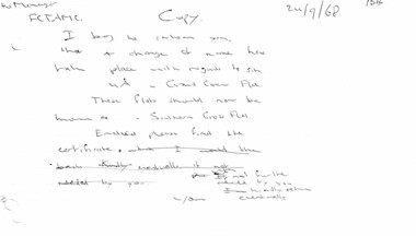
Document - Hand-Written Note - Change Of Name With Regards To Site 4a
Bob (Herman) Hymans (a former member of the Royal Netherlands Navy) was born in Bloemendaal, Holland on 30th September 1922. During World War II he fought against the Japanese in the Dutch East Indies (now Indonesia) and was imprisoned in Changi and on the Burma Railway. After gaining qualifications as a Ski Instructor, Bob arrived in Falls Creek in July 1950. Working as an Instructor and Supervisor at Bogong Lodge, Bob decided his future was in accommodation. He was successful in negotiating an indenture for land from the State Electricity Commission (SEC). It took Bob two years to build his Grand Coeur Chalet but, tragically, it was burned down in August 1961. Bob also built the first Chairlift in Australia. This was a single chairlift and the structure was built from wooden electricity poles. He was constantly full of new ideas and proposals for the village. Bob Hymans died on 7th July 2007. This Collection of documents and letters tells the story of Bob's endeavours to develop Falls Creek into the ski village it is today.This letter is significant because it reflects the relationship between Bob Hymans and the Management Committee.A note from Bob Hymans to the management committee reporting the change in name of his flats in Falls Creek.Transcript to Manager FCTAMC Copy 24/9/68 I beg to inform you that a change of name has taken place with regard to site 4A Grand Coeur Flats. These flats should now be know as Southern Cross Flats Enclosed please find the certificate (which I would like back. Kindly eventually if not needed by you). If not needed by you kindly return eventually The section in brackets had been crossed out.falls creek tourist area management committee, falls creek administration, bob hymans -
 Federation University Historical Collection
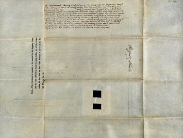
Document, Declaration of Ernest by owners of land in Yendon being held as a site for Public Hall and Free Library; 1891, 1891
Document outlining the agreement between five males, all residents of Yendon. Land that had been purchased - being part of Crown Allotment Five Section six, Township of Buninyong East, Parish of Buninyong, County of Grant, has been purchased "as a site for a public hall and free library for the use and benefit of the inhabitants of the Township of Yendon."Thick paper, hand written. Red dots indicate places for signatures Document stamped in green - 0122083 Signatures of; John Winterburn Kemp, Philip Ballantyne, Samuel Henry Mayo, Thomas Dooley, Thomas Watsondeclaration of ernest, land title, free library, public hall, yendon, buninyong, paris of buninyong, county of grant, john winterburn kemp, philip ballantyne, samuel henry mayo, thomas dooley, thomas watson -
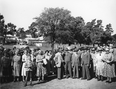 Stawell Historical Society Inc
Photograph, Gold Memorial site Stawell West with crowd of people c. 1950s- 2 Photos
Group of people at Gold Memorial site Stawell West c. 1950s Photograph taken Pomonal Rd - Burgh St Stawell West. Photo might have been taken at the opening of the Gold Memorial erected by the Stawell Progress Association located near Pleasant Creek where the first gold was found by William McLachlan May 1853?Two slightly different black and white photographs of a large group of people in an outdoor setting. Trees, buildings and Ute in the background.stawell -
 Whitehorse Historical Society Inc.
Photograph, Site of Barnard's Corner Store
Laser Print of black and white photo of Site of Barnard's Corner Store (2 copies) Boronia Road and Canterbury Road, Vermont. (Mounted) Barnard's Store was on the south-west corner of Canterbury Road and L.L. Vale Road (Boronia Road) Vermont. The old store was run by Miss Barnard. Mr Barnard had a Farriers Shop at the back of the store. The white gates on back centre of photograph in Canterbury Road is entrance to Uplands, home of Edward Bishop and Dr. Stephens. White fence on right hand side of photograph is entrance to home of Mr. & Mrs. Tilson who was a market gardener and orchardist.barnards corner store, uplands, vermont, stephens, dr., tilson, mr., tilson mrs, bishop, edward -
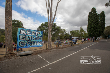 Eltham District Historical Society Inc
Photograph, Members of the community gather on the site of the former Shire of Eltham offices, Save Community Reserves Rally, Main Road, Eltham, 4 March 2018, 4/3/2018
Protest rally against Nillumbik Shire Councillors' proposal to sell off 17 community reserves. Held at the site of the former Shire of Eltham offices, at 895 Main Road, which were demolished in August 1996, followed by a march along Main Road finishing at the Eltham Railway Station car park at Luck Street. Estimated attendance was approximately 3,000.Born digital image (8)nillumbik shire council, parks, save community reserves, protest rally -
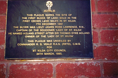 St Kilda Historical Society
Photograph, Plaque marking the site of the first block of land sold in the first Crown Land Sales in St Kilda 7 Dec 1842, c. 1980s?
colour photograph unmounted (2 identical photographs)This plaque marks the site of the first block of land sold in the first Crown Land Sales in St Kilda 7 Dec 1842. The buyer was Lieut. James Ross Lawrence, R N, Captain of the Schooner 'Lady of St Kilda'. He named Acland st after Sir Thomas Dyke Acland, owner of "The Lady of St Kilda". This plaque was unveiled by Commander RS Veale RAN (retd) CMG for St Kilda City Council. 24 March 1985. -
 Eltham District Historical Society Inc
Audio - Audio Recording, Audio Recording; 2018-06-13 Jim Connor and the history of the former Shire of Eltham office site, 13 Jun 2018
June Meeting (Newsletter No. 240, Jun. 2018) Prior to Shillinglaw Cottage (c1878-80) being relocated to where it is now operated as a popular cafe near the Eltham Library, it was within Josiah Holloway’s 1850s subdivision known as Little Eltham, which later became the centre of the first Eltham township. Originally a farmer’s cottage it is historically significant because it is one of the Shire’s oldest dwellings and a fine example of the work of the well-known pioneer builder George Stebbing. In 1964 the then Shire of Eltham purchased the Shillinglaw property with the intention of demolishing the cottage and constructing new Shire offices on the site. However extensive community action resulted in funds being raised to have the building saved and relocated further south to the Eltham Common, where it was joined by the Eltham Library 1994. New Shire offices opened in 1965, but following municipal restructure in 1994 these were demolished and the land sold to a developer, which precipitated a dramatic trail of community angst, threats of legal action, the sacking of a newly elected council and several unsuccessful development proposals, by subsequent councils. After all these years the vacant site there is still guarded by the three trees that were outside the front of the Shillinglaw Cottage. At our Society meeting on Wednesday 13th June 2018 Jim Connor will speak about the dramatic tale encompassing the history of the former Eltham Shire office site and the adjoining War Memorial Buildings complex, which are now being considered for sale or redevelopment by the current Nillumbik Shire Council.1:17:57 duration Digital MP3 File 27 MB audio recording, eltham district historical society, jim connor, meeting, shire of eltham office site, society meeting -
 Eltham District Historical Society Inc
Photograph, Peter Pidgeon, Site of the former Village Pond, Main Road, Eltham, 2 Aug. 2022
View looking up Dalton Street from near Main Road where the former pond was situated. The pond was drained by Council in 1932 due to concerns of mosquitoes, etc against the wishes of long standing residents such as Thekla Jarrold (39 years) and John Clark (22 years). On the right is the Eltham Primary Schoool No. 209 with the former Headmaster's residence and to the left is Eltham Clinic once the site of the Grant home.Born Digitaleltham, dalton street, main road, eltham clinic, eltham primary school, headmaster's residence, state school no. 209 -
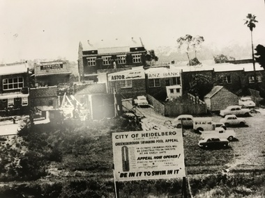 Greensborough Historical Society
Photograph, Greensborough Pool site, 1959c
The site of the Greensborough swimming pool taken from the corner of Grimshaw Street and Para Road. The barometer board shows the amount needed by public subscription. The two storey hall in the centre back had been the Rechabite Hall, later Masonic Hall then Ashril Theatre. The picture also shows the undeveloped nature of the area behind the Main St shops. This area was later sealed and made into the Carter car parking reserve. Part of a collection of photographic enlargements of Greensborough sites.Black and white enlargement of photographic imagegreensborough swimming pool, rechabite hall greensborough, ashril theatre -
 Eltham District Historical Society Inc
Photograph, Eltham - Shillinglaw Cottage on original site, 1964 - present day (1971) site of Shire Office
Shillinglaw Cottage is itself historically, aesthetically and socially significant to the Shire of Nillumbik and is registered on the Victorian Heritage Database. This photo forms part of a collection of photographs gathered by the Shire of Eltham for their centenary project book, "Pioneers and Painters: 100 years of the Shire of Eltham" by Alan Marshall (1971). The collection of over 500 images is held in partnership between Eltham District Historical Society and Yarra Plenty Regional Library (Eltham Library) and is now formally known as 'The Shire of Eltham Pioneers Photograph Collection.' It is significant in being the first community sourced collection representing the places and people of the Shire's first one hundred years.Digital imagesepp, shire of eltham pioneers photograph collection, eltham, shillinglaw cottage -
Koorie Heritage Trust
Book, Burke, Christine, Analysis of the lithic assemblage from the Keilor archaeological site : site number : 7822/010, 1990
58 P. appendices; bib. graphs; figs. map.sites - conservation and protection. | keilor /? maribyrnong river (melbourne vic sj55-05) | excavations (archaeology) -- australia -- melbourne (vic.) sites - conservation and protection -
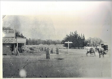
Ballarat Tramway Museum
Newspaper - Newspaper Clipping from Black and white photograph, The Courier Ballarat, Mt. Pleasant tram transferred to preservation site, 16/07/1972 12:00:00 AM
Black and White newspaper photograph taken by The Courier of Transferring No. 27 to the BTPS depot, while parked at depot junction. Has the destination of "Mt Pleasant" and a "Twin Lakes" front dash panel advertisement. Photo taken 16/7/1972, published 18/7/1972. See Reg. Item 1790 for the photo used in the newspaper clipping. Collected by Alan Bradley from the Ballarat Courier early 1980's. See Excel file "Record of Ballarat Courier Photos BTM era" (Archive Documents) for source of details. .1 - actual cutting from The Courier, with the caption "A tram in Ballarat is an unusual sight these days. This tram, which ran to Mt Pleasant is being transferred to the trams preservation site."tramways, trams, btps, moving trams, depot junction, tram 27 -
Federation University Historical Collection
Document - Journal Article, Locating the Eureka Stockade: Use of a Geographical Information System (GIS) in a Historiographal Research Context, 2003
Jack Harvey conducted research into the site of the Eureka Stockade. the research was published in 'Eureka Rediscovered'. Jack Harvey is a long term employee at the University of Ballarat.Six pages from the journal Computers and the Humanities 37 229-234, 2003. The article is by J.T. (Jack) Harvey and discusses the use of a Geographical Information System in the search for the Eureka Stockade site.eureka stockade, site, jack harvey, eureka, geographical information system -
 Glenelg Shire Council Cultural Collection
Photograph - Photograph - construction of wheat storage, Portland, c. 1970
Port of Portland Authority archivesFront: (no inscriptions) Back: Wheat storage site, June 8th (pencil, upper left)port of portland archives, construction, wheat storage -
 Eltham District Historical Society Inc
Audio - Audio Recording, Jim Connor - From Eltham to Nillumbik Shires and subsequent development proposals of the former Eltham Shire Office site - a personal perspective, 2 Jun. 2024
Guest speaker at Eltham Community Action Group (ECAG) Annual General Meeting The Shire of Eltham was established in 1871 and ceased to exist, due to a municipal restructure, when all councillors were sacked on 15 December 1994. Jim Connor, a past Councillor of the former Shire of Eltham and current President of the Eltham District Historical Society gave a very interesting presentation about the machinations of how and why Eltham became Nillumbik. He also displayed and discussed images of the various plans that have been suggested for the former Shire Office Site since the building was demolished by the decision of the commissioners in July 1996, the commissioners having replaced the elected council when the Kennett government amalgamated all Victorian councils.1:08:28 duration Digital MP3 file; 23.5MBaudio recording, meeting, eltham, guest speaker, commissioners, community engagement, community protest, council amalgamation, demolition, eltham gateway action group, eltham shire offices, jim connor, planning application, shire of eltham, shire of nillumbik, agm, eltham community action group (ecag), eltham district historical society -
 Mt Dandenong & District Historical Society Inc.
Photograph, View From Doughty's Road 1974
John Lundy-Clarke grew up in the Kalorama/Mt Dandenong area and later in life (1972-74) began to write a comprehensive history of the area working from an original settlement map in an effort to cover all areas. This photograph shows approximately the same area as photograph number KAL0193 but is taken 60 years later. The trees have grown much taller and the buildings changed. On the site of the Paynter house 'Iona' there is now the 'Yosemite' (Villa Toscana) accommodation. The pavilion in the centre of the photo is the site of 'Kalorama', home of early pioneer Isaac Jeeves. The photograph is taken looking up towards The Gap (FiveWays).Black and white photograph showing a forested area with clear sites. Roofs of buildings can be clearly seen. Handwritten inscription on reverse by John Lundy-ClarkeView from near Doughty’s Rd looking north up valley to Kalorama Gap in Jan 1973. Tiny roof in centre is pavilion on site of “Kalorama”. Long roof to its left is Yosemite Motel on site of “Iona”.paynter, kalorama, iona, yosemite, villa toscana, five ways, the gap -
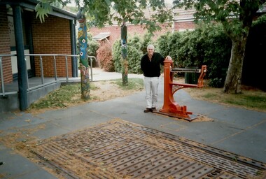 Surrey Hills Historical Society Collection
Photograph, Geoffrey Armitstead at the site of his grandfather's woodyard, Union Road, Surrey Hills, 2002 (1), 2002
Armitstead's woodyard was on the site later occupied by the Chandler Room of the Surrey Hills Neighbourhood Centre. Stephen Godfrey Armitstead started the woodyard in 1921, taking over from Long's woodyard. Taken over by Stephen's son, Leo Godfrey, it closed in the 1970s. After Leo's death it was managed by Hec Whitworth. The Armitstead family lived at 79 Croydon Road. 1931 electoral roll: Catherine Isobella, Ellen Florence, Leo Godfrey (woodworker), Stephen Godfrey (wood merchant) and William Ginchrist (joiner) at this address. Leo later lived at 75 Croydon Road. Stephen Godfrey Armitstead birth - Father's Name: Stephen Armitstead; Mother's Name: Emily Benbow; Birth Place: Hotham, Victoria; Registration Year: 1879; Registration Place: Victoria; Registration number: 23856. Spouse Name: Isabella Jane Cath Miller; Marriage Place: Victoria; Registration Place: Victoria; Registration Year: 1904; Registration number: 4534. Stephen Godfrey Armitstead death - Surrey Hills, Victoria; Age: 90; Father's Name: Stephen; Mother's Name: Emily Benbow; Registration Year: 1969; Registration Place: Victoria; Registration number: 27747. Geoffrey Armitstead, grandson of Stephen, visited the site in 2002 whilst in Melbourne from Brisbane. He recalled that during his summer school holidays that he delivered ice to household icechests. His cousin Marcia Davis, daughter of Ellen Armitstead, accompanied him and provided the family photos for copying and related her knowledge of the family history. The weighbridge and scales were moved in 2023 from their original position when the forecourt of the Neighbourhood Centre was upgraded by Council. The carved poles were also moved; they were repositioned as a group adjacent to 151 Union Road.Colour photo of Geoffrey Armitstead standing next to the scales in the Armitstead Courtyard of Surrey Hills Neighbourhood Centre. In the foreground is the weighbridge that was also part of the woodyard operated by his grandfather, Stephen Armitstead. In the background is part of the Chandler Room of the Centre and two of the carved poles which illustrate elements of the history of Surrey Hills.union road, armitsteads woodyard, surrey hills neighbourhood centre, businesses, timber merchants, timber yards, stephen armitstead, geoffrey armitstead, weighbridge, long's woodyard, leo armitstead, hec whitworth -
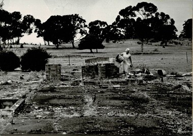 Tatura Irrigation & Wartime Camps Museum
Photograph, Dean Clark, Camp 3 Remains, 1989
Photograph of Lil Kuhnle walking through the remains of Camp 3. Copy of photograph original held by R & L. Kuhnle. Duplicate copy on foam.Black and white photograph of a lady remains of Internment Camp 3 site.on back: Lil Kuhnle - internment camp siteinternment camp remains, kuhnle l, dean clark -
Tatura Irrigation & Wartime Camps Museum
Photograph - copy, copy 1989
WW2 internment camp 1, Tatura, was built on land owned by Mr J. B. Noonah and consisted of mainly German internees. A large and modern hospital was located there. Black and white photograph of hospital site sign. No. 3 Internment campon back. Remains of hospital site, internment camp no. 3.internment camps, tatura internment camps, j. b. noonan, german internees -
 Ballarat Heritage Services
Photograph - Colour, Stonework, Old Sarum, England, English Heritage Site, 01 November 2016
William the Conqueror inherited Old Sarum from the last Saxon king of England. It was an ideal site for a royal castle. It was here in 1070 that William paid off his army after a long and bitter campaign in northern England. It was here in 1086 that he called together all the major landholders in England so they could swear allegiance to him. It was a crucial moment. The Domesday Book was being written, a threatened Viking invasion had only just been averted and William's eldest son was in armed rebellion. Old Sarum was an important place where this Norman king of England held power. In 1794 the Ordnance Survey set out to check the accuracy of the first mapping of Southern England, which had begun ten years earlier. From a point just below Old Sarum Lieutenant William Mudge laid out a base-line 36,574 feet (11,253 metres) long. From each end of the line the positions of distant places were plotted using a huge theodolite made in 1791 by Jesse Ramsden. The accuracy of the process, which was repeated all over England, depended on Jesse Ramsden's craftsmanship and on William Mudge's surveying skill in setting out this first base-line from Old Sarum. The nearer end of Mudge's line is marked by an inscribed stone beside the modern A345 at Old Sarum. ordnance survey, william mudge, jesse ramsden, william the conqueror, old sarum, saxon, 1086, england -
 Ballarat Heritage Services
Photograph - Colour, Stonework, Old Sarum, England, English Heritage Site, 01 November 2016
William the Conqueror inherited Old Sarum from the last Saxon king of England. It was an ideal site for a royal castle. It was here in 1070 that William paid off his army after a long and bitter campaign in northern England. It was here in 1086 that he called together all the major landholders in England so they could swear allegiance to him. It was a crucial moment. The Domesday Book was being written, a threatened Viking invasion had only just been averted and William's eldest son was in armed rebellion. Old Sarum was an important place where this Norman king of England held power. In 1794 the Ordnance Survey set out to check the accuracy of the first mapping of Southern England, which had begun ten years earlier. From a point just below Old Sarum Lieutenant William Mudge laid out a base-line 36,574 feet (11,253 metres) long. From each end of the line the positions of distant places were plotted using a huge theodolite made in 1791 by Jesse Ramsden. The accuracy of the process, which was repeated all over England, depended on Jesse Ramsden's craftsmanship and on William Mudge's surveying skill in setting out this first base-line from Old Sarum. The nearer end of Mudge's line is marked by an inscribed stone beside the modern A345 at Old Sarum. ordnance survey, william mudge, jesse ramsden, william the conqueror, old sarum, saxon, 1086, england