Showing 28524 items
matching street street
-
 Eltham District Historical Society Inc
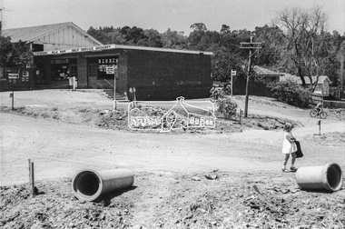
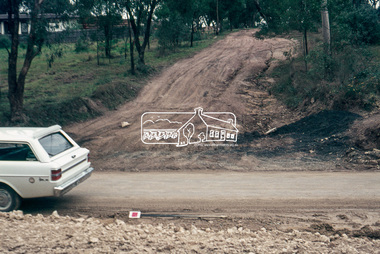
Photograph, Looking southeast towards Eltham Milk Bar at Bible Street and Pitt Street, Eltham, c.September 1966, 1966c
... Looking southeast towards Eltham Milk Bar at Bible Street...Bible Street, Eltham Milk Bar, Pitt Street, Road... area and crossed out Eltham-Yarra Glen Road, Bridge Street... melbourne Bible Street, Eltham Milk Bar, Pitt Street, Road ...Black and white photographic printOriginally located in a Filmpro King Size Prints processing envelope $3.01 Shire of Eltham 9/9/66 and noted as Calrossie Ave area and crossed out Eltham-Yarra Glen Road, Bridge Street to Elsa Court existing conditions mid 1967bible street, eltham milk bar, pitt street, road construction, streets -
 Eltham District Historical Society Inc
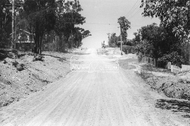
Photograph, Looking south along Bible Street towards Brougham Street, c. September 1966, 1966c
... Looking south along Bible Street towards Brougham Street, c...Bible Street, Brougham Steet, Road construction, streets... area and crossed out Eltham-Yarra Glen Road, Bridge Street... melbourne Bible Street, Brougham Steet, Road construction, streets ...Black and white photographic printOriginally located in a Filmpro King Size Prints processing envelope $3.01 Shire of Eltham 9/9/66 and noted as Calrossie Ave area and crossed out Eltham-Yarra Glen Road, Bridge Street to Elsa Court existing conditions mid 1967bible street, brougham steet, road construction, streets -
 Eltham District Historical Society Inc
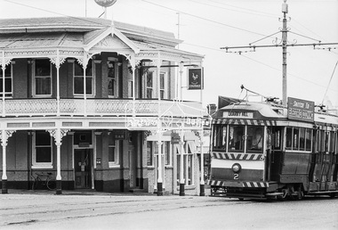
Photograph, Bendigo Tramways No. 2 en route from Quarry Hill outside the Victoria Hotel near the intersection of High Street at Victoria Street, Eaglehawk, January 1972, Jan 1972
... the Victoria Hotel near the intersection of High Street at..., high street, loddon valley highway, milk bar, street new...Looking northwest across High Street, Eaglehawk... melbourne Looking northwest across High Street, Eaglehawk ...Looking northwest across High Street, Eaglehawk at the intersection with Victoria Street. The Victoria Hotel is the present day New Victoria HotelDigital TIFF file Scan of 35mm Ilford FP3 black and white negative transparencybendigo, bendigo tramways no. 2, eaglehawk, eaglehawk mechanics institute, eaglehawk town hall, george coop collection, high street, loddon valley highway, milk bar, street new victoria hotel, pub, quarry hill, sailors gully road, tram, victoria hotel -
 Eltham District Historical Society Inc
Slide, Looking east up Baxter Street from Bolton Street, Eltham, 18 July 1972, 1972
... Looking east up Baxter Street from Bolton Street, Eltham...baxter street, bolton steet, bolton street shops, eltham...Reconstruction works by Eltham Shire Council, Bolton Street... Street, Eltham, 18 July 1972 baxter street, bolton steet, bolton ...Reconstruction works by Eltham Shire Council, Bolton Street, Eltham, 18 July 1972 35 mm colour positive transparency Mount - Agfacolor Service (Blue)baxter street, bolton steet, bolton street shops, eltham, eltham shire council, infrastructure, main road, road construction -
 Eltham District Historical Society Inc
Slide, Looking east up Thornton Street from Bolton Street, Eltham, 18 July 1972, 1972
... Looking east up Thornton Street from Bolton Street, Eltham..., road construction, thornton street...Reconstruction works by Eltham Shire Council, Bolton Street... Street, Eltham, 18 July 1972 bolton steet, eltham, eltham shire ...Reconstruction works by Eltham Shire Council, Bolton Street, Eltham, 18 July 197235 mm colour positive transparency Mount - Agfacolor Service (Blue)bolton steet, eltham, eltham shire council, infrastructure, road construction, thornton street -
 Eltham District Historical Society Inc
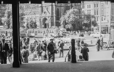
Photograph, George Coop, A day in Melbourne, Flinders Street Station, Swanston Street, November 1962, 1962
... A day in Melbourne, Flinders Street Station, Swanston...flinders street station, melbourne, St Pauls Church...GC took this photo at the entrance to Flinders Street... melbourne GC took this photo at the entrance to Flinders Street ...GC took this photo at the entrance to Flinders Street Railway Station under the clock looking out as everytime he arrived by train from Eltham and reached this point, it was like a portal from the quiet country into the hussle and bussle of the city - there is a lot going on this picture.Digital TIFF file Scan of 35mm Ilford FP3 black and white transparencyflinders street station, melbourne, st pauls church, swanston street -
 Eltham District Historical Society Inc
Photograph, Looking up Brougham Street towards Bolton Street, Eltham, c.1989, 1989c
... Looking up Brougham Street towards Bolton Street, Eltham, c... a photographic record of various new installations. eltham streets Bolton ...The Shire of Eltham was introducing a number of speed humps throughout the shire around this time period and took a photographic record of various new installations.Colour photographeltham, streets, bolton steet, brougham steet, infrastructure, speed humps -
 Eltham District Historical Society Inc
Photograph, Laneway running between Arthur Street and Luck Street (now Commercial Place), Eltham, c.6 May 1968, 1968
... Laneway running between Arthur Street and Luck Street (now...Arthur Street, Commercial Place, Eltham Shire Hall, Pryor... melbourne Arthur Street, Commercial Place, Eltham Shire Hall, Pryor ...35mm Colour positive transparency Mount - Agfacolor Service (Blue stepped)arthur street, commercial place, eltham shire hall, pryor street -
 Greensborough Historical Society
Photograph - Digital Image, Chris Foster, Main Street 1923 (Main Street Plaques Project), 17/05/2018
... Main Street 1923 (Main Street Plaques Project)...main street plaques project... in the Main Street area of Greensborough. In these photographs, GHS... Society placed plaques in the Main Street area of Greensborough ...In 2018, Greensborough Historical Society placed plaques in the Main Street area of Greensborough. In these photographs, GHS member Chris Foster has photographed the installation of the plaque of Main Street Greensborough 1923. The Main Street Plaques Project placed historical information about original Greensborough buildings as close to the original site as possible. Further information available on the GHS website. The Plaques were made possible through a Greensborough RSL Grant.Digital copy of 2 colour photographs.main street plaques project, main street greensborough -
 Eltham District Historical Society Inc
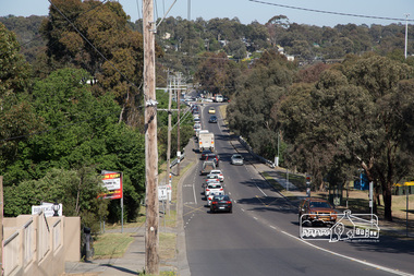
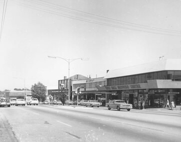
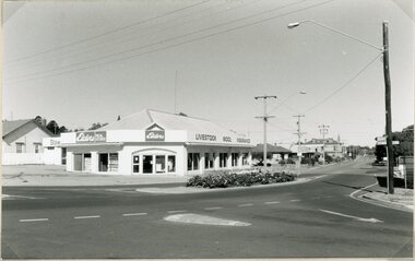
Photograph, Looking south along the east side of Main Road from Henry Street to Bridge Street, Eltham, February 1968, Feb 1968
... Street to Bridge Street, Eltham, February 1968...york street... at Pitt Street heading north along Main Road through the shopping ...Shows Warrens Fuel Merchant yard and Eltham Feed Store. Site of current Le Pine Funeral Home In February 1968 an unknown person took a series of photos from the Eltham Hotel at Pitt Street heading north along Main Road through the shopping centre to just north of Elsa Court covering the length of the section of Main Road which was duplicated shortly thereafter. Shows the condition and environment of the streesscape of Main Road, Eltham immediately prior to the duplication between Pitt Street and Elsa Court through the shopping centre. Also shows a number of shops and businesses that operated at that time.Black and white photographduplication, eltham, main road, briquettes, fuel merchant, le pine funeral home, york street, a.r warren, eltham feed store -
 Eltham District Historical Society Inc
Photograph, Peter Pidgeon, North bound traffic routed down Bridge Street during Bolton Street upgrade, Eltham, 13 November, 2017, 13/11/2017
... North bound traffic routed down Bridge Street during Bolton...bolton street upgrade...Bridge Street, Eltham, Victoria, Australia... melbourne bolton street upgrade eltham streets Bridge Street Born ...Born Digitalbolton street upgrade, eltham, streets, bridge street -
 Eltham District Historical Society Inc
Photograph, Peter Pidgeon, The last of the marquees from the Eltham Festival being disassembled viewed from Bridge Street during Bolton Street upgrade, Eltham, 13 November, 2017, 13/11/2017
... disassembled viewed from Bridge Street during Bolton Street upgrade...bolton street upgrade...Bridge Street, Eltham, Victoria, Australia... melbourne bolton street upgrade eltham streets bridge street Eltham ...Born Digitalbolton street upgrade, eltham, streets, bridge street, eltham festival -
 Ringwood and District Historical Society
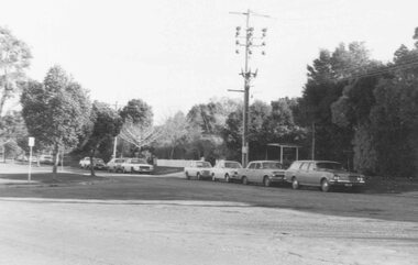
Photograph, Westward view from Seymour Street along Charter Street, Ringwood - 1981
... Westward view from Seymour Street along Charter Street...Written on back of photograph, "1981, Charters Street from..., "1981, Charters Street from across its junction with Seymour ...Written on back of photograph, "1981, Charters Street from across its junction with Seymour looking north-west. Staley Gardens on left. Telecom property on right." -
 Ringwood and District Historical Society
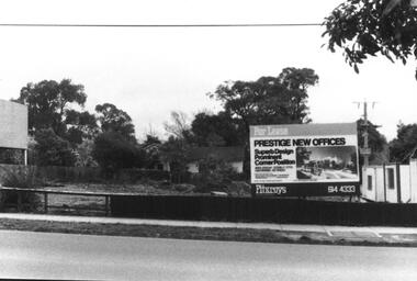
Photograph, Ringwood Street near Nelson Street Ringwood - 1987
... Ringwood Street near Nelson Street Ringwood - 1987...Written on back of photograph, "13/9/87. Ringwood Street..., "13/9/87. Ringwood Street near Nelson St." showing vacant ...Written on back of photograph, "13/9/87. Ringwood Street near Nelson St." showing vacant block with For Lease Prestige Office sign. -
 Ringwood and District Historical Society
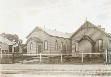
Photograph, Ringwood Methodist church and Sunday school c.1912, located on the corner of Main Street and Melbourne Street up until 1915
... on the corner of Main Street and Melbourne Street up until..., located on the corner of Main Street and Melbourne Street up until ...Written on backing sheet of one, "RWD Meth. Church and Sunday school, Main St. 1915. Cnr. Melbourne St." Other photograph in same sleeve states on back, "Methodist Church Ringwood. Cnr. Main St. and Melbourne St. Up to 1915" -
 Ringwood and District Historical Society
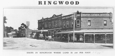
Photograph, Maroondah Highway Central, Ringwood. Block Emporium, corner Adelaide Street and Main Street. c1924
... Adelaide Street and Main Street. c1924.... Street and Main Street. c1924. Photograph ...Black and white photograph Typed below photograph: "Shops in Ringwood where land is £40 per foot - c1924". Written on rear of backing sheet: "Bloods' Store & Ringwood Coffee Palace, cnr. Main St. & Adelaide St c1924." -
 Ringwood and District Historical Society
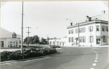
Photograph, Maroondah Highway Central, Ringwood. Melbourne Street to Ringwood Street - 1974
... Maroondah Highway Central, Ringwood. Melbourne Street to... photograph Maroondah Highway Central, Ringwood. Melbourne Street ...Black and white photographWritten on rear of backing sheet: "Main St., Melbourne St. to Ringwood St., 1974." -
 Ringwood and District Historical Society
Photograph, Trees lining north side of Maroondah Highway between New Street and Ringwood Street, Ringwood - 1926. Auction Sale sign is shown on the eventual Holeproof factory site, later street numbered around 103 Maroondah Highway, Ringwood
... Street and Ringwood Street, Ringwood - 1926. Auction Sale sign... New Street and Ringwood Street, Ringwood - 1926. Auction Sale ...Catalogue card reads, "Public Auction 1926. Saturday 29th May 1926. Holeproof factory once stood on this site. Billy Guyatt's discount store now occupies the site. (3 copies)". -
 Ringwood and District Historical Society
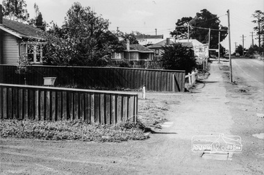
Photograph, Ringwood Street at Nelson Street Ringwood, looking south, early 1960s prior to Eastland development
... Ringwood Street at Nelson Street Ringwood, looking south..., "Nelson St." Ringwood Street at Nelson Street Ringwood, looking ...Black and white photograph showing made road. Telegraph pole on right of picture. Tall trees to left of photograph. Houses either side of road. Road sign on telegraph pole reads, "Nelson St."Typed below photograph, "Ringwood St. looking south. Ringwood Reserve to left of row of trees in centre." -
 Ringwood and District Historical Society
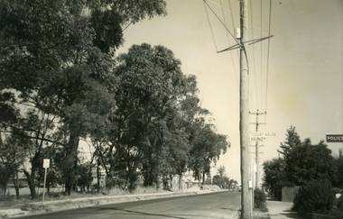
Photograph, Ringwood Street at Bourke Street Ringwood, looking south, early 1960s prior to Eastland development
... Ringwood Street at Bourke Street Ringwood, looking south... of street. Power pole to right of photograph with signage reading... photograph of road. Trees line left of street. Power pole to right ...Black and white photograph of road. Trees line left of street. Power pole to right of photograph with signage reading, 'Court House' and 'Bourke St.' Police station sign to right of picture.Typed below photograph, "Ringwood St. looking south. Ringwood Reserve on left". -
 Ringwood and District Historical Society
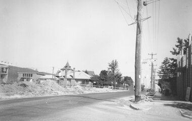
Photograph, Ringwood Street at Bond Street Ringwood, looking south, early 1960s prior to Eastland development
... Ringwood Street at Bond Street Ringwood, looking south...". Ringwood Street at Bond Street Ringwood, looking south, early 1960s ...Typed below photograph, "Ringwood St. - The building of the Church of England and the vestry. Looking towards Civic Place. Eastland Car Park Civil Works on left". -
 Eltham District Historical Society Inc
Photograph, Margaret Ball, Looking towards Bible Street along Dudley Street, Eltham, June 1999, 1999
... Looking towards Bible Street along Dudley Street, Eltham...dudley street...Dudley Street, Eltham, Victoria... in Eltham between Main Road and east to Bible Street, between Cecil ...The Margaret Ball (Pre 1960s Houses) Collection was a personal project initiated to mark the year 2000 and arose as a result of the disappearance of many pre-1960s parts of Eltham due to development. Approximately 200 pre-1960s style houses that were left in Eltham between Main Road and east to Bible Street, between Cecil Street to the north and south to Dalton Street were photographed in late 1999. Not all of the houses could be photographed; some because the garden or trees blocked the view of the house, others because of rubbish or cars were in the way, some because people were working on the house or in the gardens at the time.Roll of 35mm colour negative film, 5 of 6 stripsFuji 200eltham, houses, streets, margaret ball (pre 1960s houses) collection, dudley street -
 Ringwood and District Historical Society
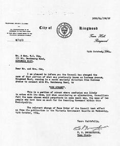
Photograph, Letter from Ringwood Council to change name of street to Oke Street, October 1964
... Letter from Ringwood Council to change name of street to.... Letter from Ringwood Council to change name of street to Oke ...Scanned on 30th January, 2008 from Ida Oke's albums. Ida lives in East Ringwood and also contributed to the East Ringwood Recollections book. Wife of Bob (Robert William) Oke. Both Ida and Bob were heavily involved in the Scout movement, as were Bob's parents - Corrie and Ruby (Guides) Oke, who both lived in Old Lilydale Road, East Ringwood. -
 Stawell Historical Society Inc
Photograph, Main Street and Patrick Street corner in Stawell 1996
... Main Street and Patrick Street corner in Stawell 1996...Corner of Main and Patrick Streets 1996... grampians Corner of Main and Patrick Streets 1996 Stawell Main ...Corner of Main and Patrick Streets 1996stawell -
 Nillumbik Historical Society Incorporated
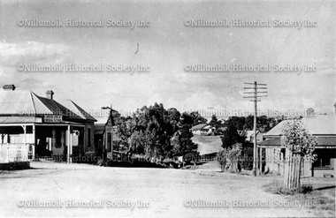
Photograph - Black & white photograph, View of Main Street towards Cowin Street, Diamond Creek c1920
... View of Main Street towards Cowin Street, Diamond Creek... of Main Street towards Cowin Street, Diamond Creek c1920 ...Black & white photograph -
 Nillumbik Historical Society Incorporated
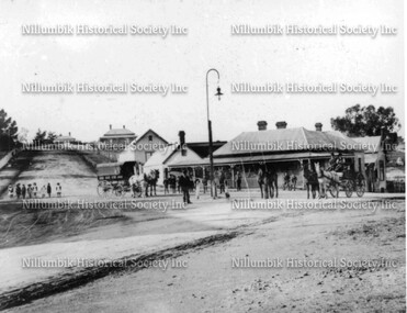
Photograph - Black & white photograph, Collins Street and Main Street corner Diamond Creek c1900
... Collins Street and Main Street corner Diamond Creek c1900... Creek Black & white photograph Collins Street and Main Street ...Black & white photographreeves store, gas lamps, diamond creek -
 Ballarat Heritage Services
Photograph - Photograph - Colour, Corner of Vickers Street and Albert Street, Sebastopol, 2020, 07/04/2020
... Corner of Vickers Street and Albert Street, Sebastopol...albert street...128 Albert Street, Sebastopol, Victoria, Australia... each day. sebastopol albert street south star mine mining ...The South Star Mine commenced operations in the 1880s and worke the quartz laods after the great floods of 1875 forced the closure of most alluvial mines. The South Star Mine sunk its first shaft in 1886, but broke into old alluvial workings and had to be abandoned because of flooding. The second shaft commenced in 1887, and was the deepest eer sunk in the Ballarat district, reaching 956 metres. 180 men worked three shifts each day.Colour photograph of the site of the South Star Mine in Sebastopol. sebastopol, albert street, south star mine, mining -
 Ballarat Heritage Services
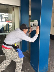
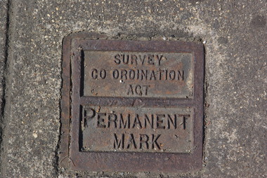
Photograph - Colour, Clare Gervasoni, Permanent Survey Mark on the Corner of Sturt Street and Doveton Street, Ballarat, 2011, 29/12/2011
... Permanent Survey Mark on the Corner of Sturt Street and...sturt street ballarat...Colour photograph of a metal survey mark in Sturt Street...Sturt Street, Ballarat, Victoria, Australia... Office goldfields sturt street ballarat survey mark Colour ...Colour photograph of a metal survey mark in Sturt Street, Ballarat. sturt street ballarat, survey mark -
 Stawell Historical Society Inc
Photograph, Stawell Hospital from Main Street with Wimmera Street on left and Scotland Place on right c1930-1940
... Stawell Hospital from Main Street with Wimmera Street on...Stawell Hospital from Main Street 1930's- 1940's. Wimmera... grampians Stawell Hospital from Main Street 1930's- 1940's. Wimmera ...Stawell Hospital from Main Street 1930's- 1940's. Wimmera Street on left and Scotland Place on right. J.C. Zala Electrical Contractor and W.E. Coward Carpenter and Joiner signs on right.stawell hospital -
 Stawell Historical Society Inc
Photograph, Main Street and Patrick Street corner in Stawell 1996
... Main Street and Patrick Street corner in Stawell 1996...Corner of Main and Patrick Streets 1996... grampians Corner of Main and Patrick Streets 1996 Stawell Main ...Corner of Main and Patrick Streets 1996stawell