Showing 458 items matching "subdivision map"
-
 Ringwood and District Historical Society
Map - Plan of Subdivision, Part of Crown Section 24, Parish of Warrandyte, County of Evelyn - undated, circa 1951
... Survey map of residential allotments in Milne Road, east ...Survey map of residential allotments in Milne Road, east of Berringa Road, Park Orchards, Victoria. -
 Greensborough Historical Society
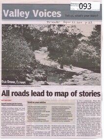
Newspaper - Newspaper clipping, All roads lead to map of stories, 27/04/2011
Family history of Josiah Holloway, origins of street names in the subdivision of Eltham History of Eltham and origins of street names connected with pioneers of the area.Newsprint, gray scale. Photograph of Keylock's Bridge on Diamond Creek at ElthamDV Leader April27 2011, p23josiah holloway, jack shallard, susanna maria bible, bradbury, henry brougham, handfield, fay harcourt, violet bank, kangaroo ground, bells hillroad, shalbury avenue, beard street, brougham street, main road, eltham -
 Ringwood and District Historical Society
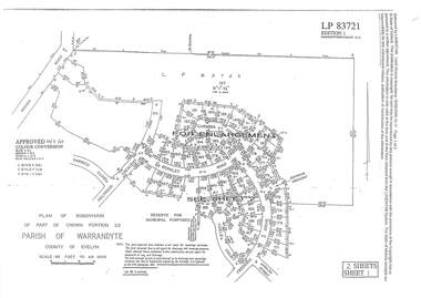
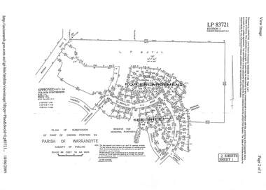
Document - Subdivision Plan, LP83721 Part of Crown Portion 23, Parish of Warrandyte, County of Evelyn, Vol 8708 Fol 351, Vol 8745 Fol 148 and Vol 8751 Fol 034 - 1969
Double sided LANDATA Land Victoria 2-sheet plan printout dated 2009Sheet 1 map and Sheet 2 enlargement including Wonga Road, Holyrood Crescent, Harwick Close, Berkley Road, Frederic Drive, Kenwood Crescent, Adele Court and Marilyn Street, Ringwood. Markings also include LP83722 . -
 Ringwood and District Historical Society
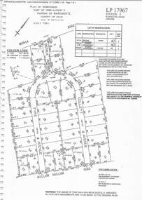
Document - Subdivision Plan, LP17967 Part of Crown Allotment 33, Parish of Warrandyte, County of Evelyn, Vol 6141 Fol 054 - 1948
LANDATA Land Victoria plan printout dated 2008Map includes Wonga Road, Berea Avenue, Fyfe Avenue and Collett Avenue, Ringwood. Markings also include PS309215, LP143952, LP210020, LP24182, LP70960, SP29097, RP9235, SP19956 and LP113437. -
 Ringwood and District Historical Society
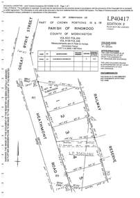
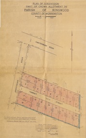
Document - Subdivision Plan, LP40417 Part of Crown Portions 16 & 18, Parish of Ringwood, County of Mornington, Vol 6231 Fol 035 and Vol 8139 Fol 248 - 1957
LANDATA Land Victoria plan printout dated 2008Map includes Heathmont Road, Heathmont, with allotments adjoining Railway Reserve. Other markings include LP95632NS. -
 Ringwood and District Historical Society
Document - Subdivision Plan, LP26914 Multiple Crown Allotments, Parish of Ringwood, County of Mornington, Vol 8021 Fol 053 - 1954
LANDATA Land Victoria plan printout dated 2010Part of Crown Allotments 1, 1A, 2, 3, 4, 5, 6, 7, 8, 9, 10, 55, 56, 57. Section C Crown Allotments 3, 12 & part of 2. Section B Map includes Bedford Road, Government Road (later Bedford Park Road then Hill Street), Marwarra Street and Tooronga Road, Ringwood. (Sheet 1 of 2 - Sheet 2 not included with collection). -
 Ringwood and District Historical Society
Document - Subdivision Plan, LP10477 Parish of Warrandyte, County of Evelyn, Vol 2453 Fol 574 - 1924
LANDATA Land Victoria plan printout circa 2010Part of Crown Allotment 30. Map includes Warrandyte Road, Kennedy Avenue and Wonga Road, Ringwood. Street name amended from Wonga Road to Loughnan Road 1940. Other markings include CP102182, CP171386, LP127934, PS349846, RP7582, PS309312,RP8679 and CP106336. -
 Ringwood and District Historical Society
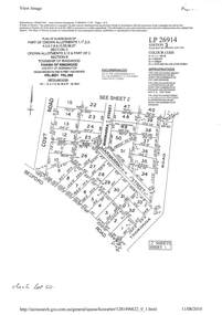
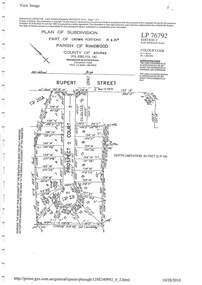
Document - Subdivision Plan, LP76792 Part of Crown Portions 19 & 20A, Parish of Ringwood, County of Bourke, Vol 8382 Fol 140 - 1967
LANDATA Land Victoria plan printout dated 2010Map includes Rupert Street and Prospect Court, Ringwood. -
 Ringwood and District Historical Society
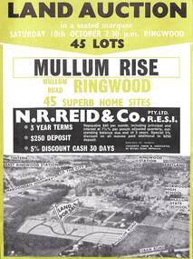
Flyer, Land Auction Advertisement, Mullum Rise, Ringwood - 1970
Double sided leaflet with aerial view of part of Ringwood showing subdivision site, terms of sale, layout of streets and allotments, and summary of local features and services. Additional printout of map with handwritten real estate sales notations includes prices for some allotments.Land auction, Saturday, 10th October (1970). 45 home sites. Subdivision includes Mullum Mullum Road, Hugh Street, Rollington Drive, Cassandra Court, and Jeffrey Drive. Surveyors - R.G. Lee Pty. Ltd., 6 Davis Street, Richmond. Agents - N.R. Reid & Co., 173 Coleman Parade, Glen Waverley, (Telephone) 560 0355 A.H. 560 0361 and Safeway Centre, Boronia Road, Boronia, (Telephone) 762 1022 A.G. 795 2887, also at East Malvern and Mount Waverley. -
 Ringwood and District Historical Society
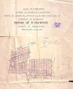
Map - Plan of Subdivision, Crown Allotments 4 and 5, and Parts of Crown Allotments 6, 8 and 9 Section B, Township and Parish of Ringwood, County of Mornington - Salter's Estate East Ringwood Victoria - 1956
... - 1956 Map Plan of Subdivision ...Land Title map of 51 allotments with property dimensions and handwritten real estate sales notations. Copy of map on cardboard backing - extracted from auction advertisement for Saturday, 10th November (1956).Subdivision includes Railway Avenue, Nicholson Street, Althol Grove (later Morcom Avenue), Illoura Avenue, Tweed Street, Merry Street, and Dublin Road, Ringwood East, Victoria. -
 Ringwood and District Historical Society
Document - Subdivision Plan, LP83721 - Part of Crown Portion 23, Parish of Warrandyte, County of Evelyn - 1969
... Two A4 maps of residential subdivision off Wonga Road...Two A4 maps of residential subdivision off Wonga Road ...A4 LANDATA Land Victoria plan printout dated 2009Two A4 maps of residential subdivision off Wonga Road, Ringwood. Enlargement map includes Holyrood Crescent, Berkley Road, Carmen Court, Frederic Drive, Kenwood Crescent, Marilyn Street and Adele Court. -
 Ringwood and District Historical Society
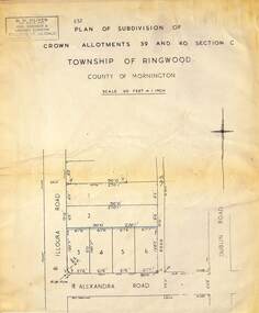
Map - Plan of Subdivision, Part of Crown Allotments 39 and 40 Section C, Township of Ringwood, County of Mornington - (Undated - circa 1930s)
... , Phone Lilydale 91. Copy of land title map on light cardboard ...Copy of land title map on light cardboard backing showing layout and size of 6 allotments in Illoura Road (later Illoura Avenue) and Alexandra Road, Ringwood East, Victoria. Rubber stamp imprint in top left corner - D.H. Oliver, Civil Engineer & Licensed Surveyor, Bellevue Street Lilydale, Phone Lilydale 91. -
 Ringwood and District Historical Society
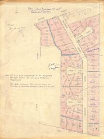
Map - Plan of Subdivision, Part of Crown Allotment 27 & 27B, Parish of Ringwood - (Undated, circa late 1950s)
... of Ringwood - (Undated, circa late 1950s) Map Plan of Subdivision ...Copy of land title map in manilla folder showing layout and size of 60 allotments in Railway Avenue, Victoria Street, Smithdene Avenue, Richard Court, Jeanette Court, Bruce Court and Loma Street, Ringwood East, Victoria.Note: Lot 15 is to be transferred to the Ringwood Borough Council for use as a children's playground. Map includes handwritten sales notations for several allotments, e.g. Sold. -
 Ringwood and District Historical Society
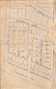
Map - Subdivision Plans, Residential allotments in Canterbury Road, Hume Street, Finlayson Street, Gray Street (later Grayview Avenue), and Thomas Street (later Gracedale Avenue), Ringwood East, Victoria - (Undated - circa 1950s)
... ), Ringwood East, Victoria - (Undated - circa 1950s) Map Subdivision ...Hand-drawn map on light cardboard backing. Multiple sets of numbered allotments, with un-numbered lots adjoining a drainage reserve north of Finlayson Street. -
 Ringwood and District Historical Society
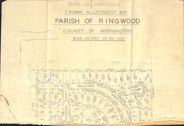
Document - Plan of Subdivision, Part of Crown Allotment 40C, Parish of Ringwood, County of Mornington - (Undated, circa 1960s)
Top portion (only) of clipped map on light paper backing showing residential allotments on The Boulevard, Wendy Court and Beverley Court, Heathmont, Victoria. -
 Ringwood and District Historical Society
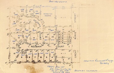
Map, Parkview Estate Subdivision, Heathmont, Victoria - 1965
... . Parkview Estate Subdivision, Heathmont, Victoria - 1965 Map ...Map showing residential allotments for sale in Reumah Court and Great Ryrie Street, Heathmont, Victoria.Hand-written heading and real estate sales notations include prices on several allotments. Terms £100 Deposit £15 monthly including interest 7% adjusted quarterly. Balance 4 years. Discount 5% cash. Brick and BV covenants. Contact Russell Leggo (Telephone) 940484. -
 Ringwood and District Historical Society
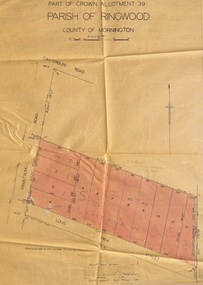
Map - Plan of Subdivision, Part of Crown Allotment 39, Parish of Ringwood, County of Mornington - 1949
... , County of Mornington - 1949 Map Plan of Subdivision ...Map showing residential allotments numbered 1 to 12 on Armstrong Road and Louis Street, Heathmont, Victoria.Certification signed and dated by Russell Francis Kinnane, Licensed Surveyor, 18th February, 1949. -
 Ringwood and District Historical Society
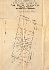
Map - Plan of Subdivision, Part of Crown Allotment 39, Parish of Ringwood, County of Mornington - (Undated, circa 1950)
... - (Undated, circa 1950). Map Plan of Subdivision ...Map showing residential allotments numbered 1 to 13 on Valdale Court and Armstrong Road off Canterbury Road, Heathmont, Victoria. Richard Rogalsky, Land Surveyor and Town Planner, 25 Napier Street, Essendon (at Essendon Junction) 37-2642 - 37-6570. -
 Ringwood and District Historical Society
Map - Plan of Subdivision, Part of Crown Allotment 39, Parish of Ringwood, County of Mornington - 1949
... , County of Mornington - 1949 Map Plan of Subdivision ...Map showing residential allotments numbered 1 to 18 on Armstrong Road and Harriet Street, Heathmont, Victoria.Certification signed and dated by Russell Francis Kinnane, Licensed Surveyor, 12th October, 1949. -
 Lakes Entrance Historical Society
Map - Map of Proposed Subdivision Lake Bunga Road County of Tambo, Paul Miller and Associates, 2000c
... Map of Proposed Subdivision Lake Bunga Road County of Tambo... are approximate and subject to survey Proposed subdivision Lake Bunga Road ...Proposed subdivision Lake Bunga Road Township of Cunninghame County of TamboDimensions shown are approximate and subject to surveydevelopment, surveying, housing -
 Ringwood and District Historical Society
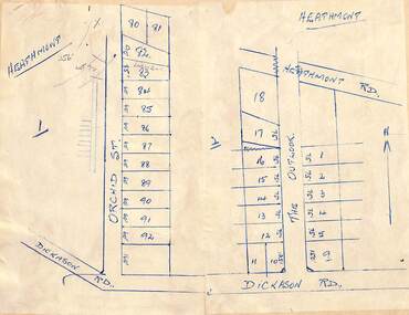
Map - Subdivision Plans, Residential allotments in Orchid Street and The Outlook, between Heathmont Road and Dickason Road, Heathmont, Victoria - (Undated - circa 1940)
... - circa 1940) Map Subdivision Plans ...Two adjoing hand-drawn maps on light cardboard backing. -
 Ringwood and District Historical Society
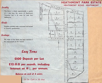
Document, Plan of Subdivision - Heathmont Park Estate (undated, circa 1949)
Land sale brochure clipping with map showing layout and sizes of 18 residential allotments in The Outlook, Heathmont Road, Allens Road and Dickasons Road, Heathmont, Victoria.Easy terms. £100 deposit per lot. £12:0:0 per month including interest at 6% per annum. Balance at end of 3 years. 5% for cash in 30 days. -
 Ringwood and District Historical Society
Map, Plan of Subdivision
... (undated circa 1940s). Plan of Subdivision Map ...Hand-drawn map on light cardboard backing. 20 residential allotments in Whitehorse Road, Everard Road and Kemps Street, Ringwood East, Victoria (undated circa 1940s).Vol 3956 Fol 015, Vol 4288 Fol 564, LP5252. -
 Ringwood and District Historical Society
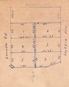
Document, Plan of Subdivision
Hand-drawn map on light cardboard backing. Six residential allotments in Glenvale Road and Hygeia Parade, Ringwood, Victoria (undated, circa 1940). -
 Ringwood and District Historical Society
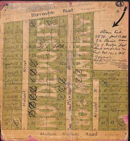
Map, Residential Subdivision Allotment Layout on Mullum Mullum Road, Hobart Street, Paxton Street, Arnold Street and Warrandyte Road, Ringwood, Vic. (Undated, circa 1920)
Map on cardboard backing clipped from Subdivision Plan 7578 - Part of Crown Allotment 32, Parish of Warrandyte, County of Evelyn.H.C. Crouch, Licensed Surveyor, 443 Lt Collins Street, Melbourne. Includes handwritten real estate sales notations and Certificate of Title reference - Vol 3922 Fol 784242. -
 Ringwood and District Historical Society
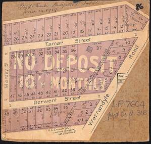
Map, The Ringwood Estate - Second Sub-Division, Ringwood, Victoria - 1919
Three cardboard-backed copies of map clipped from land sale auction brochure. Subdivision includes Warrandyte Road, Tamar Street, Mersey Street and Derwent Street.H.C. Crouch BCE, Licensed Surveyor, 443 LtCollins Street, Melbourne. Handwritten real estate notations in margins and on some allotments include sales information and reference LP7604 - Part of Crown Allotment 31B. Auction date June 14th, 1919. -
 Ringwood and District Historical Society
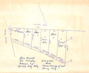
Document, Plan of Subdivision
Hand-drawn map of 6 residential allotments in Montalbo Road off Hygeia Parade, Ringwood, Victoria (undated, circa 1940).Real estate notations include prices, terms of sale, and a telephone number XM4200. -
 Ringwood and District Historical Society
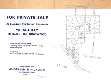
Document - Folder, Reaghill Estate Subdivision, Ringwood, Victoria - circa 1958
... with advertisement including map of original subdivision (circa 1958... with advertisement including map of original subdivision (circa 1958 ...Bifold land sale brochure glued to brown stationery folder with advertisement including map of original subdivision (circa 1958) and subsequent 1982 re-subdivision of Lot 7 Vista Avenue - LP41463 - Part of Crown Allotment 43, Parish of Ringwood, and 4-page brochure for sale of 4 luxury new homes built by Bovis Homes Aust. P/L as presented by Lyndsay Edmonds Homes. Subdivision includes Bedford Road, Homebush Court, Vista Avenue and Vista Court. Original protective covenant: "One dwelling house only on each of Lots 1-15 for a period of 15 years". Agent - Anderson & Hickling, 239 Collins Street, Melbourne. (Phone) Cent.25. -
 Ringwood and District Historical Society
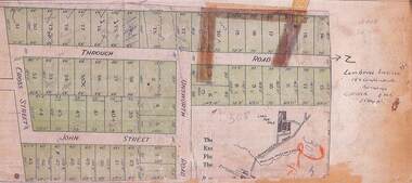
Flyer, Land Sale Advertisement - Unsworth Winmarleigh Estate, Ringwood, Victoria - circa 1912
... Advertisement and attachment for subdivision of land...Subdivision includes Wonga Road (later Loughnan Road ...Advertisement and attachment for subdivision of land adjoining Warrandyte Road coach route in North Ringwood, with map showing layout of subdivision, summary of local features and services, and terms of sale. Subdivision includes Wonga Road (later Loughnan Road & Warrandyte Road), Unsworth Road, Through Road, Cross Street, and John Street. Contacts - Mrs Unsworth on the Estate or W.M. Unsworth, 58 Little Latrobe Street, Melbourne, Telephone Central 7207. -
 Ringwood and District Historical Society
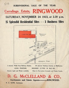
Flyer, Subdivisional Auction Sale Brochure, Carralinga Estate, Ringwood, Vic. - 1923
Double sided folded page with black and red print on both sides advertising auction sale of residential and business sites and highlighting local facilities, services and layout of the estateSubdivision includes Ringwood Street, Bourke Street and Bond Street. (Agent) D.G. McClelland & Co., Auctioneers and Estate Agents. Phone 37. R.G. Gunn, Auctioneer. Map includes location of Mr. McClelland's house on the corner of Ringwood and Bourke Streets.