Showing 382 items matching "table lined"
-
 Ballarat Tramway Museum
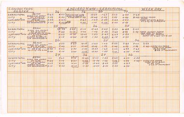
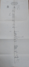
Document - Roster, State Electricity Commission of Victoria (SECV), "Conductors Roster", Mar. 1970
Demonstrates aspects of the Ballarat Tramways management system of Conductors rosters interfacing with Drivers during the last full period of operation of the tramway from March 1970. Shows the services and how the various run or crew tables were arranged in relation to the overall timetable.Handwritten sheet on graph paper for Weekdays and Saturdays Rosters for the arrangement on Mt Pleasant - Gardens, Victoria St - Gardens and Lydiard St Nth - Sebastopol routes. Gives the various run numbers, sign on location, trip take times, notes on what to do with trams, sign off times, interface with other runs. Shows the full service where conductors were used and how the various run or crew tables were arranged. See Reg item 3429 for Drivers table. Undated, but the sign on times for the conductor at the depot line up with the run times out of the depot for the Sebastopol route (See Reg Item 3426 and 2296.1) for March 1970. .1 - Weekday sheets - two sheets - orange ruled graph paper on white paper. .2 - Saturday sheets - two sheets - light blue ruled graph paper on white paper. See Reg Item 7131 for another item.trams, tramways, timetables, sec, ballarat, crews, conductors, rosters -
 Glenelg Shire Council Cultural Collection
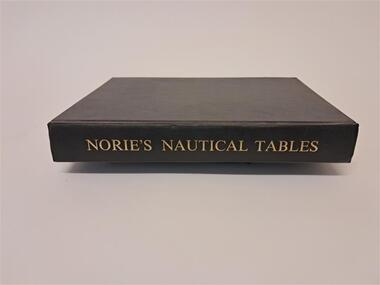
Book - Norie's Nautical Tables, Imray, Laurie, Norie & Wilson Ltd, 1981
This book contains nautical tables such as the Suns Total Correction, Table of the angles of the Mariner's Compass, Traverse Table, Logs. of Trig. Functions, Haversines, Hour angle etc.Black covered hard cover book. 546 pages plus an index.non-fictionThis book contains nautical tables such as the Suns Total Correction, Table of the angles of the Mariner's Compass, Traverse Table, Logs. of Trig. Functions, Haversines, Hour angle etc.nautical, angles, compass, logs, functions -
 Ringwood and District Historical Society
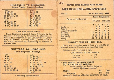
Card, Melbourne - Ringwood train time-tables and fares including off-peak tariffs
Bi-fold card for the Victorian Railways detailing time-tables and fares for the Melbourne-Ringwood line as at 10th May, 1953 -
 Ringwood and District Historical Society
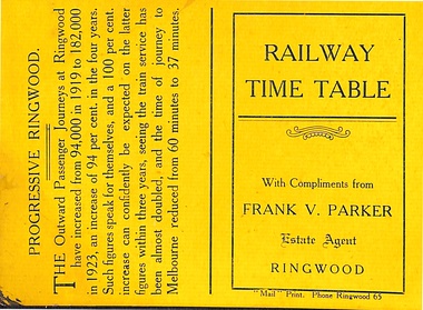
Card, "Mail" Print. Phone Ringwood 65, Railway Time Table with compliments from Frank V. Parker Phone 131 - Estate Agent. Ringwood to Melbourne and Melbourne to Ringwood
Small yellow card with Victorian Railways information detailing time-tables for the Melbourne-Ringwood line and a brief summary of increasing passenger usage from 1919 to 1923, including reduction of the time of journey from 60 minutes to 37 minutes -
 Ballarat Tramway Museum
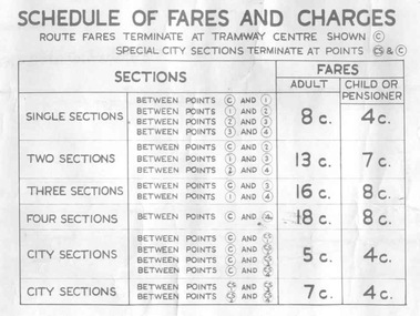
Poster, State Electricity Commission of Victoria (SECV), "Schedule of Fares and Charges - 26/1/1969", Jan. 1969
Demonstrates the way the SEC advised passengers in Ballarat and Bendigo how the fare and charges systems worked and yielded information about the fare charges in force at the time. A copy was provided in each tram behind framed glass.Dye line print of a drawing showing Bendigo Tramways (SEC) Fares, Charges, and Section Map. Drawing No. VX1/130/1 Also gives charges for Scholar's Monthly tickets, Luggage, Parcels, Newspapers and Chartered trams. Dated January 1969. Titled - "Schedule of Fares and Charges - 26 January 1969". Shows offices as Dispensary Walk. For map - see bgofsmap.jpg and for actual fare tables, btm1734i1.jpg and btm1734i2.jpg."BTPS" in blue ink on reartrams, tramways, bendigo, fares, sections, map -
 Ringwood and District Historical Society
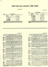
Pamphlet, First Box Hill Railway Time Table 1st December 1882
Yellow A4 sheet with black type. Includes Melbourne, Hawthorn, Camberwell, Box Hill and Ringwood on the Lilydale line. -
 Melbourne Tram Museum
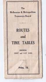
Map, Melbourne & Metropolitan Tramways Board (MMTB), "Routes and Time tables showing first and last cars", c1927
Folded map (5 x 3) by Melbourne and Metropolitan Tramways Board, c1927, of Melbourne tramways, showing tram routes (cable, electric and VR), railway lines, major points of interest and major streets. Titled "Routes and Time tables showing first and last cars". On rear shows maps of lines for the Eastern, Southern, Connection to Beaches and the Essendon, Maribyrnong and West Coburg lines. Dated c1927, shows the St Kilda Road lines to electric. On the bottom right hand corner has a reference to the Tramway Tourist Car - and the tours it does. (Reg Item 800 dated March 1927, shows the tram under construction). Second copy from Keith Kings Collection - in poor condition - added 10/8/2017The VR line has various hand written notations indicating it.trams, tramways, map, mmtb, tourist trams, y class, vr, cable trams, routes, timetables -
 Bendigo Historical Society Inc.
Document - CARSHALTON REEF, DIAMOND HILL MINES
... BENDIGO Mining carshalton reef line Table of information ...Table of information regarding the mines situated along the Carshalton line of Reef, includes Stafford Reef mine.bendigo, mining, carshalton reef line -
 Federation University Historical Collection
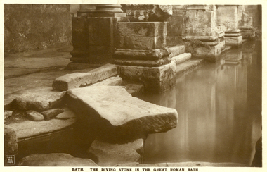
Postcard - Sepia, The Diving Stone in the Great Roman Bath, Bath, Somerset
The Great Bath is a massive pool, lined with 45 sheets of lead, and filled with hot spa water. It once stood in an enormous barrel-vaulted hall that rose to a height of 40 metres. For many Roman visitors this may have been the largest building they had ever entered in their life. The bath is 1.6 metres deep, which was ideal for bathing, and it has steps leading down on all sides. Niches around the baths would have held benches for bathers and possibly small tables for drinks or snacks. A large flat slab of stone is set across the point where hot water flows into the bath. It is known today as the diving stone. The Roman Baths complex is a site of historical interest in the English city of Bath. The house is a well-preserved Roman site for public bathing. The Roman Baths themselves are below the modern street level. There are four main features: the Sacred Spring, the Roman Temple, the Roman Bath House and the Museum, holding finds from Roman Bath. The buildings above street level date from the 19th century. Sepia postcard of a section of the Great Roman Bath at Bath, Somerset featuring the Diving Stone.printed verso: The Diving Stone in the great roman bath. The Diving stone, at the north-west corner of the great Roman Bath, still shows where the feet of bygone bathers wore away its surface. The hot mineral waters flowed into the bath through a channel under this stone. chatham-holmes family collection, bath, great roman bath, swimming pool -
 National Wool Museum
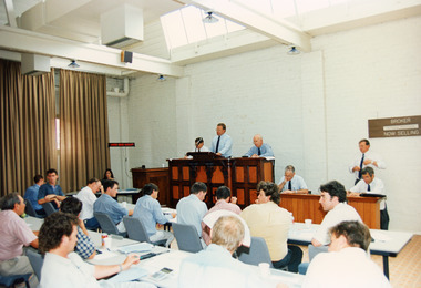
Photograph - Sale Room, National Wool Centre, Geelong, 11 January 1995
This photograph shows bidding underway for the million dollar bale in the Sale Room on the 11th January, 1995 at the National Wool Centre, Geelong. People depicted include Sale Team Baxter Murray, Auctioneer Michael Crooks and Wool Manager Keith Jackson. The wool was shorn from sheep of the Wyndarra and Rockbank bloodlines. A flock of 290 sheep were kept undercover at Kadinia, the property of the Appledore family from Brim in the Wimmera district of Victoria. Their record-breaking wool was produced by giving the sheep a special diet and providing each one with a UV-protective coat. Around 180 fleeces were selected for the million dollar bale. The sale of the first bale of wool measuring below 14 microns was held in the Auction Room here at the National Wool Museum. Bidding began at 40,000 (cents a kilogram) and steadily increased until there were only two bidders left. The bidders represented the Japanese firm Aoki International and Loro Piana of Italy. The hammer fell at 1,030,000 cents per kilogram, with Aoki International paying $1,194,800 for the 116kg bale. The fleece was scoured (cleaned) at the Goulburn Wool Scour, New South Wales. The degree of preparation and care taken with the task was extreme. The Scour closed production three days before and was extensively cleaned. On the day of scouring 12 tonnes of 17 micron wool was washed to condition the water, then nine bales of extra super fine wool, worth over $300,000 was washed as a trial run. Toabo Agaki Japan was employed to process the scoured wool into suit cloth. Taobo required the scoured wool to contain 0.5% residual grease, 12% moisture and a yield of 83kg. These requirements were met. The entire staff of the Scour wanted to be part of washing the best wool in the world. Without asking for payment both the night shift and afternoon shift crews assisted the day shift in the task. The bale was fed into the scour in seven minutes and fitted into three bowls, half the scour. It completely disappeared into the dryer and the last wool was fed before the first wool was out. The clean wool was hand-packed into cardboard cartons and freighted to Japan. Aoki International, based in Yokohama Japan, cut three suit lengths from the cloth, then blended the remaining wool into an exclusive line of commercially-available suits. These suits are labelled Kadinia.Colour photograph showing an interior view of people seated at rows of tables with an auctioneers stand at front of the room.michael crooks, auctioneer, wool industry, million dollar bale, geelong, auction, kadinia, appledore, keith jackson, sale room -
 Bendigo Military Museum
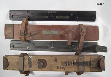
Instrument - Plane Table Surveying - Simple Alidade, ER Watts and Son, London, 1938
The Plane Table Alidade was used as the sighting Instrument in the production of historical manual hand drawn maps. A Plane Table Board mounted on a tripod is levelled and the Alidade is placed on the table with the vanes perpendicular to the it. Each sighting vane has a central thread lined up on the target and the angle to that target point is then drawn on the map sheet using the beveled fiducial edge. Plane Table Surveying is used as a quick method where less accuracy is required or needed. Plane table Surveying is a relatively portable and inexpensive method and was used extensively before the advent of sophisticated surveying instruments. The photo at 6489.2 is an Australian Army Survey Corps Party using a Plane Table Alidade in Syria during WWII. See also item 6580 which is the Plane Table with tripod legs that was used with the Alidade.Two Plane Table sighting instruments (Alidade) used for historical manual map making housed in wooden transit boxes. A brass instrument with folding sights at each end and a beveled fiducial edge in one edge. The front sight is the object vane and the rear sight is the sight vane. There is a sliding arm attached to the base to draw parallel lines to the fiducial edge. Very slight differences in model between these two instruments.First Instrument, "ER Watts and Son, London, 1938, MkII, Box Label 423. Second Instrument - R. E-Co, Mk.II, stamped E686, Box Label 686.royal australian survey corps, rasvy, fortuna, army survey regiment, army svy regt, asr -
 Melbourne Tram Museum
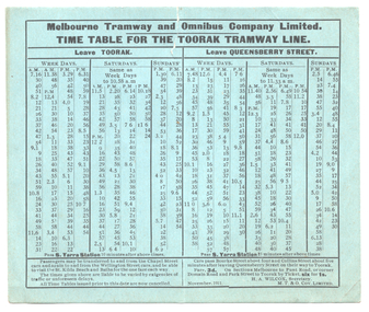
Ephemera - Set of 2, Melbourne Tramway and Omnibus Co (MTOCo), "Time table for the Toorak tramway line", Nov. 1911
The first copy printed on a light blue card provides departure times and some intermediate timings for the Toorak Cable Tramway operated by the Melbourne Tramway and Omnibus Co. from both the Toorak Rd terminus and Queensberry St terminus in Swanston St. Shows the frequency of the service, provides details of fares and transfer points. Signed by H A Wilcox Secretary and dated Nov. 1911. See item 7357 for the crew running timetable. Second copy on a buff coloured card has times for passing South Yarra station as well, dated 20/7/1909.Yields information about the running times for the public on the cable trams on the Toorak line. Set of two timetables printed on light card.timetables, tramways, cable trams, mtoco, toorak -
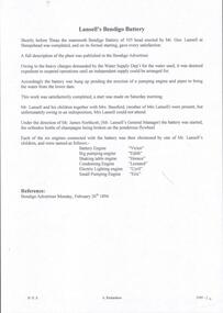 Bendigo Historical Society Inc.
Document - LANSELL'S BENDIGO BATTERY - NOTES ON LANSELL'S BENDIGO BATTERY
Two copies of notes on Lansell's Bendigo Battery. Ref. Bendigo Advertiser February 26th 1894. One copy is incomplete. Notes on formal opening of the 105 head battery, water supply and the Christening of the 6 engines connected with the battery by one of Mr Lansell's children. Another extract is from the Bendigo Advertiser dated Tuesday December 5th 1893 Page 3. Included in the notes is the description of the battery, driving engines, ripple tables, Halley's shaking tables, blanket tables, engines, Tambour Major plant, Mr Lansell, boilers, dams, the stack and names of engines Christened by one of Mr Lansell's children. Detailed description of the engines, etc.mining, surface equipment, lansell's bendigo battery, lansell's bendigo battery, notes on lansell's bendigo battery, bendigo advertiser 26/2/1894 & 5/12/1893, mr geo lansell, sheepshead line, water supply, mrs bassford, mr james northcott, tambour major coy, halley's shaking tables, johnson's gold mines, new red white & blue consolidated, north red white & blue -
 Bendigo Historical Society Inc.
Map - GREAT EXTENDED HUSTLER'S MINE - PLAN OF THE GREAT EXTENDED HUSTLER'S MINE
Plan of the Great Extended Hustler's Mine on the Hustler's Line of Reefs, Bendigo. Bulletin No 33, Plate No X. Lease No 7382. Plan has map of streets. Mine was located in the block bounded by Langston and Anderson Streets and was between the Hustler's Anticline at Surface and the Lightning Hill Anticline at Surface. Latham & Watson's Shaft is also mentioned. Levels are numbered and a table shows the Levels and their Depths. Geological Survey of Victoria. Signed by H A Whitelaw, Underground Survey Office, Bendigo, September 1913. This item has not been scanned or photographed.mining, parish map, great extended hustler's mine, hustler's line of reefs, mining lease no 7382, geological survey of victoria, underground survey office bendigo, h a whitelaw, latham & watson's shaft -
 Bendigo Historical Society Inc.
Map - FORTUNA HUSTLER'S MINE - TRANSVERSE SECTION OF THE FORTUNA HUSTLER'S MINE
Transverse Section of the Fortuna Hustler's Mine on the Hustler's Line of Reef, Bendigo. Bulletin No 33, Plate No III. Drawing shows poppet legs on the surface and Sill of Shaft 745.38 feet above Sea Level. Shows levels and their depths, geographical features and stone encountered. Reference table to stone and geographical features. Geographical Survey of Victoria emblem. Signed by H A Whitelaw, Underground Survey Office, Bendigo. mining, fortuna hustler's mine, hustler's line of reef, geological survey of victoria, underground survey office bendigo, h a whitelaw -
 Bendigo Historical Society Inc.
Map - HUSTLER'S REEF MINE - TRANSVERSE SECTION OF THE HUSTLER'S REEF MINE
Transverse Section of the Hustler's Reef Mine on the Hustler's Line of Reefs. Bulletin No 33, Plate No XVIII. Shows cross-cuts and their depth, different types of stone and geological features encountered. Drawing of poppet legs at the surface and Sill of Shaft 756.39 ft above Sea Level. Reference Table shows key to the different stone and geographical features encountered. Geographical Survey of Victoria. Signed by H A Whitelaw, Underground Survey Office, Bendigo, September 1913. Thompson's Reef is also mentioned on the map. mining, hustler's reef mine, transverse section of the hustler's reef mine, geological survey of victoria, h a whitelaw, underground survey office bendigo, thompson's reef. -
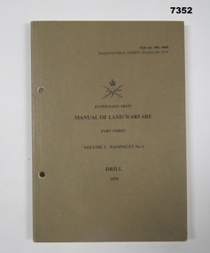 Bendigo Military Museum
Manual - LAND WARFARE, DRILL, ARMY, HEADQUARTERS TRAINING COMMAND, 3 May 1979
Manual consists of fiteen chapters related to drill movements. 1. Information for the Instructor. 2. Squad drill without arms - at the halt. 3. Marching. 4. Marching in line and changing direction and formation. 5. Rifle exercises at the halt and on the march. 6. Rifle drill for funerals. 7. Pistol drill - 9mm Browning. 8. Sentry Drill. 9. Quarter guards and sentries. 10. Sword Drill. 11. Drill with the cane. 12. Drill with the pace stick. 12. Unit drill - platoon drill. 14. Unit Drill - Company drill. 15. Unit drill - non-ceremonial. Plus list of illustrations, figures and tables. Part of the collection of KEVIN JOHN HERDMAN, No. 397661. See Cat. No. 5942P for details of his service record.Khaki coloured, textured soft covered manual with two punched holes for attaching to a ring binder. Title on front, cover in black type. Army logo in black. Pages are white in colour with black type. Black and white photographs and diagrams. Fifteen chapters. Pages glued to spine.drill movements, australian army, training manual, kevin john herdman -
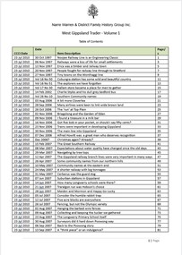 Narre Warren and District Family History Group
Booklet, Narre Warren & District Family History Group Inc, Casey Cardinia Collection - Selected articles from the West Gippsland Trader - Volume 1, 2010
Display book containing a table of contents and a selection of articles on Gippsland History by John Wells in the West Gippsland Tradernon-fictionwonthaggi railway line towns, great southern railway, baw baw track -
 Bendigo Historical Society Inc.
Map - HUSTLER'S REEF & HUSTLER'S REEF NO 1 MINES - PLAN OF THE HUSTLER'S REEF & HUSTLER'S REEF NO 1 MINES
Plan of the Hustler's Reef & Hustler's Reef No 1 Mines on the Hustler's Line of Reefs, Bendigo Bulletin No 33, Plate No XIV. No 8 connecting No 10 (Hustler's Reef), No 11 connecting No 13 (Hustler's Reef), No 13 (Hustler's Reef No 1) connecting No 15 (Hustler's Reef) and No 10 Hustler's Reef No 1 rise to Comet Mine. Map shows different levels in relation to the two shafts, the lines of the Hustler's Line of Reefs and the Lightning Hill Line of Reefs, the approximate Boundary of Lease and the Comet Co., the adjoining lease. Table on the left shows the levels and their depths of the two mines. Signed by H A Whitelaw, Underground Survey Office, Bendigo, September 1913. Geological Survey of Victoria emblem. mining, parish map, hustler's reef & hustler's reef no 1 mines, hustler's line of reefs lightning hill line of reefs, comet co., h a whitelaw, underground survey office bendigo, geological survey of victoria -
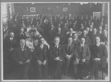 Melbourne Tram Museum
Photograph - Sargents Cafe 1923
This photograph shows approx 50 men in suits in a formal pose sitting and standing around tables, all facing the camera. The British flag hangs on one wall. Black and white photograph stuck on cardboard with biro note on rear. Sargents Cafe Elizabeth St City 1923. Send off to M A Browne Line manager Brighton Rd Car Housemen's group -
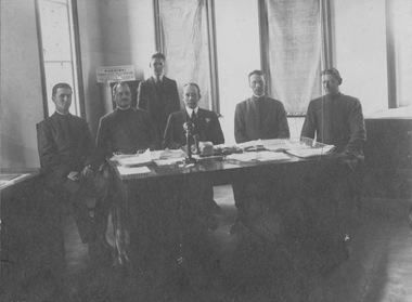 Melbourne Tram Museum
Photograph - Hawthorn Tramways Trust officers
Photograph of six male staff formally photographed at an office table. Two men in suits, four men in what appear to be uniform jackets. From the posture and grooming of the 'uniformed men', it could be inferred that they are senior traffic staff such as line inspectors.Yields information about administration of Hawthorn Tramways Trust Sepia toned black and white photograph glued to cardboard No inscriptions on rear but in the photo a notice headed 'Hawthorn Tramways Trust' can be seen. melbourne tramway and omnibus company, mt&oc, mtoc, cable tram, tramway board, tb -
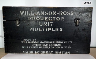 Bendigo Military Museum
Instrument - Multiplex Unit Projector, Williamson Manufacturing Co, Circa 1950
Multiplex mechanical stereoplotting equipment was used at the Army Survey Regiment, Fortuna Bendigo. c1950s. Multiplex equipment was imported from the UK in 1951 and introduced in the following year, to accelerate map production output covering CMF training areas at 1:25,000 map scale. Multiplex plotting was a productive advancement replacing the ‘Arundel’ method of graphical plotting planimetric detail that was expensive and slow, especially in timbered mountainous terrain. Air photos were made into small diapositives and mounted on racks in the exact position relative to when the aerial photos were taken. The technicians operated the Multiplex in a darkened room, with one photo projected with a green filter and the other through a red filter to form a 3D view of the overlapping photos. The 3D model projected onto a platen, which was a small platform that was raised up and down. The technician viewed the 3D image with special glasses fitted with red and green lenses. In the centre of the platen was a small pinhole that served as a floating mark, with a vertical pencil located exactly below the pinhole. This tracing table was moved to follow the topographic feature or contour line and draw it on the paper underneath. The technician raising or lowering the platform’s floating mark to match the height of the 3D terrain. It also replaced the slotted template method of mechanical adjustment of strips of aerial photography, however was restricted to each strip rather than between strips in the block. Although the Multiplex was phased out of production in 1968, it was used in the training of photogrammetry and aero-triangulation at the School of Military Survey located at Bonegilla, Victoria until the early 1990s. The history of the Multiplex is covered in more detail with additional historic photographs, in pages 50 to 51 of Valerie Lovejoy’s book 'Mapmakers of Fortuna – A history of the Army Survey Regiment’ ISBN: 0-646-42120-4. This instrument is only one of the projectors of a set and is unfortunately missing its platen, coloured filters and coloured glasses.A black wooden box containing a Multiplex Unit Projector (incomplete). The Multiplex has a Lamp Head, Barrel Housing, Body of the Projector and a Platen which is missing. .1 Protective wooden box .2 Multiplex Instrument .3 Multiplex Instrument Parts Diagram .4 A bank of Multiplex projectors in operation WILLIAMSON MANUFACTURING CO, PHOTOGRAPHIC ENGINEERS, SERIAL NUMBER 3437, TYPE MPC, LITCHFIELD GARDENS, LONDON AND READING.royal australian survey corps, rasvy, fortuna, army survey regiment, army svy regt