Showing 1233 items matching "the gap"
-
 Victoria Police Museum
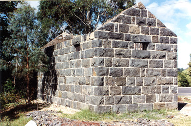
Police stations (Aitken's Gap)
Aitken's Gap, otherwise known as The Gap or Buttlejork, and 3km west of Sunbury, was established as a township in 1845. It is in the area which is now bordered by the Calder Highway and Gap Road. The village was named after John Aitken, a Port Phillip pastoralist who took up the Mount Aitken run in 1836. Aitken's Gap Police Barracks (in the District of Bourke) opened in 1853 and was staffed by two Mounted Constables and one Foot Constable. The gaol (used to house prisoners and also gold en route to Melbourne) was built in 1857 from bluestone quarried in the area. The roof was made of slate. In 1861 it was staffed by 1 Mounted Senior Constable and 1 Foot Constable. The Barracks closed in 1863 when the Bendigo rail line was completed and the gold was transported to Melbourne by rail. All the buildings, except the gaol, were moved to Sunbury. The land was sold in 1870 and in 1989 the current owner donated the building to the Sunbury Police. The original building was dismantled, restored and rebuilt outside Sunbury police station.15 colour photos and 1 black and white photopolice stations; aitken's gap police station -
 Halls Gap & Grampians Historical Society
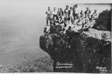
Photograph, C 1930s/40s
C 1930's/40's. This is a photo of a group of tourists on Lawson's Lookout, taken by Gilbert Rogers, a well known Hall's Gap photographer.The photo shows a group of twenty-one men and women posed on a rocky outlook. A bushy valley can be seen below with a road winding into the distance."Lawson's Lookout Rogers 1012" inscribed into lower part of photo.scenery, lookouts, people, tourists -
 Halls Gap & Grampians Historical Society
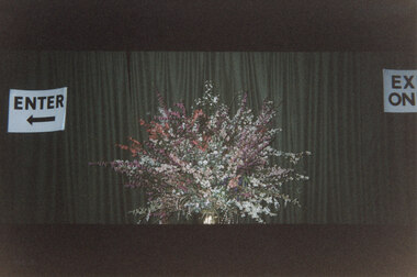
Photograph - Coloured, C 1997
This is an arrangement put together by Effie Walsgott. It was displayed at the entrance to the Halls Gap Hall during the 1997 Wildflower Show. ** there are 2 originals of the photo (& no copies).The photo shows a floral arrangement in front of a dark green curtain. There is an "Enter" sign to the left and part of an "Exit" sign can be seen on the far right.events, wildflower show -
 Halls Gap & Grampians Historical Society
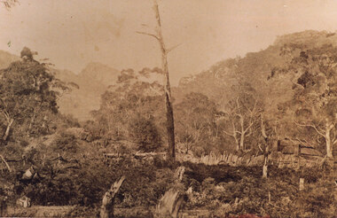
Photograph - Sepia, c 1876
Photo is of Delley's home with the " Watchtower�" in the background. Further information see "Bridging The Gap" p13-14,17,22,54. Records 544 & 545 are enlarged portions of this photo.Photo shows old house to right side of photo. There are two chimneys and the lower half of the house is obscured by a stick fence and undergrowth. The mountain range can be seen faintly in the distance. A dead tree can be seen middle foreground. buildings, houses -
 Halls Gap & Grampians Historical Society
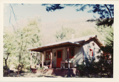
Photograph - Coloured, C early 1970s
The cottage was called "Hexham" and was a tourist 'rental' property. It was situated on Mackey's Peak Rd, Halls Gap. It was eventually demolished to make way for a private home.The photo shows a cottage with a verandah, surronded by trees which partly shade the right side. The window frames and door are painted red. A table and chair stand to the right side of the door and a deck chair and an arm chair are on the left side. "Kodacolor print, Kodak, April-71M" stamped on back in pink.buildings, houses -
 Stawell Historical Society Inc
Photograph, Aboriginal Collection Presented (Historical Society) in 1992, handing over artefacts from McNamara Collection to Brambuk Aboriginal Cultural Centre Halls Gap
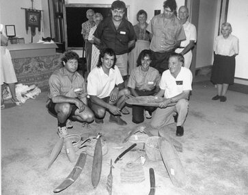
Aboriginal Collection Presented (Historical Society) 1992 handing over artefacts from McNamara Collection to Brambuk Aboriginal Cultural Centre Halls Gapstawell -
 Mt Dandenong & District Historical Society Inc.
Photograph
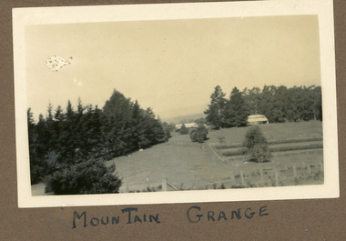
The photograph is from the album of Ivy Child. It shows a rare scene of the Mountain Grange Homestead. Mountain Grange was built by Thomas Hand on his 306 acres. By 1881 he had completed the homestead and a large barn. Thomas Hand died suddenly in 1888 and his family took over the property. His son William Hand lived in the homestead until 1931 until it was demolished due to white ants. The great barn was demolished in 1930. A new home was built and Will stayed until 1939 when the property was sold to the Shire of Lillydale. It is now the site of the Kalorama Oval. This photograph is c1927 Ivy May Child (1910 – 1989) was the daughter of Arthur Edward (Ted) Child (1878 – 1964) and Ethel May Madden (1888 – 1970). Ted Child was the son of Matthew Francis Child (1839 – 1933) and Martha Jeeves (1857 – 1926). He was the grandson of one of the early pioneers Francis Child. Ivy grew up on the family property on Childs Road and took many photographs. Most of these are glued into her photo album. The album covered the years from c1927 – 1932. Ivy married Henry William Burgess (1906 – 1968) in 1944. The photographs remain in their original state in the album with individual copies made. Black and white photograph showing a cleared area. There is a wire and posr fence in the foreground, a tall row of pine trees across the centre with two buildings visible. One in front of the trees RHS and he other in a gap in the centre. A crop has been planted in two long rows centre right of the photograph.Handwritten below the photograph in the album: MOUNTAIN GRANGEivy child, mountain grange, thomas hand, william hand, will hand, barn, great barn, homestead, shire of lillydale, kalorama oval -
 Beechworth Honey Archive
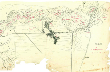
Hand-Drawn Map Centred on Buckland Gap Road by Frank Lebbell Frost July 1916
This is one of the maps drawn by Frank L. Frost while he was beekeeping in North-East Victoria. This particular map may be reference in the "Wooden" Diary on page 8.Hand-drawn map centred on Buckland Gap road (near Murmungee). Details the quantity and quality of flowering timber in the nearby State Forest. Scale is 1/2 mile to 1 inch. Map was drawn on the 16th July, 1916. Drawn with black pen and grey lead on paper. Features are marked in red.hand drawn, hand-drawn, map, buckland gap, frost, beekeeper, beechworth honey -
 Halls Gap & Grampians Historical Society
Photograph - B/W
Viewing area is known as The Balconies overlooking Victoria Valley. Photo is typical of tourism photos taken by the Victorian Railways during this period. c1950 -60'sa group of people (17) standing on a rocky ledge overlooking a treed valley. a second rock ledge is above them creating the impression of a large mouth. Printed on back: Copyright Photograph. This photograph may be reproduced on condition that it is acknowledged a s 'VICTORIAN RAILWAYS PHOTOGRAPH'. P3465 written faintly in pencil. The Balconies Halls Gap written in blue penscenery, lookouts -
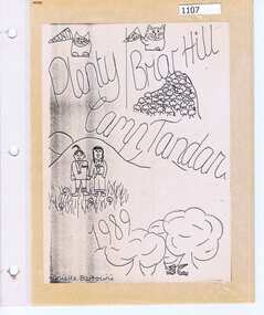 Greensborough Historical Society
Photograph Album, Plenty/Briar Hill Camp 1989, 04/09/1989
Photographs and maps from Plenty/Briar Hill Camp 1989. Possibly a school project, includes itinerary. Photographs are not named. Location: "Tandara" Halls Gap.Colour photographs and maps in albumHand drawn front cover with name of artist.plenty, briar hill -
 Halls Gap & Grampians Historical Society
Photograph - B/W
"Yarrabee" a holiday house in Halls Gap which was formerly a staff house for the construction of Bellfield Dam. A number of this houses were transported from job to job.A fibro cement house of simple rectangular construction, a low pitched roof ,sashed windows, a garage appears at the end of the driveway. Two cars are parked in driveway, gum trees surround the house. buildings, houses -
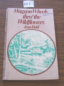 Stawell Historical Society Inc
Book, Jean Field, Wagon Wheels Thro’ the Wildflowers by Jean Field, 1877
This book is written about the family - Pioneers. Who followed Major Mitchell into teh areas around the Grampians & Under settlement of Horsham, Hamilton, Halls GapFawn cover with brown print. Green circular drawing showing a wagon carrying bales drawn by oxen with trees either side.stawell -
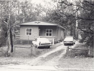
 Stawell Historical Society Inc
Photograph, Miss Agnes Folkes' Grave -- close to camping ground near Stony Creek in Halls Gap
Halls Gap. A Lonely Childs Grave (Agnes Folkes) close to camping Ground beside walk Stony Creek. The child's parents had a Sawmill nearby.halls gap -
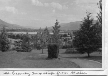 Kiewa Valley Historical Society
Photos - Mt Beauty and Surrounds, March 1960
Photos of the Kiewa Hydro Scheme and townships as they were in March 1960Pictorial record of the Hydro Electric Scheme in the 1960's when it was operated by the State Electricity Commission of Victoria (SECV). With the privatisation of the SECV in the 1990's the scheme passed to Southern Hydro and was then acquired by ALG Energy in 2005.4 black and white photographs of the Kiewa Valley area taken on a tour of the Kiewa Hydro Electric Scheme in March 1960 1. Mt Beauty township taken from the Mt Beauty Chalet 2. Mt Bogong, taken from Tawonga Gap 3. McKay portal pipeline 4. Bogong townshipmt beauty, kiewa hydro electric scheme, bogong, secv -
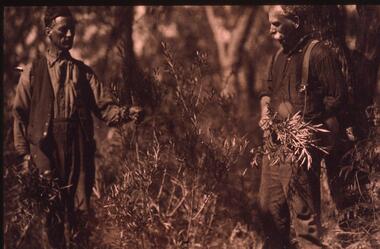 Halls Gap & Grampians Historical Society
Photograph - Transparency
Alfred D'Alton is on the left of the photo and his cousin Charles is on the right .The D'Alton's had a keen interest in wildflowers, being heavily involved in the Halls Gap Wildflower Show.Two men dressed in working clothes,one is wearing a vest, the man on the right has braces on his trousers. They are standing beside a bush from which they have picked branches. ...........................................................................................................people, d'alton -
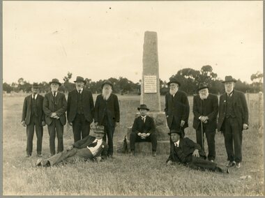 Stawell Historical Society Inc
Photograph, "Peace" Memorial on Halls Gap Road built 1919 at site of old Treasury Building Commercial Street Pleasant Creek c1922
Group of Gentlemen beside the Peace Memorial situated on Halls Gap Road built 1919 at site of old Treasury Building Commercial Street Pleasant Creek. C1922stawell -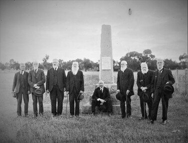
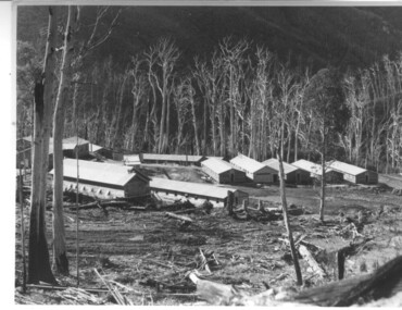 Kiewa Valley Historical Society
Photograph of Howmans Dam Camp, Howmans Dam Camp, circa 1948
Howman's Gap camp was erected in 1948. The proposed dam to be built at this site was postponed in 1954 because of financial restraints imposed by the government at this time. It was to have supplied water for No. 2 Power Station at the Junction of the Pretty Valley and Rocky Valley branches of the East Kiewa River. This power station was not constructed until 2008 - 2010 and now gets it water from McKay Creek Power Station. The site of this camp is now occupied by the Howman's Gap Alpine Centre. Some of the original buildings still remain. An excellent photographic record of the type of buildings and size of the camp for accommodation of workmen during construction of the Kiewa Hydro Electric Scheme.Black and white photograph of the buildings erected at Howmans Dam site as accommodation for workmen.Handwritten in blue ink on the back of photograph "Howmans Dam Camp"howman's gap, camp, water, dam -
 Mt Dandenong & District Historical Society Inc.
Photograph, View of the Kalorama Valley c1905
John Lundy-Clarke grew up in the Kalorama/Mt Dandenong area and later in life (1972-74) began to write a comprehensive history of the area working from an original settlement map in an effort to cover all areas. This photograph c1905 is looking up from George Barber's house 'Forest Edge' on Barbers Road. 'Forest Edge' was built c1898 and was the home of George Barber and his wife Sarah Ann (nee Richardson). The buildings in the foreground are the stables and hayshed.Black and white photograph showing two small buildings in the foreground with cleared hills behind. Handwritten decription on back by John Lundy-ClarkeA 1905 view of the Kalorama Valley towards the Gap. Barbers stables in foreground with hayshed on left. Tait’s house in centre of picture with Logans in the same fold above the hayshed. “Kalorama” is centre of Gap with Paynter’s “Iona” on its left with stables to its left. It was from one of these trees on the top left that the runaway log was cut that leaped over Barbers Road (at the top edge of the cleared land) then over Logan’s house in one bound in 1930.george barber, sarah ann barber, john lundy-clarke, forest edge -
 Halls Gap & Grampians Historical Society
Photograph - B/W, C 1934 (?)
This is a photo of participants in the "Queen Competition", which was held in the Halls Gap Hall. The Queen of Grampians House was Amy Johnson. See Record 4 for information about the Queen Competition.The photo shows a young girl dressed in a long white dress, with a large train, sitting on a throne. The has a small crown. On her left and right stand two young girls, also wearing long white dresses and head bands. To the far left is a young boy dressed as a page, holding a shield which reads :"Queen of Grampians House".recreation -
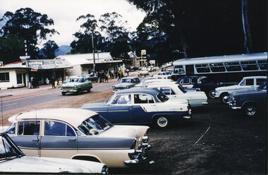 Halls Gap & Grampians Historical Society
Photograph - Coloured
This is the main street of Halls Gap, with the general Store and petrol station in view. The photo was taken at the time of the flower show; year unknown. A number of the cars are "F series" Holdens.The photo shows a shopping strip with numerous people in front of it, a road with a green car travelling along it (towards camera) and numerous cars and a bus parked on the other side (closest to camera).events, wildflower show, scenery, halls gap -
 Bendigo Historical Society Inc.
Document - JOAN O'SHEA COLLECTION: DUNNOLLY MAPS, 1980
Joan O'Shea Collection. Goldfield Maps Dunolly 3 Sheets 1980. Page 1: Mines in Dunolly, Whistling Flat, Painswick and Surrounds. Page 2: Mines in Goldsborough, McKinnons Gap, Bealiba Range, Stewarts Flat and Surrounds. Page 3: Mines in Dunolly, Emu Creek, Bet Bet, Bromley & Surrounds. Scale in Chains and Kilometres.GoldField Maps 1980 based on Dunolly 7624 by Division of National Mappinggold, goldfields, goldfield maps dunolly & surrounds -
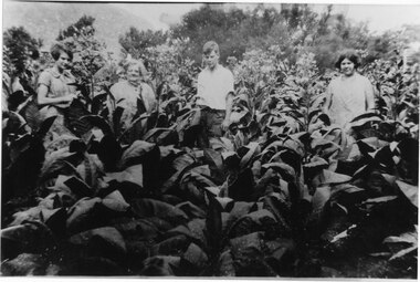 Halls Gap & Grampians Historical Society
Photograph - B/W
Growing tobacco at Morningside Halls Gap, Lorna (Topsy) Warren, Ronald Warren, Mrs Warren, Sheil (later Leighhead). One copy is a slide held in slide box No. 244.4 people in crop of tobacco Lorna Warren (Topsy), Ronald Warren, Mrs Warren, Sheila Warren (later Leighhead)Names of people in photographpeople, warren, misc industries, tobacco growing -
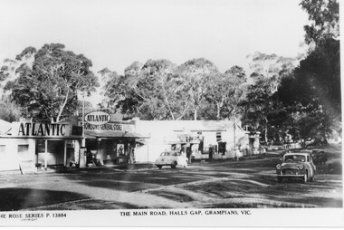 Halls Gap & Grampians Historical Society
Postcard - B/W, C 1950s
Thomson's and Taylor's shops with the Halls Gap Hall further along the road. A number of 1950's vintage cars are parked along the main road. No. 13884 in the Rose Series of postcards.A strip of shops along a bitumen road. One shop is a garage with Atlantic signs and another has a sign that reads "Thomson's General Store". There are several cars parked along the road and eucalyptus trees in the background.buildings, shops -
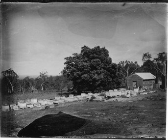 Halls Gap & Grampians Historical Society
Photograph - B/W
The photos show the Russell bee-hives at Roses Gap. The tree near the hut is the present site of Chinaman Lodge home. One of the copies is a transparency located at No 243 in the slide box.The photos show a group of bee-hives lined up in front of a timber shed. The hives and shed are in a clearing. There is a large tree near the shed and the clearing is edged with thick bush in the background. The two copies are of two photos taken at slightly different angles and distances from the shed.misc industries, bee-keeping, scenery, cherrypool -
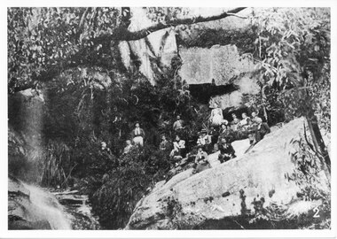 Halls Gap & Grampians Historical Society
Photograph - B/W, C ?
This photo has been copied from an article in the Weekly Times. The falls were in the Roses Gap area and there was once a track leading there. It is probable that the group went there by horse drawn vehicle.The photo shows a group of adults seated on a rocky outcrop at the base of a waterfall, in bushland beside a running creek (at left of photo). All are dressed formally.scenery, waterfalls -
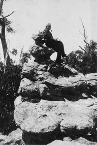 Halls Gap & Grampians Historical Society
Photograph - B/W
Man was Freddie Paash, a Danish immigrant who made his home in Halls Gap. He is seated on what was known as the 'Coronation Chair'. c1930s. This no longer exists as it was struck by lightning.Side view of Man, with hat in his hand, smoking a pipe, seated on top of rocky outcrop. Gumtrees and bush visible in background. c1930speople, paasch -
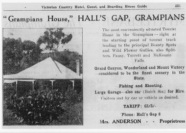 Halls Gap & Grampians Historical Society
Flyer - B/W, C 1924-25
Tariff L 3/3 Mrs Anderson was proprietress "Grampians House," Hall's Gap, Grampians, The most conveniently situated Tourist Home in the Grampians - right at the starting point of tourist track leading to the principal Beauty Spots and Wild Flower Gullies, also Splitters, Pansy, Turrett and McKenzie Falls Grand Canyon, Wonderland and Mount Victory considered to be the finest scenery in the State. Fishing and Shooting. Large Garage - also Car (Buick Six) for Hire. Visitors met by car of vehicle as desired. Phone Halls Gap 8Detail of advertisement for Victorian Country Hotel Guest and boarding house Guide with photo of original housemedia, flyers, accommodation, grampian house -
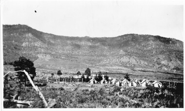 Halls Gap & Grampians Historical Society
Photograph - B/W, Mid 20th century
Work crews camping out at the junction of the Pines/Plantation road and the Halls Gap/Mt Zero Rd with the Mt Difficult range behing. Probably working on the Pine Plantations grown in the area.tents, tents -
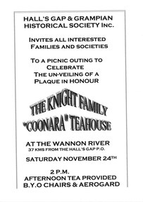 Halls Gap & Grampians Historical Society
Flyer - B/W, C November 2001
Halls Gap & Grampians Historical Society flyer for picnic outing to celebrate the unveiling of a commemorative plaque in honour of the Knight Family Coonara Teahouse. The unveiling was to take place on 24 November 2001.A copy of a flyer advertising the unveiling of a plaque at the site of the "Coonara" tea-rooms on the Wannon River.media, flyers