Showing 432 items matching "utility"
-
 Bendigo Historical Society Inc.
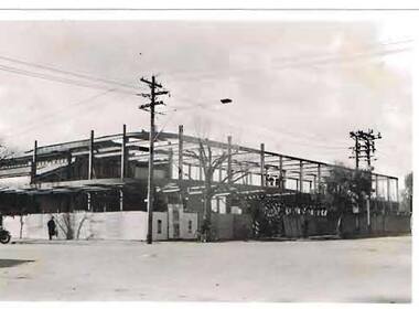
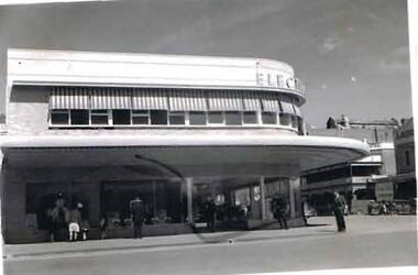
Photograph - S.E.C. VICTORIA, 1939
Photograph - black and white. The new SEC Victoria building under construction. Steel girders and framework being erected. 'Old Market' building can be seen through the girders at the left of photograph.organization, public utility, electricity company, s.e.c.victoria building. 1939. bendigo. -
 Bendigo Historical Society Inc.
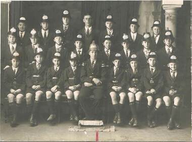
Photograph - BENDIGO EAST JUNIOR FIRE BRIGADE, 1937
Photograph - black and white. A photograph of a Junior Fire Brigade, Bendigo Easter Fair, 1937. 'First Prize - Section 10'. Cliff Hughes is the gentleman in the centre of the back row and Bruce Heider is fourth from the left of the sitting row.organization, public utility, fire brigade, bendigo east junior fire brigade. bendigo easter fair 1937. cliff hughes. bruce heider. -
 Bendigo Historical Society Inc.
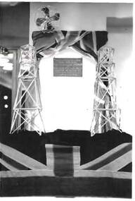
Photograph - S.E.C. VICTORIA, 1941
Black and White Photo of Official Plaque, Opening of the new S.E.C. Victoria Administration Buildings March 14 1941, Plaque reads 'This Building was offically opened by the Hon. F.E. Old. MLA. Minister in Charge of Electrical Undertakings 14 March 1941'. Flag wrapped around a bar at the top of the display, and fan. Another flag at the front bottom of the display. Rear of photo Sec. opening 14 March 1941 written in biro and number 30 written in pencil.organization, public utility, electricity company, s.e.c. victoria, sec victoria, sec victoria offical opening, sec victoria offical plaque -
 Bendigo Historical Society Inc.
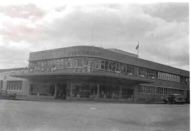
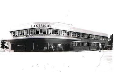
Photograph - S.E.C. VICTORIA, 1954
Black and White Photo of the S.E.C. Victoria Building, Decorated for the Royal Visit in March 1954, Opening of the S.E.C. Building in 1941. Car parked to left in photo, and another angle parked to right of photo. Flag on roof flying a half mast.organization, public utility, electricity company, s.e.c. victoria, sec victoria -
 Bendigo Historical Society Inc.
Photograph - S.E.C. VICTORIA, 1941
Black and White Photo of the S.E.C. Victoria Building, Limerick Castle Hotel is in the background, Opposite the S.E.C. Building is the Laurel Café Dining Rooms. A number of people (12?) looking in the windows. on right side cars angle parked in gutter, Horse with attendant. Rear of photo has 14/3/1941 written in biro and number 25 written in pencil.organization, public utility, electricity company, s.e.c. victoria, sec victoria -
 Bendigo Historical Society Inc.
Photograph - S.E.C. VICTORIA, 1941
Black and White Photo of the new S.E.C. Victoria Building, Back View. Foreground lawn area surrounded by rock edging. Two established trees along rock edging. Roadway running left to right. Another lawn area with established shrub in protective surround, and two more smaller shrubs in similar protection,organization, public utility, electricity company, s.e.c. victoria building, sec victoria building -
 Bendigo Historical Society Inc.
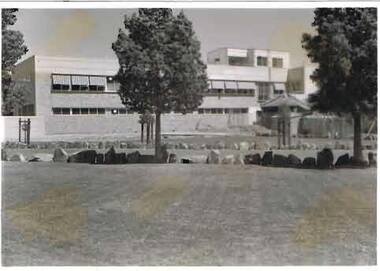
Photograph - S.E.C. VICTORIA, 1941
Black and White Photo, completed S.E.C. Victoria building, Taken March 14 1941, workers putting finishing touches to exterior of the building. person in light coloured clothing crossing the street, two darke coloured vehicles in the background. Rear of photo has 14.3.41 printed in biro and number 53 written in pencil.organization, public utility, electricity company, s.e.c victoria building, sec victoria building -
 Bendigo Historical Society Inc.
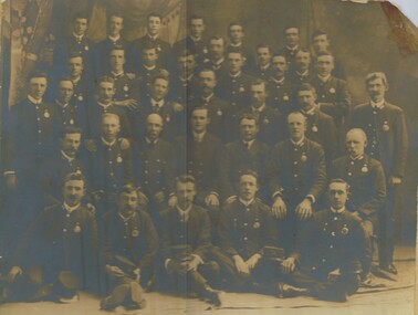
Photograph - CONDUCTORS AND DRIVERS - GROUP PHOTOGRAPH, 1905 or 1906
Photograph - black and white. Written on the back of photo - H.H.Morgan. Auckland, N.Z. 27/06/55. Bendigo Tramways ___ ___ 1905/1906. Names - Back row - Moncrieff, J.Woods, Bellicina, J.Moncrieff, A.Partridge ??, D.Thomas, Wall, E.Pollard. Next row - James C.Campbell, T.Blake, W.James, G.Closie, J.O'Toole, G.Irvine??, T.Lynch, J.F.O'Halloran. 3rd row from back - W.Waldron, G.Cork, F.Parkinsons, W.Mead, B.A.Irvine, J.Parkinson, Polkinghome, J.F,Kenny. 4th row from back - P.Hayes, A.Holl, R.Strode??, H.H.Morgan, A.E.Ross, J.Johnstone, W.Downs??. Front row - T.Laliff??, T.Lynch Snr, G.Horton, J.Teague, P.Thomas. Information received from handwritten sheet, part of 'Basil Miller Tramway Collection.' 74.466 etc.Kalma, Pall Mall, Bendigo.organization, public utility, bendigo tramways., bendigo tramways. group conductors and drivers. -
 Moorabbin Air Museum
Manual (Item) - Specification Engineering For Nomad Utility Aircraft
Description: SUPERSEDES AAP 7211.016-1, PUBLISHED 6/4/1977. 130 pages. Published by RAAF. Published 1/10/1981. DI(AF) AAP 7211.016-1. Nomad N22 Mk.1 Aircraft Flight Manual (1981) Level of Importance: World. -
Moorabbin Air Museum
Document (item) - CAC History - Army Application of the De Havilland Utility Light Aircraft
-
Whitehorse Historical Society Inc.
Book, Vermont and us, 2000
Vermont resident, Joan Nethercote writes on Vermont, families, life and anecdotes, with photos.Vermont resident, Joan Nethercote writes on Vermont, families, life and anecdotes, with photos.Vermont resident, Joan Nethercote writes on Vermont, families, life and anecdotes, with photos.nethercote, joan, nethercote, viv, livermore family, vermont, ballantyne, janet, winswood, vermont, public utilities, giles family, tilson, clive, tilson, clive (mrs), webster family, mckeon, thomas (rev), mckeon hall, cuttle family, wills family, d'arcy family, sport, schools, churches, transport, orchards, scout groups, world war 1939-1945, st lukes anglican church, vermont -
 Whitehorse Historical Society Inc.
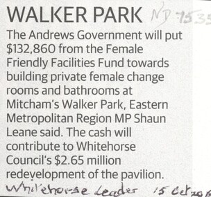
Article, Walker Park, 2018
The State government will contribute towards building female change rooms at Walker Park, Mitcham.The State government will contribute towards building female change rooms at Walker Park, Mitcham.The State government will contribute towards building female change rooms at Walker Park, Mitcham.walker park, mitcham, city of whitehorse, public utilities -
 Whitehorse Historical Society Inc.
Article, Public Loo Finally Opens, 2018
A Disabled Toilet at Blackburn Railway Station is finally open for use.public utilities, toilet block, disabled, level crossing removal authority, blackburn railway station -
 Lakes Entrance Historical Society
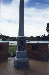
Photograph, Wendy Price, 1990c
Colour photograph of the Lakes Entrance War Memorial on Marine Parade, Lakes Entrance Victoriapublic utilities -
 Lakes Entrance Historical Society
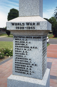
Photograph, Wendy Price, 1990c
Colour photograph of the Lakes Entrance War Memorial on Marine Parade, Lakes Entrance Victoriapublic utilities -
 Lakes Entrance Historical Society
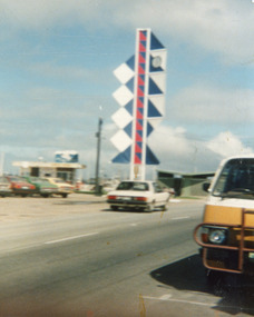
Photograph, 1988c
colour photo showing eastern view of Bi-Centenial clock Lakes Entrance Victoriajetties, public utilities -
 Lakes Entrance Historical Society
Photograph, 1988c
colour photo showing western view of Bi-Centenial clock Lakes Entrance Victoriajetties, public utilities -
Moorabbin Air Museum
Manual (Item) - Detailed Spec. for Nomad Light Utility, RAAF SPEC. ENGINEERING
-
Moorabbin Air Museum
Manual (Item) - Piper Aztec Service Manual Fuel System Instruments Electrical Electronics Heating and Ventilation Accessories and Utilities
-
 Bayside Gallery - Bayside City Council Art & Heritage Collection
Sculpture, Margaret Baskerville, Sir Thomas Bent, 1913
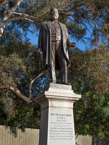
Arguably Margaret Baskerville’s most famous work, the bronze statue of politician and land speculator Sir Thomas Bent was Baskerville’s first public commission and a significant turning point in her career. Originally located in the centre of the Nepean Highway, in Brighton, it became somewhat of signpost for many Melbournians until it was relocated to the corner of Bay Street in 1980.The statue of Sir Thomas Bent is of historic and social significance to the State of Victoria. The statue is historically significant for commemorating Bent's long, active and infamous political career in Victoria. He was responsible for many important speculative ventures both within his electorate and in the wider context of Victoria. Although not without thought for personal gain, Bent was a committed advocate of public utilities, railways, roads, tramways and gasworks. The statue is historically significant as the first large public commission given to a woman sculptor in Victoria. This work helped the sculptor, Margaret Baskerville, preserve her name as Victoria's first professional woman sculptor. The statue is socially significant as testimony to the late nineteenth century land boom and the financial and political corruption and scandals that accompanied it. https://vhd.heritagecouncil.vic.gov.au/places/12614bronze and granite thomas bent, politician, mayor, premier, bust, sculpture, margaret baskerville, speaker, member of parliament, member of lower house, local government, councillor, brighton, public art, bayside -
 Kew Historical Society Inc
Map, MMBW, MMBW Town of Kew, 1910-21
The Melbourne and Metropolitan Board of Works (MMBW) was established by an act of the Victorian Parliament in 1890 to prepare for and to implement a sewerage and water reticulation system across what was then inner Melbourne, its surrounding and middle distance suburbs, including Kew. The MMBW was disbanded in 1991.The map collection of the Kew Historical Society has at its core the historic maps assembled and originally stored in the City Engineer's Department of the City of Kew. These include maps in a number of scales. The vast majority of maps were produced by the MMBW in the first two decades of the twentieth century, and are solid working maps, backed by linen for durability. These maps are historically significant to Kew, the City of Boroondara and to the history of the development of state utilities in Victoria. A number of the Kew maps have additional details added by former municipal officers, including the levels reached by various floods. As these were working documents, information was added to them long after the period of their initial production and distribution.Early map of the Town of Kew, created after 1910, at a scale 440 ft to 1 inch. The 'assembled' map by the City of Kew Engineer's Department includes scaled down copies of The Melbourne and Metropolitan Board of Works maps, Nos. 39, 40, 64, 65, 66, 67, 68, and 117. The map covers the entirety of the Town of Kew, bordered on its north and west by the River Yarra, by Burke Road in the East and Barkers Road in the south. The map shows the extent of urban development by that time, prominent institutions and the outlines of built structures in the municipality. TOWN OF KEW / SCALE 400 FEET TO 1 INCHmelbourne & metropolitan board of works, mmbw maps, mmbw plans, town of kew, cartography -
 Kew Historical Society Inc
Map, MMBW, MMBW Plan No.39 Kew & Heidelberg, 1900-1910
The Melbourne and Metropolitan Board of Works (MMBW) was established by an act of the Victorian Parliament in 1890 to prepare for and to implement a sewerage and water reticulation system across what was then inner Melbourne, its surrounding and middle distance suburbs, including Kew. The MMBW was disbanded in 1991.The map collection of the Kew Historical Society has at its core the historic maps assembled and originally stored in the City Engineer's Department of the City of Kew. These include maps in a number of scales. The vast majority of maps were produced by the MMBW in the first two decades of the twentieth century, and are solid working maps, backed by linen for durability. These maps are historically significant to Kew, the City of Boroondara and to the history of the development of state utilities in Victoria. A number of the Kew maps have additional details added by former municipal officers, including the levels reached by various floods. As these were working documents, information was added to them long after the period of their initial production and distribution.Early map of part of the Borough of Kew, created in the first decade of the twentieth century, at a scale 160 ft to 1 inch. The map covers what was then the north western section of Kew, bordered on its north by Wills Street and the Kew Lunatic Asylum, in the west by the River Yarra [and the later added Yarra Boulevard] , by Princess Street in the East and Holroyd Street in the south. The map shows the extent of urban development by that time, prominent institutions and the outlines of built structures in the municipality. Contour lines were added in ink to the map at a later stage.MELBOURNE AND METROPOLITAN BOARD OF WORKS / PLAN NO. 39 / KEW & HEIDELBERGmelbourne & metropolitan board of works, mmbw maps, mmbw plans, borough of kew, cartography -
 Kew Historical Society Inc
Map, MMBW, MMBW Plan No.40 Collingwood & Kew, 1900-1910
The Melbourne and Metropolitan Board of Works (MMBW) was established by an act of the Victorian Parliament in 1890 to prepare for and to implement a sewerage and water reticulation system across what was then inner Melbourne, its surrounding and middle distance suburbs, including Kew. The MMBW was disbanded in 1991.The map collection of the Kew Historical Society has at its core the historic maps assembled and originally stored in the City Engineer's Department of the City of Kew. These include maps in a number of scales. The vast majority of maps were produced by the MMBW in the first two decades of the twentieth century, and are solid working maps, backed by linen for durability. These maps are historically significant to Kew, the City of Boroondara and to the history of the development of state utilities in Victoria. A number of the Kew maps have additional details added by former municipal officers, including the levels reached by various floods. As these were working documents, information was added to them long after the period of their initial production and distribution.Early map of part of the Borough of Kew, created in the first decade of the twentieth century, at a scale 160 ft to 1 inch. The map covers what was then the south western section of Kew, bordered on its north by Studley Park Road, in the west by Walmer Street and the River Yarra, by High Street South and Princess Street in the East and Barkers Road in the south. The map shows the extent of urban development by that time, prominent institutions and the outlines of built structures in the municipality. Contour lines and historic flood levels were added in ink to the map at a later stage.MELBOURNE AND METROPOLITAN BOARD OF WORKS / PLAN NO. 40 / COLLINGWOOD & KEWmelbourne & metropolitan board of works, mmbw maps, mmbw plans, borough of kew, cartography -
 Kew Historical Society Inc
Map, MMBW, MMBW Plan No.64 Kew & Heidelberg, 1900-1910
The Melbourne and Metropolitan Board of Works (MMBW) was established by an act of the Victorian Parliament in 1890 to prepare for and to implement a sewerage and water reticulation system across what was then inner Melbourne, its surrounding and middle distance suburbs, including Kew. The MMBW was disbanded in 1991.The map collection of the Kew Historical Society has at its core the historic maps assembled and originally stored in the City Engineer's Department of the City of Kew. These include maps in a number of scales. The vast majority of maps were produced by the MMBW in the first two decades of the twentieth century, and are solid working maps, backed by linen for durability. These maps are historically significant to Kew, the City of Boroondara and to the history of the development of state utilities in Victoria. A number of the Kew maps have additional details added by former municipal officers, including the levels reached by various floods. As these were working documents, information was added to them long after the period of their initial production and distribution.Early map of part of the Borough of Kew, created in the first decade of the twentieth century, at a scale 160 ft to 1 inch. The map covers what was then the northern most part of Kew, bordered on its north and west by the Yarra River, in the East by Connor's Creek and by the Asylum in the south. The map shows the extent of urban development by that time, prominent institutions and the outlines of built structures in the municipality. Contour lines and historic flood levels were added in ink to the map at a later stage.MELBOURNE AND METROPOLITAN BOARD OF WORKS / PLAN NO. 64 / KEW & HEIDELBERGmelbourne & metropolitan board of works, mmbw maps, mmbw plans, borough of kew, cartography -
 Kew Historical Society Inc
Map, MMBW, MMBW Plan No.65 Kew & Heidelberg, 1900-1910
The Melbourne and Metropolitan Board of Works (MMBW) was established by an act of the Victorian Parliament in 1890 to prepare for and to implement a sewerage and water reticulation system across what was then inner Melbourne, its surrounding and middle distance suburbs, including Kew. The MMBW was disbanded in 1991.The map collection of the Kew Historical Society has at its core the historic maps assembled and originally stored in the City Engineer's Department of the City of Kew. These include maps in a number of scales. The vast majority of maps were produced by the MMBW in the first two decades of the twentieth century, and are solid working maps, backed by linen for durability. These maps are historically significant to Kew, the City of Boroondara and to the history of the development of state utilities in Victoria. A number of the Kew maps have additional details added by former municipal officers, including the levels reached by various floods. As these were working documents, information was added to them long after the period of their initial production and distribution.Early map of part of the Borough of Kew, created in the first decade of the twentieth century, at a scale 160 ft to 1 inch. The map covers what was then the south central part of Kew, bordered on its north by Malmsbury Street, in the west by Florence Avenue, in the south by Barkers Road, and in the east by Princess Street. The map shows the extent of urban development by that time, prominent institutions and the outlines of built structures in the municipality. Contour lines were added in ink to the map at a later stage.MELBOURNE AND METROPOLITAN BOARD OF WORKS / PLAN NO. 65 / KEW & HEIDELBERGmelbourne & metropolitan board of works, mmbw maps, mmbw plans, borough of kew, cartography -
 Kew Historical Society Inc
Map, MMBW, MMBW Plan No.66 Kew, 1900-1910
The Melbourne and Metropolitan Board of Works (MMBW) was established by an act of the Victorian Parliament in 1890 to prepare for and to implement a sewerage and water reticulation system across what was then inner Melbourne, its surrounding and middle distance suburbs, including Kew. The MMBW was disbanded in 1991.The map collection of the Kew Historical Society has at its core the historic maps assembled and originally stored in the City Engineer's Department of the City of Kew. These include maps in a number of scales. The vast majority of maps were produced by the MMBW in the first two decades of the twentieth century, and are solid working maps, backed by linen for durability. These maps are historically significant to Kew, the City of Boroondara and to the history of the development of state utilities in Victoria. A number of the Kew maps have additional details added by former municipal officers, including the levels reached by various floods. As these were working documents, information was added to them long after the period of their initial production and distribution.Early map of part of the Borough of Kew, created in the first decade of the twentieth century, at a scale 160 ft to 1 inch. The map covers what was then the south eastern part of Kew, bordered on its north by Adeney Avenue, in the west by Sackville Street, in the south by Barkers Road, and in the east by Burke Road. The map shows the extent of urban development by that time, prominent institutions and the outlines of built structures in the municipality. Contour lines were added in ink to the map at a later stage.MELBOURNE AND METROPOLITAN BOARD OF WORKS / PLAN NO. 66 / KEW melbourne & metropolitan board of works, mmbw maps, mmbw plans, borough of kew, cartography -
 Kew Historical Society Inc
Map, MMBW, MMBW Plan No.67 Kew, 1900-1910
The Melbourne and Metropolitan Board of Works (MMBW) was established by an act of the Victorian Parliament in 1890 to prepare for and to implement a sewerage and water reticulation system across what was then inner Melbourne, its surrounding and middle distance suburbs, including Kew. The MMBW was disbanded in 1991.The map collection of the Kew Historical Society has at its core the historic maps assembled and originally stored in the City Engineer's Department of the City of Kew. These include maps in a number of scales. The vast majority of maps were produced by the MMBW in the first two decades of the twentieth century, and are solid working maps, backed by linen for durability. These maps are historically significant to Kew, the City of Boroondara and to the history of the development of state utilities in Victoria. A number of the Kew maps have additional details added by former municipal officers, including the levels reached by various floods. As these were working documents, information was added to them long after the period of their initial production and distribution.Early map of part of the Borough of Kew, created in the first decade of the twentieth century, at a scale 160 ft to 1 inch. The map covers what was then the north central part of Kew, bordered on its north by the Outer Circle Railway Spruzen and Beresford Avenues, in the west by Princess Street, in the south by High Street, and in the east by (about) Belford Road. The map shows the extent of urban development by that time, prominent institutions and the outlines of built structures in the municipality. Contour lines were added in ink to the map at a later stage.MELBOURNE AND METROPOLITAN BOARD OF WORKS / PLAN NO. 67 / KEW melbourne & metropolitan board of works, mmbw maps, mmbw plans, borough of kew, cartography -
 Kew Historical Society Inc
Map, MMBW, MMBW Plan No.68 Kew, 1900-1910
The Melbourne and Metropolitan Board of Works (MMBW) was established by an act of the Victorian Parliament in 1890 to prepare for and to implement a sewerage and water reticulation system across what was then inner Melbourne, its surrounding and middle distance suburbs, including Kew. The MMBW was disbanded in 1991.The map collection of the Kew Historical Society has at its core the historic maps assembled and originally stored in the City Engineer's Department of the City of Kew. These include maps in a number of scales. The vast majority of maps were produced by the MMBW in the first two decades of the twentieth century, and are solid working maps, backed by linen for durability. These maps are historically significant to Kew, the City of Boroondara and to the history of the development of state utilities in Victoria. A number of the Kew maps have additional details added by former municipal officers, including the levels reached by various floods. As these were working documents, information was added to them long after the period of their initial production and distribution.Early map of part of the Borough of Kew, created in the first decade of the twentieth century, at a scale 160 ft to 1 inch. The map covers what was then the north central part of Kew, bordered in the north by Oak Avenue, in the west by the Yarra River and Connor's Creek, in the south by Beresford and Carnegie Avenues, and in the east by Glass's Creek and Burke Road. The map shows the extent of urban development by that time, prominent institutions and the outlines of built structures in the municipality. Contour lines and the levels of historic floods were added in ink to the map at a later stage.MELBOURNE AND METROPOLITAN BOARD OF WORKS / PLAN NO. 68 / KEW melbourne & metropolitan board of works, mmbw maps, mmbw plans, borough of kew, cartography -
 Kew Historical Society Inc
Map, MMBW, MMBW Plan No.117 Heidelberg & Kew, 1900-1910
The Melbourne and Metropolitan Board of Works (MMBW) was established by an act of the Victorian Parliament in 1890 to prepare for and to implement a sewerage and water reticulation system across what was then inner Melbourne, its surrounding and middle distance suburbs, including Kew. The MMBW was disbanded in 1991.The map collection of the Kew Historical Society has at its core the historic maps assembled and originally stored in the City Engineer's Department of the City of Kew. These include maps in a number of scales. The vast majority of maps were produced by the MMBW in the first two decades of the twentieth century, and are solid working maps, backed by linen for durability. These maps are historically significant to Kew, the City of Boroondara and to the history of the development of state utilities in Victoria. A number of the Kew maps have additional details added by former municipal officers, including the levels reached by various floods. As these were working documents, information was added to them long after the period of their initial production and distribution.Early map of part of the Borough of Kew, created in the early twentieth century, at a scale 160 ft to 1 inch. The map covers what was then the north eastern part of Kew showing the natural landscape and limited development on the south side of the Yarra River. In the Kew section, south of the river, the land is occupied currently by the Greenacres and Kew Golf Clubs. The map shows the extent of urban development by that time and the outlines of the few built structures in the municipality. The height above sea level of all parts of the landscape are indicated numerically in feet. Contour lines and the levels of historic floods were added in ink to the map at a later stage. MELBOURNE AND METROPOLITAN BOARD OF WORKS / PLAN NO. 117 / HEIDELBERG & KEW melbourne & metropolitan board of works, mmbw maps, borough of kew, cartography, mmbw plan no. 117, kew (vic.) -- maps, heidelberg (vic.) -- maps -
 Kew Historical Society Inc
Map, MMBW, River Yarra Beautification Schemes, c.1913
The Melbourne and Metropolitan Board of Works (MMBW) was established by an act of the Victorian Parliament in 1890 to prepare for and to implement a sewerage and water reticulation system across what was then inner Melbourne, its surrounding and middle distance suburbs, including Kew. The MMBW was disbanded in 1991.The map collection of the Kew Historical Society has at its core the historic maps assembled and originally stored in the City Engineer's Department of the City of Kew. These include maps in a number of scales. The vast majority of maps were produced by the MMBW in the first two decades of the twentieth century, and are solid working maps, backed by linen for durability. These maps are historically significant to Kew, the City of Boroondara and to the history of the development of state utilities in Victoria. A number of the Kew maps have additional details added by former municipal officers, including the levels reached by various floods. As these were working documents, information was added to them long after the period of their initial production and distribution.Map of the City of Kew showing part of the River Yarra Beautification Schemes. The map shows development to date and the flood levels reached in 1923 and 1924. This map may have been adapted from an earlier map, as most development in central Kew and Studley Park had occurred by this date yet numerous streets are not represented. Public buildings and institutions are clearly represented and named on the map as are significant public transport infrastructure (eg the Outer Circle railway).MELBOURNE AND METROPOLITAN BOARD OF WORKS / RIVER YARRA BEAUTIFICATION SCHEMES / SCHEME / SCALE 10 CHAINS TO AN INCHmelbourne & metropolitan board of works, mmbw maps, mmbw plans, city of kew, flood levels -- kew (vic.), cartography