Showing 1116 items matching "william robert."
-
 Warrnambool and District Historical Society Inc.
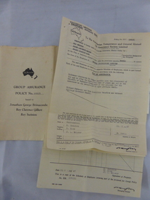
Financial record - Document, Swinton Employee Assurance, 1947
... Following William Swinton’s death his son Robert became the first managing director of Swintons Pty Ltd. ...Following William Swinton’s death his son Robert became the first managing director of Swintons Pty Ltd. ...These documents come from the Warrnambool business of Swintons Pty Ltd. They are 1947 life insurance documents related to the insuring of Swinton employees, payable following retirement or death. William and Ann Swinton migrated to Australia in 1854 and for a decade William Swinton worked as a builder and carpenter in the Warrnambool area, erecting many buildings, including the Wangoom Presbyterian Church. In 1865 he opened a store in Timor Street, Warrnambool, selling groceries, glassware, china and hardware. By 1888 the business was known as William Swinton and Sons. Branch stores were opened in Cudgee, Nullawarre, Wangoom, West Warrnambool and South Warrnambool. Following William Swinton’s death his son Robert became the first managing director of Swintons Pty Ltd. In 1934 the business split with George Swinton and Sons selling furnishings, clothing and glassware and Swintons Pty Ltd selling seeds, produce and hardware. Today the Swinton family still operates a furniture and bedding store in Timor Street. These documents are of interest as they contain information on the insurance policies taken out by Swintons Pty Ltd on behalf of their employees. The current Swinton business in Timor Street is the oldest family business in Warrnambool and, with the name Swinton associated with businesses in Timor Street for 152 years, it is amongst the oldest family business in Australia. .1 This is a document in four parts concerning the insurance for employees of Swintons Pty Ltd. in 1947. The pages are copies and have both printed and typed material .2 This is a policy document, a sheet of paper folded in two to make four pages of printed and typed material. It is a copy. The first page has a red seal.swinton family warrnambool, history of warrnambool -
 Warrnambool and District Historical Society Inc.
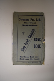
Leaflet, Kaye & Son, Printers, Swintons, Mid 20th century
... After William Swinton’s death, his son, Robert, became the first managing director of Swintons Pty Ltd. ...After William Swinton’s death, his son, Robert, became the first managing director of Swintons Pty Ltd. ...This leaflet was a promotion tool of the Warrnambool business, Swintons Pty Ltd. It was used to insert stamps given by the firm when goods were purchased. When the pages were filled with 200 stamps the owner was given two shillings and sixpence in cash. It was a reward to the regular customer. William and Ann Swinton migrated to Australia in 1854 and for a decade William Swinton worked as a builder and carpenter in the Warrnambool area. In 1865 he opened a store in Timor Street, Warrnambool selling groceries, hardware, glassware and china. By 1888 the business was known as William Swinton and Sons. Branch stores were opened in Cudgee, Nullawarre, Wangoom, West Warrnambool and South Warrnambool. After William Swinton’s death, his son, Robert, became the first managing director of Swintons Pty Ltd. In 1934 the business split, with George Swinton and Sons selling furnishings, clothing and glassware and Swintons Pty Ltd selling groceries, seeds, produce and hardware. Today the Swinton family still operates a furniture and bedding store in Timor Street. This leaflet is of interest as an example of the advertising practices carried out by the firm of Swintons Pty Ltd, an important business in Warrnambool for many years. The current Swinton business in Timor Street, Warrnambool is the oldest family business in Warrnambool and, with the name Swinton associated with Timor Street businesses for 152years, it is amongst the oldest family businesses in Australia.This is a leaflet with a grey cover and four pages inside. The cover has dark blue printing and the pages have black printing and are ruled into 15 spaces. There are over 100 blue stamps stuck onto the ruled spaces. The cover is tattered at the edges and one stamp is loose.‘Swintons Pty Ltd Timor Street Warrnambool Provision, Seed and Hardware Merchants Blue Cash Coupons Bank Book’ swinton family businesses, warrnambool, history of warrnambool -
 Warrnambool and District Historical Society Inc.
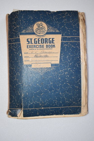
Exercise Book (Swinton), Book, 1947-1950
... After William Swinton’s death his son Robert became the first managing director of Swintons Pty Ltd. ...After William Swinton’s death his son Robert became the first managing director of Swintons Pty Ltd. ...This exercise book contains letters, mostly aerogrammes, sent by people in England during the years 1947 to 1950. They are letters of thanks for the food parcels sent to these people by the staff of George Swinton and Sons of Timor Street Warrnambool. The letters give details of the contents of the parcels, the situation with the families receiving the parcels and the effects of the food rationing and shortages in England immediately after World War Two. The name ‘H.C.Thomson’ on the front of the book refers to Helen Thomson, a staff member of George Swinton & Sons in charge of the food parcel distribution. William and Ann Swinton came to the Warrnambool area in 1854 and William opened a groceries, hardware, china and glassware store in Timor Street in 1865. After William Swinton’s death his son Robert became the first managing director of Swintons Pty Ltd. In 1934 the business split with Swintons Pty Ltd selling seeds, produce and hardware and George Swinton and Sons selling furnishings, clothing and glassware. Today the Swinton family still operates a furniture and bedding store in Timor Street, making it one of the oldest family businesses in Australia. This exercise book containing letters sent from England in response to the receipt of food parcels from the staff of George Swinton & Sons of Warrnambool is of considerable significance. The letters form a splendid social history of the situation in England after World War Two, especially for the elderly and the unemployed. They also are a reminder of the charity work undertaken by the staff of George Swinton & Sons 70 years ago. This was a prominent family business in Warrnambool (and continues in another form to this day). This is an exercise book with brown binding and a blue front cover with an image of St George, blue printing and a handwritten name and some other handwritten material which is not decipherable. The back cover has blue printing. Pasted on to the pages are handwritten letters and cards, mostly four to a page. Most of the letters are aerogrammes and some have stamps. Some pages contain addresses of families in England. There are some loose sheets.St. George Exercise Book Name… H.C.Thomson Grade.. School.. Swinton & Sons Timor St. W’bool Victoriageorge swinton & sons, history of warrnambool -
 Warrnambool and District Historical Society Inc.
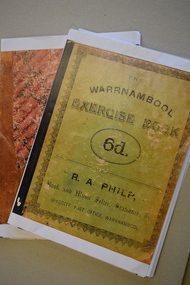
Booklet - School Exercise Books, late 19th century
... The second exercise book was produced in 1881 by Catherine Vickers, the daughter of Robert and Sara Vickers. She was born in 1867, married William Yates in 1901 and died in Mortlake in 1943....The second exercise book was produced in 1881 by Catherine Vickers, the daughter of Robert and Sara Vickers. She was born in 1867, married William Yates in 1901 and died in Mortlake in 1943. ...school exercise book.1 These are 35 photocopied pages of an exercise book. The cover is green with black writing. The pages contain handwritten material and mathematical exercises and maps. .2 These are 17 photocopied pages of a exercise book. The cover is brown with a mottled pattern. The pages contain handwritten material, mathematical exercises and maps. fictionschool exercise bookschool exercise books, panmure state school, vickers family of panmure -
 Warrnambool and District Historical Society Inc.
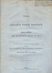
Document, Allan’s Ford Bridge 1852, 1852
... The correspondence dates from October 1850 to February 1852 and includes letters and reports from Melbourne Government employees such as Robert Hoddle, Chief Surveyor, David Lennox, Superintendent of Bridges and Lieutenant – Governor Charles La Trobe. The correspondence from local settlers included the names of William and John Allan, John Davidson and James Coulstock. ...The correspondence dates from October 1850 to February 1852 and includes letters and reports from Melbourne Government employees such as Robert Hoddle, Chief Surveyor, David Lennox, Superintendent of Bridges and Lieutenant – Governor Charles La Trobe. The correspondence from local settlers included the names of William and John Allan, John Davidson and James Coulstock. ...This is an original Victorian Government document containing the printed version of 37 reports and letters regarding the building of the first Allansford bridge completed early in 1852. The correspondence dates from October 1850 to February 1852 and includes letters and reports from Melbourne Government employees such as Robert Hoddle, Chief Surveyor, David Lennox, Superintendent of Bridges and Lieutenant – Governor Charles La Trobe. The correspondence from local settlers included the names of William and John Allan, John Davidson and James Coulstock. The correspondence shows that some settlers in the Warrnambool/Port Fairy district wanted a portion of the Government allocated funds spent on the local roads and bridges in other locations. The 1852 Allansford bridge cost £480 and was replaced in 1870. This document has strong historical significance as it relates to one of the earliest State government works in the district and records the public imput into the decision.. It contains opinions and correspondence between a number of early settlers in the district at the time.Grey/blue paper document with black text. 21 pages plus 4 page index at back.allan's ford 1852, allansford bridge, allansford, history of allansford, warrnambool -
 Warrnambool and District Historical Society Inc.
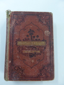
Book, Martin Rattler, 1876
... The Head Teacher, William Bryant was at the school until 1894. (Blanch) Edith Newton was born in 1868, the eighth child of Robert and Mary Newton. ...The Head Teacher, William Bryant was at the school until 1894. (Blanch) Edith Newton was born in 1868, the eighth child of Robert and Mary Newton. ...This book, by the well-known author R.M.Ballantyne, was awarded to Edith Newton in 1877 when she was a pupil at the Warrnambool State School. This school was opened on August 1st 1876 when the National School in Warrnambool closed and most of the pupils of other denominational schools in Warrnambool at the time moved to the new State School. The Head Teacher, William Bryant was at the school until 1894. (Blanch) Edith Newton was born in 1868, the eighth child of Robert and Mary Newton. Robert Newton was a Rate Collector, Borough Inspector and Manager of the Town Common in Warrnambool. It is noted that the prize received by Edith Newton was an adventure book mostly appealing to male readers. This book is significant because it is connected with important elements in Warrnambool in 1877 – the school, Warrnambool State School, the pupil, Edith Newton and the Head Teacher, William Bryant,This is a hard cover book of 330 pages. It has a dark red cover with etched ornamental borders and patterns and an image of a jungle scene on the front cover and on the spine. The title and author’s name are in gold lettering. At the heading of each chapter there is an ornamental scroll and there are several black and white sketches throughout the pages. There are blue stamps of the Warrnambool & District Historical Society at the front and back of the book and a school plate label attached to the inside front cover. The spine is partly detached and torn and the cover is very worn and water or mould damaged. A letter from the donor accompanies the book. ‘Warrnambool State School, No. 1743, Prize Awarded to Edith Newton, 4th Class, Divn. 111, for Home Exercises, 19th December 1877, W.Bryant, Head Teacher.’ warrnambool state school, history of warrnambool, william bryant, edith newton -
 Warrnambool and District Historical Society Inc.
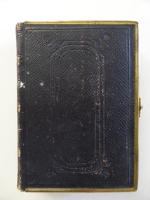
Book, Bible (in Welsh), 1868
... In 1874 she married William Jones of Warrnambool and became a stepmother to Robert Jones who was to become the owner of the property The Union, near Woolsthorpe. ...In 1874 she married William Jones of Warrnambool and became a stepmother to Robert Jones who was to become the owner of the property The Union, near Woolsthorpe. ...This Welsh Bible belonged to Ellen Hughes who was Welsh-speaking and the daughter of a farmer from Caernarfonshire, Wales. In 1874 she married William Jones of Warrnambool and became a stepmother to Robert Jones who was to become the owner of the property The Union, near Woolsthorpe. Robert’s daughters, Gwen and Edna Jones, gave this Bible to the Warrnambool and District Historical Society. They were both members of the Society. This book is of great importance as a beautiful memento of the 19th century when the Welsh Calvinistic tradition was strong in the Warrnambool district and a Gaelic church was operating in Woodford and services in Gaelic services were held regularly in Warrnambool. This is a hard cover book with a brown leather cover with gold metal edging and a gold clasp. The cover has embossed patterns on the front back and spine. The pages have gilt edges. The text is in the Welsh language and is presented in two columns per page. There is one blue stamp of the Warrnambool and District Historical Society on the first page. The inscription is handwritten in black ink. ‘Presented to Miss Ellen Hughes by her wellwishers Hugh and Kate Pritchard, Llanfairfechan, July 14th 1871’ ellen hughes, gaelic church, woodford, history of warrnambool, the union -
 Warrnambool and District Historical Society Inc.
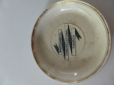
Plate, Warrnambool Congregational Church, Early 20th century
... The Warrnambool Congregational Church was established in 1862 when Robert Winton and Thomas Nayler set up a meeting to discuss the possibility of establishing an Independent Church in Warrnambool. The first minister was William...The Warrnambool Congregational Church was established in 1862 when Robert Winton and Thomas Nayler set up a meeting to discuss the possibility of establishing an Independent Church in Warrnambool. The first minister was William ...This plate comes from the Congregational Church in Warrnambool. It was probably part of a set of crockery used by church members at social events. The Warrnambool Congregational Church was established in 1862 when Robert Winton and Thomas Nayler set up a meeting to discuss the possibility of establishing an Independent Church in Warrnambool. The first minister was William Pentland and the first church was opened in 1864 in Liebig Street. Samuel Nettleton was a notable early church member, being Superintendent of the Sunday School for 60 years. A new church was opened in Henna Street in 1940. In 1973 the Congregational Church merged with the Methodist Church to form the Uniting Church in 1977. In 1976 the former Congregational Church in Henna Street was sold to the Salvation Army. This plate is of interest as a memento of the former Congregational Church in Warrnambool. In the early to mid 20th century this church was a strong and influential force in the Warrnambool community. This is a cream-coloured dinner plate made of china. The gold bands around the edge of the plate are now almost obliterated. The lettering in the middle of the plate is black and white. The plate has several chips on the edge and is somewhat stainedWarrnambool Congregational Church’warrnambool congregational church -
 Warrnambool and District Historical Society Inc.
Book, Thalaba the destroyer Vol 1, 1821
... William Cassady...John Bland...John Cowtan...Thalaba the Destroyer...warrnambool...poem thalaba the Destroyer...19th century poems...robert...William Anderson, Rosemount William Cassady John Bland John Cowtan Thalaba the Destroyer warrnambool poem thalaba the Destroyer 19th century poems robert southey books ‘Wm. ...This book was written in 1801 in an epic poem form. It is unrhymed. It falls into the category of fantasy. The original owner of this book seems to have been John Bland. He is most important in the early history of Port Fairy and had a business in Port Fairy with John Cowtan (corn millers and general merchants). The Cowtans originally had land in the vicinity of the Cassady property of Boughton, Merri River (in Caramut Road near Cassady’s Bridge today) and were related by marriage to the Cassadys. A later owner of the book was William Anderson whose father came to the Yangery district in 1854 and established the property of Rosemount and William remained in this area until his death in 1909. The Andersons were related by marriage to the Cassadys and this book came to us following a clearance sale at the Cassady property, Boughton. This book is of great interest less for its literary content than for its ownership which probably dates back to the 1840s. It is associated with the families of Bland, Cowtan, Cassady and Anderson, all early settlers in Warrnambool and district.This is a brown leather-covered book of 271 pages. The cover has gold decorative borders and patterns and gold lettering. The pages are gilt-edged. The book is the fourth edition of volume one of a Robert Southey poem and has a Preface and Books 1 to 5 with Notes. The inscriptions are handwritten in black ink. One signature has not been deciphered. ‘Wm. Anderson’ ‘John Bland’ william anderson,, rosemount, william cassady, john bland, john cowtan, thalaba the destroyer, warrnambool, poem thalaba the destroyer, 19th century poems, robert southey books -
 Warrnambool and District Historical Society Inc.
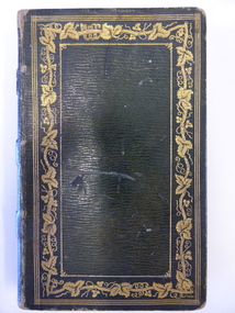
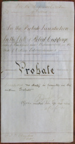
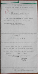
Document - Robert Cuppage Probate 1904, 1904
... It will be useful to researchers robert cuppage ernest chambers warrnambool bushfield tait collection In the Supreme Court of Victoria; In the Probate Jurisdiction; In the Will of Robert Cuppage late of Bushfield near Warrnambool in the State of Victoria Labourer deceased This is a piece of cream-coloured parchment paper folded in two and containing handwritten material on four sides of the paper. It contains details on the Will and Probate of William ...Tait collection: item 24 of 62 This is a 1904 document giving information on the Will and Probate of Robert Cuppage. He was a labourer who lived at Woodford and he and his wife, Jane received much sympathy following the deaths from diphtheria of five of their children in 1866. Charlotte (3) and Elizabeth (14) died on 26th August, Robert (6) died on 27th August, Hanne (8) died on 30th August and George (15) died on 14th September. Jane Cuppage died in 1889 and Robert died in December 1903. He left real estate to the value of £240 and personal estate to the value of £5 to his daughter, Margaret Trigg. Ernest Chambers had legal offices in Warrnambool, Port Fairy and Koroit at the end of the 19th century and the beginning of the 20th century. This document was in his possession and it was passed down to successive lawyers occupying the legal offices in Kepler Street and located in this building in 2014 and passed on the Warrnambool and District Historical Society. This is an interesting document as it gives the Will and Probate details of a well-known Woodford resident in the 19th century. It will be useful to researchersThis is a piece of cream-coloured parchment paper folded in two and containing handwritten material on four sides of the paper. It contains details on the Will and Probate of William Charlesworth, 1904. The seal of the Supreme Court of Victoria is attached with green ribbon and there are two purple stamps, one from the Master in Equity of the Supreme Court in Melbourne and the other from the Bank of Australasia in Warrnambool. The document is somewhat stained on one side but the writing is legible.In the Supreme Court of Victoria; In the Probate Jurisdiction; In the Will of Robert Cuppage late of Bushfield near Warrnambool in the State of Victoria Labourer deceasedrobert cuppage, ernest chambers, warrnambool, bushfield, tait collection -
 Warrnambool and District Historical Society Inc.
Document, Thomas Smith Probate 1880
... Robert and Mary Smith) held the licence of the hotel until 1880. A codicil to the will gave Mary Smith, Thomas’ daughter, the hotel land and building. This hotel closed in 2011. Thomas Smith signed the original will with a cross (his mark). Other names mentioned in the probate document are Frederick Wilkinson, Master-in-Equity, Ernest Chambers, Solicitor, John Drayton, Clerk to E. Chambers, William...Robert and Mary Smith) held the licence of the hotel until 1880. A codicil to the will gave Mary Smith, Thomas’ daughter, the hotel land and building. This hotel closed in 2011. Thomas Smith signed the original will with a cross (his mark). Other names mentioned in the probate document are Frederick Wilkinson, Master-in-Equity, Ernest Chambers, Solicitor, John Drayton, Clerk to E. Chambers, William ...Tait collection: item 33 of 62 This probate document gives details of the will of Thomas Smith, a farmer in the Wangoom district who was a pioneer settler, having arrived in the area about 1848. He erected the Shamrock Hotel in Dennington in 1868 and it was opened for business in 1869 with David Duffy as the first licensee. Thomas Smith was the licensee in 1870 and members of his family (Cornelius, Robert and Mary Smith) held the licence of the hotel until 1880. A codicil to the will gave Mary Smith, Thomas’ daughter, the hotel land and building. This hotel closed in 2011. Thomas Smith signed the original will with a cross (his mark). Other names mentioned in the probate document are Frederick Wilkinson, Master-in-Equity, Ernest Chambers, Solicitor, John Drayton, Clerk to E. Chambers, William Ardlie, Senior, Solicitor, Thomas Goodall, Clerk to William Ardlie, Richard Sheldrick, Clerk to William Ardlie, Walter Davies, Stationer.This is a significant document as Thomas Smith was a prominent owner of land, especially in the Dennington area. The Shamrock Hotel in Dennington was built by Smith and still owned by him when he died in 1880. The will gives important details of the estate of Thomas Smith and adds to our knowledge of his life and work. Document – Probate, 1880/1907 - the Will and Codicil of Thomas Smith, Farmer of Dennington The will has six ruled paper pages of typewritten material. Each page has printed ruled red lines top, bottom and sides and all are tied with green corded string. There are handwritten corrections and signatures, including those of Ernest Chambers, Solicitor of Warrnambool and John Drayton, Clerk to E. Chambers.Thomas Smith Shamrock Hotel, Dennington Ernest Chambers, Solicitor thomas smith wangoom 1848, shamrock hotel dennington, warrnambool history, thomas smith 1880 -
 Bendigo Military Museum
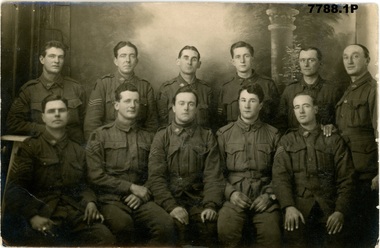
Postcard - PHOTOGRAPHIC POSTCARDS WW1, Edgar Dawson collection : Battalion comrades
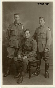
... William Tamlyn Curnow, 5078, 57th Btn 4. Photographic portrait of "Jim", 5. Photographic portrait of Septimus Fletcher, 4485, 57th Btn 6. Photographic portrait of Robert...William Tamlyn Curnow, 5078, 57th Btn 4. Photographic portrait of "Jim", 5. Photographic portrait of Septimus Fletcher, 4485, 57th Btn 6. Photographic portrait of Robert ...This six-postcard group is the second in a series of records of items in the collection of Edgar Dawson DCM. Dawson was the Regimental Sergeant Major of 57th Battalion, AIF. The 57th had a company of men largely from Bendigo and Eaglehawk. These postcards are from his personal album. Many are annotated in Dawson's hand with explanatory notes on the subject. Refer to Cat No 893 for his service details. Items originally in album cat. no. 207P Service details available through the NAA. Collection of six black and white postcards: 1. Photographic portrait from left William George Saville 4182, Alexander Pollock 3587 57th Btn, and unidentified trooper, possible 4th Light Horse Regiment. 2. Photographic portrait of Light Horse trooper. 3. Photographic portrait of William Tamlyn Curnow, 5078, 57th Btn 4. Photographic portrait of "Jim", 5. Photographic portrait of Septimus Fletcher, 4485, 57th Btn 6. Photographic portrait of Robert Gamble, 4644, 57th Btn 2. Card is addressed to "1904 L.Cpl W.W. Martin, D Cpy 57th Batt". Martin was 2150, KIA 26th September 1917. 3. On front "Sincerely, W. T. Curnow". On verso, "To Hec, from his old pal Curnow Sgt" 'Hec' was Dawson's nickname. 4. On front "Yours sincerely Jim". On verso, card addressed "350 Pte Melen, R. C., 15th Field Ambulance, via Manners St Maryborough Victoria" The 15th Field Ambulance Cpy, supported the 57th and other battalions of the 15th Brigade. 5. On verso "This is an Eaglehawk boy Septimus Fletcher, he came over with me and was with us a long time, but is on Division now" 6. On verso "This is our signal Cpl wearing his military medal for keeping communication at Bullecourt". Gamble won the MM for his actions 13th May 1917.57th battalion, postcards, album dawson dcm, edgar dawson dcm -
 Bendigo Military Museum
Postcard - PHOTOGRAPHIC POSTCARDS WW1, Edgar Dawson Collection : Sergeants of the 57th Battalion group photos
... From left, lower: Ross, Angus John William 4584 Wilkinson, Albert James 4627 Wheaton, Stanley 4631 Shearer, Robert John Lesley 2896 Macken, Charles Anthony 2007 Howard, Ray Septimus 3556 Rogers, Ernest 1764 Harris, Alfred George 1959 Cockram, Louis 955 Short, Stanley 2684 Rex King (number not traced) 2. ...From left, lower: Ross, Angus John William 4584 Wilkinson, Albert James 4627 Wheaton, Stanley 4631 Shearer, Robert John Lesley 2896 Macken, Charles Anthony 2007 Howard, Ray Septimus 3556 Rogers, Ernest 1764 Harris, Alfred George 1959 Cockram, Louis 955 Short, Stanley 2684 Rex King (number not traced) 2. ...This four-postcard group is the ninth in a series of records of items in the collection of Edgar Dawson DCM. Dawson was the Regimental Sergeant Major of 57th Battalion, AIF. C Company of the 57th was composed of men drawn from Echuca, Eaglehawk and Bendigo. The postcards are from his personal album, and many are annotated in Dawson's hand with explanatory notes on the subject. Refer to Cat No 893 for his service details. Items originally in album cat. no. 207P 1. From left, lower: Ross, Angus John William 4584 Wilkinson, Albert James 4627 Wheaton, Stanley 4631 Shearer, Robert John Lesley 2896 Macken, Charles Anthony 2007 Howard, Ray Septimus 3556 Rogers, Ernest 1764 Harris, Alfred George 1959 Cockram, Louis 955 Short, Stanley 2684 Rex King (number not traced) 2. Unidentified group of sergeants, 57th Battalion 3. A Company sergeants, 57th Battalion 4. B company sergeants, 57th Battalion 1. Names on verso 2. "Yours sincerely, J.W. Brown Sgt, 57th Battalion, A.I.F pt address Etonia, Coorigil Road Murrumbeena Victoria" 3. "These are the sergeants of A company of our battalion" 4. "This is B company sergeants of our battalion. The three in front came over on the boat with me" postcards, 57th battalion, edgar dawson dcm -
 Warrnambool and District Historical Society Inc.
Document, Lease agreement 1862 William Melville & Augustus and James Bostock, 1862
... Robert and Rachel Bostock with his mother dying in childbirth with his delivery. He loved working with horses and was close to his brothers Augustus and John. He was the third of the Bostock brothers to marry an Aitkin sister in this case Alice in 1875. He was a commission agent and money lender in Warrnambool. He died in 1919. In the 1860/70’s William...Robert and Rachel Bostock with his mother dying in childbirth with his delivery. He loved working with horses and was close to his brothers Augustus and John. He was the third of the Bostock brothers to marry an Aitkin sister in this case Alice in 1875. He was a commission agent and money lender in Warrnambool. He died in 1919. In the 1860/70’s William ...Augustus Bostock was the 9th child of Robert & Rachael Bostock of Vaucluse Epping Forest, Van Diemen’s Land. He was only 4 years old when his mother died. He along with his brothers, was inspired by his father to seek his fortune in the Western District of Victoria. He arrived around 1850. He married Margaret Aitkin in July 1865. Augustus owned several properties in the district and leased others. He sat on the court of Warrnambool, Mortlake or Hexham as required. He resided at Marramook in Hawkesdale and later moved to Vaucluse in Hopetoun Road Warrnambool, where he died in 1920 at the age of 87. He was involved in many aspects of life in the Western District, racing, cricket, and social activities to name a few. James Bostock was the youngest of Robert and Rachel Bostock with his mother dying in childbirth with his delivery. He loved working with horses and was close to his brothers Augustus and John. He was the third of the Bostock brothers to marry an Aitkin sister in this case Alice in 1875. He was a commission agent and money lender in Warrnambool. He died in 1919. In the 1860/70’s William Melville traded in partnership with William Bayles as merchants in Melbourne and as landholders and leases of land in the Western District Weerangourt with 14192 acres freehold. This lease is for approximately 6000 acres and is for a period of 10 years at 2/9 per acre. This is one of a number of documents which relate to the Bostock family who were one of the most important pioneering families of the Western District. They owned and leased various properties around Warrnambool and were involved in many aspects of social and business life. The document itself is indicative of its time and provides an insight into the details and terms of such documents at the time. Ten page, large sheeted document, handwritten in black ink on blue paper. It has been folded in four. Date and names of people involved on one section.William Melville Augustus Bostock James Bostock.warrnambool, bostock, augustus bostock, james bostock, william melville, lease 1862, -
 Bendigo Military Museum
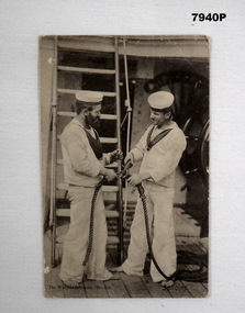
Postcard - POSTCARD - PHOTOGRAPHIC
... Card sent by "Alfred William Baron", No. VX29810, brother of Robert H. Baron, Part of the Cooper Collection....Bendigo Military Museum 37 - 39 Pall Mall Bendigo goldfields Card sent by "Alfred William Baron", No. VX29810, brother of Robert H. Baron, Part of the Cooper Collection. ...Card sent by "Alfred William Baron", No. VX29810, brother of Robert H. Baron, Part of the Cooper Collection.Black and white postcard depicting two sailors in uniform on the deck of a ship. Sailors are working with rope. Handwritten message in back of postcard.Handwritten in pencil on back of postcard: 'To my Dear Sister Myrtle from her loving Brother, Alf xxxxxxxxxxxxx.'cooper collection, alfred w baron, postcard -
 Bendigo Military Museum
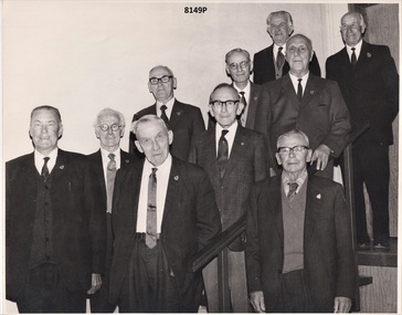
Photograph - RSL 50 YEAR MEMBERS, C. 1972
... Robert Harrowfield Regt No 4954, 8th Bn. Jabez Hopkins Merryman Regt No 1981, 11th Bn & 1st M.G Bn. Bot. William...Robert Harrowfield Regt No 4954, 8th Bn. Jabez Hopkins Merryman Regt No 1981, 11th Bn & 1st M.G Bn. Bot. William ...All the men in the photo were Great War soldiers. On the day of the presentation in 1972 the men were accompanied by their wives or relatives and treated to afternoon tea by the RSL Ladies Auxiliary and entertained by two RSL members George Elliot and George English. Top. Norman McLaren Young Regt No 7595, 13th & 14th Bn's. Thomas Richardson Liddle Regt No 1963, 21st Bn. Centre. Wm Earl Waters Regt No 718, 22nd Bn & 4th Fld Engineers. Robert Harrowfield Regt No 4954, 8th Bn. Jabez Hopkins Merryman Regt No 1981, 11th Bn & 1st M.G Bn. Bot. William Flett Regt No1767, 22nd & 24th Bn's. George Keir Regt No 1374, 13th LH Regt. David Jones Regt No 2670, 57th Bn. Norman Charles Boyle Regt No 1803, 38th Bn. Roy McEwan Johnson Regt No 2671, 57th Bn.Photograph B & W showing a group of 10 men who recieved their 50 year membership Certificates as members of the Bendigo RSL Sub Branch. Photograph was taken on the stairs to the stage in the Main Hall of the Soldiers Memorial Institute Bendigobrsl, smirsl, 50 years, membership, wabrsl -
 Bendigo Military Museum
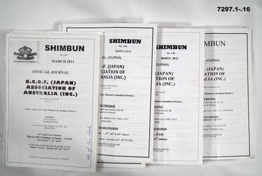
Booklet - BOOKLETS, BCOF, B.C.O.F. (Japan) ASSOCIATION OF AUSTRALIA (INC)
... William McGILVERY, RAAF. Refer Cat No. 7287P for his service details, photos, awards. History Booklets BCOF Front cover, handwritten notes, blue or black ink. 1. 2. 3. 4. 8. 13. 1. "All of this book". 2. "Pages 3,5,7,8,9,13,16,17,19 to 24." 3. "Pages 3,4,12,13, to 23." 4. On paper "Pages 3-8, 10, 16, 19 to 24" 8. "26 mags altogether/ the 2 you have already read" 13. "Jane/Danny/ 9915/ 48/ 04". 19. " Lorraine 0353920942=/Willa McGilvery, PO Box 132/Donald/ 3480/ 03 5497 1724". 20. "My letter to sacked MP Stuart Robert ...Booklets are the - "OFFICIAL JOURNAL/ B.C.O.F. (JAPAN)/ ASSOCIATION OF/ AUSTRALIA (INC)/ Since 1972/ (Navy, Army, Air Force, Women's & Auxilliary Forces)" Please note - name change from "SHIBUM to SHIMBUN' on these booklets. Shinbun and Shimbun - is the correct spelling for the word for newspaper in Japanese. Booklets - items in the collection of Richard William McGILVERY, RAAF. Refer Cat No. 7287P for his service details, photos, awards.SOFT COVER BOOKLET. ALL BOOKLETS - PAPER WITH BLACK PRINT ON FRONT AND BACK. CHRISTMAS ISSUES HAVE DECORATIVE TRIM IN GREEN AND/OR RED PRINT. ILLUSTRATED WITH " BRITISH COMMONWEALTH FORCES" WITH CROWN ON FRONT COVER. All booklets 20 to 36 pages, cut, plain, white paper. Illustrated with black and white photographs, maps and cartoons. 1. No. 140 March 2011. 2. No. 141 June 2011. 3. No. 142 September 2011. 4. No. 143 December 2011. 5. No. 144 March 2012. 6. No. 145 June 2012. 7. No. 146 September 2012. 8. No. 147 December 2012. 9. No. 148 March 2013. 10. No. 149 June 2013. 11 No. 150 September 2013. 12. No. 151 December 2013. 13. No. March 2014. 14. No. 153 June 2014. 15. No. 154. September 2014. 16. No. 155 December 2014. 17. No. 156 March 2015. 18. No. 157 June 2015. 19. No. 158 September 2015. 20. No. 159 March 2016. 21. No. 160 September 2016. 22. No. 161 March 2017. 23. No. 161 March 2017. 24. No. 162 September 2017. 25. No. 163 March 2018. 26. No. 164 September 2018. Front cover, handwritten notes, blue or black ink. 1. 2. 3. 4. 8. 13. 1. "All of this book". 2. "Pages 3,5,7,8,9,13,16,17,19 to 24." 3. "Pages 3,4,12,13, to 23." 4. On paper "Pages 3-8, 10, 16, 19 to 24" 8. "26 mags altogether/ the 2 you have already read" 13. "Jane/Danny/ 9915/ 48/ 04". 19. " Lorraine 0353920942=/Willa McGilvery, PO Box 132/Donald/ 3480/ 03 5497 1724". 20. "My letter to sacked MP Stuart Robert". 21. "Please return Willa". 22. "Buloke Times write up". history, booklets, bcof -
 Bendigo Military Museum
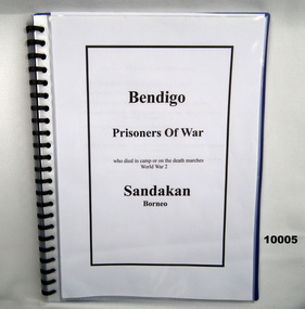
Booklet - BIOGRAPHIES, SANDAKAN, WW2, Doreen Hurst, 'BENDIGO PRISONERS OF WAR"
... Robert BURCHNALL...Francis Alan BURCHNALL...Harold Mervyn GILL...Keith JONES...Charles Henry KING...William...Names listed; Francis Robert BURCHNALL VX64477 Francis Alan BURCHNALL VX58285 Harold Mervyn GILL VX62613 Keith JONES VX30350 Charles Henry KING VX63472 William Patrick SHEPHERD VX66586 Raymond James Russell WHYTE VX64181...Names listed; Francis Robert BURCHNALL VX64477 Francis Alan BURCHNALL VX58285 Harold Mervyn GILL VX62613 Keith JONES VX30350 Charles Henry KING VX63472 William Patrick SHEPHERD VX66586 Raymond James Russell WHYTE VX64181 Francis Robert BURCHNALL Francis Alan BURCHNALL Harold Mervyn GILL Keith JONES Charles Henry KING William Patrick SHEPHERD Raymond James Russell WHYTE Publication Folder Biographies Sandakan Reference Folder with A4 plastic pockets. ...Title Page to folder. "BENDIGO/ PRISONERS OF WAR/ who died in camp or on the death marches, World War 2/ SANDAKAN/ Borneo". Names listed; Francis Robert BURCHNALL VX64477 Francis Alan BURCHNALL VX58285 Harold Mervyn GILL VX62613 Keith JONES VX30350 Charles Henry KING VX63472 William Patrick SHEPHERD VX66586 Raymond James Russell WHYTE VX64181Folder with A4 plastic pockets. Folder cover - front clear plastic. Back - blue plastic. Plastic spiral bound. 18 pages - cut, plain, white colour A4 paper. Black ink print. Illustrations - black and white photographs. francis robert burchnall, francis alan burchnall, harold mervyn gill, keith jones, charles henry king, william patrick shepherd, raymond james russell whyte, publication, folder, biographies, sandakan, reference -
 Bendigo Military Museum
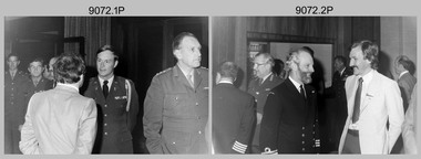
Photograph - Five Nation Mapping, Charting & Geodesy Conference - Army Survey Regiment, Fortuna, Bendigo, 1980
... William L. Nicholson III - D-DMA, Cr Peter Mansell – City of Bendigo councillor, unidentified Royal Canadian Air Force officer, MAJ GEN Eric W Barton CB - UK Director of Military Survey, unidentified, Cr Robert Campbell – City of Bendigo Mayor, D-SVY COL NRJ Hillier, unidentified, COL Stirling (NZ), unidentified NZ Hydrographer, unidentified RAN Hydrographer....William L. Nicholson III - D-DMA, Cr Peter Mansell – City of Bendigo councillor, unidentified Royal Canadian Air Force officer, MAJ GEN Eric W Barton CB - UK Director of Military Survey, unidentified, Cr Robert Campbell – City of Bendigo Mayor, D-SVY COL NRJ Hillier, unidentified, COL Stirling (NZ), unidentified NZ Hydrographer, unidentified RAN Hydrographer. ...This collection of 19 black and white photographs was taken at the Five Nation Mapping, Charting & Geodesy (MC&G) Conference, held at the Army Survey Regiment, Fortuna, Bendigo from the 9th to 11th of September 1980. Directors (or their representatives) from Australia, Canada, New Zealand, United Kingdom and the United States of America military mapping agencies attended Five Nations MC&G Conference. Identifiable attendees were MAJ GEN William L. Nicholson III - D-DMA (USA), MAJ GEN Eric W Barton CB - Director of Military Survey (UK) and COL NRJ Hillier - D-SVY (AUS). It is apparent from the background of the photos that they were taken in the Army Survey Regiment’s Officers/SGTs Mess Dining Room. Directors (or their representatives) from the five nations signed Page 156 of the Army Survey Regiment’s Visitors Book. See Item 6047. This set of 19 black and white photographs was taken during the Five Nation Mapping, Charting & Geodesy (MC&G) Conference, held at the Army Survey Regiment, Fortuna, Bendigo from the 9th to 11th of September 1980. Photos .1P to .18P are on 35mm negative film and scanned at 96 dpi. Photo .19P is printed on photographic paper and scanned at 200 dpi. They are part of the Army Survey Regiment’s Collection. .1) - Photo, black & white, 1980. In background L to R: MAJ John Blackburn, CAPT Paddy Strunks, MAJ David Bowen USA Exchange, in foreground L to R: unidentified, unidentified USA Army Aide de Camp, D-SVY COL NRJ Hillier. .2) - Photo, black & white, 1980. In background L to R: unidentified, unidentified RAN Hydrographer, MAJ GEN Eric W Barton CB - UK Director of Military Survey, MAJGEN William L. Nicholson III – USA D-DMA, unidentified, in foreground L to R: unidentified NZ Hydrographer, Cr Peter Mansell – City of Bendigo councillor. .3) - Photo, black & white, 1980. In background L to R: unidentified, D-SVY COL NRJ Hillier, unidentified NZ Hydrographer, in foreground L to R: unidentified RAN Hydrographer, unidentified. .4) - Photo, black & white, 1980. L to R: MAJ Don Swiney MBE, MAJGEN William L. Nicholson III - D-DMA. .5) - Photo, black & white, 1980. L to R: CAPT Paddy Strunks, MAJ David Bowen USA Exchange, unidentified (x3). .6) - Photo, black & white, 1980. L to R: unidentified (x2), MAJ GEN Eric W Barton CB - UK Director of Military Survey. .7) - Photo, black & white, 1980. L to R: D-SVY COL NRJ Hillier, unidentified. .8) - Photo, black & white, 1980. L to R: MAJ David Bowen USA Exchange, unidentified NZ Hydrographer. .9) - Photo, black & white, 1980. In background L to R: unidentified, CAPT Peter Searle - UK Exchange, in foreground L to R: unidentified, CO LTCOL Bob Skitch. .10) - Photo, black & white, 1980. L to R: CO LTCOL Bob Skitch, unidentified (x2), MAJ GEN Eric W Barton CB - UK Director of Military Survey. .11) - Photo, black & white, 1980. L to R: Cr Peter Mansell – City of Bendigo councillor, CAPT John Harrison. .12) - Photo, black & white, 1980. L to R: CAPT Peter Searle - UK Exchange, unidentified (x2). .13) - Photo, black & white, 1980. L to R: unidentified Royal Canadian Air Force officer, unidentified. .14) & .15) - Photo, black & white, 1980. L to R: unidentified, D-SVY COL NRJ Hillier. .16) - Photo, black & white, 1980. L to R: CAPT Paddy Strunks, unidentified USA Army Aide de Camp. .17) - Photo, black & white, 1980. L to R: CAPT Bob Cooper, MAJ David Bowen USA Exchange, Cr Peter Mansell – City of Bendigo councillor, CAPT John Harrison. .18) - Photo, black & white, 1980. In background L to R: D-SVY COL NRJ Hillier, CAPT Paddy Strunks, in foreground L to R: MAJ John Blackburn, COL Stirling (NZ). .19) - Photo, black & white, 1980. L to R: MAJGEN William L. Nicholson III - D-DMA, Cr Peter Mansell – City of Bendigo councillor, unidentified Royal Canadian Air Force officer, MAJ GEN Eric W Barton CB - UK Director of Military Survey, unidentified, Cr Robert Campbell – City of Bendigo Mayor, D-SVY COL NRJ Hillier, unidentified, COL Stirling (NZ), unidentified NZ Hydrographer, unidentified RAN Hydrographer.No personnel or civilians are identifiedroyal australian survey corps, rasvy, army survey regiment, army svy regt, fortuna -
 Bendigo Military Museum
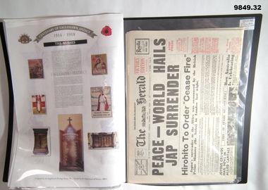
Memorabilia - POSTERS, NEWSPAPER ARTICLES, WW1, Eaglehawk Heritage Society, 1.-30. 2014, - 31. - 32. 1995
... William J. May. 18. McClelland Brothers. 19. Robert R. Metcalf. 20. ...William J. May. 18. McClelland Brothers. 19. Robert R. Metcalf. 20. ...Posters are copies of a framed collection from the Eaglehawk Heritage Society Inc. Refer Cat No. 5155 for first item in that collection.1. to 30 Posters. 31. & 32. Newspapers. 1. to 30. Posters - white colour paper. Printed in colour using memorabilia of WW1 soldiers and their lives. 1. Bellesini Brothers. 2. Bice Brothers. 3. John James Bray. 4. Cairns Brothers. 5. Roy E.G. Calvery. 6. David M. Davies. 7. Arthur E. Dower. 8. George Eddy. 9. Elliott Brothers. 10. Fletcher Family. 11. Harry Fletcher. 12. Flett Brothers. 13. Gee Brothers. 14. Howe Brothers. 15. David J.V. Jamieson. 16. Norman V. Long. 17. William J. May. 18. McClelland Brothers. 19. Robert R. Metcalf. 20. Moyle Family. 21. Francis N. Moyle. 22. Frederick Sheldon. 23. George T. Speedy, Charles E. Speedy. 24. William J. Symons V.C. 25. John E. Wood. 26. Leslie W. Miller. 27. William N. Ruddick, Frederick W.L. Knuckey. 28. John T. Taylor, Alfred A. Priest. 29. Frederick D. Trewarne, Edward J. Siler, 30. The Nurses. 31. & 32. Newspapers - off white paper. Black and colour print. 31. The Herald Victory Edition Souvenir, 50 Years of Freedom 1995. 32. Victory. A Bendigo Advertiser Special Supplement, Tuesday, August 15, 1995. Items stored in "20 pocket A.3 Clear Display Book". Black colour folder cover with clear plastic pockets.memorabilia, posters, newspapers, anzacs -
 Bendigo Military Museum
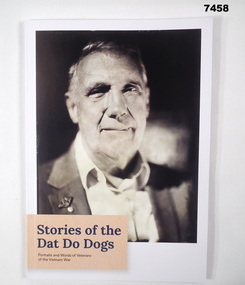
Book - BOOK, VIETNAM, Jock McLAIN in Collaboration with the Anzac Memorial. Commonwealth Department of Veteran Affairs, "Stories of the Dat Do Dogs", 2023
... "Front cover - Ordinary Seaman (Electrical Mechanic) Gary William Oakley". "Back cover - Private Robert Charles Pearson". 60 pages, cut, plain, white paper. ..."Front cover - Ordinary Seaman (Electrical Mechanic) Gary William Oakley". "Back cover - Private Robert Charles Pearson". 60 pages, cut, plain, white paper. ...From cover of book; "Stories of the/ Dat Do Dogs/ Portraits and Words of Veterans/ of the Vietnam War.Soft cover book. Cover - cardboard, with dark blue and black print. Illustrated in black and white, front and back, a portrait of Vietnam War Veterans. "Front cover - Ordinary Seaman (Electrical Mechanic) Gary William Oakley". "Back cover - Private Robert Charles Pearson". 60 pages, cut, plain, white paper. Illustrated black and white and sepia portrait photographs. Map of Vietnam in colour."books, biographies, vietnam -
 Bendigo Military Museum
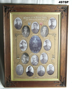
Honour Board - BEEHIVE STORE HONOUR BOARD WW1, Bee Hive Staff, Photographic Honour Roll Members of the Beehive Emporium Staff who served in the Great War WW1, c1918-1925
... Robert Oswald Henderson D.S.O, 38th BN HQ, KIA 29.9.1918. Rank at death Lt Colonel. P, Buddle, Thomas Percy No 3359 9th Reinforcements 58th BN KIA 27.4.1918. 3rd row. C. Wood MM, Charles No 2453 5th Reinforcements 24th BN, MM 20.9.1917, Bar to MM 14.6.1918. T. Henderson MM, Thomas Richard, 15th Reinforcements 5th BN (2nd Lt). Awarded MM after joining the Canadian Army. F. Marriot, Frederick No 1897 13th Reinforcements 4th LH Regt, MM 2.11.1917 4th row. N Meagher, Norman Bernard No 43 38th BN HQ. G.Speedy, George Thomas No 21718 General reinforcements Army medical Corp 1917. W. Trebilcock, William...Robert Oswald Henderson D.S.O, 38th BN HQ, KIA 29.9.1918. Rank at death Lt Colonel. P, Buddle, Thomas Percy No 3359 9th Reinforcements 58th BN KIA 27.4.1918. 3rd row. C. Wood MM, Charles No 2453 5th Reinforcements 24th BN, MM 20.9.1917, Bar to MM 14.6.1918. T. Henderson MM, Thomas Richard, 15th Reinforcements 5th BN (2nd Lt). Awarded MM after joining the Canadian Army. F. Marriot, Frederick No 1897 13th Reinforcements 4th LH Regt, MM 2.11.1917 4th row. N Meagher, Norman Bernard No 43 38th BN HQ. G.Speedy, George Thomas No 21718 General reinforcements Army medical Corp 1917. W. Trebilcock, William ...This honour roll was found in poor condition in a district antique shop. It was fully restored by an enthusiastic local lady, It was presented to the Soldiers Memorial Military Museum on 20 April 2022. The Museum is now known as the Bendigo Military Museum. The Beehive was a major store in Pall Mall Bendigo, the Main Street through the centre of the City. Names on the roll. Top row, E. Buddle, Edgar Peter No 4450 14th reinforcements 6th BN. R Jenkins, Reginald Claude No 4526 14th reinforcements 6th BN. H Crowalladar. Spelt wrong, actually Thomas Henry Cadwallader No 4160 13th Reinforcements 7th BN KIA 18.8.1916. J. A. Williams, John Arnold No 9797 16th reinforcements 2nd Fld Amb. J. Holl, James Thomas No 2432 5th reinforcements 60th BN. 2nd row, N. Veale, (Veal) Norman Joseph No 2070 5th reinforcements 14th BN Major Robert Oswald Henderson D.S.O, 38th BN HQ, KIA 29.9.1918. Rank at death Lt Colonel. P, Buddle, Thomas Percy No 3359 9th Reinforcements 58th BN KIA 27.4.1918. 3rd row. C. Wood MM, Charles No 2453 5th Reinforcements 24th BN, MM 20.9.1917, Bar to MM 14.6.1918. T. Henderson MM, Thomas Richard, 15th Reinforcements 5th BN (2nd Lt). Awarded MM after joining the Canadian Army. F. Marriot, Frederick No 1897 13th Reinforcements 4th LH Regt, MM 2.11.1917 4th row. N Meagher, Norman Bernard No 43 38th BN HQ. G.Speedy, George Thomas No 21718 General reinforcements Army medical Corp 1917. W. Trebilcock, William Edward No 55239 5th General Reinforcements (Vic) 1918. C. P. Fisk, Charles Reginald No 55371 6th General Reinforcements (Vic) 1918. "MM" Military Medal "DSO" Distinguished Service Order The frame is a flat faced hardwood timber, varnished. Each corner has a decorative scroll work of leaves and flowers. They are dark brown colour. There is a gold rim around the inside of the picture frame. Inside are 15 oval openings, in which are black and white portraits of WW1 soldiers. The writing and captions are in white paint. Each name has a decorative loop around it. There are two sets of National flags painted near the top. Red and blue tints.ww1, honour roll, beehive -
 Bendigo Military Museum
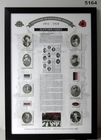
Memorabilia - CENTENARY of EAGLEHAWK ANZACS, FRAMED, Eaglehawk Heritage Society, FLETCHER FAMILY, c2014
... PRIVATE JEFFREY WILLIAM FLETCHER, No , 13th Light Horse Regiment, RTA RICHARD FLETCHER - Employed as a Munitions Worker in England. PRIVATE JOHN FLETCHER, No 2723, 38th Battalion, RTA PRIVATE SEPTIMUS FLETCHER, No 4485, 7th Infantry Battalion, RTA. PRIVATE ROBERT...PRIVATE JEFFREY WILLIAM FLETCHER, No , 13th Light Horse Regiment, RTA RICHARD FLETCHER - Employed as a Munitions Worker in England. PRIVATE JOHN FLETCHER, No 2723, 38th Battalion, RTA PRIVATE SEPTIMUS FLETCHER, No 4485, 7th Infantry Battalion, RTA. PRIVATE ROBERT ...PRIVATE JOSEPH FLETCHER, No 1226, 16th Infantry Battalion, RTA. PRIVATE JEFFREY WILLIAM FLETCHER, No , 13th Light Horse Regiment, RTA RICHARD FLETCHER - Employed as a Munitions Worker in England. PRIVATE JOHN FLETCHER, No 2723, 38th Battalion, RTA PRIVATE SEPTIMUS FLETCHER, No 4485, 7th Infantry Battalion, RTA. PRIVATE ROBERT MARTIN, No 662, 7th Infantry Battalion, died accidental injury in Egypt 26 Feb 1915. Memorabilia - Framed story of a family, in colour, using memorabilia of the soldiers and their lives. Printed on paper. Frame - black extruded plastic, glass front, cardboard backing.FLETCHER FAMILY framed item, anzacs, eaglehawk -
 Emerald Museum & Nobelius Heritage Park
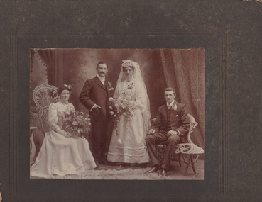
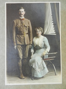
Photograph, E. Strawbridge, Nightingale/Thompson Collection, April 1909
... Bridesmaid - Sophie THOMPSON (sister to William) Groomsman - Robert Charles VALE THOMPSON NIGHTINGALE TELFER VALE Makers Mark: E Strawbridge, 129 Park Street, Parkville. ...Wedding photograph of William John Seymour THOMPSON to Agnes Helen TELFERFrom collection of Emma NIGHTINGALE. Agnes's father Joseph was an orchardist in Vermont. These THOMPSONS not related to Emma Nightingale. Bridesmaid - Sophie THOMPSON (sister to William) Groomsman - Robert Charles VALEB/W Photograph on dark brown card of wedding partyMakers Mark: E Strawbridge, 129 Park Street, Parkville. Inscription on back: To Mrs Nightingale with compliments from Mr. & Mrs. W. Thompson April 1909thompson, nightingale, telfer, vale -
 Bendigo Military Museum
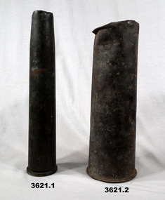
Weapon - SHELL CASES, c.1914 - 1945; .3) 3.1916; .4) 1940
... Brain, Henry Baker VX47758, Patterson, Clive Douglas VX17382, Gaston, Stanley William VX18709, Dawson, VX36870, Tonkin, Archibald William VX20511, Kilburn, Douglas Barry VX18171, Long, Michael Roderick VX26974, Boyle, Allan Lemnos VX48814, Schmidt, Bruno Alexander VX43575, Bennett, Walter George VX44891, Hardstaff, John Robert NX5930. ...Brain, Henry Baker VX47758, Patterson, Clive Douglas VX17382, Gaston, Stanley William VX18709, Dawson, VX36870, Tonkin, Archibald William VX20511, Kilburn, Douglas Barry VX18171, Long, Michael Roderick VX26974, Boyle, Allan Lemnos VX48814, Schmidt, Bruno Alexander VX43575, Bennett, Walter George VX44891, Hardstaff, John Robert NX5930. ...Names re 59th Light Aid Detachment. Brain, Henry Baker VX47758, Patterson, Clive Douglas VX17382, Gaston, Stanley William VX18709, Dawson, VX36870, Tonkin, Archibald William VX20511, Kilburn, Douglas Barry VX18171, Long, Michael Roderick VX26974, Boyle, Allan Lemnos VX48814, Schmidt, Bruno Alexander VX43575, Bennett, Walter George VX44891, Hardstaff, John Robert NX5930. Milgate is the only name not readily identifiable. Hardstaff enlisted in 1939, all the rest enlisted in 1940..1) Dark metal slim line shell casing. .2) Dark metal shell casing. Dented at top. .3) Brass shell casing. .4) Brass shell casing..4) Etched on outside of shell: “59LAD 21 INF BDE HQ” “CAPT H B BRAIN, WOII C D PATTERSON, CPL S W GASTON, CPL A C DAWSON, PRIVATES: A W TONKIN, D B KILBURN, M R LONG, A L BOYLE, S H MILGATE, B SCHMIDT, W G BENNETT, J R HARDSTAFF”weapon, shell cases -
 Bendigo Military Museum
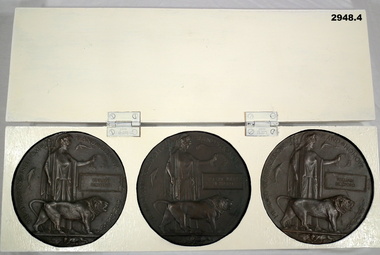
Memorabilia - MEMORIAL PLAQUES, Bickford Family, Plaques post WW1
... Robert John Bickford No 1518 enlisted in the AIF in the 1st reinforcements 21st Batt on 8.4.1915 age 30 years 11 months. Embark for Egypt 8.4.1915, embark for Gallipoli 29.8.1915, hospital with Mumpa 20.1.1916, rejoin unit 7.3.1916, embark for France 19.3.1916, awarded the Military Medal (MM) as a Lewis Gunner and Gallantry under fire since March 1916, promoted CPL 1.9.1916, hospital with Odema of the feet 8.11.1916, rejoin unit 22.11.1916, WIA 12.1.1917 SW’s to Groin and Abdomen, DOW;s Flers 12.1.1917. William...In the rectangular box, embossed is the name Edward Bickford. .2) As above description though in the rectangular box is the name Robert John Bickford. .3) Descriptions as above though in the rectangular box is the name William Bickford. .4) Heavy wooden display case painted cream colour, 2 hinges on the side, no lock or catch. ...In the rectangular box, embossed is the name Edward Bickford. .2) As above description though in the rectangular box is the name Robert John Bickford. .3) Descriptions as above though in the rectangular box is the name William Bickford. .4) Heavy wooden display case painted cream colour, 2 hinges on the side, no lock or catch. ...Edward Bickford No 1519 enlisted in the AIF in the 1st reinforcements 21st Batt on 8.4.1915 age 25 years. Embarked for for Egypt 28.6.1915, embark for Gallipoli 29.8.1915, embark for France 19.3.1916, reported MIA 26.8.1916, a Court of inquiry dated 20.7.1917 found that he was KIA 26.8.1916 at Moquet Farm. Robert John Bickford No 1518 enlisted in the AIF in the 1st reinforcements 21st Batt on 8.4.1915 age 30 years 11 months. Embark for Egypt 8.4.1915, embark for Gallipoli 29.8.1915, hospital with Mumpa 20.1.1916, rejoin unit 7.3.1916, embark for France 19.3.1916, awarded the Military Medal (MM) as a Lewis Gunner and Gallantry under fire since March 1916, promoted CPL 1.9.1916, hospital with Odema of the feet 8.11.1916, rejoin unit 22.11.1916, WIA 12.1.1917 SW’s to Groin and Abdomen, DOW;s Flers 12.1.1917. William Bickmore No 815 enlisted in G Coy 14th Batt on 12.9.1914 age 21 years 11 months. Embark for Egypt 22.12.1914, embarked for Gallipoli, WIA 4.6.1915 shrapnel wound left arm, returned to Australia for discharge stating Stiffness of the Arm15.8.1915, return to Egypt in the 14th reinforcements and rejoin the 14th Batt 2.4.1916, embark for France 1.6.1916, promoted L/Cpl 1.9.1916, promoted Cpl 24.3.1917, reported MIA 11.4.1917, Court of Inquiry found he was KIA 11.4.1917 at Bullecourt. Refer 2949P, 2950P, 2991P for their photos.Bickford Family Set of WWI Commemorative Plaques: .1) Bronze Death Plaque, British pattern showing a helmeted female (Brittanica) in classic style dress holding a trident in right hand, wreath in the other & a lion at her side. In the rectangular box, embossed is the name Edward Bickford. .2) As above description though in the rectangular box is the name Robert John Bickford. .3) Descriptions as above though in the rectangular box is the name William Bickford. .4) Heavy wooden display case painted cream colour, 2 hinges on the side, no lock or catch. Inside are 3 recessed circular holes to hold the plaques.Written on rear of box is: “A.T.B. 94”military history, memorial, plaques -
 Bendigo Military Museum
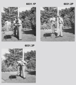
Photograph - Farewell to Retiring Army Survey Regiment RSM and RSM Handover, 1st of March 1982
... These proof photographs were printed on photographic paper and are part of the Army Survey Regiment’s Collection. 310963 WO1 Aubrey William Harvey served from Feb 1952 till Mar 1982, he was RSM Army Survey Regiment from 1976 -82. 54080 LTCOL Peter Eddy served from 1960-1983 and was CO Army Survey Regiment 1981-82. WO1 Robert...These proof photographs were printed on photographic paper and are part of the Army Survey Regiment’s Collection. 310963 WO1 Aubrey William Harvey served from Feb 1952 till Mar 1982, he was RSM Army Survey Regiment from 1976 -82. 54080 LTCOL Peter Eddy served from 1960-1983 and was CO Army Survey Regiment 1981-82. WO1 Robert ...These 11 x black and white photographs were taken at a farewell to the retiring RSM WO1 Aubrey Harvey on the 1st of March 1982 at the Fortuna Villa flag pole Army Survey Regiment, Bendigo. The RSM handover also occurred that day. These proof photographs were printed on photographic paper and are part of the Army Survey Regiment’s Collection. 310963 WO1 Aubrey William Harvey served from Feb 1952 till Mar 1982, he was RSM Army Survey Regiment from 1976 -82. 54080 LTCOL Peter Eddy served from 1960-1983 and was CO Army Survey Regiment 1981-82. WO1 Robert (Bob) Mason succeeded WO1 Aub Harvey as RSM and served as RSM 1982-1986.These 11 black and white photographs were taken at a farewell to the retiring RSM WO1 Aubrey Harvey and the RSM Handover in 1982 at the Fortuna Villa flag pole, Army Survey Regiment, Bendigo. These proof photographs were printed on photographic paper and are part of the Army Survey Regiment’s Collection. The photographs were scanned at 600 dpi. 400 dpi. .1) - Photo, black & white, 1982. L - R Unknown, LTCOL Peter Eddy (CO Army Survey Regiment) WO1 Aub Harvey, WO1 Bob Mason (incoming RSM) .2) to .7) - Photo, black & white, 1982. L - R LTCOL Peter Eddy (CO Army Survey Regiment) WO1 Aub Harvey .8) to .11)- Photo, black & white, 1982. L - R WO1 Bob Mason WO1 Aub HarveyOn Rear, " WO1 Harvey's farewell" . Date '01/03/1982' provided with photos in Photo Folder 26.royal australian survey corps, rasvy, fortuna, army survey regiment, army svy regt, asr -
 RSL Victoria - Anzac House Reference Library and Memorabilia Collection
Photographs and Letters of Frederick George & Mary Jane BOXALL
... william henry johnson...8th battalion...linton percy clarence rudd...allan tathorn moffat...robert...He returned to Australia on 8 May 1916, having suffered "shell shock" from a bomb blast on Gallipoli in September 1915. ww1 george frederick boxall mary jane boxall mary jane johnson william henry johnson 8th battalion linton percy clarence rudd allan tathorn moffat robert carter photographs letters great extended hustlers mine shell shock Hustlers Mine photograph inscribed on rear : "at the mouth of the shaft after the accident at Great Extended Hustlers" Photographs and Letters of Frederick George & Mary Jane BOXALL ...George Frederick Boxall (1051 8th Battalion H Company), a miner from Bendigo, embarked from Melbourne on board Transport A24 Benalla on 19 October 1914. He returned to Australia on 8 May 1916, having suffered "shell shock" from a bomb blast on Gallipoli in September 1915.Hustlers Mine photograph inscribed on rear : "at the mouth of the shaft after the accident at Great Extended Hustlers"ww1, george frederick boxall, mary jane boxall, mary jane johnson, william henry johnson, 8th battalion, linton percy clarence rudd, allan tathorn moffat, robert carter, photographs, letters, great extended hustlers mine, shell shock -
 Bendigo Military Museum
Book - BIOGRAPHY, MOUNTBATTEN, George Rainbird Pty Ltd, "MOUNTBATTEN - EIGHTY YEARS IN PICTURES", 1979
... Books Biography Mountbatten William John Sullivan Handwritten inscription - blue ink pen. "JAMES A & N.B./ FOR RESERACH FOR CHERYL/ BUT ALSO FOR/ STEVEN & ROBERT PARK" "To Gary Rae/ From/ Nan Hallion/ 1991" Hard cover book with dust cover. ...Item is in the collection of "William John SULLIVAN" VX57829. Refer Cat. No. 9523P for his service details.Hard cover book with dust cover. Hard cover - cardboard with adhered blue buckram with gold print on spine. Dust cover - paper, gloss finish. Black, white and gold print on front, spine and back. Illustrated front and back colour photograph full length portrait of Mountbatten. 224 pages - cut, plain, white paper Pictorial book, with black and white and colour photographs. End papers - front and back - illustrated with a family tree. Handwritten inscription on first page.Handwritten inscription - blue ink pen. "JAMES A & N.B./ FOR RESERACH FOR CHERYL/ BUT ALSO FOR/ STEVEN & ROBERT PARK" "To Gary Rae/ From/ Nan Hallion/ 1991"books, biography, mountbatten, william john sullivan -
 Bendigo Military Museum
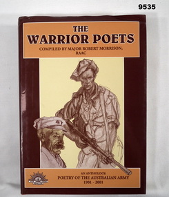
Book - ANTHOLOGY, ARMY, 1901 - 2001, Major Robert MORRISON RAAC, "THE WARRIOR POETS", 2001
... William John Sullivan Hard cover book with a dust cover. Hard cover - cardboard, with adhered orange colour buckram, gold colour print on spine. Dust cover - paper, gloss finish. Brown, pale yellow and white print on front, spine and back. Front illustration - sepia tones drawings of two men, poet and soldier, with Bren Gun. Back illustration sepia tone drawing of AWAS Typist. 435 pages - cut, plain white paper. Illustrated black and white, sepia and colour photographs, paintings, sketches and line drawings. End papers - back - CD in clear plastic pouch adhesive taped to page. "THE WARRIOR POETS" Book ANTHOLOGY, ARMY, 1901 - 2001 Major Robert ...Item in collection of "William John SULLIVAN", VX57829. Refer Cat. No. 9523P for his service details. From book cover; THE WARRIOR POETS, AN ANTHOLOGY: POETRY OF THE AUSTRALIAN ARMY 1901-2001.Hard cover book with a dust cover. Hard cover - cardboard, with adhered orange colour buckram, gold colour print on spine. Dust cover - paper, gloss finish. Brown, pale yellow and white print on front, spine and back. Front illustration - sepia tones drawings of two men, poet and soldier, with Bren Gun. Back illustration sepia tone drawing of AWAS Typist. 435 pages - cut, plain white paper. Illustrated black and white, sepia and colour photographs, paintings, sketches and line drawings. End papers - back - CD in clear plastic pouch adhesive taped to page.books, army, anthology, william john sullivan