Showing 13708 items
matching wye-river-bridge
-
 Marysville & District Historical Society
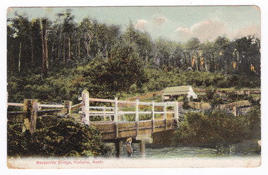
Postcard (Item) - Colour tinted postcard, Nicholas John Caire, Marysville Bridge, Victoria, Austr, 1878-1904
One of a series of postcards of photographs taken by socialite photographer Nicholas John Caire.One of a series of postcards of photographs taken by socialite photographer Nicholas John Caire. N.J. Caire had a great love for the area in and surrounding Marysville and in the late 1800's took many photographs of Marysville and its surrounds. N.J. Caire was born in 1837 in Guernsey. He arrived in Adelaide about 1860 along with his parents who encouraged his early interest in photography. He opened a studio in Adelaide in 1867 after traveling extensively throughout the Gippsland taking photographs. After marrying in 1870 he moved to Talbot in Victoria until 1876 when he opened a studio in the Royal Arcade in Melbourne. After 1885 N.J. Caire gave up his city work and made his home in South Yarra and devoted the rest of his life to outdoor photography, specializing in the bush, the gullies and the mountains of south-eastern Victoria.POST CARD This Space may be Used/ for Correspondence The Address Only to be/ Written Here. 88421 Dear Miss McNair./ We arrived home/ quite safely on Sat./ The children met/ us with Fran and/ Auntie Ethel at the/ Circular Quay. All/ were well and real/ glad to have us home/ again. We were so sorry/ we were too late/ for the train. We thought/ we saw Mr Mr McNair walking from/ the train. Love to ????/ Kisses for Ollie from A.M.G. Miss McNair/ Wattle Street/ Bendigo/ Victoriamarysville, victoria, nicholas john caire, bridge scene, 88421, postcard, souvenir -
 Eltham District Historical Society Inc
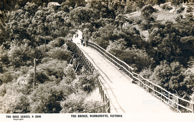
Photograph, The Bridge, Warrandyte, Victoria
Postcard showing old timber bridge over Yarra River at WarrandyteThe Rose Series P.2046bridges, yarra river, warrandyte, kangaroo ground road, postcards -
 Federation University Historical Collection
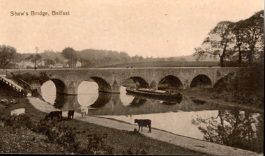
Postcard - Sepia, Valentine, Shaw's Bridge, Belfast
A bridge with five arches crossed a river in Belfast. Cows graze in the foreground -
 Kiewa Valley Historical Society
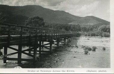
Photograph - Bridge at Tawonga 1936, 22/03/1936
First Tawonga bridge was built in 1884- destroyed by floods in 1916. New bridge constructed 1923 and destroyed in 1953. Present concrete bridge constructed in 1986 and named Ryders BridgeBridge construction over Kiewa River at TawongaBlack and white photographic postcard of the bridge at Tawonga across the Kiewa River.Handwritten in pencil on rear of photograph - Sunday 22nd March, 1936. Printed on front - Bridge at Tawonga across the Kiewa (Blumer, photo)tawonga bridge, kiewa valley -
 Stawell Historical Society Inc
Photograph, Bridge Building -- Possibly Delley's Bridge c1901
Photo of 3 women with a dog standing on a bridge with 5 men possible working on the Bridge in the Grampians. Photo taken in the area where Delley’s Bridge now stands, Hall’s Gap. c1901Sepia Post Card depiction people around a log bridge over a waterway in bush setting.Post Cardstawell -
 Orbost & District Historical Society
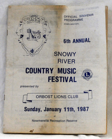
souvenir program, 1987
The annual Snowy River Country Music Festival was organised by the Lions Club of Orbost and held at the Newmerella Recreation Reserve. The 6th event was held on Sunday, Jan 11 1987.This program is significant in that it is a souvenir of a local event which no longer takes place.An official souvenir program for the 6th annual Snowy River Country Music Festival, 1987. B/W print.snowy-river-country-music-festival program souvenir -
 Orbost & District Historical Society
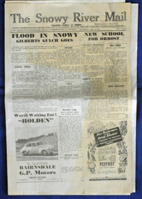
newspaper, 15.2.1950
The Snowy River Mail is a weekly newspaper published in Orbost in the Shire of East Gippsland, Victoria, Australia. Previously published as The Snowy River mail and Tambo and Croajingolong gazette from 1890 to 1911. The Gippsland Courier merged with the Snowy River Mail when proprietor Lachlan Ross moved to Orbost in 1910. In 1999 the paper was acquired by the Yeates family when the Hollins family retired from the newspapers business. The paper is still being produced by the fourth generation of the Yeates family as part of East Gippsland Newspapers. The flood in 1950 was a significant Orbost event. This newspaper is a contemporary record of a significant local events.A Snowy River Mail newspaper dated 15,.2.1950. It contains news articles and advertisements in black/white print. There is an artcle about the Orbost floods.newspaper snowy-river-mail flood-1950-orbost -
 Kew Historical Society Inc
Photograph, Marnie McLeod, Floods of the River Yarra at Kew, 1916
The donation was accompanied by the following letter from the donor: "Hi. I found these in with family photos. Taken by family as Mamie McLeod was living in Fellows Street, Kew, so would be near there. Retain (or discard) as you see fit." [Donor's name and address withheld from public view]. To gain an insight into the flood levels at Kew, it is worth reading newspaper accounts of the event. The Age published an article - Valuable Gardens Destroyed at Kew - on 25 September 1916: "VALUABLE GARDENS DESTROYED AT KEW. From the heights of Studley Park, Kew, a splendid view of the flood waters can be obtained, and yesterday afternoon, despite continuous rain, crowds of citizens assembled there to witness the spectacle. There is a vast stretch of water some 300 or 400 yards broad, above the foot bridge connecting Gipps-street, Collingwood, and Studley Park. The river is only about 3 feet from the top of the embankment connecting with the ramp of the bridge on the Studiey Park side. When the upper llood waters come down it is almost a certainty that tne embankment will be submerged and the bridge rendered impassible. Below the bridge the waters again stretch out, and have submerged all the low-lying land on the Collingwood side and invaded the back premises ot the Kodak Co., Phoenix Biscuit Factory, a tannery adjoining thereto, the Shamrock Brewery, and Chinese gardens in the vicinity. At Walmer-street-bridge, at the end of Studley Park, the low-lying land on the Kew side is covered with water to the depth of many feet. Tlie land in question is owned in a great part by Mr Frank Lavers who haa gone in for intense culture on a pretty liberal scale on both the slopes of the hill and on the river flat. On the latter he is cultivating many acres of asparagus, and has at a considerable cost spent three years in preparing the ground and installing an irrigation system, reticulated from the Yan Yean water supply. This year the asparagus was put down, and the plants were in a promising condition. Tlie flood waters are now flowing fast over the land. The crop is ruined, and three years' work and expenditure destroyed. Mr. Laver's private residence fortunately is high above flood level, but two houses he owns off Young-street have been flooded out. Having been warned in time, the tenants removed their furniture hefore the water came down to Mr. Laver's residence, where they themselves have been given accommodation in the meantime. All the river flats in East Kew are under water. One or two low-lying houses have been flooded. Chipperfield's boat shed at Willsmere is nearly covered, and some Chinese gardens in the vicinity are several feet under water."This, and the other three photographs donated of floods in Kew are believed to be the earliest in the collection. Together with our original MMBW River Yarra map showing flood levels, these items, when compared allow researchers to gain a visual perspective of the extent of the flood in 1916. Black and white photograph of flooded trees in Kew with rising dry ground in distance.Inscription on reverse in pencil: "Flood River Yarra Kew Vic"river yarra, kew, floods 1916 -
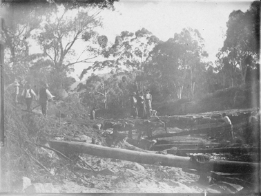
 Orbost & District Historical Society
black and white photograph, first half 20th century
This is the Dalgety bridge across the Snowy River. It is a steel construction.The first bridge over the river was constructed in 1888. There was a punt across the river before the bridge was built . Dalgety is a small service centre, located on the Snowy River approximately 235 km from Orbost. It was an early consideration for the site of Australia,s capital city. The Dalgety Bridge over the Snowy River has been an important item of infrastructure in the history of New South Wales for over 110 years. It was designed by noted bridge engineer J. A. McDonald,and was a technically sophisticated bridge structure for its time. This is a pictorial record of a significant structure on the Snowy River.A small black / white photograph of a large bridge over a river.bridge-dalgety-snowy-river -
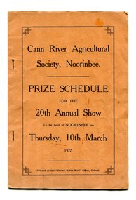 Orbost & District Historical Society
program, Snowy River Mail, 1927
Cann River is a town in the East Gippsland region of Victoria in Australia. The town is located on the Cann River at the junction of the Princess Highway and the Monaro Highway, in the Shire of East Gippsland. Before 1929 the original Cann River settlement was where Noorinbee now stands.Agricultural shows are an important part of cultural life in small country towns and these shows form an integral part of local history. This item reflects the significance of a volunteer group which no longer exists.A stapled paper program, orange with black print,"Cann River Agricultural Society, Noorinbee Prize Schedule for the 20th Annual Show to be held at Noorinbee on Thursday 10th March 1927" inside a rectangular black frame. -
 Phillip Island and District Historical Society Inc.
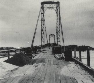
Photograph, Suspension Bridge, 1939 - 40
Suspension Bridge completed in 1940 and opened by Hon. Albert Dunstan MLA, Premier of Victoria. First Phillip Island Bridge under constructionPhillip Island Suspension Bridge taken along length of bridge - under constructionlocal history, photographs, bridges, phillip island - suspension bridge, black & white photograph, jack jenner, phillip island bridges -
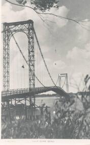
 Phillip Island and District Historical Society Inc.
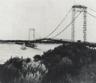
Photograph, Suspension Bridge, 1940's
Phillip Island Suspension Bridge, showing workmen bridge. Bridge completed 1940 and opened by Hon. Albert Dunstan MLA, Premier of Victoria.Phillip Island Suspension Bridge taken from San Remo shoreline with sailing boat underneath and workmen on bridgelocal history, photographs, civil engineering, bridges, phillip island suspension bridge, black & white photograph, jack jenner collection, phillip island bridges, public construction -
 Linton and District Historical Society Inc
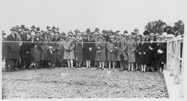
Photograph, Opening of Bridge over Woady Yaloak Creek, between Linton and Scarsdale, 1928, 1928
Black and white photograph of a crowd of men, women and children standing behind a ribbon stretched between sets of bridge rails."Opening of bridge between Linton and Scarsdale".events, bridge openings, woady yaloak creek, faull collection -
 Eltham District Historical Society Inc
Photograph, Russell Yeoman, Warrandyte Bridge, c.1970, 1970c
Black and white photograph of Warrandyte Bridge over Yarra River c.1970warrandyte, yarra river, bridges -
 Eltham District Historical Society Inc
Photograph, Old Warrandyte Bridge
Postcard showing old timber trestle Warrandyte Bridge over Yarra Riverbridges, yarra river, warrandyte, kangaroo ground road -
 Nillumbik Shire Council
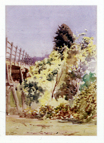
Painting: Walter WITHERS (b.1854 Warwickshire, UK — d.1914 Eltham, Aus), Trestle Bridge, Eltham, c.1903-10
Walter Withers was a significant Australian landscape artist and a member of the Heidelberg School of Australian Impressionists. In 1903 Withers bought 'Southernwood', a house on 2½ acres (1 ha) at Eltham, to which he added a studio. Because of ill health, he lived during the week at his studio in Oxford Chambers, Melbourne, and on weekends and holidays with his family at Eltham until his death in 1914. The Eltham rail bridge is a unique and valuable historic relic of an earlier steam locomotive transport era in the Diamond Creek Valley and has long formed an important part of a magnificent Eltham landscape. When built in 1902 it was close to the terminus point of the Heidelberg-Eltham rail extension, on the route of the proposed Diamond Valley Railway that was then planned to continue much further up the valley towards Kinglake. This bridge is situated in attractive river-valley parkland amidst the tall and spreading manna gums and candlebarks of the Diamond Creek Valley. The Alistair Knox Park river-valley landscape, of which the timber trestle bridge is an important visual component, has been classified by the National Trust. Large manna gum and candlebark trees adorn the adjacent creek banks, and historic Shillinglaw Cottage is also part of this much-prized Eltham landscape. Eltham is home to a historic wooden railway trestle bridge. Mainly of timber-pier and timber-beam construction, but varied by a few longer steel-joists spans on timber piers at the main stream channel, this substantial bridge has almost two hundred metres of timber deck. Built in 1902, it is the only railway bridge of predominantly timber construction that is still in regular use as an integral part of Melbourne's metropolitan electric railway network and one of extremely few timber rail bridges in the State that still carry trains. Apart from its important continuing social function as a carrier of rail transport for the Hurstbridge line, this impressive bridge and its beautiful parkland environs contribute much to the character of Eltham township and that town's special reputation as an historic centre of environmental and conservation concerns. This section of the Diamond Creek Valley was the subject of a Walter Withers painting in the earliest years of the twentieth century and has strong historic links with our Heidelberg School of painters. Watercolour painting on paper of Eltham's Trestle Bridge in the middle of the day. A small section of the wooden bridge is located to the left of the painting. The focus is predominately on the wattle, manna gum and candlebark trees that is to the right of the bridge. The golden hues typically represent the australian sunlight and landscape. "W.W" in gothic script on the lower right side of the painting. Not dated. withers, eltham, trestle bridge, railway, watercolour -
 Tatura Irrigation & Wartime Camps Museum
Photograph, Goulburn River, 1880
Taken by photographer for State Rivers and Water Supply CommissionMedium sized black and white photograph. Red gum and man on river bank in foreground - fast flowing river - opposite bank shown upper corner.victoria state rivers and water supply commission, goulburn river -
Greensborough Historical Society
Maps, Plenty River, 1837o
These maps show the land use along the Plenty River. Both Aboriginal and white settlements are shown.Set of maps showing the Plenty River. -
 Port Fairy Historical Society Museum and Archives
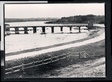
Photograph - Photograph,copy
Port Fairy Moyne river bridgeBlack and white photograph of Moyne river traffic bridgebridge, moyne river, low tide, griffith street -
 Lakes Entrance Historical Society
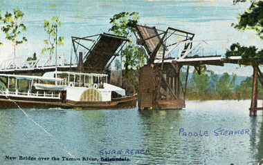
Photograph - Bridges, V S M Series, 1920 c
Hand tinted postcard showing Paddle Steamer 'Tanjil' passing upstream under the open Swan Reach Bridge on the Tambo River, East Gippsland, Victoria.New Bridge over the Tambo River Swan Reach Paddle Steamerships and shipping, waterways, bridges -
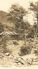 Lakes Entrance Historical Society
Photograph - Post card Rose series 3643 Warburton, Rose Stereographers Armadale Victoria, Yarra River, Warburton Victoria, 1920 - 30 c
The writer of the message on back of card was a Miss Ruth Catt who boarded with the family of Vic and Myrtle Fish of Roadknight St Lakes Entrance in the 1920 - 30 She was a teacher at the Bunga Creek State School East of Lakes Entrance and walked through the bush to schoolSepia toned postcard showing white wooden bridge over Yarra River with hill at back densely wooded shrubbery along river bank and rocky foreground at Warburton VictoriaThe Rose Series P3643 The Beautiful Yarra Warburton Victoriaschool teachers, correspondence -
 Phillip Island and District Historical Society Inc.
Photograph, Suspension Bridge, 1940's
Donated by John JanssonBlack & White photograph of the San Remo to Newhaven Bridge taken from San Remo in foreground to Newhaven in background."Photo Shop Series" "Phillip Island Bridge"phillip island bridge, john jansson -
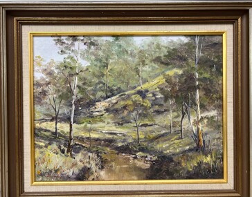 Greensborough Historical Society
Painting - Painting (Framed), Plenty River South Morang by Doug Hall, 1970s
Bush scene of the Plenty River at South Morang showing young gum trees on the river bank, painted by Greensborough artist, the late Doug Hall.This painting has strong ties to the Greensborough area, being owned by Ivy Lines who gifted it to the donor's mother-in-law.Oil painting of a bush scene, in timber frame.On back of painting "Plenty River South Morang. Doug Hall"doug hall, plenty river, south morang, painters -
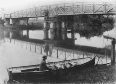 Lakes Entrance Historical Society
Photograph, Caire, Nicholas John, Swing Bridge Sale Victoria c1905, 1905c
Latrobe Bridge Sale Victoria in closed position . The operating machinery is still visibleBlack and white photograph of the Latrobe Bridge, in its closed position. The operating machinery is visible, plus the unique pier structure of the central span. In the rowing boat moored along side the river bank, a person wearing a boater hat is seated. Sale Victoriawaterways, bridges, civil engineering -
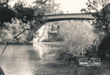
 Ringwood and District Historical Society
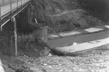
Photograph, Mullum Mullum Creek new bridge work commences. Warrandyte Road, Ringwood - 1986
Start of new bridge, Warrandyte Rd. Ringwood 1986 (2 views)Written on back of photograph, "Start of new bridge, Warrandyte Rd. 1986." -
 Melbourne Tram Museum
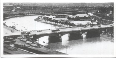
Photograph - Yarra River and Princes Bridge from Flinders St Station clock tower, Town and Country Journal, 1909
Photos show the Yarra river looking east over Princes Bridge. In both photos are cable trams, the rowing sheds and parts of Flinders St station. The first phtograph shows the nearly completed ramps from the platform, while the second has the former exit structure that allowed passengers to exit to Princes Bridge and St Kilda Road. Yields information about Yarra River, Flinders St railway station yards and Princes Bridge.Set of two photographs looking east from a Flinders St Station clocktower. over the Yarra River and Princes Bridge..1 – Melbourne Princes Bridge. Copy neg Mark Plummer collections ex late John Alfred collection. Has “T&C 20/12/09” in pencil on rear. .2 – Melbourne – Princes Bridge “Town and Country Journal 29/12/1909” Copy neg Mark Plummer collections ex late John Alfred collection.bridges, flinders st station, yarra river, railways, princes bridge, cable trams -
 Greensborough Historical Society
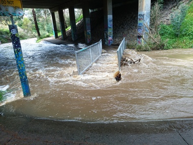
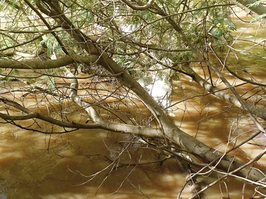
Photograph - Photograph - Digital Image, Marilyn Smith, Plenty River high water 2020, 24/08/2020
Digital images of high water in the Plenty River at Greensborough 24/08/2020. Part of a collection of miscellaneous historical images with a connection to the local area.7 Digital colour photographs of the Plenty River. plenty river, floods -
 Greensborough Historical Society
Photograph - Photograph - Digital Image, Marilyn Smith, Plenty River high water 2020, 24/08/2020
Digital images high water in the Plenty River at Greensborough 24/08/2020. Part of a collection of miscellaneous historical images with a connection to the local area.7 Digital colour photographs of the Plenty River. plenty river, floods -
![View on the Upper Buckland River / [by] Nicholas Caire, circa 1876](/media/collectors/550653872162f11fb04854aa/items/57830fc0d0cdd1176c450fda/item-media/57831013d0cdd1176c454bda/item-fit-380x285.jpg) Kew Historical Society Inc
Kew Historical Society IncPhotograph, Anglo-Australasian Photographic Company, View on the Upper Buckland River, c. 1876
Nicholas Caire was born on Guernsey in the Channel Islands in 1837. He arrived in Adelaide with his parents in about 1860. In 1867, following photographic journeys in Gippsland, he opened a studio in Adelaide. From 1870 to 1876 he lived and worked in Talbot in Central Victoria. In 1876 he purchased T. F. Chuck's studios in the Royal Arcade Melbourne. In 1885, following the introduction of dry plate photography, he began a series of landscape series, which were commercially successful. As a photographer, he travelled extensively through Victoria, photographing places few of his contemporaries had previously seen. He died in 1918. Reference: Jack Cato, 'Caire, Nicholas John (1837–1918)', Australian Dictionary of Biography.An original, rare photograph from the series 'Views of Victoria: General Series' by the photographer, Nicholas Caire (1837-1918). The series of 60 photographs that comprise the series was issued c. 1876 and reinforced a neo-Romantic view of the Australian landscape to which a growing nationalist movement would respond. Nicholas Caire was active as a photographer in Australia from 1858 until his death in 1918. His vision of the Australian bush and pioneer life had a counterpart in the works of Henry Lawson and other nationalist poets, authors and painters.‘View on the upper Buckland River’ : Views of Victoria (General Series) No.46 : Albumen silver photograph | Photo on card with Title and Description on reverse | Mounted 24 x 30 cm; Photo 12 x 17 cm.On Reverse: ‘The Buckland River is situated near the western extremity of the Australian Alps, and forms one of the sources of the Ovens River. Its watercourse is very shallow, except in flood time. Our illustration is taken on the upper portion of the River, near Reeve’s dam.’nicholas caire (1837-1918), buckland river (vic), landscape photography - victoria -
 Lakes Entrance Historical Society
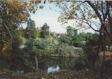
Photograph - Mitchell River Bairnsdale Victoria, 1991 c
taken from across the river looking back towards picnic area on right, site of old swimming pool below Court House. Colour photograph of Mitchell River Bairnsdale Victoria. Also three colour photographs of Mitchell River at Bairnsdale taken autumn 1991 settlement, rivers, topography