Showing 24370 items
matching matthew-creek
-
 Bendigo Historical Society Inc.
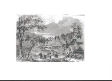
Photograph - RAILWAYS COLLECTION: PHOTO OF A SKETCH OF 'JACKSON CREEK VIADUCT OPENING
Railways collection -photo of a sketch of 'Jackson Creek Viaduct Opening (Courtesy ARHS Vic Division Inc.)'. The Jackson Creek Viaduct is a bridge about 24 miles from Melbourne and is 80 feet high being constructed of Footscray Bluestone piers and abutments and wrought iron girders. The girders were made in England and delivered to the colony by the time the the piers were ready to receive them. The laying of the foundation stone of this viaduct marked the opening of the line to Sunbury on 13 January 1859.photo, 'jackson creek viaduct -
 Bendigo Historical Society Inc.
Map - TARNAGULLA : COUNTY OF BENDIGO, 1959
Map. Tarnagulla, County of Bendigo, County of Gladstone, Inglewood, Glenalbyn, Kingower, Moliagul, Painswick, Waanyarra, Laanecoorie, Woodstock, Derby, Loddon River, Dunolly to Inglewood Railway, Laurie Railway Station, Township of Tarnagulla, Tarnagulla Rifle Range, Township of Llanelly, Arnold Railway Station, Bullabul Creek, Kangderaar Creek, Township of Newbridge. By authority A.C. Brooks, Government Printer, Melbourne. Drawn and reproduced at the Department of Lands and Survey, Melbourne, 1959. (number 117 in map cupboard 1)A.C. Brooks, Government Printer, Melbourne.map, bendigo, tarnagulla -
 Ringwood and District Historical Society
Map, Plan of Country Lands in the Parishes of Nunawading Ringwood and Scoresby - circa 1855
Blueprint copy of Survey Map detailing original Selectors' names and property locations. List of Parish map references including property bearings, distances in Links, and markings on trees. Descriptive remarks include areas marked "Farmer's Common", "Poor soil thickly/moderately timbered with stringy bark", and location of water and firewood reserves."Surveyed and plotted by N.M. Bickford, Superintendant of Mr. Hodgkinson's Field Party". "The land comprised in this survey is of inferior quality, moderately undulating, and thickly wooded. It is watered by Dandenong Creek and Deep Creek." Inset map showing location of (*proposed) cemetery on southern corner of Lillydale Road from Melbourne and Sawmill Road, later Mount Dandenong Road. (*Cemetery did not eventuate.) -
 Ringwood and District Historical Society
Photograph, Ringwood Primary School 1985 Class Photo Grade 2/1, 1985
1985 GR 2/1: Back Row: Matthew McDougall, Wesley Newell, Daniel Taylor, Wesley Sullivan, Robert McNamara, Mark Ingram. 2nd Row: Rebecca Darlow, Natalie Turner, Sarah Monki, Kelly Reinhardt, Rebecca Ramsden, Rosalia Mibenzi, Joanne McCarthy Front Row: (?), Michelle Benson, Rebecca Doorbar, Belinda Poulianakis, Rebecca Taualii, Jasmine Ozargin, Fleur Ingamells. Teacher: C Widdowson -
 Bendigo Historical Society Inc.
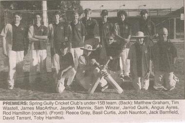
Newspaper - JENNY FOLEY COLLECTION: PREMIERS
Bendigo Advertiser ''the way we were'' from Friday, March 28, 2003. Premiers: Spring Gully Cricket Club's under 15B team. Back: Matthew Graham, Tim Wastell, James MacArthur, Jayden Mannix, Sam Winzar, Jarrod Quirk, Angus Ayres, Rod Hamilton (coach). Front: Reece Gray, Basil Curtis, Josh Nauton, Jack Barnfield, David Tarrant, Toby Hamilton. The clip is in a folder.newspaper, bendigo advertiser, the way we were -
Bendigo Historical Society Inc.
Document - MINER'S RIGHT - MINER'S RIGHT NO 35075 MATTHEW ARBILE
Miner's Right No 35975, dated 6 August 1921, issued to Matthew Arbile (?).The Miner's Right has a crest at the top with a lion and a unicorn beside a shield with a crown on the top. It has 2s. 6d. Printed on each side. Signed by Helen T. Morris. Written on the back is the Situation of Residence Area in Eaglehawk. Printed on the back are Privileges Conferred by a Miner's Right (Subject to the Mining By-laws and for the State of Victoria). Printed on white paper.document, gold, miner's rights, miner's rights, miner's right no 35975 matthew arbile, helen t morris, albert j mullett -
Bendigo Historical Society Inc.
Document - MINER'S RIGHTS - MINER'S RIGHT NO 14628
Miner's Right No 14628, dated 9 August 1914, issued to Matthew Arbile (?).The Miner's Right has a crest at the top with a lion and a unicorn beside a shield with a crown on the top. It has 2s. 6d. Printed on each side. Signed by Helen T. Morris. Written on the back is the Situation of Residence Area in Eaglehawk. Printed on the back are Privileges Conferred by a Miner's Right (Subject to the Mining By-laws and for the State of Victoria). Printed on white paper.document, gold, miner's right, miner's right, miner's right no 14628, matthew arbile (?), helen t morris, albert j mullett -
 Whitehorse Historical Society Inc.
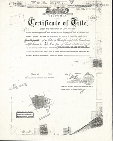
Document, Certificate of Title, 1/11/1913
Photocopy of Certificate of Title Vol 3739 Fol 747798, fifty-five acres fronting Mitcham Road, Vermont being part Crown Portion 121 at Mitcham, Parish of Nunawading, County of Bourke in the name of William George Kirkpatrick and Alfred Matthew Kirkpatrick, 1 November 1913. Transfer to Wunderlich Ltd 31 July 1928; Australian Industry Development Corporation 19 October 1983 and leased to Monier Ltd.kirkpatrick, william george, alfred matthew, wunderlich limited, monier limited, australian industry development corporation, mitcham road, vermont, land sales -
 Ballarat Tramway Museum
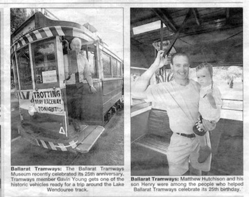
Newspaper, The Courier Ballarat, Celebrating 25th anniversary, 7/01/2000 12:00:00 AM
Newspaper clipping from the Ballarat Courier of 7/1/2000 featuring two photographs taken on 26/12/1999 during the 25th anniversary celebrations of the operations of the tramway by the BTM. Item within the People and places section. The first photo - Gavin Young standing in the doorway of tramcar No. 40. The second - Mr. Matthew Hutchison holding his son Henry inside a tram - possibly No. 13 - see also item 1290. "7 Jan 1999 Courier" in black ink, top right hand corner - date was actually 2000.trams, tramways, btm, visitors, 25th anniversary -
Glenelg Shire Council Cultural Collection
Photograph - Photograph - Fawthrop Lagoon, Portland Victoria, n.d
Black and white photo. Original photo 7731 7731 - Black and white photo of the causeway across Wattle Creek end of Fawthrop Lagoon. Lagoon visible on left. Taken from bottom of Magazine Hill.Back: '56' in pencil -
 Federation University Historical Collection
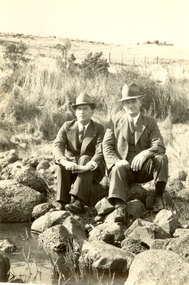
Photograph - Black and White, Frank Wright and Friend, circa late 1920's
Frank Wright was a renown resident of Smeaton, where he was born. He lived at Laura Villa, and attended Smeaton State School. His father William was a gold miner and his mother's name was Sarah. Their family won many singing and instrumental awards. Frank was tutored by Percy Code and was awarded a gold medal for the highest marks in the ALCM examinations in the British Colonies at the age of seventeen years. He became the Australian Open Cornet Champion by the age of eighteen. A year later, Frank conducted the City of Ballarat Band, and later the Ballarat Soldiers’ Memorial Band. He formed the Frank Wright Frisco Band and Frank Wright and his Coliseum Orchestra. These bands won many South Street awards, and Frank as conductor won many awards in the Australian Band Championship contest. In 1933 Frank Wright sailed to England to conduct the famous St Hilda’s Band and was later appointed Musical Director of the London County Council, where he organized many amazing concerts in parks, in and around the London district. He was made Professor of Brass and Military Band Scoring and conducted at the Guildhall of Music and Drama. Frank was often invited to adjudicate Brass Band Championships around Europe, in Australia, including South Street and in New Zealand. The Frank Wright Medal at the Royal South Street competition is awarded to an individual recognized as making an outstanding contribution to brass music in Australia.Black and white photograph of two men dressed in suits and hats, sitting on rocks beside a creek in a grassy paddock, with a post a wire fence in the background. The man on the left is Frank Wright. The man on the right is unknown.Printed on back - SELOfrank wright, ballarat, cornet, conductor, smeaton -
 Bendigo Historical Society Inc.
Slide - DIGGERS AND MINERS. DIGGERS AND MINERS, c1851
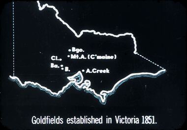
Diggers and miners. Diggers and Miners. Map of Victoria shows Bgo. Mt. A. (C'maine) Cl. Ba. B. A. Creek. Goldfields established in Victoria 1851. Markings: 11 994.5 WAL. Used as a teaching aid.hanimounteducation, tertiary, goldfields -
 Bendigo Historical Society Inc.
Slide - DIGGERS AND MINERS. DIGGERS AND MINERS, 1850s
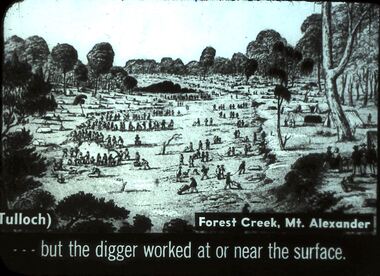
Diggers and miners. Diggers and Miners. (Tulloch) Forest Creek, Mt. Alexander . . . But the digger worked at or near the surface. Picture shows lots of diggers at work. Markings: 4 994.5 WAL. Used as a teaching aid.hanimounteducation, tertiary, goldfields -
 Bendigo Historical Society Inc.
Slide - DIGGERS & MINING. DIGGERS AND MINERS, 1850s
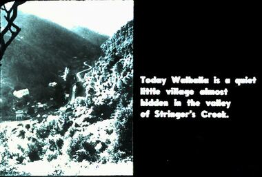
Diggers & Mining. Diggers and Miners. Today Walhalla is a quiet little village almost hidden in the valley of Stringer's Creek. Photo shows the town in the valley. Markings: 60 994.5 WAL. Used as a teaching aid.hanimounteducation, tertiary, goldfields -
 Bendigo Historical Society Inc.
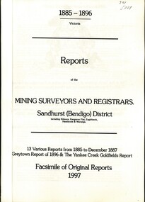
Book - REPORTS OF THE MINING SURVEYORS AND REGISTRARS 1885 - 1896, 1997
Reports of the Mining Surveyors and Registrars. Sandhurst (Bendigo) District. 13 various Reports from 1885 to December 1887 Greytown Report of 1896 and the Yankee Creek Goldfields Report. Facsimile of Original Reports 1997.goldfields, mining reports -
 Clunes Museum
Photograph
PICTURED, L -R HARRY PICKFORD, HARRY ROBINSON, BILL ROBINSON SENR. COLIN DRIFE, FRANK CARROLAN, JACK KIERCE, AND GEORGE DRIFE. ORIGINAL PHOTOGRAPH OWNED BY MR. MICHAEL KIERCE.PHOTOCOPY OF PHOTO OF OPENING OF BRIDGE OVER MOUNT CREEK CIRCA 1941, SHOWING HARRY PICKFORD, HARRY ROBINSON, WILLIAM ROBINSON SNR., COLIN DRIFE, FRANK CARROLAN, JACK KIERCE, GEORGE DRIFE.local history, photography, photographs, bridges -
Whitehorse Historical Society Inc.
Postcard - Illustration, Heidelberg School
Folio of coloured postcards of artists paintings from the Heidelberg School. The Heidelberg School set up tents in 1885 on land belonging to David Houston on Gardiner's Creek. Included is a history on each artist and painting.heidelberg school, davies, david, conder, charles, phillips, fox emanuel, mccubbin, frederick, roberts, tom, streeton, arthur, sutherland, jane, withers, walter, alston, alby, box hill artists camp -
Whitehorse Historical Society Inc.
Map, Environment effects statement, 1/03/1979 12:00:00 AM
Diamond Creek-Ringwood study: Planning Scheme reservations and zones with recommended concept.Diamond Creek-Ringwood study: Planning Scheme reservations and zones with recommended concept. City of Nunawading: section north of Canterbury Road. Scale 1:25,000 metric. Map B with drafting ref. no. 145Diamond Creek-Ringwood study: Planning Scheme reservations and zones with recommended concept. city of nunawading, land use, melbourne metropolitan planning scheme -
 Lakes Entrance Regional Historical Society (operating as Lakes Entrance History Centre & Museum)
Photograph, Bennett, Vera, 1989
Date made June 1989|Two photographs taken by Vera Bennett| One photograph taken by Keith Scarce|Six photographs all similar views of trestle bridgeColour photograph of the trestle railway bridge over Stoney Creek, near Nowa Nowa, showing bridge in intact condition soon after the cessation of services from Bairnsdale to Orbost. Nowa Nowa Victoriabridges, transport -
 Lakes Entrance Regional Historical Society (operating as Lakes Entrance History Centre & Museum)
Photograph, 1993
Black and white photograph two students Rae Robins Swift Creek and Wendy Whitford Orbost at TAFE Outreach taking part in Media Skills workshop, East Gippsland Access Project. Gippsland Victoriaeducation -
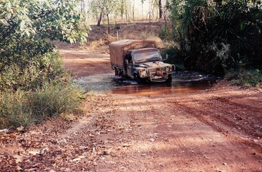 8th/13th Victorian Mounted Rifles Regimental Collection
Photograph
The Dibb Report into mainland defence of Australia,1986, among other things identified the requirement for protection of key assets in Northern Australia and the possibility of involving Army Reserve (Ares) units in this thus releasing regular forces for offensive operations. Dibb also pointed out that this defined role would result in a huge lift in Ares morale. In June 1988, the 3rd Division (3Div) conducted a Tactical Exercise without Troops (TEWT), Exercise ‘Distant Trumpet’ in the Katherine- Darwin area to study problems associated with defence against low level incursions against Tindal RAAF Base. Exercise ‘Northern Explorer’ followed in October of that year when units of the 3Div including A Squadron 8/13 Victorian Mounted Rifles sent patrol groups to get a first taste of environment and conditions. Post-Exercise reports had to include recommendations re: health, equipment and adaptation of Standing Operating Procedures (SOPs) in preparation for the new role deploying to Northern Australia. The first deployment by 8/13 Victorian Mounted Rifles was in 1988. Deployments continued in following years. In September 1993, 3 Troop (Wangaratta) VMR Squadron 4/19 PWLH commanded by Captain Kelvin Robertson deployed to NT. The training began with airfield defence at Tindal followed by a 1000km recon into Arnhem Land in four Landrovers. The troop reported on the conditions of the roads, airfields, bridges (mainly causeways) resources such as fuel supplies in the towns and infrastructure. Each troop taking different route. 3 Troop had the Northern route through Kakadu National park across the East Alligator River to Oenpelli then to Maningrida and Ramangining and south to the Central Arnhem Road and back to Tindal Air force Base. Two colour photographs of creek crossings, one more challenging than the other,during the annual exercise in Northern Territory, conducted by VMR Squadron 4/19 Prince of Wales's Light horse, 1994. -
Southern Sherbrooke Historical Society Inc.
Plan - Plans for Proposed Sports Pavillion and Scout Hall at Menzies Creek
Two copies of sketches for a proposed sports pavilion and Scout Hall at Menzies Creek, from multiple angles (front, side and rear). All sketches are at 1:100 scale. Includes floor plan of the building. -
 Southern Sherbrooke Historical Society Inc.
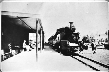
Photograph - Photo, Menzies Creek Station
Photograph of Gembrook train (Puffing Billy) arriving at Menzies Creek Train Station from Belgrave. A woman and a man (?) are seated at the station. Two boys run along the far side of the track. Date unknown, -
 Southern Sherbrooke Historical Society Inc.
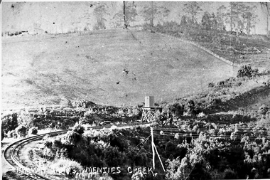
Photograph - Photo-black & white-Puffing Billy track and water tower
Photograph of the railway line to Gembrook and the water tank at Menzies Creek in the centre of the picture. This area, known as The Tanks, is the site of the landslide that closed the railway down in 1953. Glen Park homestead is on top of the hill on the left. -
 Southern Sherbrooke Historical Society Inc.
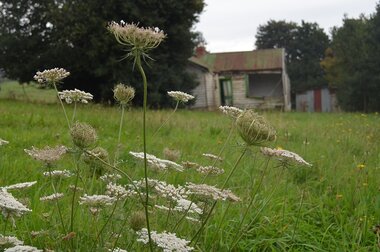
Photograph - Photos of house and land at 12c Black Hill Rd, Menzies Creek
Photographs of the house and land at 12c Black Hill Rd, Menzies Creek, taken by Chris Girvan in 2011. Features the run-down, abandoned interior and exterior of the house (missing glass pane windows), and shed. -
 Bendigo Historical Society Inc.
Slide - DIGGERS & MINING. DIGGERS AND MINING, c1852
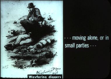
Diggers & Mining. Diggers and miners. - - - moving alone, or in small parties - - - Slide: STG Wayfaring Diggers 1852. Two diggers resting by a creek. Markings: 40 994:LIF I. Used as a teaching aid.hanimounteducation, tertiary, goldfields -
Tarnagulla History Archive
Christopher letter, 1860 (original letter)
Donald Clark Collection.Two identical photocopies of a four-page letter written by a resident of Sandy Creek (Tarnagulla). Appears to be from a person with surname Christopher to a Miss Mary Christopher (the author's sister). Dated April 16, 1860. -
 Halls Gap & Grampians Historical Society
Photograph - Sepia, C 1909
Grampians halls Gap at Stoney Creek Dredge. The site of the Stoney Creek diggings was in the upper catchment area of the creek, beside Silverband Road. For further information see: 'Bridging the Gap' by Ida Stanton, p. 49 and 'Victoria's Wonderland' by Halls Gap and Grampians Historical Society, p. 41.Photo shows eight men seated, two standing, 3 tents in background. 2nd right Alfred D'Alton 4th Right James Oliverwater supplies, d'alton, water supplies, channels -
 Eltham District Historical Society Inc
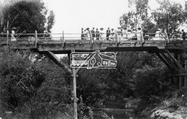
Negative - Photograph, Hurst's Bridge, c.1912
The area of Hurstbridge was originally known as Hurst’s-bridge after the timber bridge built over the Diamond Creek near Hurst’s station in late 1881/early 1882. A large group of people can be seen strolling across the timber bridge over the Diamond Creek on Hurstbridge-Arthurs Creek Road, Hurstbridge. It was built by John McDonald, of Arthur's Creek and was demolished and replaced in 1917 by a reinforced concrete arch bridge designed by John Monash.This photo forms part of a collection of photographs gathered by the Shire of Eltham for their centenary project book, "Pioneers and Painters: 100 years of the Shire of Eltham" by Alan Marshall (1971). The collection of over 500 images is held in partnership between Eltham District Historical Society and Yarra Plenty Regional Library (Eltham Library) and is now formally known as 'The Shire of Eltham Pioneers Photograph Collection.' It is significant in being the first community sourced collection representing the places and people of the Shire's first one hundred years.Digital image 4 x 5 inch B&W Negshire of eltham pioneers photograph collection, 1912, bridge, diamond creek (creek), hurstbridge, hurst's bridge -
 Falls Creek Historical Society
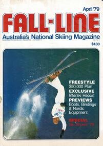
Magazine - Fall-Line - Australia's National Skiing Magazine April '79, April '79
“Fall-Line” was one of a series of magazines published by the Victorian Ski Association. It was produced from 1979 until 1985. It superseded their previous publication, “Ski” magazine and was followed by the “Australian Skiing” magazine. The Victorian Ski Association was formed in 1955.This magazine is significant because it documents developments in the ski industry in Australia.A magazine featuring a coloured image on the cover and containing articles and advertising related to developments in skiing in Australia. This issue included an update on improvements being made at Falls Creek. FALLS CREEK The chairlift access area near the medical centre, long famous as the Mudpie Parlour of Falls Creek, has been sealed and Falls Creek itself, the waters of which have filled many an unsuspecting gum- boot, has been bridged, also near the medical centre. A lock-up storage shed will be built along Bogong High Plains Road, just below the oversnow terminal, for the use and convenience of all village commercial operators and site holders. Direct access will be possible by snowmobile. Falls Creek rates have risen to $82.50 per bed (less 10% discount if paid on time). The rise is the first in two years, and is less than the corresponding rise in the C.P.I. over that period. The access trail from the water tanks at the base of the Home Trail to the nursery slope has been smoothed and widened to 12 metres, and a new six metre wide access trail has been cut from Falls Creek Road, just behind Diana lodge to the chairlift bottom station. The Village Bowl comfort station is being extended and renovated, and the finishing touches are being put on the comfort station in the upper car park. Construction of an akja station/toilet block in Sun Valley will commence in 1980. The Management Committee is investigating the purchase of a Mercedes 800 series snow-clearing machine to supplement the CRB equipment in use in village parking areas The village water supply has been re- designed to ensure adequate supply at all times.australian ski magazines, skiing australia, victorian ski association