Showing 27535 items
matching yarra-river
-
 Lakes Entrance Regional Historical Society (operating as Lakes Entrance History Centre & Museum)
Photograph, 1957
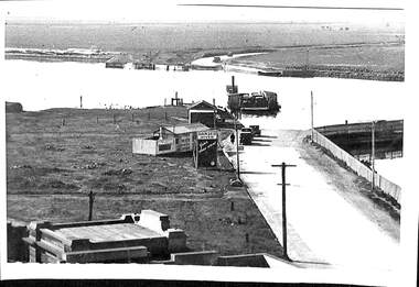
Photograph taken with olde Brownie Box camera January 1957.Black and white photograph of Mitchell River silt jetties taken from cliff at Eagle Point Victoriawaterways -
Lakes Entrance Regional Historical Society (operating as Lakes Entrance History Centre & Museum)
Photograph, 1940 c
No 4 in series of fiveBlack and white photograph of workmen with horses and scoops opening an entrance at mouth of the Snowy River Marlo Victoriaenvironment, waterways, public works -
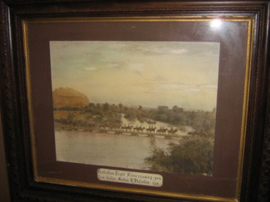 Kyneton RSL Sub Branch
Framed photograph, Australian Light Horse 1918
Sepia photograph of the Australian Light Horse crossing a pontoon bridge over Jordan River, Palestine, 1918.Plaque on frame below photograph.. -
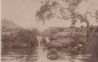 Sunbury Family History and Heritage Society Inc.
Photograph
The Mill Falls are downstream on the Jacksons Creek from the Macedon Street bridge in Sunbury.A sepia photograph in post card format of a river with a waterfall. A straggly tree is growing on the bank on the RHS of the photograph.MILL FALL/ SUNBURYjacksons creek, mill falls, sunbury -
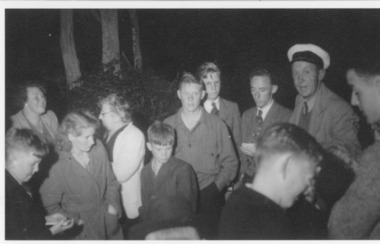 Lakes Entrance Regional Historical Society (operating as Lakes Entrance History Centre & Museum)
Photograph
Black and White photography of a crowd at a Pig-Roast Night for LEFC Tambo River, Keith Drevermann (in cap)clubs, sports -
Glenelg Shire Council Cultural Collection
Plan - Plan - Port of Portland Authority Slipway, Bilge Blocks Trawler, Bow River, 12/05/1988
Front: '10' - black texta, top right corner 'Job no. 3081' black inkport of portland -
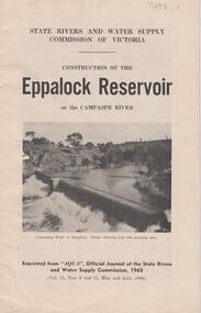 Bendigo Historical Society Inc.
Document - EPPALOCK RESERVOIR ON THE CAMPASPE, STATE RIVERS AND WATER SUPPLY 1960
Booklet, 23 pages, detailing the construction of the Eppalock Reservoir. Printed on front cover 'State Rivers and Water Supply Commission of Victoria. Construction of the Eppalock Reservoir on the Campaspe River'. Photograph on front cover shows the Campaspe River at Eppalock. Water flowing over the existing weir. Information contained in the booklet pertains to the history of weirs along the Campaspe and the development of the Eppalock project. Black and white photos of opening ceremony of build and historical photos of weirs.bendigo, waterworks, eppalock weir -
 Kew Historical Society Inc
Photograph - Willsmere [Kew] Billabong, 1993
Willsmere Park is bounded by the the Yarra River, Green Acres Golf Club, Willow Grove and the Eastern Freeway. The land on which the park is now situated was bought by Thomas Wills at the Crown Land Sales of 1846 (Section 56). From the 1840s to the 1940s it was intensively farmed. The park is dominated by very large playing fields, while planting to the southern boundary was undertaken when the Eastern Freeway was built. It is only along the banks of the Yarra that there is any remnant native vegetation. Willsmere Park is of significance as an area of open land that remains from the flood plain that once dominated northern Kew. (Source: Kew Conservation Study, 1988)Original colour small format polaroid photograph of the 'Kew Billabong' in the Willsmere Park, taken on 16 September 1993."Willsmere Billabong 16.9.93"kew billabong, willsmere park, yarra river -- billabongs -
 Kew Historical Society Inc
Photograph - Flooding in the Willsmere Park, 1993
Willsmere Park is bounded by the the Yarra River, Green Acres Golf Club, Willow Grove and the Eastern Freeway. The land on which the park is now situated was bought by Thomas Wills at the Crown Land Sales of 1846 (Section 56). From the 1840s to the 1940s it was intensively farmed. The park is dominated by very large playing fields, while planting to the southern boundary was undertaken when the Eastern Freeway was built. It is only along the banks of the Yarra that there is any remnant native vegetation. Willsmere Park is of significance as an area of open land that remains from the flood plain that once dominated northern Kew. (Source: Kew Conservation Study, 1988)Original colour small format polaroid photograph of flooding in the Willsmere Park, taken on 16 September 1993."Flooding of shared path from Willsmere Billabong 16.9.93"willsmere park, yarra river -- floods -- kew (vic.), kew billabong -
 Kew Historical Society Inc
Photograph - Willsmere [Kew] Billabong, 1993
Willsmere Park is bounded by the the Yarra River, Green Acres Golf Club, Willow Grove and the Eastern Freeway. The land on which the park is now situated was bought by Thomas Wills at the Crown Land Sales of 1846 (Section 56). From the 1840s to the 1940s it was intensively farmed. The park is dominated by very large playing fields, while planting to the southern boundary was undertaken when the Eastern Freeway was built. It is only along the banks of the Yarra that there is any remnant native vegetation. Willsmere Park is of significance as an area of open land that remains from the flood plain that once dominated northern Kew. (Source: Kew Conservation Study, 1988)Original colour small format polaroid photograph of Willsmere [Kew] Billabong on September 1993."Willsmere Billabong 16.9.93"yarra river -- floods -- kew (vic.), willsmere park -
 Kew Historical Society Inc
Map, MMBW, MMBW Plan No.68 Kew, 1900-1910
The Melbourne and Metropolitan Board of Works (MMBW) was established by an act of the Victorian Parliament in 1890 to prepare for and to implement a sewerage and water reticulation system across what was then inner Melbourne, its surrounding and middle distance suburbs, including Kew. The MMBW was disbanded in 1991.The map collection of the Kew Historical Society has at its core the historic maps assembled and originally stored in the City Engineer's Department of the City of Kew. These include maps in a number of scales. The vast majority of maps were produced by the MMBW in the first two decades of the twentieth century, and are solid working maps, backed by linen for durability. These maps are historically significant to Kew, the City of Boroondara and to the history of the development of state utilities in Victoria. A number of the Kew maps have additional details added by former municipal officers, including the levels reached by various floods. As these were working documents, information was added to them long after the period of their initial production and distribution.Early map of part of the Borough of Kew, created in the first decade of the twentieth century, at a scale 160 ft to 1 inch. The map covers what was then the north central part of Kew, bordered in the north by Oak Avenue, in the west by the Yarra River and Connor's Creek, in the south by Beresford and Carnegie Avenues, and in the east by Glass's Creek and Burke Road. The map shows the extent of urban development by that time, prominent institutions and the outlines of built structures in the municipality. Contour lines and the levels of historic floods were added in ink to the map at a later stage.MELBOURNE AND METROPOLITAN BOARD OF WORKS / PLAN NO. 68 / KEW melbourne & metropolitan board of works, mmbw maps, mmbw plans, borough of kew, cartography -
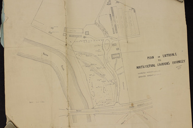 University of Melbourne, Burnley Campus Archives
Plan, Plan of Entrance to Horticultural Gardens Burnley, 1932
Copy of plan photographed at the Public Records Office Victoria. (1) Hand drawn plan signed by A.W. Jessep 8/12/32 with 'Suspected Roadway' and ' Suggested Roadway'. Scale 1 inch - 1 chain. Trees on East side named. (2) Memorandum to The Agricultural Superintendent dated 08.12.1932 'Re Proposed Boulevard Along the River Yarra' from the Principal A.W. Jessep. Plan had been to put road through the Lagoon Paddock and he suggested the route outside the Burnley College grounds.prov, burnley gardens, a.w. jessep -
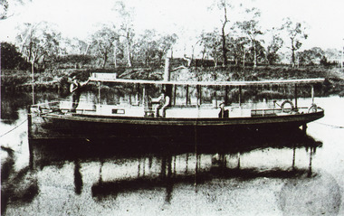 Lakes Entrance Regional Historical Society (operating as Lakes Entrance History Centre & Museum)
Photograph, 1895 c
.Bairnsdale 1884 by S Erikson.Black and white photograph of S S Ariel moored in Mitchell River. Captain James Bull at wheel. Alan Anderson engineer and another man on board. High timbered bank on opposite side of river. Boat dark coloured with light coloured top. Bairnsdale Victoriaships and shipping, jetties, retail trade -
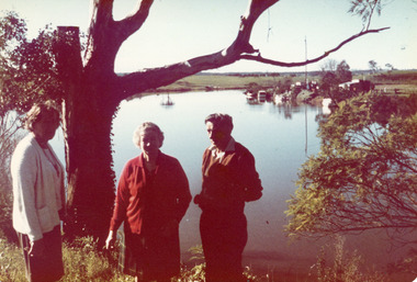 Lakes Entrance Regional Historical Society (operating as Lakes Entrance History Centre & Museum)
Photograph, 1974
Colour photograph showing Jean Wilton and Eileen Potter visitors from New Zealand and George Legg of Bairnsdale standing beside the Tambo river. Both women were daughters of Captain Bob Duncan of Burrabogie which plied the Tambo river and the lakes. Johnsonville Victoriagenealogy -
 Upper Yarra Museum
Negative Photographic Reproduction, Hilditch family Hazelwood, Warburton East
03029 Hilditch family Hazelwood, Warburton East Upper Yarra Shire 1888-1988 Centenary collection. Negative, Black & white. Scanned at 600 dpihilditch family hazelwood warburton east -
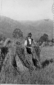 Upper Yarra Museum
Negative Photographic Reproduction, Stacks of Hay - C McCrae Wesburn
03032 Stacks of Hay - C McCrae Wesburn Upper Yarra Shire 1888-1988 Centenary collection. Negative, Black & white. Scanned at 600 dpistack of hay c mccrae wesburn -
 Port Melbourne Historical & Preservation Society
Photograph - Short Road ferry crossing Yarra from west side, 1930
Black and white photograph of Short Road ferry crossing the Yarra, taken from the west side. Roads on both sides with cars. Buildings on west side.piers and wharves, short road ferry, williamstown road -
Port Melbourne Historical & Preservation Society
Accessory - Tie clasp, Port Melbourne Bowling Club, A J Parkes, c. 1975
Collected by Fred WINDUSSPort Melbourne Bowling Club tie clasp, design in navy blue, red, gold and aquamarine appears to be Yarra and West Gate Bridge; irregular shapesocieties clubs unions and other organisations, sport - lawn bowls, frederick robert winduss, port melbourne bowling club -
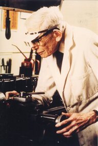 Geoffrey Kaye Museum of Anaesthetic History
Photograph - Photograph, Geoffrey Kaye
Photograph has been taken in Geoffrey Kaye's later years, approximately late 1970s or early to mid 1980s.Large colour photograph of an elderly Dr Geoffrey Kaye wearing a white dustcoat and working on his lathe at his Cromwell Road, South Yarra home.geoffrey kaye, metal lathe, workshop -
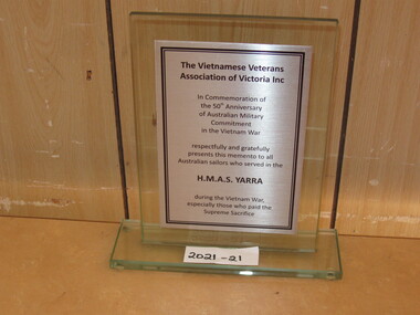 National Vietnam Veterans Museum (NVVM)
Plaque, The Vietnamese Veterans Association of Victoria Inc
A glass commerative plaque presented by The Vietnamese Veterans Association of Victoria Inc in Commeration of the 50th Annisversary of Australian Military Commitment in the Vietnam War by HMAS Yarraglass plaque, hmas yarra, cerberus collection -
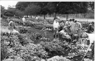 University of Melbourne, Burnley Campus Archives
Photograph - Black and white print, Publicity Branch, Department of Agriculture, Victoria, Students Weighing Produce, 1964-1965
Note by T.H. Kneen 18 December 1991, "The students are engaged in weighing produce from individual student plots. The dark haired female student is Lauris (or Loris) Inglis a 1966 graduate. Plots were a feature of the second year therefore the photo is probably 1965."Black and white photograph. Group of students working in the vegetable plots and bringing their produce to be weighed. One student spraying his crops. Yarra Boulevard in the background. On reverse stamp, "Photograph by Publicity Branch Victorian Department Of Agriculture Ref. No. D521F".students, female students, lauris inglis, loris inglis, weighing produce, orchard, students working outside, vegetable plots, spraying, yarra boulevard, publicity -
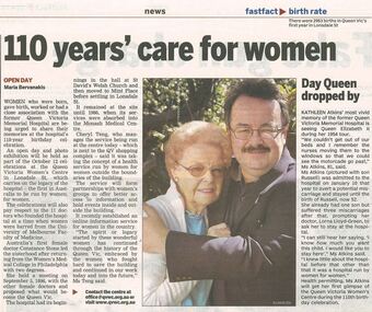 Queen Victoria Women's Centre
Newspaper excerpt, 110 years' care for women and Day Queen dropped by, 4 October 2006
Newspaper article Melbourne Yarra Leader page 4. Colour photograph portrait of two people looking towards the camera, Kathleen Atkins and Russell Atkins. official event, charitable organisation, hosptial, historic buildings, women's history -
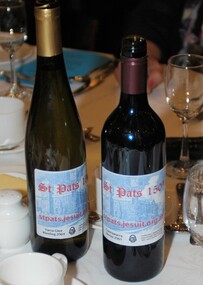 St Patrick's Old Collegians Association (SPOCA)
Photograph - History, SPJC, General
-
 Robin Boyd Foundation
Painting, Asher Bilu, Solstar, 1968
Robin Boyd most likely saw Solstar at Asher Bilu's exhibition at South Yarra Gallery in September 1968. In November 1968, Robin Boyd arranged for the loan of this painting from South Yarra Gallery to Australian Pavilion at Expo '70 in Osaka, where Boyd was appointed Exhibit Architect. It hung in the bedroom over a bed, containing a life-size cut-out figure by Bruce Petty, in the Model House Interior exhibit on modern living in the Space Tube. On its return from Expo, the painting was in transit at the Boyd's home in Walsh Street and they liked it so much that they decided to buy it. Solstar originally hung on the wall at the end of the galley kitchen. The artwork at the Boyd's home in Walsh St has been moved several times over the years. Solstar now hangs above the dining table, but at the time of Solstar's acquisition, the Boyds hung the painting "Winter Triumphant" (1920) by Penleigh Boyd, Robin Boyd’s father, above the dining table. In early 2021, Asher and Luba Bilu visited Walsh St to view Solstar again. Asher was extremely happy with how the painting looked and its condition 53 years after painting it. He requested it be hung a little higher and he returned in April to make some minor restorations to remove scratches. Silver mixed media with large black circular area in the central lower half. On reverse has the title: Solstar/A. Bilu/Arrow showing which way up. Unsigned on the front.asher bilu, penleigh boyd, expo 70, osaka, robin boyd, south yarra gallery, walsh st artwork, ohm2022, ohm2022_13 -
 Kyneton RSL Sub Branch
Framed portrait photograph
Studio photographic portrait. Subject unknown.Portrait Painters Walsh Bros 297 Malvern Rd. South Yarra. Marked: 607 Kyneton , on back -
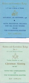 Bendigo Historical Society Inc.
Document - LODGE COLLECTION: ONE CARD GOOD WISHES AND ANOTHER OF CHRISTMAS MEETING, 18th Sept and 14th Dec
Lodge documents. Card sending fraternal good wishes and another re the Christmas meeting. Golden and Corinthian Lodge No. 7.Novelty folder supplied by, The Russel Printing Concern 417-419 Chaple Street South Yarra, Melbourne.clubs, social, wishing and compliments cards -
Eltham District Historical Society Inc
Document - Folder, Newman, Charles
British army officer Major Charles Newman was an early settler on the Yarra River at Templestowe after serving in India in the East India Company. Later be married and moved to Tasmania, farming at Black Brush near Pontville. In 1835 he came to the Port Phillip District and explored the Yarra River, returning with his family. David Crockett and Hazel Poulter researched, respectively, Charles Newman and the Templestowe area, identifying the Newman house, Pontville, on the Yarra banks. David Crockett also researched James and Anne Anderson. Contents Newspaper article: "David fills in the gaps", Diamond Valley News, 16 December 1986.29 October 1985, p62. Story of Charles Newman and of David Crockett and Hazel Poulter's researches. Letter, A (Tony) B Owen to Eltham Historical Society, 12 March 2018, enclosing information about Major Charles Newman. Email, Eltham District Historical Society to Tony Owen, acknowledging receipt of information about Major Charles Newman. Photocopy of pages from "Glimpses of Life in Victoria", pp38-43. Flier, "Heritage Events in Nillumbik, 2005". Photocopy of pages from unidentified volume, chapter headed "The Bush", and part chapter IV "Bushrangers". Warrandyte Historical Society publication "The Wurundjeri Clan of the Kulin". Whitehorse Manningham Heritage Network search results for "Andersons Station on the Yarra Yarra", "A brief history of Warrandyte", "The branch is broken", "Melbourne's historic home", "Land with infamous past", "Charles Newman's original grave at Monckton", and "Site of Major Newman's land". Photocopy of pages from "Templestowe - a folk history", Hazel Poulter, 1985,: "The squatter, Major Charles Newman".Newspaper clippings, A4 photocopies, etccharles newman, british east india company, templestowe vic, warrandyte vic, david crockett, hazel poulter, james anderson, anne anderdon, a b owen, wurundjeri clan of the kulin, andersons station on the yarra river -
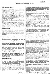 Greensborough Historical Society
Article - Article, Newsletter, Janeen O'Connell, William and Margaret Blay, by Janeen O'Connell, 2022
The Blays moved from their farm in New Norfolk, Van Diemens Land to an allotment at Greenhills on the Plenty River in 1841, but William was injured in a fall and was unable to work this farm, which was repossessed by the bank, causing him to fall into a severe depression and subsequently admitted to Yarra Bend Insane Asylum, where he died in 1849. Article first published in "Pioneer Echo" no 226, Oct-Nov 2022.1 p. typescript, copied from newsletterblay family, william blay, greenhills -
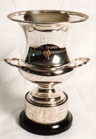 Royal Brighton Yacht Club
Cup, Alan Robinson Memorial Trophy (Cup)
Alan Robinson Memorial Trophy (Cup) Donor : Keith Farfor Deed of Gift: No Alan Robinson was the navigator on Keith Farfor’s yacht Super Star. He was killed in a car accident on the banks of the Yarra River. The race is a combined division race from RBYC to the QCYC. The trophy is awarded to the PHD handicap winner and is raced early June of each year. First Winner: Bindi D Buxton alan robinson, memorial, trophy, phd, combined division -
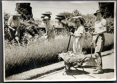 University of Melbourne, Burnley Campus Archives
Album - CD black and white and sepia prints, Hilda Dance, 1935-1936
Hilda Dance (graduated 1936, staff 1941-47)2 copies of a CD with photographs taken by Hilda Dance. (1) 4 female students working in a flower bed. (2) 6 students at a flower show. (3) 4 female students on the lawn wearing dresses. (4) Group of students sitting on benches on the lawn. (5) 1936 Year Group. (6) 4 female students playing around on the lawn. (7) Students working near the Luffmann Ponds. (8) Newspaper cutting: 'She knows all the answers.' Student answering questions on a Vegetable Growing public day. (9) 2 female students playing around on the lawn. (10) Possibly an excursion to the zoo-man holding snake. (11) Female student bathing in the Yarra River. (12) Female student climbing a tree with steps cut into it, not Burnley. (13) Students bathing in the Yarra River. (14) 4 female students on the lawn wearing dresses. (15) Group of male students with lawnmower. (16) George Barnett/Russ? (17) Female student watering seedlings. (18) Group of male students with lawnmower. (19) Orchard Border. (20) Group of male students with lawnmower.hilda dance, female students, flower beds, students, flower show, luffmann ponds, students working outside, recreation, lawnmower, tree climbing, george barnett, orchard border