Showing 10951 items matching " land"
-
 Orbost & District Historical Society
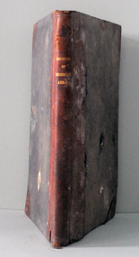
register, Register of Residence Areas, 10.2.1897 - 4.9.1934
This book is a register of land holders with miners' rights. The correspondence is associated with applications for miners' rights on privately owned land and business sites. They include application fotrms and objections to registrations. The areas referred to are Combienbar, Goongerah, Club Terrace, Wombat Creek and Dundong. One of the privileges under the Mines Act, conferred by the holding of a miner's right until 1935 was that of residence on up to one acre on a gold-fields area. Those occupying a residence area were "deemed in law to be possessed ... of such ... parcels ... and the property therein".This is a useful research tool.A large, heavy book with a grey cloth cover and red spine. The end papers are marbled. The inside pages are ruled in grey with red ruled columns. Entries are hand-written. There are copies of correspondence inside. Details given are the registration number and date, the name of the person, the number of the miner's right and its date, a description of the allotment and any remarks or references to other volumes. Any changes of ownership are shown. The book is mostly unused.register-mining miners-rights -
 Torquay and District Historical Society
Photograph (copy), Bellbrae Cemetery Memorial Exhibition 2015
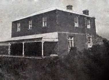
Photograph shows Llanberris House, built by Joseph and Mary Gundry on Iron Bark Station, west of the Anglesea Geelong Road, off Menzels Road above Spring Creek. The Gundrys took up Iron Bark station in 1844 and subsequently bought up more surrounding land. Just prior to Joseph's death in 1878, the property comprising 7721 acres was offered for sale as well as conditional rights to adjoining land. Llanberis House was a substantial stone dwelling of 2 storeys with 11 rooms.The Gundry family was one of the pioneering European settlers in the Bellbrae Torquay area.Black and white photographbellbrae victoria pioneer families -
 Whitehorse Historical Society Inc.
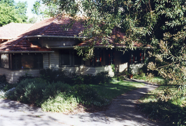
Photograph, 443 Mitcham Road, Mitcham, 1998
Eric Roger Webb moved to Mitcham with his family in about 1932. They lived at 443 Mitcham Road and owned all the land up to Simpson Street. The land was a grass paddock and he planted native trees and shrubs around the perimeter. The Webbs has three children: Eric, Dean and Donald. Mr Webb worked in the public service. He was a councillor of the Shire of Blackburn and Mitcham and later of the city of Nunawading between 1940 and 1949. He was also a Shire President from 1943-1944.Coloured photograph of a house at 443 Mitcham Road, Mitcham. Tiled roof, verandah, path leading to front door.443 mitcham road, mitcham, houses, webb, eric -
 Bendigo Historical Society Inc.
Document - Fortuna Villa - The Past and the Future
Theodore Batterstedt and his father bought five acres of land on which they built a quartz crushing mill and a two storied, 8 roomed home in 1855. In 1869 they added 2 large rooms to each floor. In 1870 they sold the property to George Lansell. Further additions and renovations too place in 1888' 1890, 1900 and 1907. In 1942 the largely derelict building was compulsorily acquired by the army to house the Land Headquarters Cartographic Company and later the Army Survey Regiment.A 2 page document detailing the history of George Lansell's 'Fortuna' estate.george lansell, fortuna, military -
 Kew Historical Society Inc
Map, Robert Russell, Map Shewing the Site of Melbourne and the Position of the Huts & Buildings Previous to the Foundation of the Township by Sir Richard Bourke in 1837
Map shows the first layout of Melbourne by Government surveyor Robert Russell, who accompanied Governor Richard Bourke in 1837. The surveyed blocks extend from present-day Flinders Street to Lonsdale Street, and Spring Street to Spencer Street, with extensive vacant land west to a salt lake (afterwards Batman's Swamp, later drained), north beyond Flagstaff Hill and south towards South Melbourne. Vegetation coverage is indicated, and tracks and existing buildings and cultivated land are shown.Printed map was created by Day & Haghe, Lithographers to the Queen, sometime after 1838, when the company received its Royal appointment. Copies of the 1837 map exist in several major map collections in Australia; most are uncoloured. This particular map is the earliest in the Kew Historical Society's map collection. It is a nationally significant artefact. Black and white lithographed map hand-coloured in blue and yellow gouache of the town of Melbourne in 1837. In contrast to the original lithograph, the river and the township blocks are coloured blue and yellow. A similar, partly coloured copy is in the collection of the University of Melbourne.maps - melbourne - 1830s, governor sir richard bourke, robert russell - surveyor, cartography -
 Bacchus Marsh & District Historical Society
Map - Land Sales Plan, Grantbank Estate Bacchus Marsh, 1924
The Grantbank Estate was a parcel of land close to the centre of the shopping area of Bacchus Marsh which was sub-divided and offered for sale in 58 lots on the 13th September, 1924. It comprised an area of 15 acres, being a portion of the Millbank Estate which had been in the hands of the Grant family for 75 years. The lots had frontages to Gisborne Road, Patterson, William and Sutherland Streets. This was a significant sub-division of land and represented a major expansion of residential housing in Bacchus Marsh in the early 20th century.This land sale map is a typical example of housing estate land sales advertising maps produced by real estate agents in this era. The map is significant for the detailed information it provides about when and where land was sold for new housing estates in Bacchus Marsh in the early twentieth century.Printed paper mapland sales bacchus marsh, land subdivsion bacchus marsh, housing estates land sales bacchus marsh, grant family bacchus marsh -
 The Beechworth Burke Museum Research Collection
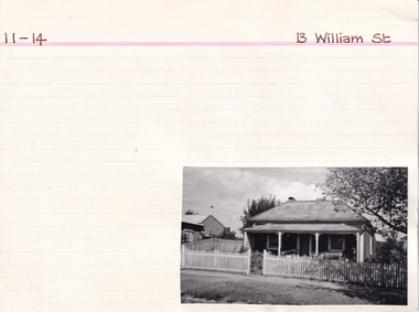
Card (Series) - Index Card, George Tibbits, 13 William Street Beechworth, 1976
George Tibbits, University of Melbourne. Faculty of Architecture, Building and Town & Regional PlanningIndex system that support the research for Beechworth : historical reconstruction / [by] George Tibbits ... [et al]Arranged by street names of BeechworthEach index card includes: street name and number of property, image of property, allotment and section number, property owners and dates of ownership, description of the property according to rate records, property floor plan with dimensions.beechworth, george tibbitsbeechworth, george tibbits -
 Linton and District Historical Society Inc
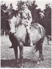
Photograph, Gordon Clarke on his Birthday Pony
Gordon Clarke (1906-1996) was the grandson of David Clarke who bought Piggoreet West in 1855. His parents were John Clarke and Mary Jane Newcomen. Gordon Clarke purchased land between Piggoreet and Linton, known as the 'Bird Paddock', and began to intensively plant indigenous species, with a view to providing habitat for native birds. This land was afterwards expanded and is now known as the Clarkesdale Bird Sanctuary. In the 1970s, Gordon donated the sanctuary to the Bird Observers Club of Australia.Black and white copy of original photograph a boy sitting bareback on a horse with no bridle.horses, gordon clarke -
 Warrnambool and District Historical Society Inc.
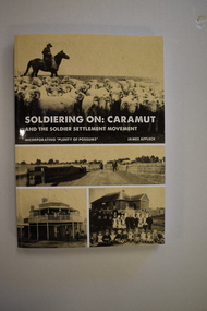
Book, StarPrinting Service Pty ltd, Soldiering On – Caramut and the Soldier Settler Movement, 2018
This book records the history of the post World War Two soldier settlement farms in the Caramut area. Number two in a series of books on Soldier Settlements in Western Victoria.This is a soft cover book of 315 pages. It has a buff-coloured cover with black and white photographs and white printing on the front cover and black printing on the spine. The book includes printed material, black and white photographs, maps and plans. non-fiction This book records the history of the post World War Two soldier settlement farms in the Caramut area. Number two in a series of books on Soldier Settlements in Western Victoria.james affleck, peterborough, soldier settlement, caramut, history of warrnambool, soldier settlement, caramut -
 Eltham District Historical Society Inc
Document - Property Binder, 1393 Main Road, Eltham
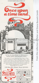
Flyer, collected 1979, Once Upon a Time Land: pony rides, painting and sculpture, gnomezville, aquarium and reptile house (from collection of Peter and Diana Bassett-Smith).main road, eltham, businesses, once upon a time land -
 Ballarat Clarendon College
Book, The story of the family called White 1852-1982, c1982
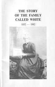
The White were one of the earliest pioneer families to select land in the Ballarat district. Albert Telfer White attended Ballarat College 1912 - 1913 and was killed during WW1. Soft cover, stapled binding, black and white illustration to coveralbert telfer white, world war one, 1914, ballarat college -
 Greensborough Historical Society
Newspaper Clipping, Diamond Valley Leader, Highway 'robbery', 07/03/2018
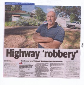
A couple believe they're being robbed by VicRoads after they were offered a measly $200,000 for their house and half an acre (0.202ha) of land in Plenty for the Yan Yean Road duplication.News article 1 page, black text and colour image .vicroads, yan yean road, publicly acquired, joe miraglia -
 Greensborough Historical Society
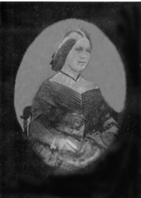
Photograph - Digital image, Anna Flintoff 1855, 1855c
Photograph of a portrait of Anna Flintoff dated circa 1855. The Flintoff family came to Greensborough circa 1841. They owned, farmed and leased land north of the present Civic Drive.Digital copy of black and white photograph.flintoff family, anna flintoff -
 Greensborough Historical Society
Photograph - Digital image, Frederick Nevins Flintoff, 1850c
Photograph of Frederick Nevins Flintoff. The Flintoff family came to Greensborough circa 1841. They owned, farmed and leased land north of the present Civic Drive. A pioneer Greensborough family. A pioneer Greensborough family. Digital copy of black and white studio photograph.frederick nevins flintoff, flintoff family -
 Greensborough Historical Society
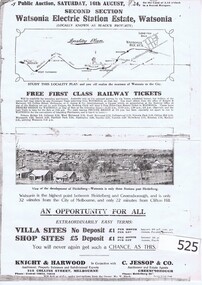
Advertising Leaflet, Knight & Harwood, Electric Station Estate, Second Section, Watsonia, 16/08/1924
Photocopy of auction leaflet for sale of second section of land north of Watsonia Railway Station, Saturday 16th August 1924. Auctioneer Knight & Harwood in conjunction with C. Jessop.Photocopy of auction leaflet 1 p.watsonia, watsonia electric station estate -
 Greensborough Historical Society
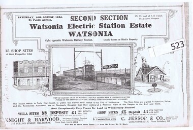
Advertising Leaflet, Knight & Harwood, Electric Station Estate, Second Section, Watsonia, 16/08/1924
Auction leaflet (copy) for sale of second section of land north of Watsonia Railway Station, Saturday 16th August 1924. Auctioneer Knight & Harwood in conjunction with C. Jessop.Photocopy of auction leaflet 1 p.watsonia railway station estate, watsonia -
 Eltham District Historical Society Inc
Photograph, Public toilets, Were Street, Montmorency, c.1990
Photographs of public land in Were Street, Montmorency with public toilets. Before the the erection of the wind mill. Brick paved footpath, angle parking and two public phone boxes.6 colour photographs (2 sets)montmorency, public tiolets, were street, parks, public toilets, shopping centres -
 Blacksmith's Cottage and Forge
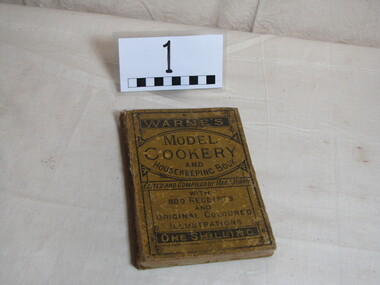
Cookery Book, Jewry-Mary, "Warne's Model Cookery & Housekeeping Book", Mid 20th. century
This cookery book belonged to Gwen Moores' family. They were a farming family whose land included The Masons Lane Recreation Reserve. the book was used between 1900 and 1930.Local historyBook, hardcover, black lettering on spineWarne's Model Cookery and Housekeeping Bookbook, domestic, kitchen, cookery, gwen moore, recipes -
 Federation University Historical Collection
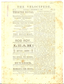
Newspaper, Untitled, The Velocipede, No 6, Saturday September 11, 1869, 11/9/1869 (exact)
A velocipede is a human-powered land vehicle with one or more wheels. Today the bicycle is the most common type of velocipede. In September 1869 Velocipede Sports were held in Ballarat. Four page printed newspaper with an articles including 'A Great Earthquake' [Lisbon 1755) and 'To My Pipe'. Includes numerous advertisements relating to Ballarat businesses.Stamped 'W.G. Chalmers"tobacco, holloway, mcgowan, freyberger, theatre royal, john stout, grocer, h anderson, watchmaker, ballarat monster tea company, e meyers, bridge street tea company, g whitty, george e jones, r benney, r wane, colonial fruit and provision company, david thomas, butcher, john buckle, tailor, w e jones, london house, j wheeler, j williams, bluchers, central tea company, pinnick and twycross, london dye works, west end venetian bliand manufactory, james allinson, saddler, wilmot oakey s self balancing bycycles, j walker, james bull, h glenny, photographer, jardine and quinn, t carrick, r lewis, j pullin, velocipede, w chalmers, chalmers, bicycle -
 Federation University Historical Collection
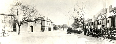
Photograph (black & white), M.B. John Brass Foundry Workers, 1927
In 1896 M.B. John started the Ballarat Brass Foundry in Armstrong Street South on land leased from the Welsh Church. See http://bih.ballarat.edu.au/index.php/Ballarat_Brass_Foundry#BackgroundTwo black and white photographs of MB John Brass Foundry Workers at their Armstrong Street factory. When joined together one large panoramic view is made, which also includes the gates of the Ballarat Gaol. Three men standing to the far right are members of the John family. john valves, mb john, tom bawden, ballarat gaol, m.b. john, morgan b. john, morgan bevan john, valves, engineering, lydiard street south, ballarat -
 City of Moorabbin Historical Society (Operating the Box Cottage Museum)
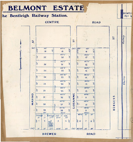
Flyer, 1922
At the end of World War One, there was a renewed interest in residential land and a number of estates opened up in the Municipality of Moorabbin. Belmont eState, Bentleigh was auction on 9 December 1922.Example of the progress of the Municipality of MoorabbinAdvertising flyer for auction of real estate sales - plan of building blocks for saleBelmont Estate, Bentleigh Railway Stationmavho street, loranne street, brewer road, bentleigh, auction, bentleigh railway station, real estate -
 Tatura Irrigation & Wartime Camps Museum
Photograph - copy, D. Clark, Tatura Cricket Team 1951-52, 1989 copy
Copy of photograph of Tatura Cricket team 1951.52. Names on back. Taken at Dhurringile, next to Dhurringile Mansion. Land donated by Jack Lowry for Cricket Oval. Original 260.1.Black and white copy of photograph of Tatura Cricket Team.on back: Tatura Cricket Team. names of team -
 Hume City Civic Collection
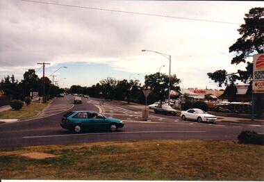
Photograph, Early 1990's
Sunbury Shopping Square now occupies the railway land which was once the football ground, scout hall, boys club, fire station and tennis courts for Sunbury residents.A coloured photograph taken at the T intersection of Macedon and Evans Streets. The Sunbury Shoping Square and car park is on the RHS of the photograph. There is a blue car on the intersection and 3 white cars are approaching the intersection from Evans Street.shopping centres, sunbury shopping square, coles supermarket, liquourland, evans street, macedon street, george evans collection -
Whitehorse Historical Society Inc.
Document, 10 Gordon Crescent, Blackburn, June 2024
The early history of Gordon Crescent, Blackburn5 pages A4non-fictionThe early history of Gordon Crescent, Blackburngordon crescent blackburn no 10, freehold investment and banking company of australia ltd, clarke arthur e. -
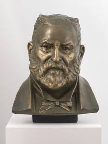 Bayside Gallery - Bayside City Council Art & Heritage Collection
Sculpture, Margaret Baskerville, Sir Thomas Bent, c. 1911
This work is a plaster maquette of a large bronze statue of politician and land speculator Sir Thomas Bent by Margaret Baskerville that is located on the corner of Bay Street and Nepean Highway, Brighton.Margaret Baskerville, Sir Thomas Bent c.1911, patinated plaster, 55 x 49 x 49 cm. Bayside City Council Art and Heritage Collection. Donated by Charles Douglas Richardson, 1931.patinated plaster thomas bent, politician, mayor, premier, bust, sculpture, margaret baskerville, land speculator, speaker, local government, councillor, member of lower house, portrait -
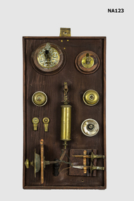 Whitehorse Historical Society Inc.
Equipment - Switches, 1900s
Fittings out of the Mitcham Station Master's house, the last block of land on the east side of Station Street, now a car park. Railway Department house number 1273 brass and ceramic light switches. 2 brass picture hooks. 1 brass and lead counterweight for lamp. 2 gas jets on wooden base. 1 door bell pull. 2 brass curtain holders. All on wooden base.metalcraft, brassware -
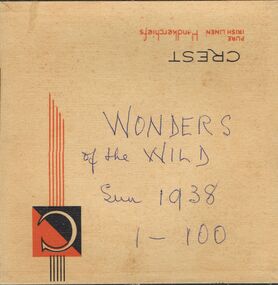 Bendigo Historical Society Inc.
Newspaper - LYDIA CHANCELLOR COLLECTION: WONDERS OF THE WILD
A handkerchief box containing 'The Sun-News Pictorial,' cuttings on 'The Wonders of the Wild.' These clips contain photos of Insects, flora, birds, fish, lizards, snakes, trees, marine animals. In serial form 1-100. Dated 1938.Wonders of the Wild. Sun 1938. 1-100place, land, wildlife, lydia chancellor, collection, wildllife, australian flora, australian fauna, plants, animals, australian plants, australian animals, australian wildlife, marine life, australian marine life, australia, sciences -
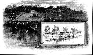 Glenelg Shire Council Cultural Collection
Artwork, other - Engraving / Illustration, n.d
Illustration. Depiction of Steven Henty's homestead, overlooking Portland Bay (view from sea, looking towards land). The dwelling is on the top of a hill with smoke coming out of the chimney and a group of people in front. Birds in flight in the foreground. There is a smaller bordered illustration on the bottom right-hand corner featuring a number of small dwellings near water, two people on a boat and a number of people on the foreshore. Image has been cut from a book, text on reverse of the image.STEPHEN HENTY'S HOMESTEAD Signature in left hand side of main image and signature of the right-hand side of the border of the smaller image. Both are illegible.first european settlers, henty, stephen henty -
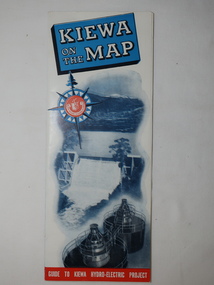 Kiewa Valley Historical Society
Map - Kiewa on the Map, Guide to Kiewa Hydro-Electric Project
Published by the SECV in 1950. They controlled the roads from Mt Beauty to the Bogong High Plains and all other roads within the Kiewa works area. The roads are not open to general tourist traffic. Conducted tours of the Kiewa area are operated by Eastern Road Lines Pty. Ltd., AlburyThe SECV constructed the KHES and controlled all roads within the Kiewa works area.Large colored map folded in half and then in 3. Front third is mostly blue and white with titles.. When opened the cover has black and white photos beside it with print and 'Please Note'. Also in the other half, a 'Road Map to Kiewa' showing the south eastern side of Australia, mostly yellow (the land) and blue (the sea). Inside the map is a close up map of "Ground Plan of Kiewa Hydro Electric Project' with a 'Key Map Showing Distances'.map of kiewa 1950, khes map -
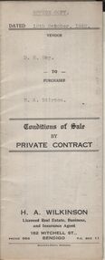 Bendigo Historical Society Inc.
Document - H.A. & S.R. WILKINSON COLLECTION: CONTRACT OF SALE
Conditions of sale by private contract dated 19th October, 1942 between D.R. Hay (seller) and H.A. Stirton (buyer) for land situate corner Creek and Hamann Streets, Bendigo, having a frontage of 85 links to Hamann Street by a depth of 134 links to Creek Street and adjoining allotments 6 and 4, and described in right to occupy residence area title No. 5429, together with 4-roomed weatherboard dwelling and all sundry. Price 270 pounds.organization, business, h.a. & s.r wilkinson real estate