Showing 20597 items
matching https://bendigotheatrecompany.org/about/
-
 St Kilda Historical Society
Photograph - Photo map, 13/01/1968
One of a series of photo-maps produced for the Department of Crown Lands and Survey (1857-1983). For correlation with a current map, and access to other historical photo maps of Victoria, see the Historic Photo-Maps Index published by the Department of Environment, Land, Water and Planning at https://services.land.vic.gov.au/DELWPmaps/historical-photomaps/Black and white aerial photograph2138 State Aerial Survey Melbourne 1968 Proj. Run 26 13.1.68 5100 ASL 203st kilda west, albert park, fawkner park, south yarra, prahran, windsor, 1968 -
 St Kilda Historical Society
Photograph - Photo map, 11/01/1968
One of a series of photo-maps produced for the Department of Crown Lands and Survey (1857-1983). For correlation with a current map, and access to other historical photo maps of Victoria, see the Historic Photo-Maps Index published by the Department of Environment, Land, Water and Planning at https://services.land.vic.gov.au/DELWPmaps/historical-photomaps/Black and white aerial photographVic 2132 State Aerial Survey Melbourne 1968 Proj. Run 27E 11.1.68 5100 ASL 69st kilda, albert park, st kilda east, st kilda beach, alma park, windsor, prahran, 1968 -
 St Kilda Historical Society
Photograph - Photo map, 11/01/1968
One of a series of photo-maps produced for the Department of Crown Lands and Survey (1857-1983). For correlation with a current map, and access to other historical photo maps of Victoria, see the Historic Photo-Maps Index published by the Department of Environment, Land, Water and Planning at https://services.land.vic.gov.au/DELWPmaps/historical-photomaps/Black and white aerial photographVic 2132 State Aerial Survey Melbourne 1968 Proj. Run 28E 11.1.68 5100 ASL 81st kilda, balaclava, st kilda east, ripponlea, elwood, elsternwick, caulfield, st kilda botanical gardens, 1968 -
 St Kilda Historical Society
Photograph - Photo map, 11/01/1968
One of a series of photo-maps produced for the Department of Crown Lands and Survey (1857-1983). For correlation with a current map, and access to other historical photo maps of Victoria, see the Historic Photo-Maps Index published by the Department of Environment, Land, Water and Planning at https://services.land.vic.gov.au/DELWPmaps/historical-photomaps/Black and white aerial photographVic 2132 State Aerial Survey Melbourne 1968 Proj. Run 29E 11.1.68 5100 ASL 194elwood, elwood beach, elwood park, elsternwick park, ripponlea, elwood canal, balaclava, st kilda, 1968 -
 St Kilda Historical Society
Photograph - Photo map, 11/01/1968
One of a series of photo-maps produced for the Department of Crown Lands and Survey (1857-1983). For correlation with a current map, and access to other historical photo maps of Victoria, see the Historic Photo-Maps Index published by the Department of Environment, Land, Water and Planning at https://services.land.vic.gov.au/DELWPmaps/historical-photomaps/Black and white aerial photographVic 2132 State Aerial Survey Melbourne 1968 Proj. Run 27E 11.1.68 5100 ASLst kilda, st kilda west, st kilda pier, catani gardens, st kilda beach, albert park, 1968 -
 St Kilda Historical Society
Photograph - Photo map, 11/01/1968
One of a series of photo-maps produced for the Department of Crown Lands and Survey (1857-1983). For correlation with a current map, and access to other historical photo maps of Victoria, see the Historic Photo-Maps Index published by the Department of Environment, Land, Water and Planning at https://services.land.vic.gov.au/DELWPmaps/historical-photomaps/Black and white aerial photographVic 2132 State Aerial Survey Melbourne 1968 Proj. Run 29E 11.1.68 5100 ASL 196elwood, elwood park, elwood canal, elwood beach, st kilda marina, mc moran reserve, point ormond, 1968 -
 St Kilda Historical Society
Photograph - Photo map, Department of Crown Lands and Survey (1857-1983), 22/01/1970
One of a series of photo-maps produced for the Department of Crown Lands and Survey (1857-1983). For correlation with a current map, and access to other historical photo maps of Victoria, see the Historic Photo-Maps Index published by the Department of Environment, Land, Water and Planning at https://services.land.vic.gov.au/DELWPmaps/historical-photomaps/Black and white aerial photographVic 2358 Department of Crown Lands and Survey Victoria,.© Melbourne 1970 Project Run 41E 22.1.70 5,100 ASL 62caulfield, caulfield north, st kilda east, armadale, 1970 -
 St Kilda Historical Society
Photograph - Photo map, 14/12/1963
One of a series of photo-maps produced for the Department of Crown Lands and Survey (1857-1983). For correlation with a current map, and access to other historical photo maps of Victoria, see the Historic Photo-Maps Index published by the Department of Environment, Land, Water and Planning at https://services.land.vic.gov.au/DELWPmaps/historical-photomaps/Black and white aerial photographVic 1807 Melbourne 1963 Project Run 17 14.12.63 Lens 205 152.70 M/M 5.150 36st kilda, st kilda botanical gardens, balaclava, st kilda east, elwood canal, ripponlea, caulfield north, elwood, caulfield, 1963 -
 St Kilda Historical Society
Photograph - Photo map, Department of Crown Lands and Survey (1857-1983), 22/01/1970
One of a series of photo-maps produced for the Department of Crown Lands and Survey (1857-1983). For correlation with a current map, and access to other historical photo maps of Victoria, see the Historic Photo-Maps Index published by the Department of Environment, Land, Water and Planning at https://services.land.vic.gov.au/DELWPmaps/historical-photomaps/Black and white aerial photographVic 2358 Department of Crown Lands and Survey Victoria,.© Melbourne 1970 Project Run 42E 22.1.70 5,100 ASL 77st kilda, st kilda east, st kilda marina, elwood, elwood canal, elsternwick park, point ormond, balaclava, mc moran reserve, ripponlea, st kilda botanical gardens, peanut farm, 1970 -
 St Kilda Historical Society
Photograph - Photo map, Department of Crown Lands and Survey, 22/01/1970
One of a series of photo-maps produced for the Department of Crown Lands and Survey (1857-1983). For correlation with a current map, and access to other historical photo maps of Victoria, see the Historic Photo-Maps Index published by the Department of Environment, Land, Water and Planning at https://services.land.vic.gov.au/DELWPmaps/historical-photomaps/Black and white aerial photographVic 2358 Department of Crown Lands and Survey Victoria,.© Melbourne 1970 Project Run 43E 22.1.70 5,100 ASL 208elwood, elwood beach, point ormond, elwood park, elwood canal, mc moran reserve, 1970 -
 St Kilda Historical Society
Photograph - Photo map, Department of Crown Lands and Survey, 22/01/1970
One of a series of photo-maps produced for the Department of Crown Lands and Survey (1857-1983). For correlation with a current map, and access to other historical photo maps of Victoria, see the Historic Photo-Maps Index published by the Department of Environment, Land, Water and Planning at https://services.land.vic.gov.au/DELWPmaps/historical-photomaps/Black and white aerial photographCONTROLLED Vic 2358 Department of Crown Lands and Survey Victoria,.© Melbourne 1970 Project Run 41E 22.1.70 5,100 ASL 66st kilda, albert park, st kilda west, catani gardens, st kilda botanical gardens, st kilda pier, st kilda beach, 1970 -
 St Kilda Historical Society
Photograph - Photo map, Department of Crown Lands and Survey, 22/01/1970
One of a series of photo-maps produced for the Department of Crown Lands and Survey (1857-1983). For correlation with a current map, and access to other historical photo maps of Victoria, see the Historic Photo-Maps Index published by the Department of Environment, Land, Water and Planning at https://services.land.vic.gov.au/DELWPmaps/historical-photomaps/Black and white aerial photographVic 2358 Department of Crown Lands and Survey Victoria,.© Melbourne 1970 Project Run 42E 22.1.70 5,100 ASL 75st kilda, st kilda beach, st kilda marina, point ormond, st kilda pier, 1970 -
 St Kilda Historical Society
Photograph - Photo map, 14/12/1963
One of a series of photo-maps produced for the Department of Crown Lands and Survey (1857-1983). For correlation with a current map, and access to other historical photo maps of Victoria, see the Historic Photo-Maps Index published by the Department of Environment, Land, Water and Planning at https://services.land.vic.gov.au/DELWPmaps/historical-photomaps/Black and white aerial photographVic 1807 Melbourne 1963 Project Run 16 14.12.1963 Lens 205 152.70 M/M 5.150 177st kilda, st kilda pier, catani gardens, middle park, albert park, st kilda west, st kilda beach, 1963 -
 St Kilda Historical Society
Photograph - Photo map, Department of Crown Lands and Survey, 22/01/1970
One of a series of photo-maps produced for the Department of Crown Lands and Survey (1857-1983). For correlation with a current map, and access to other historical photo maps of Victoria, see the Historic Photo-Maps Index published by the Department of Environment, Land, Water and Planning at https://services.land.vic.gov.au/DELWPmaps/historical-photomaps/Black and white aerial photographVic 2358 Department of Crown Lands and Survey Victoria,.© Melbourne 1970 Project Run 41E 22.1.70 5,100 ASL 64st kilda, st kilda cemetery, balaclava, st kilda east, windsor, caulfield north, alma park, 1970 -
 St Kilda Historical Society
Photograph - Photo map, Department of Crown Lands and Survey, 08/01/1970
One of a series of photo-maps produced for the Department of Crown Lands and Survey (1857-1983). For correlation with a current map, and access to other historical photo maps of Victoria, see the Historic Photo-Maps Index published by the Department of Environment, Land, Water and Planning at https://services.land.vic.gov.au/DELWPmaps/historical-photomaps/Black and white arial photographVic 2345 Department of Crown Lands and Survey Victoria,.© Melbourne 1970 Project Run 40 8.1.70 5,100 ASL 77albert park, fawkner park, south yarra, middle park, prahran, windsor, st kilda, st kilda west, 1970 -
 St Kilda Historical Society
Photograph - Photo map, 22/01/1970
One of a series of photo-maps produced for the Department of Crown Lands and Survey (1857-1983). For correlation with a current map, and access to other historical photo maps of Victoria, see the Historic Photo-Maps Index published by the Department of Environment, Land, Water and Planning at https://services.land.vic.gov.au/DELWPmaps/historical-photomaps/Black and white aerial photographVic 2358 Department of Crown Lands and Survey Victoria,.© Melbourne 1970 Project Run 43E 22.1.70 5,100 ASL 206elwood, elsternwick, elsternwick park, 1970 -
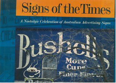 Bendigo Historical Society Inc.
Book - Signs of the Times
Well-known as an artist, author, historian, illustrator and publisher, Geoff Hocking grew up in the goldfields city of Bendigo and lives today in Castlemaine. His work reflects a passion for the heritage of the goldfields region. https://artsopen.com.au/wp-content/uploads/2021/11/geoff-hocking-CV-2019.pdf Full title. "Signs of the Times. A nostalgic Celebration of Australian Advertising Signs. Written by Geoff Hocking. Published by Five Mile Press in 2007. Hard cover book with dust jacket. Blue and gold colouring. Front cover has a picture of a Bushells sign on a brick wall with a peters Ice cream sign in the corner. Back cover has eight smaller advertising signs. 228 pp. containing advertising signs from across Australia with historical notes and descriptions.signs, geoff hocking, photographs, advertising -
 Greensborough Historical Society
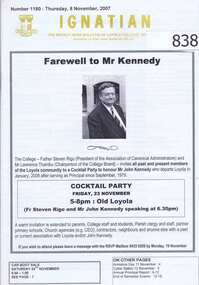
Newsletter, Ignatian: the weekly news bulletin of Loyola College. Number 1180, 8th November 2007, 08/11/2007
This edition of the Loyola newsletter "Ignatian" deals with information about the college. The front page story is about the retiring Principal of Loyola college John Kennedy.Mr Kennedy was Principal of Loyola from 1979 to 2008.20 pages, typed and photocopied.loyola college, john kennedy, ignatian -
 Ballarat Heritage Services
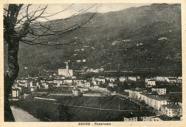
Photograph - Photograph - Black and White, Zogno, Lombardy, Italy
Zogno is a comune (municipality) in the Province of Bergamo, Lombardy, Italy. It is located about 50 kilometres northeast of Milan and about 11 kilometres north of Bergamo.Black and white photographic postcard of Zogno in Lombardy, Italy. zogno, italy, gervasoni -
 Glen Eira Historical Society
Document - Hengar, Glen Eira Road, 356, Elsternwick
One page of undated, unattributed, handwritten notes giving information about the custom of building a dower house, the history of Hengar’s occupancy and brief information about some of Hengar’s residents. The document also provides a description of a photograph of Hengar and information about social customs relating to the wearing of hats.hengar, happy days kindergarten, beemery park, glen eira road, langdon laura, langdon j k, langdon e ll, langdon emily amy, penleigh, sadler emily amy, rosecraddock, moxham mrs, parsons mrs, holmes mrs -
 Ballarat Tramway Museum
Document - Report, State Electricity Commission of Victoria (SECV), "Bendigo Tramways", 10/10/1947
Gives historical notes about the Bendigo trams, battery trams, steam, and then electric trams. Has a note about the early tracks and upgrading by the SEC, track relocation, overhead rehabilitation and rolling stock. Gives notes about acquisition of the trams ex MMTB, the Birneys and max traction trams.Yields a information about the early history of the trams in Bendigo. Gives information about the track, overhead and tramcars - 1947.Two page, typed notes on foolscap paper, titled "Bendigo Tramways", dated 10-10-1947, with initials "TT/DAS" in the top left hand corner. In top right hand corner in black ink "BTPS 406"trams, tramways, bendigo, sec, mmtb, track, overhead, rolling stock -
Clunes Museum
Leisure object - IRON QUOITS
IRON QUOITS WEIGH ABOUT 9LBS. OR 4.1KG. TWO IRON PEGS ABOUT 2'.6" LONG AND 1" IN DIAMETER. TWO CLAY PITS WERE DUG ABOUT 30' APART, 3' LONG AND ABOUT 2' 6" WIDE. THESE PITS WERE FILLED WITH RED CLAY AND THE IRON PEGS PLACED UPRIGHT IN THE CENTRE. EACH PLAYER TAKING A TURN AT THROWING THE QUOIT TO FINISH CLOSEST TO THE PIN. SCORING WAS COUNTED OVER SEVERAL ENDS..1 BOOKLET WITH SET OF RULES. .2 HEAVY METAL CIRCULAR DISCS WITH CENTRE REMOVED TO FORM A RING TO BE THROWN IN PLAY TO ENCIRCLE A PEG OR FINISH AS NEAR TO THE PEG AS POSSIBLE. .3 STICK OR PEG TO BE PLACED IN THE GROUND local history, recreation, sport - quoits -
Vision Australia
Audio - Sound recording, Vision Australia, Around Vision Australia: Episode 31
Covering issues and news about Vision Australia and the opportunities it provides for clients, volunteers and staff. Host: Stephen Jolley with guest interviews by Valerie Thomas. Stephen Jolley speaks with Julie Scott from the Adapt Centre about equipment solutions. Robyn talks with Siobhan Dennis about new titles from the Library. Valerie Thomas’s guest is Michael Simpson and Robyn chats with Kate Gniel about news from Marketing Department1 digital sound file in WAV formatradio shows, vision australia, valerie thomas, kate gniel, robyn mckenzie, julie scott, siobhan dennis, michael simpson -
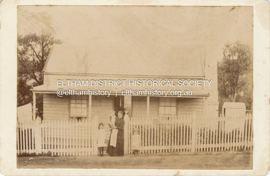 Eltham District Historical Society Inc
Photograph, Believed to be Sarah Aldous (nee Shillinglaw) with children, Florence, Elizabeth and Percival, c.1888
House at Diamond Creek Aldous Percival John : SERN DEPOT 160 : POB Melbourne VIC : POE Melbourne VIC : NOK F Aldous Charles https://recordsearch.naa.gov.au/SearchNRetrieve/Interface/DetailsReports/ItemDetail.aspx?Barcode=3024310&isAv=N Percival John Aldous was killed in action 19 Aug 1915 at Gallipoli CABINET 1866-1905 The Cabinet photo was introduced in 1866 in answer to a demand for a larger format photograph which could be mounted for a cabinet or on the wall. They were 4.5 inches by 6.5 inches (11.5 x 16.5 cm), more than twice the size of the cdv. They cost about twice as much as a cdv but eventually displaced them. They were not extensively produced until 1880 and had ceased by 1905. Coloured mounts, especially maroon or green, indicate a date between 1880 and 1890. - Frost, Lenore; Dating Family Photos 1850-1920; Valiant Press Pty. Ltd., Berwick, Victoria 1991marg ball collection, shillinglaw family photo album 2, 1888, cabinet photo, elizabeth annie aldous, florence may aldous, house, percival john aldous, sarah aldous (nee shillinglaw 1854-1925) -
![View of portion of the City of Sandhurst, as seen from the hill, Camp Reserve / [by] Nicholas Caire, circa 1876](/media/collectors/550653872162f11fb04854aa/items/57774295d0cdd10a5c0eb588/item-media/57774325d0cdd10a5c0f0b71/item-fit-380x285.jpg) Kew Historical Society Inc
Kew Historical Society IncPhotograph, Anglo-Australasian Photographic Company, View of portion of the City of Sandhurst, as seen from the hill, Camp Reserve, c. 1876
Nicholas Caire was born on Guernsey in the Channel Islands in 1837. He arrived in Adelaide with his parents in about 1860. In 1867, following photographic journeys in Gippsland, he opened a studio in Adelaide. From 1870 to 1876 he lived and worked in Talbot in Central Victoria. In 1876 he purchased T. F. Chuck's studios in the Royal Arcade Melbourne. In 1885, following the introduction of dry plate photography, he began a series of landscape series, which were commercially successful. As a photographer, he travelled extensively through Victoria, photographing places few of his contemporaries had previously seen. He died in 1918. Reference: Jack Cato, 'Caire, Nicholas John (1837–1918)', Australian Dictionary of Biography, National Centre of Biography, Australian National University, http://adb.anu.edu.au/biography/caire-nicholas-john-3139/text3683, published first in hardcopy 1969, accessed online 1 July 2016.An original, rare photograph from the series 'Views of Victoria: General Series' by the photographer, Nicholas Caire (1837-1918). The series of 60 photographs that comprise the series was issued c. 1876 and reinforced a neo-Romantic view of the Australian landscape to which a growing nationalist movement would respond. Nicholas Caire was active as a photographer in Australia from 1858 until his death in 1918. His vision of the Australian bush and pioneer life had a counterpart in the works of Henry Lawson and other nationalist poets, authors and painters.Albumen Silver Photograph, mounted on Board.printed in ink on support l.c.: VIEW OF PORTION OF THE CITY OF SANDHURST, AS SEEN FROM THE HILL, CAMP RESERVE / COPYRIGHT REGISTERED. printed in ink on support reverse c.: VIEWS OF VICTORIA. / (GENERAL SERIES.) / No. 4. / VIEW OF PORTION OF THE CITY OF SANDHURST AS SEEN FROM THE HILL, CAMP RESERVE. / The Camp Reserve is the principal public promenade in this City. The Rotunda in the foreground, formerly used / by the local bands on festive occasions, is now regarded as a relic of the past. To the right of the picture is shown the / City of Sandhurst claim, supposed to be on the Hustler's line of reef. St. Paul's Church tower may be seen in the / distance. To the left of the picture Williamstown-street branches out from Pall Mall. On one side of the street is the / far-famed Shamrock Hotel; on the other stands the Bank of Australasia, with St. James's Hall immediately behind it. printed in ink on support reverse l.c.l.: J.W. FORBES, Agent, printed in ink on support reverse l.c.: ANGLO-AUSTRALASIAN PHOTOGRAPHIC COMPANY, MELBOURNE. printed in ink on support reverse l.c.r.: 10 Temple Court, Collins Street West.nicholas caire (1837-1918), landscape photography -
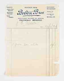 City of Greater Bendigo - Civic Collection
Financial record - Invoice, Bolton Brothers Printers, Bolton Brothers, 1920
Benjamin Bolton and his two eldest sons, William and Arthur, began a printing business known as Bolton & Sons on March 25, 1885. The location of the original printing business was in High Street, Bendigo but later moved to Williamson Street where the business underwent a name change to Bolton Bros and expanded into manufacturing paper bags and other stationery lines. In 1902, Bolton Bros moved to 43 Mitchell Street which housed the retail stationery department and the main office, while the printing factory was on the second and third floors. Next door at 47 Mitchell Street the wholesale division and machine service department operated. William and Arthur Bolton and their sons travelled throughout central and northern Victoria selling their own products and representing other companies. Bolton Bros continue to trade today with fifth generation family ownership continuing the tradition. (Fn https://www.boltonbros.com.au/about-us)Printed and handwritten paper invoice from Bolton Bros. to JH Abbott dated 14/1/20 for nibs.mayor bolton, mayor abbott, city of greater bendigo commerce, making a nation exhibition, bolton brothers printers, mayoress bolton -
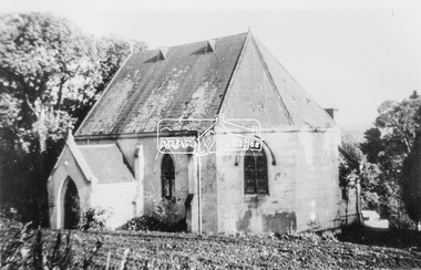 Eltham District Historical Society Inc
Photograph, Catholic Church, Main Street, Diamond Creek, c.1963
Photo sourced from N. Stone reproduced on p178 of The Diamond Valley Story by Dianne H. Edwards, Shire of Diamond Valley 1979. "The first Catholic Church, Main Street, Diamond Creek. Opened in 1874, it has been replaced by the new Sacred Heart Church next to the railway station. Additions built during the 1970s have transformed it into an abbey-like restaurant. This photo shows the building before the alterations." Similar image by John T. Collins held by State Library of Victoria dated 1963 http://search.slv.vic.gov.au/permalink/f/1o9hq1f/SLV_VOYAGER1672213 Former Catholic church with significant development became the Abbey Reception Centre and now Tobin Brothers 49-55 Main Street See images https://tobinbrothers.com.au/diamond-creek/Black and white copy of photo printed on glossy photographic paper 30.5 x 40.5 cm (12 x 16 inch); image size approx. 18.5 x 28 cmabbey reception centre, catholic church, diamond creek, diamond valley story, tobin brothers, main street -
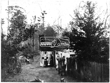 Eltham District Historical Society Inc
Photograph, H.J. Trowbridge, First kitchen at the first Post Office, Kinglake, c.1905, 1905
Reproduced 'Pioneers & Painters' p43 Source: Mrs. McMinn, Kinglake The photo is embossed in the lower left hand "H.J. Trowbridge," a photographer operating from at least 1895 and a photo stock dealer, developer and printer operating from Camera House in Collins St, Melbourne importing the finest English photographic equipment, paper, etc from 1905 through 1910 when he retired (Photo-focus. (1910, September 1). Punch (Melbourne, Vic. : 1900 - 1918; 1925), p. 3. Retrieved from http://nla.gov.au/nla.news-article175606285). He produced a 200 page catalogue in 1906 (H. J. TROWBRIDGE'S CATALOGUE. (1906, November 22). Punch (Melbourne, Vic. : 1900 - 1918; 1925), p. 3. Retrieved from http://nla.gov.au/nla.news-article175379934)This photo forms part of a collection of photographs gathered by the Shire of Eltham for their centenary project book,"Pioneers and Painters: 100 years of the Shire of Eltham" by Alan Marshall (1971). The collection of over 500 images is held in partnership between Eltham District Historical Society and Yarra Plenty Regional Library (Eltham Library) and is now formally known as 'The Shire of Eltham Pioneers Photograph Collection.' It is significant in being the first community sourced collection representing the places and people of the Shire's first one hundred years.Digital image of 4 x 5 inch B&W Negative Also 19 x 25 cm printPhotographers name H.J. Trowbridge Lwr LHsepp, shire of eltham pioneers photograph collection, kinglake, post office -
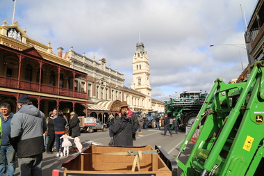
 Victorian Farmers Federation
Photograph - Digital Photograph, Stop Ausnet Rally Ballarat - Katherine Myers, Scott Young, Charles Everist, 15 July 2022
VFF is seeking an appropriate framework to ensure farmers do not bear the cost of infrastructure on their farms. Overhead powerlines are proposed through the rich volcanic soils around Ballarat. This land supports 1200 jobs in processing in Ballarat. The towers would impact on the ability to irrigate crops, to use tractors around them, on biosecurity and on ability to use emergency equipment near them. VFF wants assurances that the managing entry to farm policy position will be adhered to and that a statewide strategic plan for renewable energy is prepared. https://www.vff.org.au/wp-content/uploads/2021/09/PS210901LG-Managing-Entry-to-Farms-adopted.pdf https://www.vff.org.au/wp-content/uploads/2021/09/VFF-Renewable-Energy-and-Energy-Efficiency-Policy-Statement-Meeting-172-June-2021.pdfadvocacy, renewable energy, farmers, protest, rally, managing entry to farm, victorian farmers federation, ballarat -
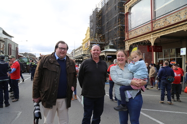
 Victorian Farmers Federation
Photograph - Digital Photograph, Stop Ausnet Rally Ballarat - post event scenes, 15 July 2022
VFF is seeking an appropriate framework to ensure farmers do not bear the cost of infrastructure on their farms. Overhead powerlines are proposed through the rich volcanic soils around Ballarat. This land supports 1200 jobs in processing in Ballarat. The towers would impact on the ability to irrigate crops, to use tractors around them, on biosecurity and on ability to use emergency equipment near them. VFF wants assurances that the managing entry to farm policy position will be adhered to and that a statewide strategic plan for renewable energy is prepared. https://www.vff.org.au/wp-content/uploads/2021/09/PS210901LG-Managing-Entry-to-Farms-adopted.pdf https://www.vff.org.au/wp-content/uploads/2021/09/VFF-Renewable-Energy-and-Energy-Efficiency-Policy-Statement-Meeting-172-June-2021.pdfadvocacy, renewable energy, farmers, protest, rally, managing entry to farm, victorian farmers federation, ballarat