Showing 97062 items
matching school-of-mines-and-industries
-
 Ringwood and District Historical Society
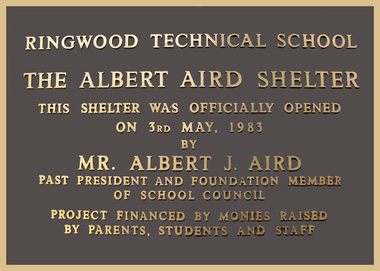
Plaque, Ringwood Technical School plaque commemorating Albert Aird Shelter - 1983, 1983
Installed 3-May-1983. The school no longer exists.Metal Plaque 'Ringwood Technical School/ The Albert Aird Shelter' embossed. 'Ringwood Technical School/ The Albert Aird Shelter/ This Shelter was officially opened on 3rd May 1983/ by/ Mr Albert J. Aird/ past president and foundation member of school council/ project funded by monies raised/ by parents students and staff -
 Greensborough Historical Society
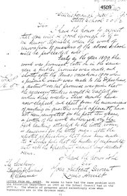
Letter (copy), Greensborough Primary School et al, Mr Amiet to Education Department Greensborough State School Gr2062, 02/05/1900
Louis Amiet was Head Teacher of Greensborough State School from 1895 to 1917. In this letter, Mr Amiet reminds the Secretary of the Education Department of 'promises' made to renovate areas of the school, which have not been done. Handwritten letter copied on white paper, black text greensborough primary school, greensborough state school -
 Melton City Libraries
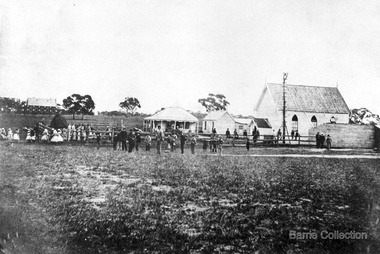
Photograph, Denominational Church and School, Unknown
... Denominational Church and School ...Presbyterian Church Melton Background: A Combined Denominational Church and School was established in Melton by Protestants from the Presbyterian, Episcopalian, Wesleyan and Baptists denominations. A wooden church was built on the flat area east of the Toolam Toolern Creek. A photo of this church shows the buildings with small houses nearby. In the background the bluestone Presbyterian Church built in 1867 can be seen to the north on Yuille and Sherwin street. The flat area beside the road to Ballarat was subject to flooding and the site was eventually abandoned for a settlement. By the latter part of the 1860s the Church of England and Wesleyan bluestone churches were also being erected in the centre of the township of Melton. The commercial centre developed in High Street from Smith to Palmerston Street. Township of Melton Crown Grants Issued Under Common Law refers to the site of the Combined Denominational Church and School on the east side of Sherwin Street on the corner of Pyke Street. Section 4 Allotments 1 and 10 situated on the corner of Pyke, Bryan and Sherwin Street. The early map has the name of Thomas Cridge on this site. The area known Common (flat) remained open level ground with some cottages and buildings and a milk cooler in the 1930s, Granny Watts house “Lynch Cottage was moved in 1964. Sherwin Street was used until the 1960s with the open area being the used for playing golf. Alterations to the flat occurred when the golf course added to the height and removed the Sherwin Street access. The greens were developed and the height of ground altered the vista across Common. The first Presbyterian Minister in the district was the Reverend Alexander McNicol an advanced student and an experienced missionary from Glasgow, arriving in Melbourne in 1850. He was ordained on the 8th of June and was called to the Bacchus Marsh and Mount Macedon district. On the 1st of May 1851 he was called to Geelong and returned to Bacchus Marsh on February 1856 remaining until July 1859. Group of people in front of the church and school.churches, local identities, education -
 Federation University Historical Collection
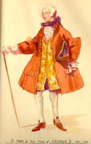
Book, Historic Ornament Parts I and II. Ballarat Technical Art School Art History Books, 1931, 1931
... Historic Ornament Parts I and II. Ballarat Technical Art ...Edith CURNOW (1913–2003) Ballarat | Australia Edith Gertrude Curnow undertook Industrial Art teacher training at the Ballarat Technical Art School, with a five-year Senior Technical Scholarship, between 1926 and 1931. She taught for a time before marrying compositor James Lawn in 1937. She reportedly continued to teach at the Ballarat Technical Art School as Edith Lawn. She retired in 1972 at which time she was the Lecturer in Charge of Craft Edith Lawn was a member of inaugural Ballarat School of Mines Old Girls Association, and served as first Press Correspondent. Her daughter, Valda Lawn (later D'Angri) also attended and taught at the School. One of the subjects Curnow studied was Historic Ornament. This subject spanned time and space to inform and inspire designers. Students studied the influences of history, geography, culture and climate on ornamental aesthetics, including the tools, materials and methods applied to decorative objects, interior design and architecture.Two books containing student notes and drawing relating to courses at the Ballarat techncial Art School in 1931. The work was undertaken by Edith Curnow. .1) - Foolscap red covered book on Historic Ornament. Includes History of Ornament, Egyptian Ornament, Assyrian Ornament; Greek Ornament, Roman Ornament, Pompeian Ornament, Byzantine, Romanesque Ornament, Norman, Decorated Gothic, Perpendicular Gothic, Renaissance. .2) Green quarto book on Historic Ornament Part 2: Costume. The work includes Egyptian Costume, Greek Costume, Roman Costume, Richard I, Crusades, Edward III, Charles I, Charles II, George II.ballarat school of mines, ballarat technical art school, art history, edith lawn, edith curnow, val lawn, val d'angri, curnow, lawn, ornament, costume., ballarat technical art school library, artists workbook, journal, historic ornament, university women, ballarat school of mines old girls association -
 Victorian Aboriginal Corporation for Languages
CD-ROM, NSW Aboriginal Languages Research and Resource Centre, The Aboriginal Languages of NSW: an introduction for schools and communities, 2007
... The Aboriginal Languages of NSW: an introduction for...NSW Aboriginal Languages Research and Resource Centre ...Contents: What is this CD rom for? Why learn an Aboriginal language? : benefits of learning a language; specific benefits for Aboriginal students; why offer an Aboriginal language in NSW schools?; First steps to start a school-based Aboriginal language program Information about NSW Aboriginal languages: Aboriginal language revival in NSW : the same but different; sounds and writing system; some grammatical features; Map of Aboriginal languages of NSW; List of languages on this CD.CD-ROMlanguage maintenance, language and education -
 Greensborough Historical Society
Handbook, Watsonia High School, Watsonia High School Staff Information Paper 1977, 1977_
Information for staff at Watsonia High School 1977.Typed booklet, stapled in top left corner. Yellow cover. -
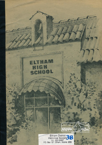 Eltham District Historical Society Inc
Book, Eltham High School, A History, 1926-1978, 1978
History of Eltham High School 1926 to 197857 p. : ill., portraits, pbk ; 30 cm. 2 copies[includes loose newspaper clippings]eltham high school -
Stawell Historical Society Inc
Book, Stawell Technical School, MAG Stawell Technical School Magazine 1985, 1985
Stawell Technical School End of Year MagazineA4 Magazine in Black & Whiteeducation -
Federation University Art Collection
Drawing - Artwork - Drawing, Lamb, Evelyn, Ballarat Technical Art School Folio by Evelyn Lamb, 1900
Evelyn Lamb was a student at the Ballarat Technical Art School, a division of the Ballarat School of Mines. Ten drawings by Evelyn Lamb of the Ballarat Technical Art School. .1) triangle and circle .2) vase .3) Jonquils .4) Drawing from Plaster (with technical art school number) .5) Drawing from Plaster .6) Drawing from Plaster .7) Drawing from Plaster .8) Drawing from Urn .10) plantevelyn lamb, drawing, ballarat technical art school, drawing from plaster, folio, alumni -
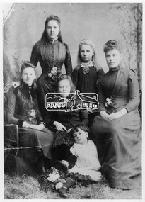 Eltham District Historical Society Inc
Photograph, Frances Ellen Hurst (tall standing rear), with other girls and mistress of small ladies school, Preston, 1890
... and mistress of small ladies school, Preston ...Frances Ellen Hurst, standing at rear with other girls and the Mistress of a small ladies school in Preston which she attended. Frances was the daughter of Francis and Catherine Hurst of Hurstbridge. This photo forms part of a collection of photographs gathered by the Shire of Eltham for their centenary project book, "Pioneers and Painters: 100 years of the Shire of Eltham" by Alan Marshall (1971). The collection of over 500 images is held in partnership between Eltham District Historical Society and Yarra Plenty Regional Library (Eltham Library) and is now formally known as 'The Shire of Eltham Pioneers Photograph Collection.' It is significant in being the first community sourced collection representing the places and people of the Shire's first one hundred years.Digital imagesepp, shire of eltham pioneers photograph collection, hurstbridge, frances ellen hurst, group, preston -
Stawell Historical Society Inc
Map, Stawell Gold Mines Pty Ltd, Plan of Magdala Mine. May 1994, May 1994
... Plan of Magdala Mine. May 1994...Stawell Gold Mines Pty Ltd ...Moonlight Junction, Big Newington Co. Pleasants Creek and Newington, Prince Patrick, North Cross Extended, Prince Alfred, Robson and Party, North Magdala, Galatea and Pioneer Co., Duke Magdal, Moonlight, Moonlight Extended, Sliding Shaft, Extended Cross, Crown Cross United, Great Northern, Sloanes and Scotchmans, Marinees, North Waterloo, Scothmans United, Waterloo, Scotchmans Iron Duke and Bulcher, Perthen Shire, Prince of Wales, Roberts, Shafts of Rose of Denmark, Emerald Isle Shafts, O'Donnels, Darlington,, Albion, Federal, Ulster, Goldenpoint and Wexford.AO Printed Map In Colour. Showing Underground Workings and PortalScale 1 : 2500 -
Stawell Historical Society Inc
Map, Stawell Gold Mines, Plan View of Township Area Showing Known Old Workings. 2003, 13/06/2003
... Plan View of Township Area Showing Known Old Workings. 2003...Stawell Gold Mines ...Two AO Maps that Overlap Showing Old workings on Map of Town North of Patrick StreetScale 1 : 5000 -
Ringwood and District Historical Society
Document - Visitors Book, Ringwood Primary School, Ringwood Primary School - Centenary Visitors' Book - 1989, 1989
Red covered binder with red plastic spine, A4 pages - 4 blank and 23 used to record names, addresses and years of attendance of former pupils at the Ringwood Primary School Centenary in 1989. +Additional Keywords: Osborne, Geoff (Principal) -
 Kew Historical Society Inc
Plan, Melbourne & Metropolitan Board of Works : Borough of Kew : Detail Plan No.1588, 1904
... Melbourne & Metropolitan Board of Works : Borough of Kew...City of Kew...Melbourne and Metropolitan Board of Works ...The Melbourne and Metropolitan Board of Works (MMBW) plans were produced from the 1890s to the 1950s. They were crucial to the design and development of Melbourne's sewerage and drainage system. The plans, at a scale of 40 feet to 1 inch (1:480), provide a detailed historical record of Melbourne streetscapes and environmental features. Each plan covers one or two street blocks (roughly six streets), showing details of buildings, including garden layouts and ownership boundaries, and features such as laneways, drains, bridges, parks, municipal boundaries and other prominent landmarks as they existed at the time each plan was produced. (Source: State Library of Victoria)This plan forms part of a large group of MMBW plans and maps that was donated to the Society by the Mr Poulter, City Engineer of the City of Kew in 1989. Within this collection, thirty-five hand-coloured plans, backed with linen, are of statewide significance as they include annotations that provide details of construction materials used in buildings in the first decade of the 20th century as well as additional information about land ownership and usage. The copies in the Public Record Office Victoria and the State Library of Victoria are monochrome versions which do not denote building materials so that the maps in this collection are invaluable and unique tools for researchers and heritage consultants. A number of the plans are not held in the collection of the State Library of Victoria so they have the additional attribute of rarity.Original survey plan, issued by the MMBW to a contractor with responsibility for constructing sewers in the area identified on the plan within the Borough of Kew. The plan was at some stage hand-coloured, possibly by the contractor, but more likely by officers working in the Engineering Department of the Borough and later Town, then City of Kew. The hand-coloured sections of buildings on the plan were used to denote masonry or brick constructions (pink), weatherboard constructions (yellow), and public buildings (grey). This plan shows the original configuration of the Kew Post Office, Court House and Police Station, which had opened in 1888. This configuration was to essentially remain until the purchase of the Court House and Police Station by the City of Boroondara in 2007 and its subsequent renovation. Interestingly, the MMBW surveyors incorrectly labelled parts of the complex. In the triangle in front of the Post Office, before the erection of the Kew Cenotaph in 1925, was located a lawn and the Queen Victoria Jubilee Fountain. While many of the shops on the south side of High street had been constructed by 1903 a number of sites were still used as vegetable gardens. Further along High Street, on the corner of Charles Street, the Salvation Army Barracks can be seen on the plan. These Barracks predate the later Citadel and ‘Young People’s Hall’ that were opened in 1919. At 22 Charles Street can be seen the house of James Venn Morgan. Hailed as the ‘father of Kew’, Morgan arrived in Melbourne in 1840. He was first engaged as a bookmaker, but a fortunate venture on the goldfields enabled him to purchase land in Kew. He conducted a market garden and dairy in Kew for many years.melbourne and metropolitan board of works, detail plans, maps - borough of kew, mmbw 1588, cartography -
 Kew Historical Society Inc
Plan, Melbourne & Metropolitan Board of Works : Borough of Kew : Detail Plan No.1590, 1905
... Melbourne & Metropolitan Board of Works : Borough of Kew...City of Kew...Melbourne and Metropolitan Board of Works ...The Melbourne and Metropolitan Board of Works (MMBW) plans were produced from the 1890s to the 1950s. They were crucial to the design and development of Melbourne's sewerage and drainage system. The plans, at a scale of 40 feet to 1 inch (1:480), provide a detailed historical record of Melbourne streetscapes and environmental features. Each plan covers one or two street blocks (roughly six streets), showing details of buildings, including garden layouts and ownership boundaries, and features such as laneways, drains, bridges, parks, municipal boundaries and other prominent landmarks as they existed at the time each plan was produced. (Source: State Library of Victoria)This plan forms part of a large group of MMBW plans and maps that was donated to the Society by the Mr Poulter, City Engineer of the City of Kew in 1989. Within this collection, thirty-five hand-coloured plans, backed with linen, are of statewide significance as they include annotations that provide details of construction materials used in buildings in the first decade of the 20th century as well as additional information about land ownership and usage. The copies in the Public Record Office Victoria and the State Library of Victoria are monochrome versions which do not denote building materials so that the maps in this collection are invaluable and unique tools for researchers and heritage consultants. A number of the plans are not held in the collection of the State Library of Victoria so they have the additional attribute of rarity.Original survey plan, issued by the MMBW to a contractor with responsibility for constructing sewers in the area identified on the plan within the Borough of Kew. The plan was at some stage hand-coloured, possibly by the contractor, but more likely by officers working in the Engineering Department of the Borough and later Town, then City of Kew. The hand-coloured sections of buildings on the plan were used to denote masonry or brick constructions (pink), weatherboard constructions (yellow), and public buildings (grey). Surveyed by the Board of Works in 1903 and published in 1904, Plan No.1590 shows development north of Cotham Road. While this plan includes built structures in Mary Street, Cotham Road, High Street, Park Hill Road, Kent Street, Ridgeway Avenue, and Ermington Lane (now Ermington Place), only part of this section was notated and coloured in this contractor’s copy. Numerous houses, large and small are named on the plan: ‘Cholula’, ‘Belper’, ‘The Uplands’, ‘Spring Grove’ facing Cotham Road; ‘Marion’ facing Kent Street; and ‘Kia Ora’ facing Ridgeway Avenue.melbourne and metropolitan board of works, detail plans, mmbw 1590, survey plans - borough of kew, cartography -
 Kew Historical Society Inc
Plan, Melbourne & Metropolitan Board of Works / Borough of Kew, Detail Plan No.1593, 1905
... Melbourne & Metropolitan Board of Works / Borough of Kew...City of Kew...Melbourne and Metropolitan Board of Works ...The Melbourne and Metropolitan Board of Works (MMBW) plans were produced from the 1890s to the 1950s. They were crucial to the design and development of Melbourne's sewerage and drainage system. The plans, at a scale of 40 feet to 1 inch (1:480), provide a detailed historical record of Melbourne streetscapes and environmental features. Each plan covers one or two street blocks (roughly six streets), showing details of buildings, including garden layouts and ownership boundaries, and features such as laneways, drains, bridges, parks, municipal boundaries and other prominent landmarks as they existed at the time each plan was produced. (Source: State Library of Victoria)This plan forms part of a large group of MMBW plans and maps that was donated to the Society by the Mr Poulter, City Engineer of the City of Kew in 1989. Within this collection, thirty-five hand-coloured plans, backed with linen, are of statewide significance as they include annotations that provide details of construction materials used in buildings in the first decade of the 20th century as well as additional information about land ownership and usage. The copies in the Public Record Office Victoria and the State Library of Victoria are monochrome versions which do not denote building materials so that the maps in this collection are invaluable and unique tools for researchers and heritage consultants. A number of the plans are not held in the collection of the State Library of Victoria so they have the additional attribute of rarity.Original survey plan, issued by the MMBW to a contractor with responsibility for constructing sewers in the area identified on the plan within the Borough of Kew. The plan was at some stage hand-coloured, possibly by the contractor, but more likely by officers working in the Engineering Department of the Borough and later Town, then City of Kew. The hand-coloured sections of buildings on the plan were used to denote masonry or brick constructions (pink), weatherboard constructions (yellow), and public buildings (grey). The laborious task of hand-tinting these Board of Works plans was not without hazards as is evidenced by Plan No. 1593. On the Plan, the original colourist spilt black and green ink, partially obscuring some parts. The most obvious casualty is ‘Clifton’ located on the corner of Cotham Road and Park Street [now Adeney Avenue]. Included in this Plan, and outlined in pink is that part of the section that the contracting engineer was tasked with completing. This included sewering on both sides of this part of Cotham Road, but excluded properties such as ‘Glendonald’ and ‘Monnington’. This area was to undergo a series of subdivisions including the ‘Clifton Estate’, which created housing lots on Adeney Avenue and Florence Avenue in 1916. The most notable occupant of Clifton was William Adeney [died 1893], a pioneer of Camperdown, after which Park Street was later renamed.melbourne and metropolitan board of works, detail plans, survey plans - borough of kew, mmbw 1593, cartography -
 Kew Historical Society Inc
Plan, Melbourne & Metropolitan Board of Works : Borough of Kew : Detail Plan No.1575, 1905
... Melbourne & Metropolitan Board of Works : Borough of Kew...City of Kew...Melbourne and Metropolitan Board of Works ...The Melbourne and Metropolitan Board of Works (MMBW) plans were produced from the 1890s to the 1950s. They were crucial to the design and development of Melbourne's sewerage and drainage system. The plans, at a scale of 40 feet to 1 inch (1:480), provide a detailed historical record of Melbourne streetscapes and environmental features. Each plan covers one or two street blocks (roughly six streets), showing details of buildings, including garden layouts and ownership boundaries, and features such as laneways, drains, bridges, parks, municipal boundaries and other prominent landmarks as they existed at the time each plan was produced. (Source: State Library of Victoria)This plan forms part of a large group of MMBW plans and maps that was donated to the Society by the Mr Poulter, City Engineer of the City of Kew in 1989. Within this collection, thirty-five hand-coloured plans, backed with linen, are of statewide significance as they include annotations that provide details of construction materials used in buildings in the first decade of the 20th century as well as additional information about land ownership and usage. The copies in the Public Record Office Victoria and the State Library of Victoria are monochrome versions which do not denote building materials so that the maps in this collection are invaluable and unique tools for researchers and heritage consultants. A number of the plans are not held in the collection of the State Library of Victoria so they have the additional attribute of rarity.Original survey plan, issued by the MMBW to a contractor with responsibility for constructing sewers in the area identified on the plan within the Borough of Kew. The plan was at some stage hand-coloured, possibly by the contractor, but more likely by officers working in the Engineering Department of the Borough and later Town, then City of Kew. The hand-coloured sections of buildings on the plan were used to denote masonry or brick constructions (pink), weatherboard constructions (yellow), and public buildings (grey). Plan No.1575 shows that in the area bounded by Wellington Street, Edgevale Road, Glenferrie Road, and Cotham Road, there had already been significant subdivision of land and houses constructed. As one of the highest points in Kew, as expected, there were already some significant mansions built on large allotments of land. Many of these mansions are identified by name on the plan such as ‘Kelso’, ‘Abbotsford’, ‘Clarendon’ and ‘Ashlyn’ in Cotham Road. Other houses of equal size are unnamed on the plan.melbourne and metropolitan board of works, detail plans, maps - borough of kew, mmbw 1575, cartography -
Stawell Historical Society Inc
Archive, Education Department of Victoria, Concongella State School No 1136 Inspectors Report 1880-1897, 1880
... Education Department of Victoria ...Donated from Back to Concongella CommitteeLarge Black Plastic Folder with clear pocketsInspectors Register Book State Schools Concongellaeducation -
Stawell Historical Society Inc
Archive, Education Department of Victoria, Concongella State School No 1136 Inspectors Report 1898-1906, 1898
... Education Department of Victoria ...Donated from Back to Concongella CommitteeLarge Black Plastic Folder with clear pocketsExamination Register State School No 1136 Concongellaeducation -
Stawell Historical Society Inc
Archive, Education Department of Victoria, Concongella State School No 1136 Inspectors Report 1907-1914, 1907
... Education Department of Victoria ...Donated from Back to Concongella CommitteeLarge Black Plastic Folder with clear pocketsExamination Register State School No 1136 Concongellaeducation -
Lakes Entrance Regional Historical Society (operating as Lakes Entrance History Centre & Museum)
Book, GibbsW J and Yeates R, Pages from the Past Bairnsdale High School 1912 - 1962, 1962
... GibbsW J and Yeates R ...Bairnsdale High School Golden Jubilee- 1912- 1962. Early records of the headmasters, students, school captains and aims and memoriesschools -
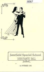 Greensborough Historical Society
Programme - Program, Janefield Special School, Janefield Special School: Debutante Ball 1991, 01/11/1991
Janefield Special School Debutante Ball program 19914 pages, photocopied black text on white paper.janefield, janefield special school, debutante balls -
 Greensborough Historical Society
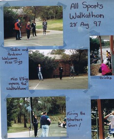
Poster - Digital Image, Greensborough Primary School Gr2062 Walkathon 1997, 27/08/1997
A collection of photographs of the Walkathon at Greensborough Primary School, 1997.Digital copy of colour poster with colour photographs.greensborough primary school, walkathon -
 Greensborough Historical Society
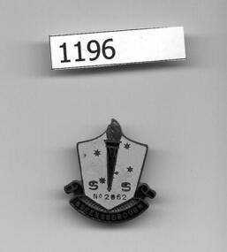
School badge, Greensborough Primary School, Greensborough State School Badge, 1960s
Greensborough Primary School student's badge from the 1960s.An original badge from the 1960s.Metal badge, two-tone blue enamel.Greensborough SS No 2062 in gold-coloured lettersgreensborough primary school -
Greensborough Historical Society
Booklet, Montmorency Primary School, Montmorency Primary School, 75th Anniversary Book 1922 - 1997, 1997
Booklet commemorating 75 years of Montmorency Primary SchoolPhotocopy of Booklet, Text and black and white images [33 pages]montmorency primary school, 75th anniversary, montmorency -
 Federation University Historical Collection
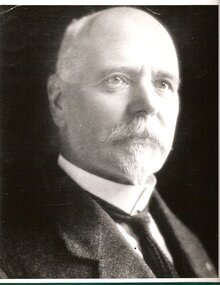
Photograph - Portrait, William Middleton
The Ballarat School of Mines was a predecessor institution of Federation University Australia.A black and white portrait of William Middileton of the Ballarat School of Mines.william middleton, ballarat school of mines, staffmember -
Greensborough Historical Society
Newsletter, Greenhills and North Greensborough Progress Association, Community News: official journal of the Greenhills and Nth. Greensborough Progress Association and the Apollo Parkways Progress Association.. 1st February, 1978. Edition No. 1/78, 01/02/1978
... Community News: official journal of the Greenhills and Nth...Greenhills and North Greensborough Progress Association. ...Aspirations, School news, Are you 92-97-102cm and lethargic?, Parent Australia, On powerlessness, Victoria is procrastinating!, Children - community responsibility, Nursing Mothers Association, Community - Papua New Guinea style. This and that, From the council Chamber.Newsletter, 19 p., illus.greenhills and north greensborough progress association, greenhills, apollo parkways progress association, apollo parkways -
 Stawell Historical Society Inc
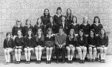
Photograph, Stawell High School Class Photo1974
6975-34 Stawell High School Form 4A, 1974 Form Teacher Mr Moore Back Row, Kaylene Clarke, Carey, Dadswell. Julie Webb, Middle Row, Kristene Slorach, Pam Robson, Lynne Bonney, Kathy Sluga, Heather Rowe, Nancy Allan, Debbie Bell. Maryanne Disher, Front Row, Karen Vendy, Poppy Mangana, Debbie Treloar, Pam Guy, Gayle Redford, Mr Moore, Julie Martin, Jilleen Jenkins. Kathy Herdman, Debbie Iseppi Absent. Valda Martin, Jenny, Shumann, Jenny O'Neill, Ruth West, Margaret Van Leeuwin, Rosemary Springs, Julie Ross. Left Julie Start Students and Teacher Class Photo beside high School wingsStawell High School Form 4A 1974education -
 Ballarat Clarendon College
Book, George Routledge and Sons, History of the war in the penisular and in the South of France from the Year1807 to the Year 1814. Volume I, 1882
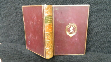
... History of the war in the penisular and in the South of...George Routledge and Sons ...Book prize given to John Tanner (1887), Christmas 1885. First prize for French in the Upper Fifth form.Maroon calf-bound book with gold plate work on spine and borders of cover. Ballarat College school crest and motto inscribed on front cover. Six compartments on spine decorated with gold patterns; title inscribed in second compartment. Volume number inscribed in third compartment Marbled leaf edges and end papersBook plate: Ballarat College crest and motto / French / Upper fifth form / First prize / Awarded to / J Tanner / Christmas 1885john-tanner, 1887, 1885, ballarat-college, book-prize, -
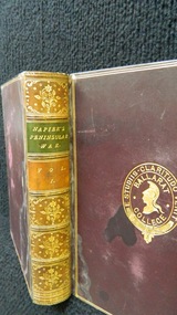
 Ballarat Clarendon College
Book, George Routledge and Sons, History of the war in the penisular and the south of Francers from the Year 1807 - the Year 1814, n.d
... History of the war in the penisular and the south of...George Routledge and Sons ...Book prize given to John Tanner (1887), Christmas 1885. First prize for Mathematics in the Upper Fifth form. Maroon calf-bound book with gold plate work on spine and borders of cover. Ballarat College school crest and motto inscribed on front cover. Six compartments on spine decorated with gold patterns; title inscribed in second compartment. Volume number inscribed in third compartment Marbled leaf edges and end papers Book plate inside front cover: Ballarat College crest and motto / Mathematics / Upper fifth Form / First prize / Awarded to / John Tanner / Christmas 1885john-tanner, 1887, 1885, ballarat-college, book-prize,