Showing 10536 items
matching lander
-
 Eltham District Historical Society Inc
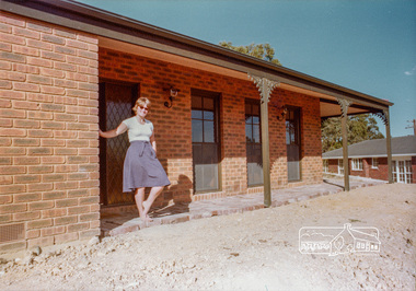
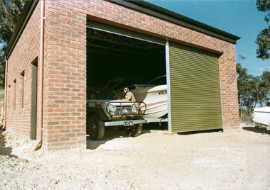
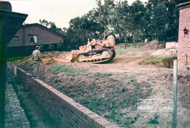
Photograph, 14 Stokes Place, Eltham, April 1980, 1980
14 Stokes Place was the home of Peter and Carla Vermey. The land was purchased in May 1979 and the home built by Peter and Carla Vermey after the developer, Macquarie Builders went bankrupt. Sold October 2017 by Morrison and Kleeman Real Estate. Stokes Place was part of the Stokes Orchard Estate which was developed from the break-up of the the orchard owned by Frank Stokes who lived on the northeast corner of Nyora Road and Eucalyptus Road. His daughter Beryl advised that the Shire had levied a rate assessment on individual parcels of land within the orchard which became unaffordable resulting in its sub-division and sell off. The Stokes Orchard Estate was developed by Macquarie Builders in two stages starting with stage 1 in 1976. Stokes Place was part of Stage 2 in 1979. The Estate was bounded between Nyora Road, Eucalyptus Road, Diosma Road and Stokes Place. The original orchard only just reached the left most portions of Stokes Place and did not go fully up to Diosma, rather to just beyond the extant of Stokes Place. Stokes Place was known within the family as "The Oats" as that is where they grew oats. Frank Stokes moved to Eltham c.1945 after visiting Harold Bird to view his orchard, located diagonally opposite Stokes Orchard from the intersection of Eucalyptus Road, Pitt Street and Nyora Road. It was on Harold Bird's recommendation that Frank purchased the land.The Stokes Orchard Estate collection is typical of housing developments of the late 1970s and 1980s. It was one of the earliest estates in Eltham following the nearby Woodridge Estate development.Digital fileScanned from a print contained in owner's photo album (81 prints in total digitised)stokes place, eltham, stokes orchard, stokes orchard estate, streets, houses, peter and carla vermey -
 Eltham District Historical Society Inc
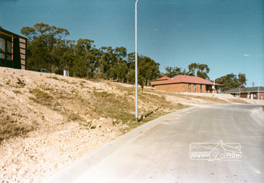
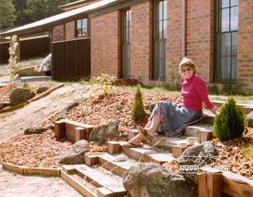
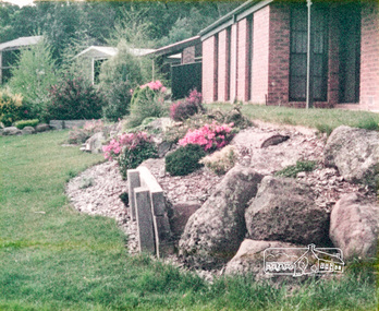
Photograph, 14 Stokes Place, Eltham, 1982, 1980
14 Stokes Place was the home of Peter and Carla Vermey. The land was purchased in May 1979 and the home built by Peter and Carla Vermey after the developer, Macquarie Builders went bankrupt. Sold October 2017 by Morrison and Kleeman Real Estate. Stokes Place was part of the Stokes Orchard Estate which was developed from the break-up of the the orchard owned by Frank Stokes who lived on the northeast corner of Nyora Road and Eucalyptus Road. His daughter Beryl advised that the Shire had levied a rate assessment on individual parcels of land within the orchard which became unaffordable resulting in its sub-division and sell off. The Stokes Orchard Estate was developed by Macquarie Builders in two stages starting with stage 1 in 1976. Stokes Place was part of Stage 2 in 1979. The Estate was bounded between Nyora Road, Eucalyptus Road, Diosma Road and Stokes Place. The original orchard only just reached the left most portions of Stokes Place and did not go fully up to Diosma, rather to just beyond the extant of Stokes Place. Stokes Place was known within the family as "The Oats" as that is where they grew oats. Frank Stokes moved to Eltham c.1945 after visiting Harold Bird to view his orchard, located diagonally opposite Stokes Orchard from the intersection of Eucalyptus Road, Pitt Street and Nyora Road. It was on Harold Bird's recommendation that Frank purchased the land.The Stokes Orchard Estate collection is typical of housing developments of the late 1970s and 1980s. It was one of the earliest estates in Eltham following the nearby Woodridge Estate development.Digital fileScanned from a print contained in owner's photo album (81 prints in total digitised)stokes place, eltham, stokes orchard, stokes orchard estate, streets, houses, peter and carla vermey -
 Eltham District Historical Society Inc
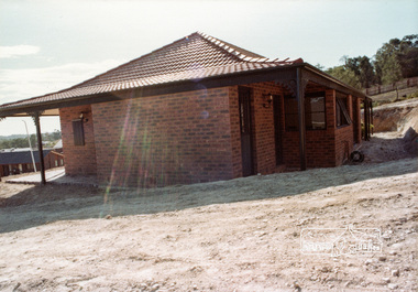
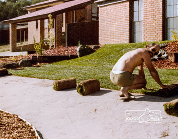
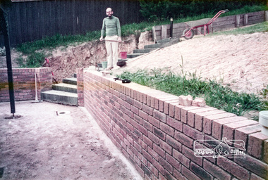
Photograph, 14 Stokes Place, Eltham, October 1983, 1980
14 Stokes Place was the home of Peter and Carla Vermey. The land was purchased in May 1979 and the home built by Peter and Carla Vermey after the developer, Macquarie Builders went bankrupt. Sold October 2017 by Morrison and Kleeman Real Estate. Stokes Place was part of the Stokes Orchard Estate which was developed from the break-up of the the orchard owned by Frank Stokes who lived on the northeast corner of Nyora Road and Eucalyptus Road. His daughter Beryl advised that the Shire had levied a rate assessment on individual parcels of land within the orchard which became unaffordable resulting in its sub-division and sell off. The Stokes Orchard Estate was developed by Macquarie Builders in two stages starting with stage 1 in 1976. Stokes Place was part of Stage 2 in 1979. The Estate was bounded between Nyora Road, Eucalyptus Road, Diosma Road and Stokes Place. The original orchard only just reached the left most portions of Stokes Place and did not go fully up to Diosma, rather to just beyond the extant of Stokes Place. Stokes Place was known within the family as "The Oats" as that is where they grew oats. Frank Stokes moved to Eltham c.1945 after visiting Harold Bird to view his orchard, located diagonally opposite Stokes Orchard from the intersection of Eucalyptus Road, Pitt Street and Nyora Road. It was on Harold Bird's recommendation that Frank purchased the land.The Stokes Orchard Estate collection is typical of housing developments of the late 1970s and 1980s. It was one of the earliest estates in Eltham following the nearby Woodridge Estate development.Digital fileScanned from a print contained in owner's photo album (81 prints in total digitised)stokes place, eltham, stokes orchard, stokes orchard estate, streets, houses, peter and carla vermey -
 Eltham District Historical Society Inc
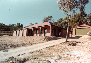
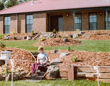
Photograph, 14 Stokes Place, Eltham, October 1983, 1980
14 Stokes Place was the home of Peter and Carla Vermey. The land was purchased in May 1979 and the home built by Peter and Carla Vermey after the developer, Macquarie Builders went bankrupt. Sold October 2017 by Morrison and Kleeman Real Estate. Stokes Place was part of the Stokes Orchard Estate which was developed from the break-up of the the orchard owned by Frank Stokes who lived on the northeast corner of Nyora Road and Eucalyptus Road. His daughter Beryl advised that the Shire had levied a rate assessment on individual parcels of land within the orchard which became unaffordable resulting in its sub-division and sell off. The Stokes Orchard Estate was developed by Macquarie Builders in two stages starting with stage 1 in 1976. Stokes Place was part of Stage 2 in 1979. The Estate was bounded between Nyora Road, Eucalyptus Road, Diosma Road and Stokes Place. The original orchard only just reached the left most portions of Stokes Place and did not go fully up to Diosma, rather to just beyond the extant of Stokes Place. Stokes Place was known within the family as "The Oats" as that is where they grew oats. Frank Stokes moved to Eltham c.1945 after visiting Harold Bird to view his orchard, located diagonally opposite Stokes Orchard from the intersection of Eucalyptus Road, Pitt Street and Nyora Road. It was on Harold Bird's recommendation that Frank purchased the land.The Stokes Orchard Estate collection is typical of housing developments of the late 1970s and 1980s. It was one of the earliest estates in Eltham following the nearby Woodridge Estate development.Digital fileScanned from a print contained in owner's photo album (81 prints in total digitised)stokes place, eltham, stokes orchard, stokes orchard estate, streets, houses, peter and carla vermey -
 Wonga Park Community Cottage History Group
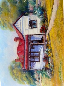
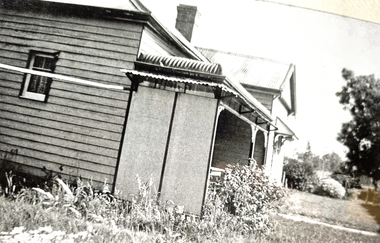
Photograph - Painting, The Hedge, Yarra Road Wonga Park
The Hedge, aka Thomas Knee's house. Thomas Samuel Knee (born c. 1881in Lilydale) married Jane Maggs c. 1912, Thomas Samuel Knee's father Thomas Knee (married to Sarah Hardidge and who it appears was also an orchardist in Yarra Road) was rated for the land as vacant land at the turn of the century (c. 1900) Thomas Samuel Knee rated as owner of vacant land (CA14B of over 20 acres1911-12 and as a house 1912-13, next year CA 14C added making a total of 39 acres. It appears that Thomas Samuel Knee and his wife Jane lived at the property until 1949 when they moved to Montrose. In 1949 it was purchased by Hubert Victor (Vic) Eggleton after they migrated from Banstead in Surrey England. They had four boys Peter (who did a lot of the farming with Gladys), Brian, Michael and Roger. It was mixed farming: lemons, cherries, eggs, chickens and Gladys bred Spaniel dogs too. They had 2 dairy cows and a draft horse. The farm was larger then and was subdivided at a later date. The big dam was added too. the painting of the house was painted by a cousin of the Lusks. Ownership: Thomas Samuel Knee 1912-1949, Eggletons, 1949 - c.1953, then Timms, c. 1953 - early 1970s then Lusks early 1970s to c. 2012. The Lusks built a new house and after that the old house had various tenants. -
 Wonga Park Community Cottage History Group
Photograph - Colour, The Hedge (Tom Knee's House) 278 Yarra Road Wonga Park in 2023
The Hedge, aka Thomas Knee's house. Thomas Samuel Knee (born c. 1881in Lilydale) married Jane Maggs c. 1912, Thomas Samuel Knee's father Thomas Knee (married to Sarah Hardidge and who it appears was also an orchardist in Yarra Road) was rated for the land as vacant land at the turn of the century (c. 1900) Thomas Samuel Knee rated as owner of vacant land (CA14B of over 20 acres1911-12 and as a house 1912-13, next year CA 14C added making a total of 39 acres. It appears that Thomas Samuel Knee and his wife Jane lived at the property until 1949 when they moved to Montrose. In 1949 it was purchased by Hubert Victor (Vic) Eggleton after they migrated from Banstead in Surrey England. They had four boys Peter (who did a lot of the farming with Gladys), Brian, Michael and Roger. It was mixed farming: lemons, cherries, eggs, chickens and Gladys bred Spaniel dogs too. They had 2 dairy cows and a draft horse. The farm was larger then and was subdivided at a later date. The big dam was added too. the painting of the house was painted by a cousin of the Lusks. Ownership: Thomas Samuel Knee 1912-1949, Eggletons, 1949 - c.1953, then Timms, c. 1953 - early 1970s then Lusks early 1970s to c. 2012. The Lusks built a new house and after that the old house had various tenants. -
 Wonga Park Community Cottage History Group
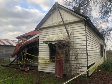
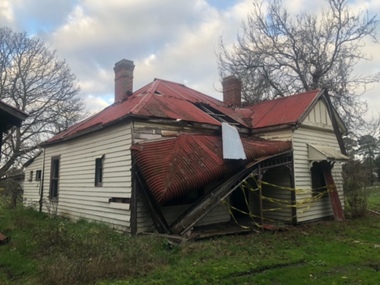
Photograph - Black and White, The Hedge (Tom Knee's House) 278 Yarra Road Wonga Park in 1949
The Hedge, aka Thomas Knee's house. Thomas Samuel Knee (born c. 1881in Lilydale) married Jane Maggs c. 1912, Thomas Samuel Knee's father Thomas Knee (married to Sarah Hardidge and who it appears was also an orchardist in Yarra Road) was rated for the land as vacant land at the turn of the century (c. 1900) Thomas Samuel Knee rated as owner of vacant land (CA14B of over 20 acres1911-12 and as a house 1912-13, next year CA 14C added making a total of 39 acres. It appears that Thomas Samuel Knee and his wife Jane lived at the property until 1949 when they moved to Montrose. In 1949 it was purchased by Hubert Victor (Vic) Eggleton after they migrated from Banstead in Surrey England. They had four boys Peter (who did a lot of the farming with Gladys), Brian, Michael and Roger. It was mixed farming: lemons, cherries, eggs, chickens and Gladys bred Spaniel dogs too. They had 2 dairy cows and a draft horse. The farm was larger then and was subdivided at a later date. The big dam was added too. the painting of the house was painted by a cousin of the Lusks. Ownership: Thomas Samuel Knee 1912-1949, Eggletons, 1949 - c.1953, then Timms, c. 1953 - early 1970s then Lusks early 1970s to c. 2012. The Lusks built a new house and after that the old house had various tenants. -
 Wonga Park Community Cottage History Group
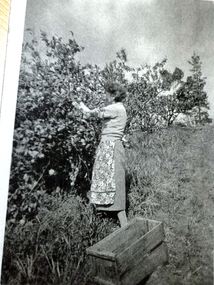
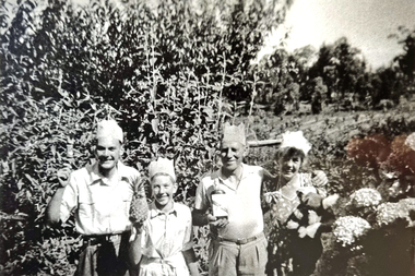
Photograph - Black and White, Wonga Park: Gladys Eggleton picking lemons between 1949 and 1953
The Hedge, aka Thomas Knee's house. Thomas Samuel Knee (born c. 1881in Lilydale) married Jane Maggs c. 1912, Thomas Samuel Knee's father Thomas Knee (married to Sarah Hardidge and who it appears was also an orchardist in Yarra Road) was rated for the land as vacant land at the turn of the century (c. 1900) Thomas Samuel Knee rated as owner of vacant land (CA14B of over 20 acres1911-12 and as a house 1912-13, next year CA 14C added making a total of 39 acres. It appears that Thomas Samuel Knee and his wife Jane lived at the property until 1949 when they moved to Montrose. In 1949 it was purchased by Hubert Victor (Vic) Eggleton after they migrated from Banstead in Surrey England. They had four boys Peter (who did a lot of the farming with Gladys), Brian, Michael and Roger. It was mixed farming: lemons, cherries, eggs, chickens and Gladys bred Spaniel dogs too. They had 2 dairy cows and a draft horse. The farm was larger then and was subdivided at a later date. The big dam was added too. the painting of the house was painted by a cousin of the Lusks. Ownership: Thomas Samuel Knee 1912-1949, Eggletons, 1949 - c.1953, then Timms, c. 1953 - early 1970s then Lusks early 1970s to c. 2012. The Lusks built a new house and after that the old house had various tenants. -
 Wonga Park Community Cottage History Group
Photograph - Black and White, Wonga Park: Eggleton family's first Christmas in Australia 1949
The Hedge, aka Thomas Knee's house. Thomas Samuel Knee (born c. 1881in Lilydale) married Jane Maggs c. 1912, Thomas Samuel Knee's father Thomas Knee (married to Sarah Hardidge and who it appears was also an orchardist in Yarra Road) was rated for the land as vacant land at the turn of the century (c. 1900) Thomas Samuel Knee rated as owner of vacant land (CA14B of over 20 acres1911-12 and as a house 1912-13, next year CA 14C added making a total of 39 acres. It appears that Thomas Samuel Knee and his wife Jane lived at the property until 1949 when they moved to Montrose. In 1949 it was purchased by Hubert Victor (Vic) Eggleton after they migrated from Banstead in Surrey England. They had four boys Peter (who did a lot of the farming with Gladys), Brian, Michael and Roger. It was mixed farming: lemons, cherries, eggs, chickens and Gladys bred Spaniel dogs too. They had 2 dairy cows and a draft horse. The farm was larger then and was subdivided at a later date. The big dam was added too. the painting of the house was painted by a cousin of the Lusks. Ownership: Thomas Samuel Knee 1912-1949, Eggletons, 1949 - c.1953, then Timms, c. 1953 - early 1970s then Lusks early 1970s to c. 2012. The Lusks built a new house and after that the old house had various tenants. -
 Wonga Park Community Cottage History Group
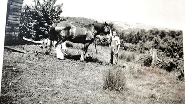
Photograph - Black and White, Wonga Park: Peter Eggleton with Captain, a draught horse between 1949 and 1953
The Hedge, aka Thomas Knee's house. Thomas Samuel Knee (born c. 1881in Lilydale) married Jane Maggs c. 1912, Thomas Samuel Knee's father Thomas Knee (married to Sarah Hardidge and who it appears was also an orchardist in Yarra Road) was rated for the land as vacant land at the turn of the century (c. 1900) Thomas Samuel Knee rated as owner of vacant land (CA14B of over 20 acres1911-12 and as a house 1912-13, next year CA 14C added making a total of 39 acres. It appears that Thomas Samuel Knee and his wife Jane lived at the property until 1949 when they moved to Montrose. In 1949 it was purchased by Hubert Victor (Vic) Eggleton after they migrated from Banstead in Surrey England. They had four boys Peter (who did a lot of the farming with Gladys), Brian, Michael and Roger. It was mixed farming: lemons, cherries, eggs, chickens and Gladys bred Spaniel dogs too. They had 2 dairy cows and a draft horse. The farm was larger then and was subdivided at a later date. The big dam was added too. the painting of the house was painted by a cousin of the Lusks. Ownership: Thomas Samuel Knee 1912-1949, Eggletons, 1949 - c.1953, then Timms, c. 1953 - early 1970s then Lusks early 1970s to c. 2012. The Lusks built a new house and after that the old house had various tenants. -
 Wonga Park Community Cottage History Group
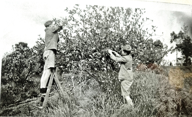
Photograph - Black and White, Wonga Park: Brian and Roger Eggleton picking lemons between 1949 and 1953
The Hedge, aka Thomas Knee's house. Thomas Samuel Knee (born c. 1881in Lilydale) married Jane Maggs c. 1912, Thomas Samuel Knee's father Thomas Knee (married to Sarah Hardidge and who it appears was also an orchardist in Yarra Road) was rated for the land as vacant land at the turn of the century (c. 1900) Thomas Samuel Knee rated as owner of vacant land (CA14B of over 20 acres1911-12 and as a house 1912-13, next year CA 14C added making a total of 39 acres. It appears that Thomas Samuel Knee and his wife Jane lived at the property until 1949 when they moved to Montrose. In 1949 it was purchased by Hubert Victor (Vic) Eggleton after they migrated from Banstead in Surrey England. They had four boys Peter (who did a lot of the farming with Gladys), Brian, Michael and Roger. It was mixed farming: lemons, cherries, eggs, chickens and Gladys bred Spaniel dogs too. They had 2 dairy cows and a draft horse. The farm was larger then and was subdivided at a later date. The big dam was added too. the painting of the house was painted by a cousin of the Lusks. Ownership: Thomas Samuel Knee 1912-1949, Eggletons, 1949 - c.1953, then Timms, c. 1953 - early 1970s then Lusks early 1970s to c. 2012. The Lusks built a new house and after that the old house had various tenants. -
 Glen Eira Historical Society
Document - KAMBROOK ROAD, 46, CAULFIELD NORTH
A copy of a one page typed report by Hilary Bullock and Rosalind Landells of the Brighton Historical Society, dated 14/10/1995, with handwritten notes about this property. It covers the owners of this address from 1918 to 1994 and a short history of the origins of Caulfield Racecourse and land development by 1917. It also mentions the first meeting of the Caulfield Amateur Turf Club in 1859.caulfield north, kambrook road, caulfield cup, caulfield racecourse, racecourses, caulfield amateur turf club, 'kambrook', payne john, balaclava road, swan william h, urquhard john, wenn john, reddon george, may phillip g, griffin g mrs, newton g t (horse trainer), bullock hilary, landells rosalind, bick david, foote henry (surveyor), caulfield roads board, glen eira road, land subdivision -
 Greensborough Historical Society
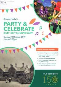
Pamphlet, Leith Park Celebration Day 2019 program, 20/10/2019
A celebration for the 150th anniversary of the establishment of the first Old Colonists Association of Victoria retirement village at Rushall Park North Fitzroy was held on 20 October 2019 at Leith Park St Helena. Leith Park was the Association's second village, built in the 1960s on land donated by Arthur C. Leith, Life Governor, Councillor and President of the Association 1949-1972.4 p. colour pamphlet printed on light cardboardleith park retirement village, old colonists association -
 Greensborough Historical Society
Photograph - Digital image, Portrait of Edward Green, 1850c
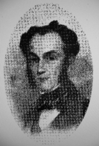
Portrait of Edward Green. In the 1840s, Edward B. Green ran the mail service between Melbourne and Sydney and owned a parcel of land on the Plenty River. He engaged a surveyor to draw up plans and lay out a township on the slopes overlooking the river, and to mark out small farm holdings on the flats. This small township named after him is now Greensborough.Digital copy of portrait.edward bernard green, greensborough history -
 City of Moorabbin Historical Society (Operating the Box Cottage Museum)
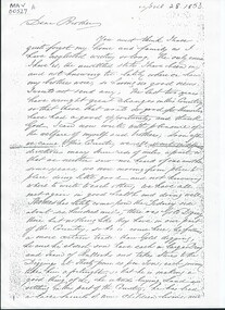
Document, Photocopy Letter Stephen Charman to Michael Charman UK 1853, 1853
Stephen Charman, aged 21 years arrived in Melbourne in 1842 as one of Henry Dendy's emigrants. He established purchased land in 1852 and established a market garden at Spring Grove Cheltenham with his 2nd wife Mary nee Gettens. Stephen died 1906 in Gippsland. He wrote letters to his brother Michael who had remained in England Stephen and Mary Charman were pioneer market gardeners in Moorabbin Shire 1842 and were involved in the development of Church, school and community in the area now called Cheltenham. Charman Road Cheltenham was a boundary of their land. Letter, handwritten from Stephen Charman to his brother Michael in UK 1853 x 3 pages Handwritten signed Stephen early settlers, pioneers, spring grove, city of moorabbin, county of bourke, moorabbin roads board, parish of moorabbin, shire of moorabbin, henry dendy's special survey 1841, were j.b.; bent thomas, o'shannassy john, king richard, charman stephen, charman mary, gettens mary, marigold flowers, pharmacy, methodist church, state schools, education, highett william, ormond francis, maynard dennis, market gardens, -
 Puffing Billy Railway
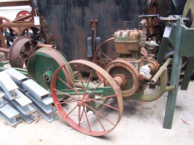
Tool - Drag Saw, New Record Drag Saw, circa 1920s
Circa 1920s petrol driven cross saw. It was mainly used cross cutting felled logs The Land on which the Menzies Creek railway station and Museum are built on was once apart of James Hermon's & his son William Hermon's property on which this Drag Saw was used. reference : Jinkers and Whims: A Pictorial History of Timber-Getting By Jack BradshawHistoric - Industrial Timber working petrol driven cross saw - Drag SawLarge, mechanical saw mounted on a steel shaft connected to tin fuel and water containers. The machine has two large spoked wheels, a rotating Crankshaft and an extended arm/rod attached to a crank and flywheel.New Record puffing billy, drag saw, timber cutting, early mechanical equipment, james hermon & sons, menzies creek, 1920s -
 Hume City Civic Collection
Photograph, late 1980s
This is a photograph of the site and the remains of the Lochton flour mill which was situated on a horse shoe bend along Deep Creek at Bulla. Captain William Morrison Hunter took up land along Deep Creek and built his home in 1850.He opened the flour mill in 1856, which was worked by a number of millers until it ceased operations in 1961.Flour milling was one of the early industries carried out in the Sunbury and Bulla district. The mills were established along Jacksons Creek in Sunbury and Deep Creek in Bulla.A coloured photograph of a tree lined horseshoe bend in a river with the remains of a bluestone building in the bottom RH corner.lochton flour mill, bulla, flour mills, captain william morrison hunter -
 Mt Dandenong & District Historical Society Inc.
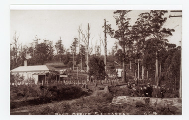
Photograph, Post Office Sassafras, c1930s
View of Hinkley Guest House on the left where the Post Office occupied a room in the front corner. The post operated from 1912 until 1937 when the building burned down. The Post Office then moved up to one of the Cadby Cottages near Rostrevor. The empty block of land next to Hinkley was where Sassafras School was built a few years later.Black and white copy of GGM photograph showing a group of five well dressed men in the foregroundbehind a large log with the Post Office and Telegraph office on the left.On front - POST OFFICE SASSAFRAS G.G.M.sassafras, post office, post office, hinkley, cadby cottages, sassafras school, rostrevor -
 Whittlesea Historical Society Inc.
Photograph, Copy, Mayfield Quarry, Mernda, unknown
The age of the bluestone quarry at Mernda is uncertain, it is believed to date from the early times of settlement in the area, in the mid 19th century. Nearby bluestone buildings such as Mayfield Presbyterian Church and the butter factory at Mayfield may have been sourced from here. Both of these buildings were constructed by Moses Thomas, a very early settler and previous owner of this land.Photo, copy, coloured ink on paperbluestone, moses thomas, quarry, bluestone quarry, mayfield, mernda, mayfield presbyterian church, mernda quarry, 19th century -
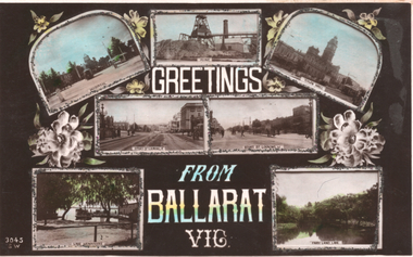 Ballarat Tramway Museum
Postcard - 7 photo panels, J Beagles & Co, "Greetings from Ballarat Vic", c1906
The series of photographs show the Hospital (at Hospital Corner) with two trams, a mine, two photos of Sturt St, Town Hall with a tram, Lake Wendouree and Fairly Land at the Lake. The letter on the rear is a family letter. Published by J Beagles of London, the SW Series - see reference. Undated - based on the reference and logo on the rear of the card, possibly around 1906.Yields information Ballarat and the gloss colour printing of a postcard.Postcard coloured, divided back, with a handwritten letter on rear. Has sparkles or glitter glued around the edges of each photograph. No. "3045 SW"See image 2 for the handwritten letter. tramways, trams, postcards, hospital, sturt st, lake wendouree, mining -
Ballarat Tramway Museum
Postcard - 7 photo panels, J Beagles & Co, "Greetings from Ballarat Vic", c1906
The series of photographs show the Hospital (at Hospital Corner) with two trams, a mine, two photos of Sturt St, Town Hall with a tram, Lake Wendouree and Fairly Land at the Lake. The letter on the rear is a family letter. Published by J Beagles of London, the SW Series - see reference. Undated - based on the reference and logo on the rear of the card, possibly around 1906.Yields information Ballarat and the gloss colour printing of a postcard.Postcard coloured, divided back, with a handwritten letter on rear. Has sparkles or glitter glued around the edges of each photograph. No. "3045 SW"See image 2 for the handwritten letter. tramways, trams, postcards, hospital, sturt st, lake wendouree, mining -
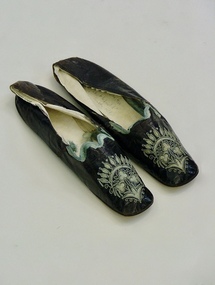 Brighton Historical Society
Shoes, 1850s
These shoes were worn by Emily Cock (nee Smith), the daughter of wealthy early settler John Matthew Smith. From 1856 until 1931 the Smiths lived at 'Castlefield', a mansion on a vast estate that at one time stretched along South Road from Bluff Road to Hampton Street. The land was gradually subdivided, and the house is now a part of Haileybury College.Pair of flat black kid leather indoor shoes decorated with pale blue silk, cut-away applique and embroidery.shoes, embroidery, applique, castlefield, emily smith, brighton