Showing 10391 items
matching plan
-
 Kew Historical Society Inc
Flyer - 60 Pakington Street, Kew
Subdivision plans and real estate flyers/brochures reveal a number of aspects of urban development and history. The Kew Historical Society's collection of these plans, as well as advertisements extracted from magazines, cover key aspects of community development and architectural history of Kew and Kew Eat as well as surrounding suburbs. While most of the plans in the collection were gifted to the Society by the former City of Kew, a number of other plans and advertisements have been donated by individuals, of which this is an example. Single page illustrated flyer, advertising 60 Pakington Street, Kew for sale. Annotation in pen and ink at right.neville collection, 60 pakington street -- kew (vic.), real estate advertisements -- kew (vic.) -
Kew Historical Society Inc
Flyer - 45 Pakington Street, Kew
Subdivision plans and real estate flyers/brochures reveal a number of aspects of urban development and history. The Kew Historical Society's collection of these plans, as well as advertisements extracted from magazines, cover key aspects of community development and architectural history of Kew and Kew Eat as well as surrounding suburbs. While most of the plans in the collection were gifted to the Society by the former City of Kew, a number of other plans and advertisements have been donated by individuals, of which this is an example.Single page illustrated real estate flyer advertising 45 Pakington Street, Kew for sale by auction. Annotation in pen and ink at rightpeter neville, real estate advertisements -- kew (vic.), 45 pakington street -- kew (vic.) -
Kew Historical Society Inc
Booklet - Old Kew Golf Links Estate, 1926
Subdivision plans and real estate flyers/brochures reveal a number of aspects of urban development and history. The Kew Historical Society's collection of these plans, as well as advertisements extracted from magazines, cover key aspects of community development and architectural history of Kew and Kew Eat as well as surrounding suburbs. While most of the plans in the collection were gifted to the Society by the former City of Kew, a number of other plans and advertisements have been donated by individuals, of which this is an example.8-page brochure advertising 80 residential home sites for sale in a subdivision called the 'Old Kew Golf Links Estate'. These sites had historic importance in Kew's history as they had previously belonged to Kodak Pty Ltd who were refused permission by Kew Council to use the land for industrial development. The estate, advertised was advertised as being within five miles of Melbourne. The brochure is notable as it includes photographs of Kew East Primary School, the former Kew Golf Club clubhouse, and 'The Moorings' Boathouse (aka Chipperfield's Boat House). The aerial photograph, overlaid with names of notable sites, on the final page is of interest as it shows the area before the intrusion of the Eastern Freeway, which resulted in changing the course of a section of the Yarra River. old kew golf links estate, subdivision -- kew (vic.), subdivisions -- kew east (vic), chipperfield's boathouse, kew east primary school, kew golf club -
Kew Historical Society Inc
Booklet - Yarraleen Estate, Bulleen, c.1966
Subdivision plans and real estate flyers/brochures reveal a number of aspects of urban development and history. The Kew Historical Society's collection of these plans, as well as advertisements extracted from magazines, cover key aspects of community development and architectural history of Kew and Kew Eat as well as surrounding suburbs. While most of the plans in the collection were gifted to the Society by the former City of Kew, a number of other plans and advertisements have been donated by individuals, of which this is an example.Original 8-page booklet advertising a new residential development in Bulleen entitled 'Yarraleen'. The glossy multi-colour brochure includes historic and contemporary photographs of the Yarra Valley, graphic designs of potential residential development, photographs of key facilities (Marcellin College, Golf links, local swimming holes, the Beaver Swim School, Carey Grammar School Oval and grandstand, shopping strips, and farmland).subdivisions -- bulleen (vic.), yarraleen estate -
 Robin Boyd Foundation
Document - Speech, Professor George Seddon, Graduation address, 12.04.1986
A graduation address given by Professor George Seddon, Dean of Faculty of Architecture and Planning, University of Melbourne in 1986. The speech compares urban planning and architecture in Melbourne and Boston. Seddon mentions Boyd positively as a former Melbourne University student and a key writer and thinker on Australian architecture and planning (pages 5&6).Typewritten, A4, 12 pages. Plus with compliments card from Seddon, noting to view pages 5 and 6.melbourne, boston, robin boyd, george seddon, kevin lynch, university of melbourne -
Glen Eira Historical Society
Plan - Pascoe Avenue, 26, Bentleigh
Document detailing two valuations by National Trustees Co of the property at 26 Pascoe Ave, Bentleigh, the first valuation is dated 14/07/1954 and the second dated 19/07/1957. Included are handdrawn plans, handwritten notes and typed valuations listing values of architectural features, and correspondence from National Trustees Co. for both 1954 and 1957. The 1954 documents were clearly used in the 1957 valuation.pascoe ave, land subdivisions, land values, bentleigh, pergolas, architectural features, parish of moorabbin, plans, architectural styles, county of bourke, maps, brick houses, national trustees co, illustrations, dendy’s crown special survey -
 Robin Boyd Foundation
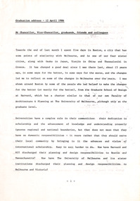
Document - Manuscript, Robin Boyd, Albert Park Protection League
Criticism of the state of Albert Park, Melbourne, preparation of a current map, the need for a Master Plan of buildings, plantings, furniture. Criticism of buildings. Suggests a plan to plant and paint.This appears to be a lecture.Typewritten with pencil edit and notes, quarto, 4 pages. (Two copies)Small paper square included with Monday, January 24 calendaralbert park, macrobertson girls high school, planting, building, furniture, robin boyd, manuscript -
Glen Eira Historical Society
Plan - Centre Road, 734, Bentleigh East
A one page typed letter, dated 30/09/1970 addressed to S P Simmonds Estate Agency from William Lasica and Co Solicitors requesting a valuation of the property at 734 Centre Road, Bentleigh East. The file also includes four pages of handwritten, undated and unattributed working notes with property description, calculations and a rough plan (96mm x 94mm) of the ground floor of the building for the valuation. Also included in the file is a two page duplicate copy of a typed letter, dated 08/10/1970 from W V Scott to William and Lasica Co Solicitors containing the valuation of the relevant property and rental details. The file also includes a one page photocopy of a handwritten document dated 15/11/1967. It gives details of a previous mortgage. The file also includes a photocopy, dated 26/09/1970, of the Certificate of Title of Lot 6 of Subdivision No 60044 Parish of Moorabbin. It includes a plan of the property (139mm x 123mm).klauss anna sara, klauss edward, green william james, green margaret estelle, green william thomas, myers thomas lee, lombard joseph patrick, graham george kinnell, tobin thomas norman, mcintosh edward joseph, bentleigh east, east bentleigh, centre road, bentleigh station, omeo court, east boundary road, s p l constructions pty ltd, r k c nominees pty ltd, maryland street caulfield investors, flats, land values, land titles, rents, renting, \ -
 Federation University Historical Collection
Plan, Station Reserve Bakery Hill, Ballaarat
.1) Oversized photocopy of large plan depicting railway right of way where Mair and Humffray Streets meet. Main landmarks include Duke of Richmond Hotel, Prince of Wales Hotel, Duke of York Hotel, Welcome Nugget Claim and Shaft, Imperial Hotel, Union Hotel, Kingston St, Otway St, Wellington Claim, Gravel Pits Gold Working and Robert Burns Hotel. .2) Same of above. station reserve, bakery hill, railway, ballarat, mair street, humffray street north, duke of york hotel, duke of richmond hotel, union hotel, kingston st, otway st, wellington claim, gravel pits, gold workings, robert burns hotel -
Port Melbourne Historical & Preservation Society
Plan, A J Duncan, Draughtsman, Plans and Sections of Tramsway, May 1891
Plans and typeset descriptions of a proposal to run a cable tram under the Yarra from Williamstown to Melbourne (Falls Bridge) via Port Melbourne. Oriniginally submitted to Victorian Legislative Assembly 1889; this updated 1891 version has 10 pages, and includes an added section to take tramway to Sandridge Road as far as St. Kilda Road. A company has now formed to back the proposal being re-presented to the Legislative Assembly.Signed by Edward Clark 2-6-1891, with Borough stamp on cover; initialed, ditto, on page 2; signed by A.J. Duncan page 2.transport - tramways, town planning - proposals shelved, williamstown, edward clark, town clerks, mr jennings, austral - anglo tramway and general agency co ltd, a j duncan -
University of Melbourne, Burnley Campus Archives
Plan, A. Lucy, Burnley Gardens Site Works, 1958
Plan showing layout of Gardens bound by Swan St and the Yarra Boulevard. Buildings shown include Fernery, Silo, Residence, Glasshouses, Manure Bins, Store, Milking Sheds, Admin. Building, Laying Sheds, Breeder Shed, Chicken Run, Potting Shed and Plant Research Lab. Also showing proposed paths and kerbing. Public Works Dept., Chief Engineer's Dept. drawn by A. Lucy. Scale 1 in:40 ftgardens, sheds, glasshouses, buildings, a. lucy -
 Bendigo Historical Society Inc.
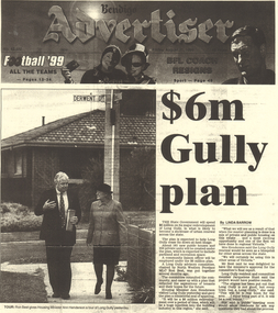
Document - LONG GULLY HISTORY GROUP COLLECTION: $6M GULLY PLAN
Photocopy of the front page of the Bendigo Advertiser Friday August 20, 1999. The article titled $6m Gully plan by Linda Barrow mentions a building plan for the area. It has a photo of Ron Best MLC and Housing Minister Ann Henderson on a tour of Long Gully. There is a small article about Phil White, The Herald Sun/Monash University Teacher of the Year Award.bendigo, history, long gully history group, the long gully history group - $6m gully plan, bendigo advertiser20/8/1999, ron best, ann henderson, jacquelene hunt, phil white, golden square secondary college, herald sun, monash university, graeme fryar, racv, ashmans, linda barrow -
Bendigo Historical Society Inc.
Map - CAMPBELL COLLECTION: BENDIGO AND DISTRICT MAPS, 8-7-29
Map. Rifle Range, Parishes of Wellsford and Sandhurst. Scale 20 chains to 1 inch. Total area in plan is 5916 acres. Wallan and Bendigo Railway to Axedale Township and station 8 miles, to Longlea Railway Station 2 1/2 - 3 miles. Rifle Range. Compiled in W.P.B. from Assessment and Parish Plans, by H.A.D. 8-7-29H.A.D.(Darby).map, bendigo, allotments -
Bendigo Historical Society Inc.
Document - MARKS COLLECTION: PLAN LANSELL'S COMET PROPRIETARY MINE BENDIGO
Plan ( engineering drawings ) for construction of crushing and elevating plant at Lansell's Comet Proprietary Mine, Bendigo. Drawings show detail for crusher and elevator, brick foundations. Plan is annotated with e.g. number of revolutions of jaw crusher. On bottom written in black pen: arrangement crushing and elevation plant for Lansell's Proprietary Comet Mine Bendigo, Hargreaves & Daggar, Consulting Engineers, Victoria Chambers.mining, crushing & milling, lansell's comet mine -
 Melbourne Tram Museum
Pamphlet, Yarra Trams, "Power supply upgrade project - J. S. Grey Reserve West Preston", Jul. 2016
Digital image of a folded A4 pamphlet titled "Power supply upgrade project - J. S. Grey Reserve West Preston", about the construction of a new sub-station on the reserve, gives construction dates, impact, site plan, elevation plan, reason or need for the sub-station for tram power upgrades. Dated July 2016. A4 print made for files.trams, tramways, substation, power supply, yarra trams, west preston -
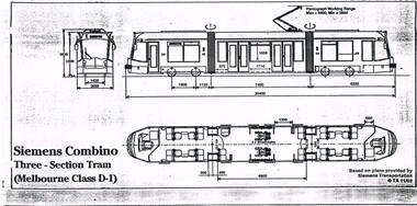 Melbourne Tram Museum
Drawing, Transit Australia Publishing, "Siemens Combino Three Section Tram (Melbourne Class D1)", "Siemens Combino Three Section Tram (Melbourne Class D2)", Nov. 2002
Set of two drawings of the Melbourne Siemens Combino Trams, class D1 and D2, produced by Transit Australia, November 2002, based on plans from Siemens Transportation. Side and end elevations and floor plans with leading dimensions. .1 - "Siemens Combino Three Section Tram (Melbourne Class D1)" .2 - "Siemens Combino Five Section Tram (Melbourne Class D2"trams, tramways, drawings, tramcars, d class, tramcar design -
 Bendigo Military Museum
Booklet - HANDBOOK of VOLUNTARY AID DETACHMENTS 1942 & 1943, Aust Army, 1942
VAD. To supplement the medical services of the Navy, Army and Air Force in time of War. Part of a collection re Bendigo Voluntary Aid Detachment. Refer Cat 7028 for the collection.1. This is a small pocket book. The cover is a light Khaki. Printing is in black ink. Title - Handbook of Voluntary Aid Detachments, Aust. Part 1, 1942. It has 23 pages of plans, army org and uniforms for VAD girls. 2. Small pocket book as above. Dated 1943. It has 24 pages of plans, Army Org and uniforms for VAD girls.1. Written on front cover is “D. M. Guest” Inside are numerous pencil amendments to regulations. 2. On front cover is a fraction of a black rubber stamp like a Post Office stamp.ww2, vad, booklets -
Bendigo Historical Society Inc.
Book - MINING REPORTS - THE CONFIDENCE GROUP OF MINES BULLETIN NO 41
Light brown covered booklet 'Bulletins of the Geological Survey of Victoria issued by W Dickson, Secretary for Mines, Under the Authority of the Hon. S Barnes M L A Minister of Mines. No 41 The Confidence Group of Mines, Bendigo with Plans and Sections by H S Whitelaw, Field Geologist, dated 1918. Mines mentioned are: Confidence Extended Mine, Confidence Tribute Company and the Central Windmill Hill Mine. Mentioned in the report are crushings and gold yield, details of levels, names of leases along the reef. Extracts from Mine Manager's Half-yearly Reports, 1878-1915 of tons crushed and gold yield. Plans and sections of the Confidence Extended Mine on the Garden Gully Line of Reefs are: Plate I General Plan of All Levels, Plans of Levels Plate No II, Plans of Levels Plate No III, Transverse Section Plate No IV, Longitudinal Section Plate No V, and Central Windmill Hill Mine Transverse Section Plate No VI. Plates signed by H S Whitelaw 17 & 18/6/16 and 20/7/16.book, bendigo, mining reports, mining reports, the confidence group of mines bulletin no 41, confidence extended mine, confidence tribute company, central windmill hill mine, department of mines, bulletins of the geological survey of victoria, w dickson, the hon s barnes, h s whitelaw, h j green, mr robert eddy, mr w h cundy, j foster, c j thompson -
 Surrey Hills Historical Society Collection
Compact disc, Melbourne Directory 1884 (Sands & McDougall)
The Sands and McDougall directories are amongst the most comprehensive. You can find out more details about places in which people lived, the other residents in the area, the services available in the region...all of which help to paint a picture of your ancestors' life. Apart from the Street, Alphabetical, Trade and Professional directories, this volume also contains Government and Official, Ecclesiastical, Legal, Municipal, Colonial, Societies and Institutions directories. A fascinating feature in this volume is a Universal Building Societies Supplement which includes 15 pages of architectural house plans of the day - layouts and elevations - with the house price for each.The Sands and McDougall directories are amongst the most comprehensive. You can find out more details about places in which people lived, the other residents in the area, the services available in the region...all of which help to paint a picture of your ancestors' life. Apart from the Street,Alphabetical, Trade and Professional directories, this volume also contains Government and Official, Ecclesiastical, Legal, Municipal, Colonial, Societies and Institutions directories. A fascinating feature in this volume is a Universal Building Societies Supplement which includes 15 pages of architectural house plans of the day- layouts and elevations- with the house price for each.streets, trade, agriculture, government, legal, ecclesiastical, farmers, farm workers, clergy, plans, timber houses, brick dwellings, buildings, structures and establishments -
 Phillip Island and District Historical Society Inc.
Booklet, Cowes McRae Beach Estate, 1960s
This land was owned by the McRae family, whose wife was a Justice. Hence the street names of McRae and Justice. The weatherboard family home [ originally a guest house called Glen Isle] was at the end of the current Justice Road. The estate was created in the mid 1960s. The house was put on skids and dragged by two tractors and a bulldozer to 364 Church Street while the family home was built at 368 Church Street, Cowes.[ Source Sandra Rocotas, nee McCrae. Facebook Community Noticeboard 5/2/2023. Permission given to use information and photos ] Estate was sold by Rogan Real Estate.HistoricalColoured A4 brochure describing the McRae Beach Estate, including plan of streets and location on Island, photos and description of the Island. Sold by Rogan Real Estate.Cowes McRae Beach Estate - Right in the heart of things .Phillip Island - The Loveliest Isle on Earthhousing, justice family, mcrae family, glen isle guesthouse, cowes west, rogan real estate cowes phillip island -
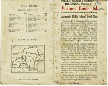 Phillip Island and District Historical Society Inc.
Booklet, Authentic Phillip Island Road Map, Pre 1960
Tourist brochure printed by the Phillip Island Printers pre 1960HistoricalSmall cream coloured brochure with details of accommodation, transport and animals. Inside is a map of the Island with numbered points of interest. There is also a plan of Cowes and drawings of animals.Visitors' Guide 6d Authentic Phillip Island Road Maptourist brochure, road map -
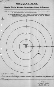 Ringwood and District Historical Society
Plan of magazine site, Mines Dept, Explosives Magazine Licence and Maps, Wonga Rd Ringwood. 1940, 1936, 1938-1940
Plans for the magazine site in Ringwood, located at Wonga Road, Ringwood. Magazine licence 2 pages. Area map showing Warrandyte, Ringwood and Deep Creek. -
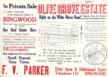 Ringwood and District Historical Society
Flyer, Land Sale Advertisement, Olive Grove Estate, Ringwood, Vic. - 1926
Further development of 9 shop sites took place along Whitehorse Road (later street numbers 58 to 64 Whitehorse Road) between New Street and Olive Grove around 1950 - See Victorian Collections reference 5227.Single sided page with red and blue print advertising Olive Grove Estate business and residential allotments, including subdivision plan and summary of local services.Subdivision includes Whitehorse Road, New Street, and Olive Grove. Agent - F.V. Parker, Telephone 131, Ringwood. -
 Kiewa Valley Historical Society
Paper Sheet - Shire of Bright Plans
Oblong sheet of paper - bright yellow (or orange). Black typed writing and subdivision maps of the Kiewa Valley Planning Scheme in the Shire of Bright. Circa 1980s2 pages of maps and scriptshire of bright, maps, kiewa valley -
 Bendigo Military Museum
Accessory - NOTEBOOK, Government, c.1939-45
Benjamin Thomas Roy Chadd No's 10594, VX20311, 1st, 1st and 2nd AIF. Refer 2039 for service history also 2034P. Cotton covered brown cardboard Army book No 153. Contains numerous pencil entries of an officers orders & plans during Middle East campaigns WWII.Inside cover has signature of BTR Chadddocuments - notebooks, military history-army -
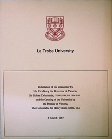 Greensborough Historical Society
Program, La Trobe University: Installation of Chancellor and opening of the University 1967, 08/03/1967
Installation of Chancellor Sir Archibald Glenn at La Trobe University by Sir Rohan Delacombe, Governor of Victoria. Official opening of La Trobe University in Bundoora on 8th March 1967 by Premier Sir Henry Bolte. Contains background on the development of the university.Celebration of the establishment of the Third University of Victoria. Named after after Charles Joseph La Trobe, Victorias first Lieutenant Governor. It will grow to serve Victoria's North Western Community. The Setting is River Red Gums and grass lands which will be be maintained throughout.Manila coloured card folder with red coloured coat of arms of La Trobe University on cover. Development Plan of university on back cover. (3 copies)la trobe university, bundoora, archibald glenn. -
 Kiewa Valley Historical Society
Maps - Bogong High Plains & Mt Beauty Township
The SECV continually updated their mapsDuring the development of the KHES the SECV had to continually update their mapsBoth Foolscap 1. Titled: High Plains Access Tracks & Roads 2. Mt Beauty Street Plan by SECV with Section Nos. and house numbersBoth have sticky tape marks on their back.khes maps -
Ringwood and District Historical Society
Survey map, Macey, H.J, Survey map of part of Ringwood 1917, 1917
Area corresponds to the present Eastlands complexPlan of the crown portion 12 of Parish of Ringwood, County of Mornington showing Adelaide Street and Whitehorse Road. Made by H.J. Macey, Licensed Surveyor 1917. -
Bendigo Historical Society Inc.
Map - PLAN OF VICTORIA HILL AREA, 1971
Bendigo Historical Society feature Plan of the Victoria Hill area. Printed on Paper. B & W. Compiled by AHG Survey Regiment.CMF Increment May 1971bendigo, gold mining, victoria hill -
Bendigo Historical Society Inc.
Map - PLAN OF VICTORIA HILL AREA, 1971
Bendigo Historical Society feature Plan of the Victoria Hill area. Printed on Acetate. B & W. Compiled by AHG Survey Regiment.CMF Increment May 1971bendigo, gold mining, victoria hill