Showing 12416 items matching " railway"
-
 Whitehorse Historical Society Inc.
Article, Industry Began With Rail Line, 24/11/1982 12:00:00 AM
Article about the boost provided to local industry by the opening of the railway line to Lilydale in 1882Article about the boost provided to local industry by the opening of the railway line to Lilydale in 1882Article about the boost provided to local industry by the opening of the railway line to Lilydale in 1882railways, clay industries, white brothers, tile factories, mitcham brick and pottery co. ltd, brickworks -
Whitehorse Historical Society Inc.
Article, New station to set rail standards, 23/10/1991 12:00:00 AM
Nunawading to get new architect designed railway station to provide added safety to travellers.Nunawading to get new architect designed railway station to provide added safety to travellers.Nunawading to get new architect designed railway station to provide added safety to travellers.railways, nunawading railway station, public transport corporation -
Whitehorse Historical Society Inc.
Document, Railways advertising contract, 13/08/1962 12:00:00 AM
Contract with the Victorian Railways for an advertisement for St John's Anglican Church to be placed at Blackburn Station.Contract with the Victorian Railways for an advertisement for St John's Anglican Church to be placed at Blackburn Station.Contract with the Victorian Railways for an advertisement for St John's Anglican Church to be placed at Blackburn Station.blackburn railway station, st johns anglican church, blackburn, victorian railways -
Whitehorse Historical Society Inc.
Map, City of Nunawading, n.d
Map of the City of Nunawading with streets and railway stations namedMap of the City of Nunawading with streets and railway stations named Scale 1 mile = 3.75 inMap of the City of Nunawading with streets and railway stations named city of nunawading, maps -
 Whitehorse Historical Society Inc.
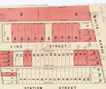
Document, Plan of Blackburn
Copy of plan of Blackburn areaCopy of plan of Blackburn area bounded by Whitehorse Road, Station Street and Railway ParadeCopy of plan of Blackburn arealand subdivision, blackburn, whitehorse road, station street, railway road, vine street -
 Whitehorse Historical Society Inc.
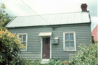
Photograph, House in Blackburn
Coloured print from a 110 slide of a house in Blackburn c1900 in vicinity of Railway Paradeblackburn, cottage, railway road -
Whitehorse Historical Society Inc.
Article, Campaign Gets Results, 2016
Two lifts will be installed at the Blackburn Railway Station as part of the level crossing removal project.Two lifts will be installed at the Blackburn Railway Station as part of the level crossing removal project.Two lifts will be installed at the Blackburn Railway Station as part of the level crossing removal project.blackburn railway station, whitehorse disability advisory committee, railway crossing -
 Whitehorse Historical Society Inc.
Photograph, Blackburn General Store 1908
Used in 'Blackburn - a picturesque history' by Robin Da CostaBlack & white photo of interior of General Store, 93-97 Railway Road, Blackburnrailway road blackburn, nos 93-97, general stores -
 Whitehorse Historical Society Inc.
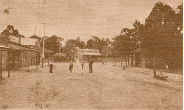
Postcard, Blackburn Road
Black and white Postcard of Blackburn Road looking North from the Railway Gates, 1920.blackburn road, blackburn -
 Whitehorse Historical Society Inc.
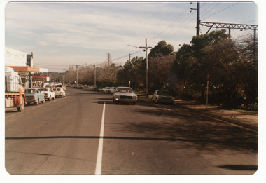
Photograph - Coloured photograph, South Parade, Blackburn, 2/08/1979 12:00:00 AM
Coloured photo of South Parade, Blackburn showing area of proposed railway extensions in 1979blackburn railway station, south parade -
 Whitehorse Historical Society Inc.
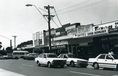
Photograph, Nunawading Shopping Centre
A black and white photograph of the Nunawading shopping Centre taken from the south of the railway stationnunawading shopping centre, shopping centres, nunawading -
 Otway Districts Historical Society
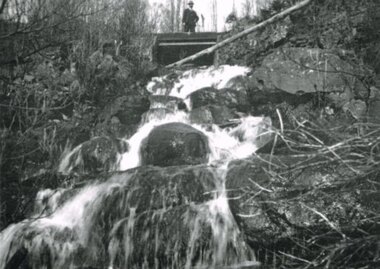
Photograph, Waterfall between Dinmont and Ditchley, 1919, 1919
B/W. Between Dinmont and Ditchley, a man on a railway bridge overlooking a waterfall in 1919. dinmont; ditchley; beech forest; waterfall; railways; -
 Ballarat Tramway Museum
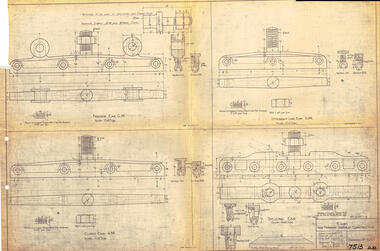
Drawing, Victorian Railways (VR), Ears for Tramway Overhead Construction, 1924
Gives the design details of the device or fitting known as a trolley wire ears that holds a tramway copper trolley wire in position. Notes that the drawing was traced in 1924 from a MMTB drawing. Has details for a splicing ear, straight line ear. feeder ear and curve ear along with details for nuts and screws.Yields information about the design of four different types of trolley wire fittings and how they were fabricated for use on the two tram lines, or electric street railways operated by the Victorian Railways.Dyeline print of Victorian Railways drawing number 4057 - Ears for Tramway Overhead ConstructionHas number "7513 D.33" in black pen in bottom right hand corner.tramways, trams, overhead, victorian railways, trolley wire, engineering, electrical engineering -
 8th/13th Victorian Mounted Rifles Regimental Collection
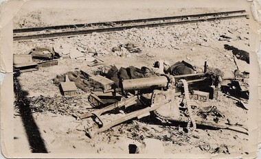
Photograph
Black and white photograph of collection of weapons and other debris beside a railway line in desert -
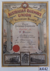 Stawell Historical Society Inc
Memorabilia - Realia, 1936
Australian Railways Union Victoria Branch, Past Officers Certificate (W. Baker 1936)stawell -
Canterbury History Group
Document - Regulation 180, 24 February 1888
Memo from the Victorian Railways of proceedures to be followed before a "Line Clear" can be given.canterbury, canterbury station, canterbury road, victorian railways, railway lines -
 City of Kingston
Photograph - Black and white, c. 1960
One image from a collection of images produced by Public Transportation Corporation showing train stations and other public transport options around the (now) City of KingstonBlack and white photograph of Highett railway station and nearby shops, Highett Road, Highett.Stamped in blue ink on reverse: COPYRIGHT / Public Transport Corporation / For re-ordering photographs / Please quote negative No H3986 / Enquiries C/- PTC Photographic Unit / Telephone switchboard 619 111highett, railway station, strip shopping -
Port Melbourne Historical & Preservation Society
Photograph - Railway Club Hotel, Raglan Street, Port Melbourne, Ron Laing, 1990s
Part of Ron Laing's collection of photographs recording Port Melbourne over a thirteen year period. Donated to the PMH&PS by the photographer.From a group of Ron Laing photographs of Port Melbourne hotels, 1990s: Railway Clubbusiness and traders - hotels, ron laing, railway club hotel -
Port Melbourne Historical & Preservation Society
Photograph - Illustration, Sandridge waterfront, 1859
Photographic copy of illustration of Sandridge waterfront from Sugar Mill, with Town and Railway Piersvarious numbers, and incorrectly identified as 'Gov. Pier Sandridge 1859'piers and wharves - town pier, piers and wharves - railway pier, built environment -
 Kew Historical Society Inc
Photograph - Kew Branch Line : The Hawthorn Grove crossing, August 1952
The Kew railway was opened in 1887, and diverged from the main (Box Hill–Lilydale) line about half-way between Hawthorn and Glenferrie. From the point of divergence the line was slightly less than one mile long, and it had only one intermediate station — Barker. There were four road over-bridges and two level crossings, including one over the busy Barkers Road. The line supported a passenger and goods service, and was electrified in December 1922, at the same time as the main line to Box Hill. There were a number of peak hour services which ran from Flinders Street station (Melbourne) to Kew, but in 1938 all but one of these were diverted to the Ashburton line, where traffic was growing. This had an adverse effect on Kew traffic, as passengers from Kew needed to cross over a footbridge at Hawthorn to change trains, and the main line trains were usually already crowded by the time they reached Hawthorn. At about the same time the off-peak trains were replaced by road buses. In 1952 all passenger trains were withdrawn, but the road bus service continued for many years. Goods trains were finally withdrawn in 1957, and the railway was dismantled in 1958-59. (Source: Frank Stamford, 'The Hawthorn - Kew Railway')Small black and white snapshot of the Hawthorn Grove crossing, August 1952. The photograph, one of 12, is part of a larger album of newspaper clippings, timetables, tickets and photos relating to the Kew Railway Line, taken and compiled by Lachlan Richardson, while a resident of Kew. The album dates from the 1950s. The album is part of a larger subject file on the Kew Line, compiled over time by members of the Kew Historical Society.kew railway line, transport -- railways -- kew (vic.), kew branch line, hawthorn grove -- hawthorn (vic.), railway crossings -
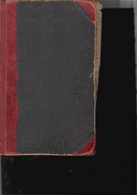 Bendigo Historical Society Inc.
Book - RAILWAY COLLECTION ALPHABETICAL REGISTER OF RAILWAY EMPLOYEES
Railway collection Damaged Hard backed RAILWAYS COLLECTION Alphabetical Register of Railway Employees Circ. 1940s 1950s / Black cardboard cover with red binding .Pages are alphabetically indexed ..Each right hand page has columns for Name , Address , date of birth , marital status and , 1st date .Left hand pages show Staff Transfers , Appointments , Resignations , Terminations etc.book -
Bendigo Historical Society Inc.
Map - AXEDALE, COUNTIES OF BENDIGO & RODNEY, 8-2-26
Map, Axedale, Counties of Bendigo & Rodney, Wellsford, Strathfieldsaye, Eppalock, Knowsley, Weston, Muskerry, Ellesmere, Town of Axedale, Longlea Railway Station, Axedale Railway Station, Wallan & Bendigo Railway. Campaspe River.Axe Creek. By authority H.J.Green, Govt. Printer. Photo-Lithographed at the Dept. of Lands and Survey, Melbourneby W.J.Butson 8-2-26. Price 1/-. (number 60 in map cupboard 1)H.J.Green, Govt. Printer.map, bendigo, axedale -
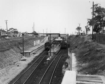 City of Kingston
Photograph - Black and white, Public Transport Corporation, c. 1959
Black and white photograph of Moorabbin railway station, at the completion of works to relocate it to below street level. There are two "red rattler" trains pulled in to the station, utilising each of its two tracks and two of its three platforms. A third platform is visible to the left of the image, but no tracks have been laid to allow for an additional train. This image is part of a larger collection of images from the Public Transport Corporation displaying train stations and streetscapes in what is now the City of Kingston.Black and white photograph of Moorabbin railway station, at the completion of works to relocate it to below street level. There are two "red rattler" trains pulled in to the station, utilising each of its two tracks and two of its three platforms. A third platform is visible to the left of the image, but no tracks have been laid to allow for an additional train. Stamped in blue ink on reverse: COPYRIGHT / Public Transport Corporation / For re-ordering photographs / Please quote negative No M6859 / Enquiries C/- PTC Photographic Unit / Telephone switchboard 619 111moorabbin, railway station, red rattler, public transport -
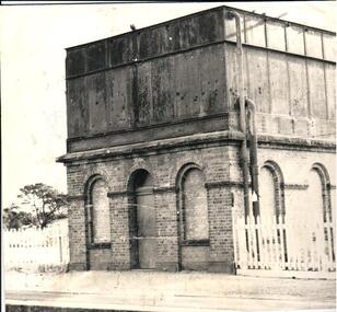 Hume City Civic Collection
Photograph, c 1974
The mounted photograph is one of a series used for display purposes. The water tower at Sunbury Station was built in 1861 by J. Bett. it is of state significance and is an indicator of the importance of the railway to Sunbury's expansion in the Nineteenth Century. Steam trains needed sufficient steam power to climb the steep gradients over the Great Dividing Range and the water tower at Sunbury was used to replenish the trains' water supply for the remainder of the journey.A black and white photograph of the water tower at Sunbury Railway Station. The base of the tower is a brick construction with an arched doorway and two bricked in arched windows at either side of the doorway and a further two bricked in arched windows on the side. Above the base is a large square iron water storage tank with two downpipes at the side. There is a picket fence either side of the building. Mounted on board.sunbury railway station, water towers, victorian railways, bett, j., george evans collection -
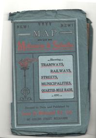 Melbourne Tram Museum
Map, Sands McDougall, Map of Melbourne and Suburbs showing Tramways, Railways, Streets, postal districts, Quarter-Mile Radii etc", c1922
Shows railways, cable and electric tram lines c1922. One of a number of maps produced by Sands McDougall of Collins St. Includes the Zoo horse tram lines. See acquisition and Research note by Duncan McAuslan. See items 2885, 6573, amd 6917 for other editions. On inside cover has current postal rates (including a war surcharge) and places worth visiting and on the rear cover, is an advertisement for Imperial ink.Yields information about Melbourne c1922 and its public transport lines. Produced by Sands and McDougall Pty Ltd of Collins St Melbourne. Folded sheet of paper 6 sections wide x 6 sections or folds deep contained within a green paper cover titled "Map of Melbourne and Suburbs showing Tramways, Railways, Streets, postal districts, Quarter-Mile Radii etc", showing both cable and electric tramways. maps, melbourne, cable trams, tramways, railways, horse trams, vr trams, sands mcdougall, zoo horse tramway, mmtb -
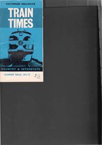 Bendigo Historical Society Inc.
Book - RAILWAYS COLLECTION: TRAIN TIMES COUNTRY AND INTERSTATE SUMMER ISSUE 1971/72
RAILWAYS COLLECTION- Victorian Railways train times country and interstate - summer issue 1971/72 as at Nov 1, 1971 price 5c, glossy cover in blue, black and white showing a Diesel train on the front, first page is loose.railways, bendigo to melbourne -
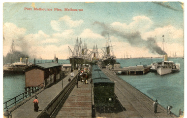 Port Melbourne Historical & Preservation Society
Postcard - Railway Pier, Port Melbourne, 1914
Collected by Alison Kelly when she was caretaking the Missions to Seamen Building 1987-90.One of six postcards, mostly various angles and times of Railway Pier, Port Melbourne. Hand Coloured postcard - Railway Pier viewed out into Bay. Three vessels at pier, two paddle steamers, train in foreground and ships in Bay.piers and wharves - railway pier -
 Ballarat Tramway Museum
Photograph - Black & White Photograph/s, Mar. 1947
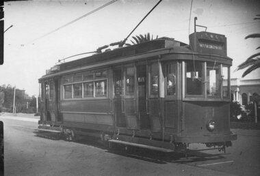
Yields information about the appearance of Geelong tram No.21.Black and white photograph of Geelong 21 in the City area, railway station?? No details of photograph or date, on Agfa paper. Dave O'Neil confirmed June 30/2009, at the railway station, note the double trolley wire. See Related documents.tramways, trams, geelong, railway station, tram 21 -
 Kew Historical Society Inc
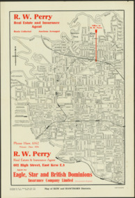
Map - Map of Kew and Hawthorn Districts
Map of Kew, East Kew and Hawthorn produced for a Kew Real Estate Agent, RW Perry. The map is undated.Two-colour map of Kew and Hawthorn Districts produced for by R.L. Jarrett for RW Perry, Real Estate & Insurance Agent. The map has unusual features such as a planned railway link from Kew Station to the former Outer Circle Railway. RW Perry / Real Estate & Insurance Agent, 602 High Street, East Kewmaps - kew (vic), maps - hawthorn (vic), r.w. perry, real estate agents -- kew (vic.)