Showing 18004 items
matching heritage
-
 Ballarat Heritage Services
Photograph - Postcard, Wombat Hill Gardens, Daylesford
The Daylesford Botanic Gardens are of historic, scientific (botanic), and aesthetic significance to the State of Victoria. The Daylesford Botanic Gardens are historically significant as a fine example of a regional botanic garden demonstrating the typical characteristics of a carriage drive, informal park layout, decorative structures and works such as the memorial tower, conservatory, rotunda, cascade and fernery, which contrasts with the open lawns planted with specimen trees, areas of intensive horticultural interest and close proximity to a township developed during the mid to late nineteenth century. The Daylesford Botanic Gardens are historically significant for the design input by noted landscape designer William Sangster, and for the survival of his 1884 plan, which is a rare example of a plan from this prolific garden designer. The Daylesford Botanic Gardens are of scientific (botanic) significance for the extensive conifer collection and cool climate plants. The Gardens contain an outstanding collection of conifers and other mature trees, many of which were donated by renowned botanist Ferdinand von Mueller. Significant trees include Pinus ponderosa (Western Yellow Pine), Pinus coulteri (Big Cone Pine), twoAbies nordmanniana (Caucasian Fir), Abies pinsapo, (Spanish Fir) and a Cedrus atlantica f. glauca(Blue Atlas Cedar), Pinus wallichiana (Bhutan Pine), Pinus pinaster (Maritime Pine), Sequoiadendron giganteum (Giant Redwood), (Monkey Puzzle) and Aesculus hippocastanum (Horse Chestnut), many the largest or finest examples in Victoria. Other outstanding trees include a Tilia cordata (Small-leaved European Linden), a row of Cupressus lusitanica (Mexican cypress), a Quercus robur (English Oak) planted in 1863, avenues of Dutch Elms and a rare Quercus leucotrichophora (Himalayan Oak). The Daylesford Botanic Gardens are of aesthetic significance as a rare example of a botanic garden spectacularly sited on an extinct volcanic cone which allows a panoramic view, aided by the 1938 Pioneers’ Memorial Tower, as well as vistas within and out of the gardens and from the township to the gardens. As the most prominent local landmark, the Garden’s vertical dominance in the landscape provides a dark contrast to the elms avenues, oaks and other deciduous species. (Heritage Victoria Register, )Black and white postcard of Wombat Hill Botanical Gardens, Daylesford.wombat hill botanical gardens, daylesford, gardener, wombat hill botanic gardens -
 Ballarat Heritage Services
Photograph - Digital photographs, L.J. Gervasoni, Wombat Hill in the Fog, c2015
The Daylesford Botanic Gardens are of historic, scientific (botanic), and aesthetic significance to the State of Victoria. The Daylesford Botanic Gardens are historically significant as a fine example of a regional botanic garden demonstrating the typical characteristics of a carriage drive, informal park layout, decorative structures and works such as the memorial tower, conservatory, rotunda, cascade and fernery, which contrasts with the open lawns planted with specimen trees, areas of intensive horticultural interest and close proximity to a township developed during the mid to late nineteenth century. The Daylesford Botanic Gardens are historically significant for the design input by noted landscape designer William Sangster, and for the survival of his 1884 plan, which is a rare example of a plan from this prolific garden designer. The Daylesford Botanic Gardens are of scientific (botanic) significance for the extensive conifer collection and cool climate plants. The Gardens contain an outstanding collection of conifers and other mature trees, many of which were donated by renowned botanist Ferdinand von Mueller. Significant trees include Pinus ponderosa (Western Yellow Pine), Pinus coulteri (Big Cone Pine), twoAbies nordmanniana (Caucasian Fir), Abies pinsapo, (Spanish Fir) and a Cedrus atlantica f. glauca(Blue Atlas Cedar), Pinus wallichiana (Bhutan Pine), Pinus pinaster (Maritime Pine), Sequoiadendron giganteum (Giant Redwood), (Monkey Puzzle) and Aesculus hippocastanum (Horse Chestnut), many the largest or finest examples in Victoria. Other outstanding trees include a Tilia cordata (Small-leaved European Linden), a row of Cupressus lusitanica (Mexican cypress), a Quercus robur (English Oak) planted in 1863, avenues of Dutch Elms and a rare Quercus leucotrichophora (Himalayan Oak). The Daylesford Botanic Gardens are of aesthetic significance as a rare example of a botanic garden spectacularly sited on an extinct volcanic cone which allows a panoramic view, aided by the 1938 Pioneers’ Memorial Tower, as well as vistas within and out of the gardens and from the township to the gardens. As the most prominent local landmark, the Garden’s vertical dominance in the landscape provides a dark contrast to the elms avenues, oaks and other deciduous species. (Heritage Victoria Register, )Black and white photograph of a treed landscape covered with fog. The trees are in the Daylesford Botanical Gardens on Wombat Hill.wombat hill botanic gardens, wombat hill, daylesford, daylesford botanic gardens, fog, weather, arboretum -
 Ballarat Heritage Services
Photograph - Photograph - Colour, Clare Gervasoni, Wombat Botanic Gardens, Daylesford, 2019, 23/04/2019
The Daylesford Botanic Gardens are of historic, scientific (botanic), and aesthetic significance to the State of Victoria. The Daylesford Botanic Gardens are historically significant as a fine example of a regional botanic garden demonstrating the typical characteristics of a carriage drive, informal park layout, decorative structures and works such as the memorial tower, conservatory, rotunda, cascade and fernery, which contrasts with the open lawns planted with specimen trees, areas of intensive horticultural interest and close proximity to a township developed during the mid to late nineteenth century. The Daylesford Botanic Gardens are historically significant for the design input by noted landscape designer William Sangster, and for the survival of his 1884 plan, which is a rare example of a plan from this prolific garden designer. The Daylesford Botanic Gardens are of scientific (botanic) significance for the extensive conifer collection and cool climate plants. The Gardens contain an outstanding collection of conifers and other mature trees, many of which were donated by renowned botanist Ferdinand von Mueller. Significant trees include Pinus ponderosa (Western Yellow Pine), Pinus coulteri (Big Cone Pine), twoAbies nordmanniana (Caucasian Fir), Abies pinsapo, (Spanish Fir) and a Cedrus atlantica f. glauca(Blue Atlas Cedar), Pinus wallichiana (Bhutan Pine), Pinus pinaster (Maritime Pine), Sequoiadendron giganteum (Giant Redwood), (Monkey Puzzle) and Aesculus hippocastanum (Horse Chestnut), many the largest or finest examples in Victoria. Other outstanding trees include a Tilia cordata (Small-leaved European Linden), a row of Cupressus lusitanica (Mexican cypress), a Quercus robur (English Oak) planted in 1863, avenues of Dutch Elms and a rare Quercus leucotrichophora (Himalayan Oak). The Daylesford Botanic Gardens are of aesthetic significance as a rare example of a botanic garden spectacularly sited on an extinct volcanic cone which allows a panoramic view, aided by the 1938 Pioneers’ Memorial Tower, as well as vistas within and out of the gardens and from the township to the gardens. As the most prominent local landmark, the Garden’s vertical dominance in the landscape provides a dark contrast to the elms avenues, oaks and other deciduous species. (Heritage Victoria Register, )A tree in the Wombat Hill Gardens.wombat botanical gardens, daylesford botanical gardens, daylesford, trees, wombat hill botanic gardens -
 Ballarat Heritage Services
Photograph - Photograph - Colour, Clare Gervasoni, Wombat Botanic Gardens, Daylesford, 2019, 23/04/2019
The Daylesford Botanic Gardens are of historic, scientific (botanic), and aesthetic significance to the State of Victoria. The Daylesford Botanic Gardens are historically significant as a fine example of a regional botanic garden demonstrating the typical characteristics of a carriage drive, informal park layout, decorative structures and works such as the memorial tower, conservatory, rotunda, cascade and fernery, which contrasts with the open lawns planted with specimen trees, areas of intensive horticultural interest and close proximity to a township developed during the mid to late nineteenth century. The Daylesford Botanic Gardens are historically significant for the design input by noted landscape designer William Sangster, and for the survival of his 1884 plan, which is a rare example of a plan from this prolific garden designer. The Daylesford Botanic Gardens are of scientific (botanic) significance for the extensive conifer collection and cool climate plants. The Gardens contain an outstanding collection of conifers and other mature trees, many of which were donated by renowned botanist Ferdinand von Mueller. Significant trees include Pinus ponderosa (Western Yellow Pine), Pinus coulteri (Big Cone Pine), twoAbies nordmanniana (Caucasian Fir), Abies pinsapo, (Spanish Fir) and a Cedrus atlantica f. glauca(Blue Atlas Cedar), Pinus wallichiana (Bhutan Pine), Pinus pinaster (Maritime Pine), Sequoiadendron giganteum (Giant Redwood), (Monkey Puzzle) and Aesculus hippocastanum (Horse Chestnut), many the largest or finest examples in Victoria. Other outstanding trees include a Tilia cordata (Small-leaved European Linden), a row of Cupressus lusitanica (Mexican cypress), a Quercus robur (English Oak) planted in 1863, avenues of Dutch Elms and a rare Quercus leucotrichophora (Himalayan Oak). The Daylesford Botanic Gardens are of aesthetic significance as a rare example of a botanic garden spectacularly sited on an extinct volcanic cone which allows a panoramic view, aided by the 1938 Pioneers’ Memorial Tower, as well as vistas within and out of the gardens and from the township to the gardens. As the most prominent local landmark, the Garden’s vertical dominance in the landscape provides a dark contrast to the elms avenues, oaks and other deciduous species. (Heritage Victoria Register, 2025)An avenue of trees in the Wombat Hill Gardens. wombat botanical gardens, daylesford botanical gardens, daylesford, trees -
 Ballarat Heritage Services
Photograph - Photograph - Colour, Clare Gervasoni, Wombat Botanic Gardens, Daylesford, 2019, 23/04/2019
The Daylesford Botanic Gardens are of historic, scientific (botanic), and aesthetic significance to the State of Victoria. The Daylesford Botanic Gardens are historically significant as a fine example of a regional botanic garden demonstrating the typical characteristics of a carriage drive, informal park layout, decorative structures and works such as the memorial tower, conservatory, rotunda, cascade and fernery, which contrasts with the open lawns planted with specimen trees, areas of intensive horticultural interest and close proximity to a township developed during the mid to late nineteenth century. The Daylesford Botanic Gardens are historically significant for the design input by noted landscape designer William Sangster, and for the survival of his 1884 plan, which is a rare example of a plan from this prolific garden designer. The Daylesford Botanic Gardens are of scientific (botanic) significance for the extensive conifer collection and cool climate plants. The Gardens contain an outstanding collection of conifers and other mature trees, many of which were donated by renowned botanist Ferdinand von Mueller. Significant trees include Pinus ponderosa (Western Yellow Pine), Pinus coulteri (Big Cone Pine), twoAbies nordmanniana (Caucasian Fir), Abies pinsapo, (Spanish Fir) and a Cedrus atlantica f. glauca(Blue Atlas Cedar), Pinus wallichiana (Bhutan Pine), Pinus pinaster (Maritime Pine), Sequoiadendron giganteum (Giant Redwood), (Monkey Puzzle) and Aesculus hippocastanum (Horse Chestnut), many the largest or finest examples in Victoria. Other outstanding trees include a Tilia cordata (Small-leaved European Linden), a row of Cupressus lusitanica (Mexican cypress), a Quercus robur (English Oak) planted in 1863, avenues of Dutch Elms and a rare Quercus leucotrichophora (Himalayan Oak). The Daylesford Botanic Gardens are of aesthetic significance as a rare example of a botanic garden spectacularly sited on an extinct volcanic cone which allows a panoramic view, aided by the 1938 Pioneers’ Memorial Tower, as well as vistas within and out of the gardens and from the township to the gardens. As the most prominent local landmark, the Garden’s vertical dominance in the landscape provides a dark contrast to the elms avenues, oaks and other deciduous species. (Heritage Victoria Register, 2025)A large tree in the Wombat Gardens. wombat botanical gardens, daylesford botanical gardens, daylesford, trees, lisa gervasoni, wombat botanic gardens -
 Eltham District Historical Society Inc
Photograph - Digital Photograph, Alan King, St Margaret's Anglican Church, Pitt Street, Eltham, 30 January 2008
St Margaret’s Church of England was officially opened on December 12, 1861. It is the oldest intact church building in Eltham. At the time it was known as Christ Church until its consecration in 1871, when it was completely free of debt (£1,700 for the church and parsonage) despite the district’s poverty. This was largely due to the free labour and materials, including locally made bricks donated by local artisans and others. The church is historically significant because it is the oldest church in the former Shire of Eltham and has associations with the philanthropist and founder of Brighton, Henry Dendy (who donated the land on which the church is built), the architect Nathaniel Billing and the prominent local builder, George Stebbing. The church is architecturally and aesthetically significant because it is constructed in the Gothic Revival style with several stained-glass windows of various dates and is also a very early use of polychromatic brickwork in Victoria. Billing was one of the first Melbourne architects to employ polychromatic brickwork and an important early architect. The rear wall was intended to be temporary. A major feature of the design is the large buttresses with long, steeply graded upper faces. The overall design is well proportioned with the surface brick patterns relieving an otherwise austere design. The church is spiritually and socially significant because it has been an important place of worship for the people of Eltham for almost 150 years. The land on which the buildings stand was donated by Henry Dendy. Dendy arrived in Melbourne in 1841 after purchasing in England eight square miles at Brighton under the system of "special surveys". After this land passed out of his hands, Dendy moved about Victoria, visited England, then returned to settle in Eltham where he purchased a flour mill. Dendy chaired the meeting held in 1860 “for the purpose of devising such means as may be expedient for the establishment of a Church of England in the township of Eltham”. He became chairman and treasurer of the church committee. Unlike the establishment of many early churches in Victoria where a vicar was appointed to a parish and later a permanent church was constructed, the population at Eltham initiated action to build a church. The nearest church at that time was at Heidelberg and the Eltham settlement was part of the parish of St Johns Heidelberg. Isolation and the tedious, time consuming journey between Heidelberg and Eltham resulted in the Eltham community taking its own action. The original vicarage (Dendy House) at the rear of the church is also an important part of the cultural significance of this place because it is connected to the church and the development of the Eltham area. Together, the church and the vicarage are aesthetically significant because they form a significant streetscape feature. The mud-brick community hall designed by Robert Marshall was added in 1978. In 2014 the original temporary rear wall was removed as part of a modern extension designed by Architects Atelier Wagner and constructed by Conrad Construction and Management. Covered under Heritage Overlay, Nillumbik Planning Scheme. National Trust of Australia (Victoria) State significance Victorian Heritage Published: Nillumbik Now and Then / Marguerite Marshall 2008; photographs Alan King with Marguerite Marshall.; p67 St Margaret’s Anglican Church in Pitt Street, Eltham, which officially opened on December 12, 1861, is the oldest intact church building in Eltham.1 With the nearby courthouse and police station, it was one of the first permanent community buildings in the district. The church and vicarage are on the Register of the Heritage Council of Victoria and the National Trust of Australia – Victoria. The church is important as an early example of polychrome brickwork by the notable architect Nathaniel Billings. It is also notable for its historic associations with the early settlement of the Shire of Eltham and its connection with Henry Dendy, Brighton’s founder.2 Henry Dendy, who lived in Eltham much longer than at Brighton, chaired the original meeting which planned the church, and he donated the half-acre (0.2ha) site. Dendy had arrived in Melbourne in 1841 after buying eight square miles (20.7sq km) at Brighton while in England. After this land passed out of his hands, he eventually settled in Eltham where he bought a flour mill, west from the corner of Main Road and Pitt Street (then called Brewery Lane). The vicarage was named Dendy House after him. The Eltham settlers were unusual in initiating the establishment of a church. Usually in Victoria a vicar was appointed to a parish and then a permanent church was constructed. But then, the nearest church was at Heidelberg, which was a tedious and time-consuming journey. St Margaret’s builder was a local, George Stebbing, who also constructed the former Methodist, later Uniting, Church at John Street and the Shillinglaw Cottage near Eltham’s Central Park. It is believed the first Anglican Bishop of Melbourne, Bishop Perry, dedicated the church. After the ceremony he joined in the festivities at the nearby pub and a bill was sent to the parish for teas taken there by the bishop with other participants. The first vicar was the Reverend Robert Mackie from 1864 to1866. St Margaret’s Church was originally called Christ Church until its consecration in 1871, when it was completely free of debt (£1700 pounds for the church and parsonage) despite the district’s poverty. This was largely due to the free labour and materials, including local bricks, donated by local artisans and others. St Margaret’s Church is in the Gothic Revival tradition with a buttressed nave, paired lancet windows, porch and bell-cote. It was the first polychromatic brick church in Australia, using softly contrasting coloured brickwork.3 Billing was one of the first architects to introduce polychrome brickwork into Melbourne. His original drawings for St Margaret’s survive in a folio of his architectural work. However the church’s brickwork is more subdued than in his drawings. About half the windows – those in clear glass with gold borders – are original. The stained glass windows were made much later, but the one behind the altar is thought to be the oldest in the Diamond Valley. It was to be temporary until the congregation could afford to extend the church. In the early 1960s the original cedar pews were replaced by blonde timber pews and the originals were sold to restaurants and to private individuals. Eminent local sculptor Matcham Skipper created a crucifix for the church. A major addition was made in 1978, when the weatherboard hall was replaced by a mud-brick hall. Made of local material, it was designed by local architect and a former shire president Robert Marshall. The mud-brick hall reflects the style of building in Eltham of the late 1970s and for which Eltham is well-known. Perhaps because its earthy tones blend with the surrounding environment, the hall sits well with the church building. St Margaret’s membership has included economist and ABC chairman, Richard Downing; political commentator, diplomat and academic, William Macmahon Ball; Eltham civic leader, Charles Wingrove; artist, Peter Glass; and Eltham’s first postmaster, Frederick Falkiner.This collection of almost 130 photos about places and people within the Shire of Nillumbik, an urban and rural municipality in Melbourne's north, contributes to an understanding of the history of the Shire. Published in 2008 immediately prior to the Black Saturday bushfires of February 7, 2009, it documents sites that were impacted, and in some cases destroyed by the fires. It includes photographs taken especially for the publication, creating a unique time capsule representing the Shire in the early 21st century. It remains the most recent comprehenesive publication devoted to the Shire's history connecting local residents to the past. nillumbik now and then (marshall-king) collection, eltham, st margaret's anglican church, st margaret's church, st margarets church hall, christ church -
 Eltham District Historical Society Inc
Photograph - Digital Photograph, Alan King, Stanhope, Peter Street, Eltham, 15 March 2008
On the crest of Stanhope Hill at Peter Street, Eltham, stands the former home of a couple, Clem and Nina Christensen who had a major influence on the literary development of post World War 2 Australia. Covered under Heritage Overlay, Nillumbik Planning Scheme. Published: Nillumbik Now and Then / Marguerite Marshall 2008; photographs Alan King with Marguerite Marshall.; p109 On the crest of Stanhope Hill at Peter Street, Eltham, stands the former home of a couple, who had a major influence on the literary development of post World War Two Australia. In 1946, Clem and Nina Christensen bought the house, which had been designed by Harold Desbrowe Annear, considered to be one of Australia’s most innovative architects in the first quarter of the 20th century.1 That year the stucco building with a metal roof, built in 1910, was extended to the north and south. The main residence was built of jarrah, with stucco walls, floors of Tasmanian hardwood and rooms panelled with Californian redwood (sequoia). The property included a cottage, former stables, a dairy and meat-house. From its beginnings the property has attracted artists and intellectuals. Official World War One artist, Will Longstaff, bought the property – then 15½ acres (6ha) around 1900. Famous for his painting The Ghosts of Menin Gate, now in the Australian War Memorial Canberra, Longstaff was the cousin of another well-known painter, Sir John Longstaff. Several leading artists visited Longstaff at Stanhope including Walter Withers of the Heidelberg School, who lived in Brougham Street, Eltham. In 1919, Theo Handfield, father of author and journalist John Handfield, bought the property from Mrs Longstaff. Then in 1924 the land was subdivided and most of the estate (80 blocks) was auctioned. The next owner was related to novelist Virginia Woolf. Bishop Reginald Stephen, Warden of Trinity College, bought the house and five acres (2 ha) in 1928. He was related to Sir Leslie Stephen, the first editor of the Dictionary of National Biography and Woolf’s father. Novelist and music critic John Harcourt, was the next tenant, while he and his wife Fay, built their mud-brick house Clay Nuneham, at the foot of Stanhope Hill. Dr Clem and Mrs Nina Christensen, lived in the house until their deaths. Clem Christensen – who died aged 91 in 2003 – was a poet, short story writer and painter. However, he is most noted for founding Australia’s foremost literary journal2 Meanjin (originally Meanjin Papers), which he described as ‘democratic left of centre’, in Brisbane in 1940. Clem brought Meanjin to Melbourne in 1945 and remained editor until 1975. Enormously influential, Meanjin spawned and encouraged many of Australia’s best literary talents and it had an international reputation. Meanjin was the first to publish such writers as Judith Wright and David Malouf and it encouraged writers like Patrick White and Peter Carey. Nina Christensen – who died aged 89 in 2001 – was founding Editor of the Melbourne Slavonic Studies Journal and pioneered the study of Russian in Australia. In 1946 she established the Department of Russian Language and Literature at The University of Melbourne, which she led until 1977. Nina’s graduates largely staffed subsequent departments, in other Australian universities.3 However Nina’s Russian heritage and Clem’s outspoken views caused problems. They were forced to defend themselves in the Petrov inspired Royal Commission on Espionage in the 1950s, but were exonerated. The Christensens attracted and hosted many distinguished Australian and foreign writers, artists and academics, including Nobel prize-winning novelist, Patrick White and the world’s then leading cellist, Mstislav Rostropovich.4 Other writers and intellectuals who visited Stanhope were: Vance Palmer, Alan Marshall, A D Hope, Xavier Herbert, Nevil Shute, Geoffrey Dutton, Martin Boyd, Judah Waten, Bruce Grant, Dorothy Hewett and Sir Herbert Read. Painters included: Danila Vassilieff, Arthur Boyd, Albert Tucker, Justus Jörgensen, Robert Hughes and Clifton Pugh. Academics included: Manning Clark, Geoffrey Blainey, W Macmahon Ball, Richard Downing, Geoffrey Serle and scientist Tim Marshall. Politicians included: Jim Cairns, Pauline Toner, Lance Barnard, Sir Paul Hasluck, Sheryl Garbutt and performance artists included: film star Olivia Newton-John, members of the Bolshoi ballet and the Russian State Ballet of Siberia.5 Nina Christensen was honoured in 2006 at the Eltham Living and Learning Centre with the building of an amphitheatre designed by V Sverdlin.This collection of almost 130 photos about places and people within the Shire of Nillumbik, an urban and rural municipality in Melbourne's north, contributes to an understanding of the history of the Shire. Published in 2008 immediately prior to the Black Saturday bushfires of February 7, 2009, it documents sites that were impacted, and in some cases destroyed by the fires. It includes photographs taken especially for the publication, creating a unique time capsule representing the Shire in the early 21st century. It remains the most recent comprehenesive publication devoted to the Shire's history connecting local residents to the past. nillumbik now and then (marshall-king) collection, clem christesen, eltham, nina christesen, peter street, stanhope -
 Eltham District Historical Society Inc
Photograph - Digital Photograph, Marguerite Marshall, Eltham Community and Reception Centre, 2 October 2006
The Eltham Community and Reception Centre was Australia's first public mud-brick building. Commissioned in 1977 by Eltham Shire Council, led by Shire president (and architect) Robert Marshall, architects Whitford and Peck were asked to design a multipurpose facility in mud-brick and timber. The official opening was performed by the Hon. R.J. Hamer; E.D., M.P., Premier of Victorai on Saturday, April 22, 1978. Architects: Whitford & Peck Pty Ltd Quantity Surveyor: D.J. Cant & Associates Structural Civil Engineers: Charlett & Moore Pty Ltd Landscape: Peter Glass, Dennis Edwards Mech Elec: Lobley Treidel & Partners Pty Ltd Acoustics: Riley Barden & Kirkhope Builder: L.U. Simon Pty Ltd Covered under Heritage Overlay, Nillumbik Planning Scheme. Published: Nillumbik Now and Then / Marguerite Marshall 2008; photographs Alan King with Marguerite Marshall.; p177 The Wiggles performed there, so has the ABC’s Play School. New citizens have made their vows, volunteers have been honoured, school children have performed, weddings celebrated and people mourned at funerals. Since 1978 the Eltham Community and Reception Centre at the corner of Pitt Street and Main Road, has provided a beautiful and quintessential Eltham environment for people from all over Melbourne. Recognised as Australia’s first public mud-brick building, the centre was built partly on the site of the parsonage of the former Methodist Church (now the Uniting Church).1 Commissioned by the Eltham Council headed by President Robert Marshall, architects Whitford and Peck were asked to design a multipurpose facility in mud-brick and timber. Following public consultation, it was agreed to build a centre for dances, exhibitions, films, plays or concerts. The results – at a cost of around $620,000 – captured the Eltham rustic style. The building – in soft tones of mud-brick and timber and immense floor-to-ceiling windows – overlooks the Diamond Creek and sporting fields. Eltham’s strong artistic heritage is reflected in the centre. Although the lighting is not ideal for a gallery and labels cannot be placed on walls, the centre hosts the Nillumbik Art Awards and displays around ten to 20% of the Nillumbik Shire Art Collection, usually for around a year at a time.2 On permanent display, close to the entrance, is local artist Clifton Pugh’s White Choughs in the Landscape. Further to the right is the Walter Withers Gallery, named after a local member of the Heidelberg School of artists. As part of the Eltham Gateway opposite the Eltham Hotel, the centre stands on what was once part of the Eltham Town Centre along this section of Main Road, then known as Maria Street. On the same site once stood the house and flour mill owned by Henry Dendy, best known as the founder of Brighton, although he lived longer in Eltham. Beside the drive is a wheel-rim tool with accompanying plaque, illustrating a technology important during the horse-powered age and now almost completely gone, as has the blacksmith’s shop that had housed it nearby. The implement is a platform for fitting iron tyres to the wooden rims of cartwheels. Beneath it is a capsule placed in 1985 to commemorate Victoria’s 150 years, which is to be opened in 2035. Although the plants, forming part of the landscaping by Peter Glass and Denis Edwards, are largely indigenous and other native species, some exotic plants are protected as an important link with the site’s past. Planted at the front around 1920, is a large Peppercorn tree with two joined trunks growing from the base, and close by is a Bhutan Cypress (Cupressus torulosa). Three other Peppercorn trees fringe the drive. The building includes two halls – the larger seating 250 people – and a large foyer overlooking trees and ovals. Both halls have retractable rear walls providing varying spaces as required, and guests can use several external decks. A site for outdoor theatre has been carved out of the natural slope outside the entrance. The Bricklayers Union refused to use the traditional mud-bricks, which weigh more than 22kg. As a result the mud-bricks were redesigned to reduce their weight and were laid back-to-back to produce a wall of normal thickness.3 The centre’s massive timber frame is reminiscent of timber bridge construction, with infill panels of mud-brick.4 In accord with the rustic style are colossal rough-sawn posts, bolts and steel brackets. The combination of mud-brick, exposed feature timber framing and creative design in this centre, characterises Eltham’s innovative buildings and the social movement behind them from the 1940s to the 1970s.This collection of almost 130 photos about places and people within the Shire of Nillumbik, an urban and rural municipality in Melbourne's north, contributes to an understanding of the history of the Shire. Published in 2008 immediately prior to the Black Saturday bushfires of February 7, 2009, it documents sites that were impacted, and in some cases destroyed by the fires. It includes photographs taken especially for the publication, creating a unique time capsule representing the Shire in the early 21st century. It remains the most recent comprehenesive publication devoted to the Shire's history connecting local residents to the past. nillumbik now and then (marshall-king) collection, eltham community and reception centre, mudbrick construction -
 The Beechworth Burke Museum
Photograph - Lantern Slide, c1900
This picture shows an angle of Beechworth Primary School (State School number 1560) which is also pictured in the building's entry in the Victorian Heritage Register (VHR record 1718). The school began as a national school in 1858 as an alternative to Wesleyan and Anglican schools already operating in the area. Its name was changed to Common School number 36 in 1862 and the Beechworth Academy prior to being taken over by the Education department in 1873. The new premises were built in 1875 utilising the skills of architect Henry Bastow though the original design may be attributable to the firm Wharton and Vickers. The design was used with modifications for other schools in Victoria, including the Competition School in Errol Street, North Melbourne. The school moved to the building pictured from its original premises in Loch Street, designed by Thomas Dalziel, which later became the office of the Ovens Advertiser. The school was opened on 2 July 1875 by former Beechworth resident G.B. Kerferd, who was then the Premier of Victoria. The image shows approximately ninety older students at the school in approximately 1900. There are approximately equal numbers of boys and girls pictured, with most of the individuals pictured appearing to be between the ages of twelve and fifteen. Although the school had more than 1000 students enrolled at its height, enrolments had declined to 304 in 1890. Also visible is a fringe of sequoia pines which were planted by the school children as a project lasting through to the late 1930s. Lantern slides, sometimes called 'magic lantern' slides, are glass plates on which an image has been secured for the purpose of projection. Glass slides were etched or hand-painted for this purpose from the Eighteenth Century but the process became more popular and accessible to the public with the development of photographic-emulsion slides used with a 'Magic Lantern' device in the mid-Nineteenth Century. Photographic lantern slides comprise a double-negative emulsion layer (forming a positive image) between thin glass plates that are bound together. A number of processes existed to form and bind the emulsion layer to the base plate, including the albumen, wet plate collodion, gelatine dry plate and woodburytype techniques. Lantern slides and magic lantern technologies are seen as foundational precursors to the development of modern photography and film-making techniques.The image is significant because it sheds light on the educational infrastructure present in Beechworth in the early part of the Twentieth Century, including the prevalence of education for students after current-day primary-school age and the education of girls. It also provides insight into the building and design practices used by Government departments at the time. Thin translucent sheet of glass with a circular image printed on the front and framed in a black backing. It is held together by metals strips to secure the edges of the slide.Obverse: L / burke museum, beechworth, lantern slide, slide, glass slide, plate, burke museum collection, photograph, monochrome, schools, education, high school, primary school, common school, state school, state school 1560, common school 36, beechworth academy, g.b. kerferd, thomas dalziel, henry bastow, victorian heritage register, beechworth primary school, girls education, boys education, public schools, education department, pines, trees, sequoias, competition school -
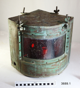 Flagstaff Hill Maritime Museum and Village
Functional object - Navigation Side Lamp, early 20th century
This pair of navigational lamps or lights was fitted to the vessel S.S. Rowitta when it was renovated to become a display passenger ferry at Flagstaff Hill Maritime Village from 1976-2015. Navigation lamps are used to indicate a vessel’s position and direction of travel to other vessels nearby. This system of coloured lamps is standardised throughout the world for all marine vessels, red is for port and green for starboard, (red is for the boats right hand side). These navigation lamps were not the original fittings for this vessel but had come from a similar vessel of the same era of the early 1900’s. The history of the lamp fittings at this time is unknown. SS ROWITTA: - The 1909 steam ferry, SS Rowitta, was installed as an exhibit at Flagstaff Hill in 1975 and was enjoyed by many visitors for 40 years. Rowitta was a timber steam ferry built in Hobart in 1909 using planks of Huon and Karri wood. She was a favourite of sightseeing passengers along Tasmania’s Tamar and Derwent rivers for 30 years. Rowitta was also known as Tarkarri and Sorrento and had worked as a coastal trading vessel between Devonport and Melbourne, and Melbourne Queenscliff and Sorrento. In 1974 Rowitta was purchased by Flagstaff Hilt to convert into a representation of the Speculant, a historic and locally significant sailing ship listed on the Victorian Heritage Database. (The Speculant was built in Scotland in 1895 and traded timber between the United Kingdom and Russia. Warrnambool’s P J McGennan & Co. then bought the vessel to trade pine timber from New Zealand to Victorian ports and cargo to Melbourne. She was the largest ship registered with Warrnambool as her home port, playing a key role in the early 1900s in the Port of Warrnambool. In 1911, on her way to Melbourne, she was wrecked near Cape Otway. None of the nine crew lost their lives.) The promised funds for converting Rowitta into the Speculant were no longer available, so she was restored back to her original configuration. She represented the importance of coastal traders to transport, trade and communication in Australia times before rail and motor vehicles. Sadly, in 2015 the time had come to demolish the Rowitta due to her excessive deterioration and the high cost of on-going repairs. She had given over 100 years of service and pleasure to those who knew her. These lamps are an historical example of navigational equipment used in the early 20th century, adhering to a navigational standard that is worldwide, and a design similar to what is still being used today. They were used on the display vessel at Flagstaff Hill Maritime Village as an aid to maritime education. The Rowitta represents the importance of coastal traders to transport, trade and communication along the coast of Victoria, between states, and in Australia before rail and motor vehicles. The vessel was an example of a ferry built in the early 20th century that served many different roles over its lifetime of over 100 years. Two side navigation ship's lamps, quarter circle shaped metal boxes with glass window and removable lid. The lid attaches to the box using four brackets, wingnuts and screws that swing down out of the way. The window of double-thickness glass is inserted on the curved side of the box and attached by screws around the frame. The inner glass panel is coloured according to the lamp’s use; port is red and starboard green. The port lamp has a round hole cut into each of the two straight sides and an electrical fitting inside. The starboard lamp also has a hole in each straight side (one with a threaded fitting). Its lid has an additional cross bar on top that has a circular space in the centre, nuts and screws fit through holes in the ends and a folding handle is attached across the centre space. The lamps were once fitted onto the vessel Rowitta. The starboard lamp has an inscription stamped into the metal. Impressed on 3689.2; “STARBOARD PATT 8025” flagstaff hill, warrnambool, flagstaff hill maritime museum, maritime museum, flagstaff hill maritime village, navigation lamp, navigation light, navigation equipment, starboard patt 8025, ship’s fitting, rowitta, tarkarri, speculant, purdon & featherstone of hobart, passenger ferry 1909, vessel, display rowitta, display passenger ferry, sorrento -
 Eltham District Historical Society Inc
Photograph, Fay Bridge, Ancient Eel trap on the Yarra River at Laughing Waters, Eltham - pre-dating European settlement, 6 September 2023
Laughing Waters is the name for a stretch of the Yarra Valley Parklands consisting of river flats and hilly riparian bushland. With Birrarung (Yarra River) flowing through, Laughing Waters has been an important gathering place for thousands of years. For the Wurundjeri, ‘Garambi Baan’ (the name for Laughing Waters in Woi wurrung) is an important site for growing and harvesting food. Significantly, Wurundjeri iuk (eel) traps remain at Garambi Baan to this day. The Wurundjeri Woi Wurrung People take their name from the Woi wurrung language word ‘wurun’ meaning the Manna Gum (Eucalyptus viminalis) which is common along ‘Birrarung’ (Yarra River), and ‘djeri’, the grub which is found in or near the tree. Wurundjeri are the ‘Manna Gum People’ and their Ancestors have lived on this land for millennia. The site on the Yarra River near the former Morrison property Killeavey was given a language name in 2015 at the instigation of Wurundjeri Elder, Dave Wandin. Garambi Baan means “laughing waters” in the traditional language, Woi wurrung. The site at Warrandyte was rediscovered by Campbell Beardsell OAM in 2007 and is one of only a few known remaining iuk (eel) traps on Country once found the length of the Birrarung (Yarra) and the Maribyrnong. Original Indigenous aquacultural infrastructure was dismantled, taken away from sites and used to build houses, fords and roads by Europeans. The difficult and restricted access to this site is thought to be one of the reasons for its survival. The iuk trap is located within lands managed by Parks Victoria. The Narrap team in partnership with Parks Victoria and Acacia Land Management have been improving the native vegetation with a program of woody weed removal, exclusion fencing and revegetation. Importantly, the team have restored the trap’s infrastructure and have demonstrated its effectiveness.” References: Wurundjeri Woi Wurrung Cultural Heritage Aboriginal Corporation - Laughing Waters. (2023, September 3). Retrieved from https://inplace.org.au/laughing-waters/ GARAMBI BAAN LAUGHING WATERS RESIDENCY CENTRE 2020 2024 Strategic Plan, Nillumbik Shire Council (2023, September 3). Retrieved from https://www.nillumbik.vic.gov.au/files/assets/public/minutes-and-agendas/2020/09-sep/15-sep-cm/ocm.177-20-attachment-1-laughing-waters-arts-program_1.pdffay bridge collection, eel trap, laughing waters, yarra river, wurundjeri woi wurrung, garambi baan, 2023-09-06 -
 Eltham District Historical Society Inc
Photograph - Digital Photograph, Jim Connor, Edendale Farm Homestead, 11 December 2014
Edendale Farm is Nillumbik Shire Council's environment centre situated in Gastons Road, Eltham between the railway and the Diamond Creek. The homestead on the property was built in 1896 and is of historical significance, being the subject of a Heritage Overlay under the Nillumbik Planning Scheme. The Edendale property was originally part of an extensive land purchase in 1852 from the Crown by pioneer Eltham farmer Henry Stooke. He initially purchased 51 acres and later expanded his holdings by purchasing another three adjacent Crown allotments extending northerly from Josiah Holloway's Little Eltham subdivision. Despite clearing the land, Stooke did not build on this property, choosing to live on his property "Rosehill" at Lower Plenty. In 1896 Thomas Cool, Club Manager of the Victoria Coffee Palace in Melbourne purchased 7 acres of the original Stooke land and built the house now known as Edendale. Cool did not farm the land, instead using it as a gentleman’s residence, retiring to Eltham at weekends. In 1918 he purchased an additional 7 acres but in 1919 he sold the property. Later owners included J.W. Cox, the Gaston family and D. Mummery. In the 1980s the Eltham Shire Council purchased the site for use as a Council depot, but this use did not proceed. Subsequently, it was used as the Council pound. The Edendale Farm Pet Education and Retention Centre was established in the summer of 1988/1989 and was set up to replace the existing dog kennels with a high standard pet retention centre. The design style of the building was established to compliment the features of the existing house. It was equipped with 10 retention pens, a veterinary room and a pet education area where school children and other interested parties learnt about pet care procedures. It was later developed into a community farm and was run by an advisory committee and in 2000 it became an Environment Centre. In early 2006 an advisory committee was established for the development of a master plan for future development at Edendale Farm. The committee included Russell Yeoman, a former long-time shire planner and founding member of the Eltham District Historical Society. At the time of filming the Master Plan and future for Edendale was about continuing to develop Edendale as a centre of environment learning and looking at expanding displays and school program, running a lot more of life-long learning and workshops around sustainable living.jim connor collection, edendale community farm, edendale farm, eltham, gastons road -
 Eltham District Historical Society Inc
Photograph, Fay Bridge, Ancient Eel trap on the Yarra River at Laughing Waters, Eltham - pre-dating European settlement, 16 May 2015
Laughing Waters is the name for a stretch of the Yarra Valley Parklands consisting of river flats and hilly riparian bushland. With Birrarung (Yarra River) flowing through, Laughing Waters has been an important gathering place for thousands of years. For the Wurundjeri, ‘Garambi Baan’ (the name for Laughing Waters in Woi wurrung) is an important site for growing and harvesting food. Significantly, Wurundjeri iuk (eel) traps remain at Garambi Baan to this day. The Wurundjeri Woi Wurrung People take their name from the Woi wurrung language word ‘wurun’ meaning the Manna Gum (Eucalyptus viminalis) which is common along ‘Birrarung’ (Yarra River), and ‘djeri’, the grub which is found in or near the tree. Wurundjeri are the ‘Manna Gum People’ and their Ancestors have lived on this land for millennia. The site on the Yarra River near the former Morrison property Killeavey was given a language name in 2015 at the instigation of Wurundjeri Elder, Dave Wandin. Garambi Baan means “laughing waters” in the traditional language, Woi wurrung. The site at Warrandyte was rediscovered by Campbell Beardsell OAM in 2007 and is one of only a few known remaining iuk (eel) traps on Country once found the length of the Birrarung (Yarra) and the Maribyrnong. Original Indigenous aquacultural infrastructure was dismantled, taken away from sites and used to build houses, fords and roads by Europeans. The difficult and restricted access to this site is thought to be one of the reasons for its survival. The iuk trap is located within lands managed by Parks Victoria. The Narrap team in partnership with Parks Victoria and Acacia Land Management have been improving the native vegetation with a program of woody weed removal, exclusion fencing and revegetation. Importantly, the team have restored the trap’s infrastructure and have demonstrated its effectiveness.” References: Wurundjeri Woi Wurrung Cultural Heritage Aboriginal Corporation - Laughing Waters. (2023, September 3). Retrieved from https://inplace.org.au/laughing-waters/ GARAMBI BAAN LAUGHING WATERS RESIDENCY CENTRE 2020 2024 Strategic Plan, Nillumbik Shire Council (2023, September 3). Retrieved from https://www.nillumbik.vic.gov.au/files/assets/public/minutes-and-agendas/2020/09-sep/15-sep-cm/ocm.177-20-attachment-1-laughing-waters-arts-program_1.pdffay bridge collection, 2015-05-16, eel trap, laughing waters, yarra river, wurundjeri woi wurrung, garambi baan -
 Eltham District Historical Society Inc
Folder, Material pertaining to closure of Eltham RSL Sub-Branch and relocation of Obelisk memorial, 2010-2011
Contents: Minutes of Eltham RSL and Community Meeting held at 29 Nyora Road, Eltham, 23 June 2010 (Community meeting re closure of Eltham RSL sub-branch and relocation of the WW1 Obelisk) Open Letter to the Residents of ELTHAM and MONTMORENCY [And their Surrounding Districts]; 19 March 2012 draft (Invitation to attend the Montomorency Eltham RSL 2012 Anzac Day service at the new site of the Cenotaph in front of the Eltham War Memorial. Includes a brief history of the obelisk and the Eltham War Memorial) Newspaper clipping - Hall 'scruffy' - war vet, Diamond Valley Leader, 17 February 2010, p2 Newspaper clipping - RSL branch has a fight on its hands by Alana Schetzer, Heidelberg & Valley Weekly, 3 August 2010, p7 Newspaper clipping - Locals battle state RSL over building, Diamond Valley Leader, 4 August 2010, p7 Newspaper clipping - New home for cenotaph; Councillors support proposal for relocation to Eltham's War Memorial Hall, Diamond Valley Leader, 12 January 2011 Newspaper clipping - CFA hot for RSL site; MP presses for 'fast-track' purchase, Diamond Valley Leader, 23 february 2011, p1 Newspaper clipping - New home for cenotaph delights war veterans, Diamond Valley Leader, 31 August 2011, p9 Council's Heritage Advisor, Samantha Westbrooke Pty Ltd advised Council in 2014 that the relocation of the cenotaph had compromised the significance of the War Memorial Building Complex as the two memorials, while both commemorating World Wars, demonstrate two very different methods of memorialising. The World War Two War Memorial Building Complex with its civic purpose was a conscious shift away from memorialisation by monuments and a focus on the future and not the past. The cenotaph is an example of the post World War One memorialising practice of erecting monuments to commemorate the past. The location of the cenotaph in front of the former Infant Welfare Centre confuses the history of the site and obscures the ability to view the three buildings as a united complex. Additional subsequent modifications with the provision of access ramps and rails has further impacted upon the garden design. Nine A4 pages printed and six newspaper clippingsalan field, cfa, eltham rsl sub-branch, eltham war memorial hall, eltham war memorial, john cohen, montmorency-eltham rsl sub-branch, obelisk, war memorial garden -
 Federation University Historical Collection
Booklet, Churchill & District Community Association, Churchill's 40th Anniversary, 2005
Green and brown soft covered book of 16 pages.non-fictionchurchill, monash university, hazelwood, yallourn, eel hole, eel hole school, cigar, hare's house, binishell, gippsland, gippsland campus, gippsland campus collection -
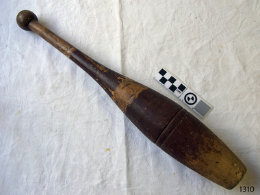 Flagstaff Hill Maritime Museum and Village
Equipment - Juggling Club, late 19th to early 20th century
This wooden juggling club or exercise club may also be referred to as a juggling pin. It is very similar in shape to a bowling pin or an Indian club. It dates approximately to the early 20th century. It may have been used as one of a pair for gymnastics or exercise, or part of a larger set used by a juggler for entertainment in a circus or carnival. At some time it may have been used with a ball or disc as part of a Skittles or bowling game set. The historical collection of Federation University Australia, Victoria, includes a very similar but slightly shorter club, labelled ‘timber skittle”, as can be seen in their photograph. Another example of very similar-shaped, same-sized clubs can be seen in the collection of Nobelius Heritage Park and Emerald Museum, Emerald, Victoria. JUGGLING Jugglers entertain audiences with their tricks and routines at events such as circuses, amusement parks, parties, shows on television or theatre, schools and parties. Juggles also compete at International Championships to obtain world records, performing as individuals or in groups or teams. Contemporary champion juggler David Cain performs a Juggling History Show that both entertains and educates his audience. His routines date from the early 1600s to the 20th century. He uses a wide variety of equipment in his acts including juggling clubs. EXERCISE Exercise clubs or Indian clubs were used in 19th century Victorian times as part of exercise or strengthening programs when they were swung in certain patterns and movements. Even in the early 20th century workplace a few minutes of Indian club swinging was common practice for the relief of tension. A video clip of an American school room in 1904 shows a group of boys and girls skilfully wielding clubs in an exercise sequence (see ‘Links” section). The 1904 and 1932 Olympic Games had an event called Club Swinging. Rhythmic gymnastics was added to the Olympic Program at the L.A. Games in 1984 where competitors use apparatus such as rope, hoop, ball, ribbon and clubs. The clubs come in a variety of weights and heights and have been used from the mid-1800s until around the 1930s in schools and military institutions. They are decorated in a variety of patterns and colours and some have feature lines or scored rings on them. This juggling club is significant for its association with education, entertainment and sport in the late 19th and early 20th century.Wooden juggling club (or pin, skittle or Indian club). Vintage, bottle-shaped club with a flat, slightly concave, base. Its turned, solid timber body tapers out from the base then in again to a very narrow handle with a round knob joined onto the top. Two concentric feature lines are scored into the wider part of club. It was possibly used in exercise, gymnastics or as a skittle. Sections of the club have two brown painted stripes; paint on the lower strip has been worn off at the base . There are remnants of white paint in two areas, possibly the remains of a maker’s name or decoration. There also appears to be an inscription stamped into the wooden handle but this is illegible. Late 19th to early 20th century.Remnants of what appears to be stamped lettering and painted labelling.flagstaff hill, warrnambool, shipwrecked coast, flagstaff hill maritime museum, maritime museum, shipwreck coast, flagstaff hill maritime village, great ocean road, wooden skittle, entertainment, bowling skittle, wooden juggling pin, wooden juggling club, wooden exercise club, indian club, exercise club, club swinging, rhythmic gymnastics, sport equipment, juggling equipment, wooden club -
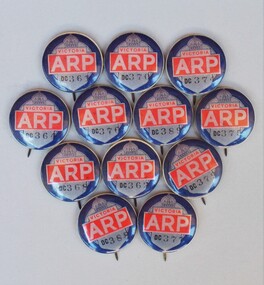 Sunshine and District Historical Society Incorporated
Air Raid Precautions (ARP) badges, Circa early 1940's
Mr Webb King was an Air Raid Warden during World War 2. These badges were found when his workshop was being cleared out, and so were donated to our society. The badges in our possession do not have the word WARDEN printed on them, like the image of the badge shown on the Darebin Heritage 'Air Raid Protection Services (ARP)' publication, or the image of a badge offered for sale on ebay. At this stage we are uncertain of why this is so. If anybody knows the answer then please leave a message on this site. During World War 2 Australian municipalities were expected to take precautions against air raids, with the Government campaigning to recruit men over 45 to be volunteer Air Raid Wardens. It was also common for women to become wardens. Wardens carried gas masks, helmets, and rattles or whistles. The wardens received 7 to 8 one hour sessions of training, and their chief duty was to advise people of precautions to take, and to ensure those precautions were taken. Air Raid Precautions included air raid drills, shelters (usually trenches), first aid, fire fighting, rescue of 'gassed' persons, evacuation drills, demolition and repair squads, monitoring of blackouts. Melbourne was deemed vulnerable to aerial attack because of its centralised port and industrial facilities and so Anti-aircraft guns were installed in Maribyrnong. By early 1942 more than 60,000 people voluntarily carried out Air Raid Precautions duties according to the Autobiography of Robert V. J. Padula OAM. As the threat diminished during 1943 and 1944 the need for air raid precautions was slowly reduced, and some shelters (trenches) were filled. The two photos showing Air Raid Wardens are out of copyright and have been sourced from the 'Argus Newspaper Collection of Photographs, State Library of Victoria.' The image showing one warden on Swanston Street Melbourne has been cropped to remove extras not connected with the photo. Other sources of information for this report are: (1) http://bpadula.tripod.com/autobiography/id100.html, (2) https://www.awm.gov.au/exhibitions/underattack/mobilise/precautions.asp, (3) http://heritage.darebinlibraries.vic.gov.au/article/57. The ARP badges are a historic reminder of the precautions that were taken in Victoria during the early years of World War 2. The precautions were an effort to minimise the harmful effects of a theoretical air raid. The war started to turn and so an air raid never came, however many people received valuable training in what precautions needed to be taken.Pressed metal round badges with pins. Main feature of badges is the large whitish lettering ARP on a red background. A black outlined crown and the word VICTORIA in red on whitish background is also on the badges. At the bottom of the badges in black are the letters DC plus the numbers of the badges.Serial Numbers of the badges are: DC 361, DC 362, DC 364, DC 368, DC 370, DC 374, DC 375, DC 376, DC 377, DC 379, DC 388, DC 389.arp. arp badge, air raid precautions, air raid precautions warden, warden, badges -
 Old Colonists' Association of Ballarat Inc.
Photograph - Image, Ballarat Old Colonists' Association Residence - Williams Cottage, 2016
This home was the first cottage built by the Old Colonists' Association, and was the gift of Mr and Mrs F.J. Williams. It was completed in 1925. From the minute books: "Mr and Mrs F.J. Williams, both natives of Ballarat, offered to build a cottage on the Association's ground at Perry Park [now known as Charles Anderson Grove] something after a style of the Hassell Homes. That offer was immediately followed by another from Mr S.W.J. Clark, a member of the Council. Both offers were promptly and gratefully accepted." One of the first objectives of the Association was "to provide the shelter of a hose for those Pioneers of the Goldfields whom the reverses of fortune have deprived of the means of procuring the comforts of life in their declining years." The first home at Charles Anderson Grove was built in 1925. Before that time the Association provided relief for needy pioneers. Relief included monthly monetary payments, loads of firewood, medical assistance and distribution of Christmas bosed of groceries to deserving pensioners, and in some cases payment of burial costs. ::a) The dominant purpose of the Association is to give public benevolent relief as a charity, but providing independent living accommodation in our Retirement Village for person in need who are over 65. ::b) To raise funds by membership subscription, commercial and residential rents, donations, gifts and voluntary work, for the purpose of providing direct relief of poverty, distress, misfortune or helplessness. ::c) To maintain the important heritage and ongoing viability of the Old Colonists' Association. (Revised Rules of the Old Colonists' Association of Ballarat Inc., 2016) Mr and Mrs Fred John and Matilda Anne Williams of Melbourne made a generous donation to enable this cottage to be built. It was opened in their presence in 1925. Fred John Williams was the son of John Williams and Thomassina Whilley. Together with his brother Frank Williams, Fred Williams was the proprietor of J. Williams and Sons. The brothers took over the business when their father, John Williams, retired in January 1893. In 1918 Fred Williams left Ballarat for Melbourne, at which time he was described as someone who had ‘tried to benefit the whole of Ballarat’. He was highly involved with the Forward Ballarat Movement At the time of his death in February 1926 at Lorne F.J. Williams was a partner in the firm Williams Shoemen Pty. Ltd. Colour photograph of Williams Cottage at The Old Colonists' Association of Ballarat Inc retirement village at Charles Anderson Grove, Ballarat.old colonists' association, ballarat, ballarat old colonists' club, charles anderson grove, f.j. william, retirement village, williams cottage, fred john williams, matilda anne williams, fred williams, matilda williams -
 Old Colonists' Association of Ballarat Inc.
Photograph - Image, Ballarat Old Colonists' Association Residence - Williams Cottage, c1980
This home was the first cottage built by the Old Colonists' Association, and was the gift of Mr and Mrs F.J. Williams. It was completed in 1925. From the minute books: "Mr and Mrs F.J. Williams, both natives of Ballarat, offered to build a cottage on the Association's ground at Perry Park [now known as Charles Anderson Grove] something after a style of the Hassell Homes. That offer was immediately followed by another from Mr S.W.J. Clark, a member of the Council. Both offers were promptly and gratefully accepted." One of the first objectives of the Association was "to provide the shelter of a hose for those Pioneers of the Goldfields whom the reverses of fortune have deprived of the means of procuring the comforts of life in their declining years." The first home at Charles Anderson Grove was built in 1925. Before that time the Association provided relief for needy pioneers. Relief included monthly monetary payments, loads of firewood, medical assistance and distribution of Christmas bosed of groceries to deserving pensioners, and in some cases payment of burial costs. ::a) The dominant purpose of the Association is to give public benevolent relief as a charity, but providing independent living accommodation in our Retirement Village for person in need who are over 65. ::b) To raise funds by membership subscription, commercial and residential rents, donations, gifts and voluntary work, for the purpose of providing direct relief of poverty, distress, misfortune or helplessness. ::c) To maintain the important heritage and ongoing viability of the Old Colonists' Association. (Revised Rules of the Old Colonists' Association of Ballarat Inc., 2016) Mr and Mrs Fred John and Matilda Anne Williams of Melbourne made a generous donation to enable this cottage to be built. It was opened in their presence in 1925. Fred John Williams was the son of John Williams and Thomassina Whilley. Together with his brother Frank Williams, Fred Williams was the proprietor of J. Williams and Sons. The brothers took over the business when their father, John Williams, retired in January 1893. In 1918 Fred Williams left Ballarat for Melbourne, at which time he was described as someone who had ‘tried to benefit the whole of Ballarat’. He was highly involved with the Forward Ballarat Movement At the time of his death in February 1926 at Lorne F.J. Williams was a partner in the firm Williams Shoemen Pty. Ltd. Colour photograph of Williams Cottage at The Old Colonists' Association of Ballarat Inc retirement village at Charles Anderson Grove, Ballarat.old colonists' association, ballarat, ballarat old colonists' club, charles anderson grove, f.j. william, retirement village, williams cottage, fred john williams, matilda anne williams, fred williams, matilda williams -
 Old Colonists' Association of Ballarat Inc.
Photograph - Image, Thornton Richards, Ballarat Old Colonists' Association Residence - Williams Cottage, 28/09/1982
This home was the first cottage built by the Old Colonists' Association, and was the gift of Mr and Mrs F.J. Williams. It was completed in 1925. From the minute books: "Mr and Mrs F.J. Williams, both natives of Ballarat, offered to build a cottage on the Association's ground at Perry Park [now known as Charles Anderson Grove] something after a style of the Hassell Homes. That offer was immediately followed by another from Mr S.W.J. Clark, a member of the Council. Both offers were promptly and gratefully accepted." One of the first objectives of the Association was "to provide the shelter of a hose for those Pioneers of the Goldfields whom the reverses of fortune have deprived of the means of procuring the comforts of life in their declining years." The first home at Charles Anderson Grove was built in 1925. Before that time the Association provided relief for needy pioneers. Relief included monthly monetary payments, loads of firewood, medical assistance and distribution of Christmas bosed of groceries to deserving pensioners, and in some cases payment of burial costs. ::a) The dominant purpose of the Association is to give public benevolent relief as a charity, but providing independent living accommodation in our Retirement Village for person in need who are over 65. ::b) To raise funds by membership subscription, commercial and residential rents, donations, gifts and voluntary work, for the purpose of providing direct relief of poverty, distress, misfortune or helplessness. ::c) To maintain the important heritage and ongoing viability of the Old Colonists' Association. (Revised Rules of the Old Colonists' Association of Ballarat Inc., 2016) Mr and Mrs Fred John and Matilda Anne Williams of Melbourne made a generous donation to enable this cottage to be built. It was opened in their presence in 1925. Fred John Williams was the son of John Williams and Thomassina Whilley. Together with his brother Frank Williams, Fred Williams was the proprietor of J. Williams and Sons. The brothers took over the business when their father, John Williams, retired in January 1893. In 1918 Fred Williams left Ballarat for Melbourne, at which time he was described as someone who had ‘tried to benefit the whole of Ballarat’. He was highly involved with the Forward Ballarat Movement. At the time of his death in February 1926 at Lorne F.J. Williams was a partner in the firm Williams Shoemen Pty. Ltd. Colour photograph of Williams Cottage at The Old Colonists' Association of Ballarat Inc retirement village at Charles Anderson Grove, Ballarat.old colonists' association, ballarat, ballarat old colonists' club, charles anderson grove, f.j. william, retirement village, williams cottage, fred john williams, matilda anne williams, fred williams, matilda williams, williams shoemen pty. ltd -
 Old Colonists' Association of Ballarat Inc.
Photograph - Image, Thornton Richards, Ballarat Old Colonists' Association Residence - Williams Cottage, c1982
This home was the first cottage built by the Old Colonists' Association, and was the gift of Mr and Mrs F.J. Williams. It was completed in 1925. From the minute books: "Mr and Mrs F.J. Williams, both natives of Ballarat, offered to build a cottage on the Association's ground at Perry Park [now known as Charles Anderson Grove] something after a style of the Hassell Homes. That offer was immediately followed by another from Mr S.W.J. Clark, a member of the Council. Both offers were promptly and gratefully accepted." One of the first objectives of the Association was "to provide the shelter of a hose for those Pioneers of the Goldfields whom the reverses of fortune have deprived of the means of procuring the comforts of life in their declining years." The first home at Charles Anderson Grove was built in 1925. Before that time the Association provided relief for needy pioneers. Relief included monthly monetary payments, loads of firewood, medical assistance and distribution of Christmas bosed of groceries to deserving pensioners, and in some cases payment of burial costs. a) The dominant purpose of the Association is to give public benevolent relief as a charity, but providing independent living accommodation in our Retirement Village for person in need who are over 65. b) To raise funds by membership subscription, commercial and residential rents, donations, gifts and voluntary work, for the purpose of providing direct relief of poverty, distress, misfortune or helplessness. c) To maintain the important heritage and ongoing viability of the Old Colonists' Association. (Revised Rules of the Old Colonists' Association of Ballarat Inc., 2016) Mr and Mrs Fred John and Matilda Anne Williams of Melbourne made a generous donation to enable this cottage to be built. It was opened in their presence in 1925. Fred John Williams was the son of John Williams and Thomassina Whilley. Together with his brother Frank Williams, Fred Williams was the proprietor of J. Williams and Sons. The brothers took over the business when their father, John Williams, retired in January 1893. In 1918 Fred Williams left Ballarat for Melbourne, at which time he was described as someone who had ‘tried to benefit the whole of Ballarat’. He was highly involved with the Forward Ballarat Movement. At the time of his death in February 1926 at Lorne F.J. Williams was a partner in the firm Williams Shoemen Pty. Ltd. Colour photograph of Williams Cottage at The Old Colonists' Association of Ballarat Inc retirement village at Charles Anderson Grove, Ballarat. It features a colourful flower border. old colonists' association, ballarat, ballarat old colonists' club, charles anderson grove, f.j. william, retirement village, williams cottage, fred john williams, matilda anne williams, fred williams, matilda williams -
 Parks Victoria - Wilsons Promontory Lightstation
Stretcher
Made of canvas and bamboo slats with hemp ropes, adjustable canvas straps and metal buckles and rings, the rescue stretcher was used for carrying an injured person. According to the Powerhouse Museum, the stretcher and was ‘designed to support and carry an injured person in circumstances where the person has to be lifted vertically’. Known as the ‘Neil Robertson stretcher’, it was developed in the early 1900s by John Neil Robertson as a lightweight rescue device and was modelled on Japanese bamboo litters. An identical stretcher is held in Sydney’s Powerhouse Museum and is thought to date between c.1967 and 1999. The museum’s statement of significance for the unique stretcher elaborates on its cultural values: The canvas is wrapped around the patient and secured with strong canvas straps. A lifting rope is attached to a ring above the patient's head, while a guideline is tied near the ankles and used to stop the stretcher swaying as it is hoisted up. This style of stretcher was specifically designed for use on ships, where casualties might have to be lifted from engine-room spaces, holds and other compartments with access hatches too small for ordinary stretchers. The original name of the Neil Robertson stretcher was 'Hammock for hoisting wounded men from stokeholds and for use in ships whose ash hoists are 2 ft. 6 in. diameter'. Since those times the Neil Robertson stretcher has also been used in factories and mines and for other emergency rescue situations. It is still possible to buy this type of stretcher although the slats are now more likely to be made of wood. The example in the Powerhouse collection was amongst several items of obsolete first aid and rescue equipment donated by the electricity generation company Delta Electricity. It would have been used - or at least been on stand-by - at the company's Munmorah Power Station or the associated coal mine on the Central Coast of New South Wales. Industrial sites and mines are extremely dangerous work places. Throughout the 20th century to the present there has been a drive, especially in developed countries like Australia, to improve workplace safety. Measures taken to reduce injuries and deaths have included safer industrial equipment, safer work practices, staff training, and the ready availability of accident and emergency equipment.It was also used throughout WWI and WWII. There are two other examples of the stretcher are known in Parks Victoria heritage collections. Canvas and bamboo stretcher with straps and buckles. Hemp ropes are attached to the stretcher. -
 Parks Victoria - Cape Nelson Lightstation
Furniture - Cabinet
The cabinet has a curved back and would have been custom‐built to fit the dimensions of the lantern room interior. It is likely to date from when the lighthouse was built in 1884 and may have been among the items delivered by the government steamer dispatch early in March which included ‘the lantern and other fittings for the Cape Nelson Lighthouse’. The Public Works Department provided a range of lightstation furnishings including office desks and cabinets, and domestic settings for keepers’ quarters, with nineteenth century items often stamped with a crown motif and the PWD monogram however the curved cupboards installed in Victoria’s lighthouse lantern rooms do not appear to display this small feature. Further research may reveal more about their manufacture and it is tempting to think that they were perhaps even supplied by Chance Bros as part of the entire lantern room installation. The company usually provided the timber battens for the lantern room paneling, and a cabinet may have been included in the assemblage. Another possibility is that the specially designed cabinet was made on site by carpenters along with other fittings. It is not known whether it is attached to the wall or movable; if attached it is considered to be a fixture and included in the Victorian Heritage Register listing for the lightstation (VHR H1773). Its location, when identified in the CMP of April 1995, was on the ‘lower lantern level’, where there was also a ‘timber step ladder’ (Argus, 6 March 1884, p6. nineteenth or early twentieth century), ‘timber framed lighthouse specification’, ‘timber framed chart’ and telephone .Residue on the furnishing indicates that it was formerly painted green, the colour of some of the other fixtures in the room, such as the original cast iron ladder. It is now partially varnished and the corner to the top’s edging on the right side has been cut off. The lighthouse also has a large curved back, two‐door cupboard. Other similar cabinets with curved backs survive at Cape Schanck, varnished wood cabinet with brass door knob, no drawers; Point Hicks, painted green with silver doors, no drawers and Gabo Island, bench top, 2‐door, no drawers, green paint removed to reveal cedar timber). Cape Nelson’s curved cabinet is unique among these examples for having drawers. The cabinet is a unique, original feature of the lantern room and has first level contributory significance for its historic values and provenance.The bench top cupboard has two drawers, each above a door, and each door is framed and beveled around a central panel. The cabinet has a curved back. -
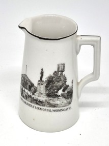 Wodonga & District Historical Society Inc
Souvenir - Souvenir Cream Jug - Soldiers' Memorial, Wodonga
This item is from a collection donated by descendants of John Francis Turner of Wodonga. A wide range of small china pieces carrying scenic views of holiday destinations or key locations were a popular kind of souvenir during much of the 20th century. Several different items have been produced to commemorate Wodonga and its landmarks over time. These items document key changes in Wodonga and its heritage. This plate depicts three key landmarks in Wodonga. THE SOLDIERS' MEMORIAL in Wodonga was unveiled on Tuesday 18th November 1924. It was designed by Messrs. Hosken & Co., of Hawthorn, Victoria. The monument is all of Australian workmanship. The pedestal is made of Harcourt granite, 9ft x 9ft at the base, and rising in seven courses to a height of 10ft 2in. The emblems (rising sun and wreath) are of bronze, and the lettering of the inscription and names of fallen soldiers are in raised lead letters. Originally the Memorial was completed with a full life size, 6ft in height, sculpture of an Australian soldier in Sicilian marble. The memorial bore the inscriptions: ERECTED BY THE RESIDENTS OF WODONGA AND DISTRICT IN MEMORY of the Men of this Town and District who fell in the Great War, 1914-1919, Also in grateful recognition of the men who served and returned. “Lest We Forget.” In 1982, due to frequent vandalism and high cost of materials to repair, the soldier statue was removed and later installed at the RSL Rooms. THE WATER TOWER is a major landmark of High Street, Wodonga. It began operation from January 1924 until it ceased operation in 1959. It stood unused for a decade until the lower section was modified and put to use as “ The Tower’s Cobbler’s Inn” in 1962. In 1972 Wodonga City Council proposed to demolish the Tower. Their suggestion received an unfavorable response from the city’s citizens, so the Tower still stands today. THE BAND ROTUNDA was officially opened on Sunday 5th September 1920 at the naming of the triangular reserve at the corner of High and Hovell Streets as Woodland Grove. The Wodonga Band gave a public performance on this occasion. The tri-coloured ribbon, which stretched across the entrance to the Rotunda was cut by Mrs R.H Murphy, daughter of Mr. John Woodland, secretary of the Wodonga Shire Council for 35 years, after whom the area was named. The rotunda has since been moved to Martin Park, Wodonga.This item comes from a collection used by a prominent citizen of Wodonga. It is also an excellent example of souvenir items created featuring landmarks to represent the city of Wodonga.White glazed porcelain cream jug with grooved square handle. The base is unglazed. The rim and outer face of the handle are outlined in black paint. On one side of the jug is a black transfer print of a the Wodonga Soldiers' Memorial. Text underneath the scene reads "THE SOLDIERS' MEMORIAL, WODONGA, VIC."'. The manufacturer's trademark is printed on the base of the jug. RKG stood for Rudolf Kampf of Grunlas. The mark with the initials under the crown was used from 1921 to 1938.Beneath the image: 'THE SOLDIERS' MEMORIAL WODONGA VIC" Under the jug Manufacturer's trademark printed in orange paint, in a circular formation '(crown) / RK / G' ('RK / G' within circle with handles) above the words "Made in Czechoslovakia"domestic items, souvenir wodonga, woodland grove wodonga -
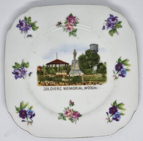 Wodonga & District Historical Society Inc
Souvenir - China Souvenir Plate Soldiers' Memorial. Wodonga, Victoria China, c1924 - 1939
This item is from a collection donated by descendants of John Francis Turner of Wodonga. A wide range of small china pieces carrying scenic views of holiday destinations or key locations were a popular kind of souvenir during much of the 20th century. Several different items have been produced to commemorate Wodonga and its landmarks over time. These items document key changes in Wodonga and its heritage. This plate depicts three key landmarks in Wodonga. THE SOLDIERS' MEMORIAL in Wodonga was unveiled on Tuesday 18th November 1924. It was designed by Messrs. Hosken & Co., of Hawthorn, Victoria. The monument is all of Australian workmanship. The pedestal is made of Harcourt granite, 9ft x 9ft at the base, and rising in seven courses to a height of 10ft 2in. The emblems (rising sun and wreath) are of bronze, and the lettering of the inscription and names of fallen soldiers are in raised lead letters. Originally the Memorial was completed with a full life size, 6ft in height, sculpture of an Australian soldier in Sicilian marble. The memorial bore the inscriptions: ERECTED BY THE RESIDENTS OF WODONGA AND DISTRICT IN MEMORY of the Men of this Town and District who fell in the Great War, 1914-1919, Also in grateful recognition of the men who served and returned. “Lest We Forget.” In 1982, due to frequent vandalism and high cost of materials to repair, the soldier statue was removed and later installed at the RSL Rooms. THE WATER TOWER is a major landmark of High Street, Wodonga. It began operation from January 1924 until it ceased operation in 1959. It stood unused for a decade until the lower section was modified and put to use as “ The Tower’s Cobbler’s Inn” in 1962. In 1972 Wodonga City Council proposed to demolish the Tower. Their suggestion received an unfavorable response from the city’s citizens, so the Tower still stands today. THE BAND ROTUNDA was officially opened on Sunday 5th September 1920 at the naming of the triangular reserve at the corner of High and Hovell Streets as Woodland Grove. The Wodonga Band gave a public performance on this occasion. The tri-coloured ribbon, which stretched across the entrance to the Rotunda was cut by Mrs R.H Murphy, daughter of Mr. John Woodland, secretary of the Wodonga Shire Council for 35 years, after whom the area was named. The rotunda has since been moved to Martin Park, Wodonga.This item comes from a collection used by a prominent citizen of Wodonga. It is also an excellent example of souvenir items created featuring landmarks to represent the city of Wodonga.A china plate depicting the Soldiers' Memorial Wodonga. The central coloured image is surrounded by a 8 representations of a variety of flowers and a silver edge trim. The makers mark underneath the dish was used between 1918 - 1939 so assists in establishing provenance of the irem.Beneath image: "SOLDIERS' MEMORIAL WODONGA On back of dish, Beneath a crown " VICTORIA CHINA CZECHOSLAVAKIA"victoria china, souvenir wodonga, wodonga soldiers memorial, woodland grove wodonga -
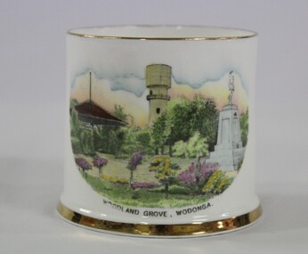 Wodonga & District Historical Society Inc
Memorabilia - China Souvenir Cup Woodland Grove Wodonga, c. 1925 - 1940
A wide range of small china pieces carrying scenic views of holiday destinations or key locations were a popular kind of souvenir during much of the 20th century. Several different items have been produced to commemorate Wodonga and its landmarks over time. These items document key changes in Wodonga and its heritage. This cup depicts three key landmarks in Wodonga. THE SOLDIERS' MEMORIAL in Wodonga was unveiled on Tuesday 18th November 1924. It was designed by Messrs. Hosken & Co., of Hawthorn, Victoria. The monument is all of Australian workmanship. The pedestal is made of Harcourt granite, 9ft x 9ft at the base, and rising in seven courses to a height of 10ft 2in. The emblems (rising sun and wreath) are of bronze, and the lettering of the inscription and names of fallen soldiers are in raised lead letters. Originally the Memorial was completed with a full life size, 6ft in height, sculpture of an Australian soldier in Sicilian marble. The memorial bore the inscriptions: ERECTED BY THE RESIDENTS OF WODONGA AND DISTRICT IN MEMORY of the Men of this Town and District who fell in the Great War, 1914-1919, Also in grateful recognition of the men who served and returned. “Lest We Forget.” In 1982, due to frequent vandalism and high cost of materials to repair, the soldier statue was removed and later installed at the RSL Rooms. THE WATER TOWER is a major landmark of High Street, Wodonga. It began operation from 1924 until it ceased operation in 1959. It stood unused for a decade until the lower section was modified and put to use as “ The Tower’s Cobbler’s Inn” in 1962. In 1972 Wodonga City Council proposed to demolish the Tower. Their suggestion received an unfavorable response from the city’s citizens, so the Tower still stands today. THE BAND ROTUNDA was officially opened on Sunday 5th September 1920 at the naming of the triangular reserve at the corner of High and Hovell Streets as Woodland Grove. The Wodonga Band gave a public performance on this occasion. The tri-coloured ribbon, which stretched across the entrance to the Rotunda was cut by Mrs R.H Murphy, daughter of Mr. John Woodland, secretary of the Wodonga Shire Council for 35 years, after whom the area was named. The rotunda has since been moved to Martin Park, Wodonga. This item has local historic and social significance as it depicts which features of the city the community valued in the past. It has artistic significance as an example of the kinds of souvenirs used widely across Australia to represent communities and the landscape.A white souvenir cup made from china with a water colour image of Woodland Grove, Wodonga which incorporates the Soldier Memorial, Water Tower and the Rotunda."WOODLAND GROVE, WODONGA."souvenirs, wodonga, woodland grove, soldiers memorial, wodonga landmarks -
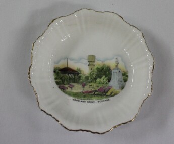 Wodonga & District Historical Society Inc
Memorabilia - China Souvenir Bowl Woodland Grove Wodonga, c. 1920 - 1940
A wide range of small china pieces carrying scenic views of holiday destinations or key locations were a popular kind of souvenir during much of the 20th century. Several different items have been produced to commemorate Wodonga and its landmarks over time. These items document key changes in Wodonga and its heritage. This plate depicts three key landmarks in Wodonga. THE SOLDIERS' MEMORIAL in Wodonga was unveiled on Tuesday 18th November 1924. It was designed by Messrs. Hosken & Co., of Hawthorn, Victoria. The monument is all of Australian workmanship. The pedestal is made of Harcourt granite, 9ft x 9ft at the base, and rising in seven courses to a height of 10ft 2in. The emblems (rising sun and wreath) are of bronze, and the lettering of the inscription and names of fallen soldiers are in raised lead letters. Originally the Memorial was completed with a full life size, 6ft in height, sculpture of an Australian soldier in Sicilian marble. The memorial bore the inscriptions: ERECTED BY THE RESIDENTS OF WODONGA AND DISTRICT IN MEMORY of the Men of this Town and District who fell in the Great War, 1914-1919, Also in grateful recognition of the men who served and returned. “Lest We Forget.” In 1982, due to frequent vandalism and high cost of materials to repair, the soldier statue was removed and later installed at the RSL Rooms. THE WATER TOWER is a major landmark of High Street, Wodonga. It began operation from 1924 until it ceased operation in 1959. It stood unused for a decade until the lower section was modified and put to use as “ The Tower’s Cobbler’s Inn” in 1962. In 1972 Wodonga City Council proposed to demolish the Tower. Their suggestion received an unfavorable response from the city’s citizens, so the Tower still stands today. THE BAND ROTUNDA was officially opened on Sunday 5th September 1920 at the naming of the triangular reserve at the corner of High and Hovell Streets as Woodland Grove. The Wodonga Band gave a public performance on this occasion. The tri-coloured ribbon, which stretched across the entrance to the Rotunda was cut by Mrs R.H Murphy, daughter of Mr. John Woodland, secretary of the Wodonga Shire Council for 35 years, after whom the area was named. The rotunda has since been moved to Martin Park, Wodonga. This item has local historic and social significance as it depicts which features of the city the community valued in the past. It has artistic significance as an example of the kinds of souvenirs used widely across Australia to represent communities and the landscape.A white glazed china souvenir bowl. Frilled edge. Includes a painted representation of Woodland Grove, Wodonga, VictoriaBeneath the painted central image "WOODLAND GROVE, WODONGAwodonga, souvenirs, woodland grove, ceramics -
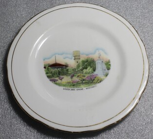 Wodonga & District Historical Society Inc
Memorabilia - Souvenir Plate Woodland Grove, Wodonga, Victoria, Royal Stafford China
A wide range of small china pieces carrying scenic views of holiday destinations or key locations were a popular kind of souvenir during much of the 20th century. Several different items have been produced to commemorate Wodonga and its landmarks over time. These items document key changes in Wodonga and its heritage. This plate depicts three key landmarks in Wodonga. THE SOLDIERS' MEMORIAL in Wodonga was unveiled on Tuesday 18th November 1924. It was designed by Messrs. Hosken & Co., of Hawthorn, Victoria. The monument is all of Australian workmanship. The pedestal is made of Harcourt granite, 9ft x 9ft at the base, and rising in seven courses to a height of 10ft 2in. The emblems (rising sun and wreath) are of bronze, and the lettering of the inscription and names of fallen soldiers are in raised lead letters. Originally the Memorial was completed with a full life size, 6ft in height, sculpture of an Australian soldier in Sicilian marble. The memorial bore the inscriptions: ERECTED BY THE RESIDENTS OF WODONGA AND DISTRICT IN MEMORY of the Men of this Town and District who fell in the Great War, 1914-1919, Also in grateful recognition of the men who served and returned. “Lest We Forget.” In 1982, due to frequent vandalism and high cost of materials to repair, the soldier statue was removed and later installed at the RSL Rooms. THE WATER TOWER is a major landmark of High Street, Wodonga. It began operation from 1924 until it ceased operation in 1959. It stood unused for a decade until the lower section was modified and put to use as “ The Tower’s Cobbler’s Inn” in 1962. In 1972 Wodonga City Council proposed to demolish the Tower. Their suggestion received an unfavorable response from the city’s citizens, so the Tower still stands today. THE BAND ROTUNDA was officially opened on Sunday 5th September 1920 at the naming of the triangular reserve at the corner of High and Hovell Streets as Woodland Grove. The Wodonga Band gave a public performance on this occasion. The tri-coloured ribbon, which stretched across the entrance to the Rotunda was cut by Mrs R.H Murphy, daughter of Mr. John Woodland, secretary of the Wodonga Shire Council for 35 years, after whom the area was named. The rotunda has since been moved to Martin Park, Wodonga. This bone china plate features an image of Woodland Grove. Wodonga, Victoria. The image incorporates landmarks in Woodland Grove, including the Soldiers' Memorial, the Rotunda and the Water Tower. There is a makers' mark imprinted on the underside of the plate."ROYAL STAFFORD/BONE CHINA/ MADE IN ENGLAND/ 423" . A crown is in the centre of the textmemorabilia, woodland grove, wodonga victoria -
 Eltham District Historical Society Inc
Document - Property Binder, 931 Main Road, Eltham
Present day location of Nongkhai Thai Eltham restaurant Formerly the location of: Luther Haleys Bakery and General Store (Sep 1902-1917) - Hayley built this store, which was the first store erected in the present-day Eltham shopping district Hannah Lloyd's General Store (1917-c.Feb 1920) Various owners Staff's General Store (c.1939-Feb 1965) then demolished Ray Staff Eltham Big Star Food Centre (c.1965-1967) Eltham Big Star Food Centre (Staffs new building c.1965-1967) A Country Heritage Furniture and Homewares (?-2006) Newspaper advertisement: Leader Associated Newspapers, 100 Years of News Special Edition, August 27, 1997, p6; A Country Heritage Newspaper advertisement: Diamond Valley Leader, 4 September 2006, Closing Down Sale, A Country Heritage In February 1965, Staffs Railway Store, the oldest business premises in the Eltham shopping district was demolished. Formerly a self-service grocery, restaurant and electrical repair shop, the building for many years housed Eltham’s only ‘family’ grocer and feed store. Earlier it had appeared to have been the town’s bakery. The building had been purchased in late March 1939 by Mr Eric N. Staff. At the time of E.N. Staff’s purchase there were huge bakers’ ovens located at the rear and the building also had a well and four toilets for employees. When the ‘pictures’ came to Eltham with the opening of the Eltham Public Hall across the road in 1941, Mr E.N. Staff extended the business and opened a milk bar and sweet shop. Further extensions re-established the tea rooms of days gone by. Mr E.N. Staff conducted business for about 15 years before handing over the reins to his son, Ray Staff. When his son Ray took over, the milk bar and tea rooms were closed for several years but the milk bar and was later re-opened and subsequently became a greengrocers and later again, a restaurant. The tea rooms section was converted to an electrical repair shop about 1955. Electoral Roll records for 1967 record Raymond Charles Staff at 929 Main Road, Eltham, grocer, and in 1968 at Lot 4, Hillcrest Avenue, Eltham, taxi truck operator. Staff’s store appears to have occupied 929-933 Main Road and the Eltham Big Star Food Centre was centred around 931 Main Road. It would appear that Ray continued to run the business for approximately two years after the original store was demolished and a new supermarket was built. Today, 931 Main Road is the Nongkhai Thai Restaurant and is precisely where the original Staffs store stood. Even though the facade has been modified at eye level with new larger windows, the upper facade is identical to that of the new Eltham Big Star Food Centre of 1965/66. But how did the original building, the oldest premises in the 1965 era shopping centre come about? On August 12th, 1902 at the Eltham Courthouse, appearing before T. Smallman, Esq,. Police Magistrate, and Messrs. W. Duncan and W.J. Taylor, Justices of the Peace is Luther Haley, baker. Wilfred Henry Johnston, by his agent Stanley Ernest Elder had applied for a warrant of ejectment under the Landlord and Tenant Act 1890 against Luther Haley from the bakery premises at the corner of Main Road and York Street. From the evidence presented we learn that Mrs Burgoyne of Eltham had purchased the property some months earlier from Mr Johnston, which consisted of a store and bakery establishment at Eltham occupied by Mr. Luther Haley, and whose lease expired some little time back, and up to the present time, Mr. Haley was not prepared to leave. He informed the court that he is unable to secure at Eltham a suitable house in which to carry on his business, but was building a place near the railway station which he expected to be done in about three weeks time, and he is then prepared to give up possession of the premises he now occupies. Mr Smallman informed the defendant, Luther Haley, that he will have to quit the premises in three weeks from the present date, and that a warrant of ejectment would be issued. However he also informed Mr Haley that he would order the warrant to lie in the office for three weeks from that date. The premises under construction referred to by Luther Haley in court were situated on the western side of Main Road, near the railway station slightly opposite present-day Arthur Street. It was opened around September 1902 as a General Store, Bakery and Tea Rooms. This was the original building in the present-day shopping precinct. At the time the only thing nearby was the railway station. Luther Haley’s business appeared to prosper and he would have catered to not only the locals abut also day visitors by train on Sundays coming up from Melbourne, offering fresh baked produce, tea rooms and summer drinks. The fields across Main Road running between present day Arthur Street and Luck Street were known as Haley’s Paddock and at times were used for community festivities and picnics. A newspaper report on the annual State schools picnic held at Haley’s Paddock on March 11, 1904 described it as “quite close to the railway station, and is quite capable of holding comfortably 10,000 people. With its ample shade and hilly surroundings, it is an ideal place for any gathering.” Luther Haley successfully ran his general store, bakery and tea rooms until 1917 when he and his family departed the district and moved to Westgarth Street in Northcote where he changed careers and became a publisher. It was then taken over by Hannah Lloyd and became known as Lloyd’s Railway General Store from 1917 to 1920. From then it had a succession of owners, one as short as two months until March 31, 1939 when the Grocery Business formerly carried on by Mr. T.K. White of Eltham for the previous eight years was purchased by Mr Eric N. Staff of Research and became known as E.N. Staff’s Railway Store. The ownership timeline for the store is as follows: Luther Haley Sep 1902-1917 Hannah Lloyd 1917-c.Feb 1920 Messrs J.R. & N.E. Lee 1920-Sep 1922 A. & E. Copeland Sep 1922-Sep 1925 Mr Price Sep 1925-Nov 1925 Mr Warren Nov 1925?-Nov 1926 A.W.J. Edwards Nov 1926-1931 T.K. White 1931-Mar 1939 Eric Staff Apr 1939-c.1954 Ray Staff c.1954-Feb 1965 then demolished Ray Staff Eltham Big Star Food Centre c.1965-1967 THROWBACKTHURSDAY: ELTHAM BIG STAR FOOD CENTRE, MAIN ROAD, 1966 https://elthamhistory.wordpress.com/2020/04/16/throwbackthursday-eltham-big-star-food-centre-main-road-1966/eltham, businesses, a country heritage, property, shops, main road eltham, a. copeland, a.w.j. edwards, big star food centre, e. copeland, eric staff, general store, hannah lloyd, j.r. lee, lloyd's general store, luther haley, n.e. lee, price, ray staff, staffs general store, supermarket, t.k. white -
 Eltham District Historical Society Inc
Photograph - Digital Photograph, Marguerite Marshall, Wingrove Cottage, Main Road, Eltham, 8 June 2006
Wingrove Cottage built 1858-1859 of hand made bricks is historically significant for its long association with Charles Wingrove, a prominent figure in Victorian local government, as secretary to the Eltham District Road Board and Shire Council from 1858 to 1904, and Shire Engineer and Secretary to the Heidelberg Road Board. The cottage was used as the office of the Eltham District Road Board and Council for many years It is one of the Shire's oldest dwellings, and one of the few surviving 19th century buildings associated with early Eltham and located in the original Eltham Village Reserve. The symmetrical planting of a pair of Pencil Pines (not visible in photo) is also historically and aesthetically significant as characteristic of the early period of planting in the district and because they are a distinctive landscape feature. In October 2002 new owners demolished the outbuildings attached to the rear of the cottage. Community protest at the demolition resulted in Council issuing a Stop Work order. The owner was issued with a court order in September 2003 to develop a conservation management plan and restore the heritage listed property. The owner sold the property in 2005 to Cameron Construction in 2005 who undertook the restoration work. In 2007 a planning application to build two offices and seven dwellings at the rear of the property was ultimately rejected. The cottage is now the main office for Cameron Construction. Covered under Heritage Overlay, Nillumbik Planning Scheme. Published: Nillumbik Now and Then / Marguerite Marshall 2008; photographs Alan King with Marguerite Marshall.; p57 Wingrove Cottage on Main Road beside Eltham Primary School, is one of the Shire’s most important historical buildings and was central to local government for almost 50 years. The cottage was built in stages from 1858 to 1888 for Charles Symons Wingrove JP. He was the Eltham District Road Board’s first paid secretary and later the Shire Secretary when the board became the Eltham Shire Council. Wingrove held those positions, and that of engineer for a time, for 46 years. He was also one of the main figures in the Municipal Association of Victoria. As Eltham’s first paid municipal officer, Wingrove used one room in his 11 – (originally two) roomed home, as the office for the board then the council. Meetings were held there from the late 1850s (as well as at more central locations) until Wingrove’s retirement in 1904. The cottage is a rare example of a local government office occupying a Road Board /Shire Secretary’s purpose-designed house. The cottage is also significant because it is the oldest largely intact building from the original Eltham township reserve (south of Dalton Street).1 The township had its origins in the 1848 Nillumbik Parish Plan and was one of the state’s earliest township reserves. The rectangular house of handmade bricks, roofed with grey slate tiles and with a veranda encompassing three sides, is reminiscent of those in the central goldfields including Castlemaine. Its overhanging eaves and gables were unlike houses in Melbourne at the time. Wingrove, who was born in 1827, had been a gold digger and a road surveyor. Impossible to imagine in today’s world, Wingrove was also the Shire of Heidelberg’s secretary and engineer for part of the time that he was secretary in Eltham. Living next door to the primary school was a mixed blessing. Wingrove and his wife Katherine, who had ten children, sent their eight surviving children to the school. But they had occasional disputes with the school authorities when their cattle wandered into the schoolyard. Eltham showed Charles Wingrove its appreciation of his services by giving him two illuminated addresses, one after ten years and the other at retirement. Wingrove died in 1905 aged 76 and was buried in the St Katherine’s Church of England cemetery in St Helena. His grave is surrounded by those of family members including his wife, Katherine and two babies, Henry, 12 months and Isobella, 15 months, who died in the mid-1860s. Cottage ownership passed to his wife, then to daughter Caroline and then to daughter Bessie, a Melbourne University graduate and artist. During the Great Depression their brother Walter was the ratepayer. At one stage the Wingrove property extended to Metery Road and included a small creek. The family ran a small dairy and orchard, with associated farm buildings, which were later removed. In 1949 part of the property was compulsorily acquired by the Eltham Primary School, which infuriated owner Bessie Wingrove. She protested in a letter about this ‘monstrous act of unmitigated tyranny’.2 She was the last Wingrove to occupy the cottage and died in 1955. Wingrove descendants sold the house in 1974 and the property was subdivided. In the 1960s the Eltham Shire named the park opposite the cottage in Wingrove’s honour. The cottage has since had several owners including psychiatrist Dr Daniel Kahans, who practised there. In October 2002 late rear additions which had been substantially altered were demolished contrary to council planning controls. This caused a community outcry and resulted in legal proceedings against the owner. Fortunately the historical significance of the demolished section was not as great as the older front part of the building, which has been retained and was later restored.This collection of almost 130 photos about places and people within the Shire of Nillumbik, an urban and rural municipality in Melbourne's north, contributes to an understanding of the history of the Shire. Published in 2008 immediately prior to the Black Saturday bushfires of February 7, 2009, it documents sites that were impacted, and in some cases destroyed by the fires. It includes photographs taken especially for the publication, creating a unique time capsule representing the Shire in the early 21st century. It remains the most recent comprehenesive publication devoted to the Shire's history connecting local residents to the past. nillumbik now and then (marshall-king) collection, cameron construction, charles symons wingrove, eltham, eltham road district board, eltham shire council, main road, wingrove cottage