Showing 10952 items matching " land"
-
 Whitehorse Historical Society Inc.
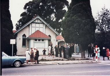
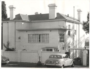
Photograph, Methodist Church, Mitcham, 26/02/1967 12:00:00 AM
Coloured photo of Methodist Church, Mitcham Road, Mitcham. Original street number 115-117, now 339. Service station presently occupies this site. Newer church hall on southern side - land previously occupied by church tennis court. Two medical practices located nearby - Dr. Liebert directly adjacent to left -taken up by Dr. Carter and Dr. Cochrane three houses to right- taken over by Drs. Threlkeld and Twiddy. Both practices now absorbed by 'progress'.methodist church, mitcham. -
 Whitehorse Historical Society Inc.
Newspaper - Article, 5 Longland Road, Heatherdale, 22/02/1984
Article in Nunawading Gazette re sale of 100 year old home at 5 Longland Road, Heatherdale. Double brick Victorian on bluestone foundations. Originally land was owned by Mr Witt who later became an M.P., later a master butcher. Mr Purches built the bluestone foundations. It was planned to have a village nearby to be called New Brunswick between Emery's Hill (now Mitcham) and what is now Ringwood. The only evidence of the once planned village is the existence of Brunswick Road nearby.longland road, mitcham, witt, william, purches (mr), brunswick road, mitcham, heatherdale, mitcham, emery's hill, real estate, auctions -
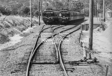
 Ballarat Tramway Museum
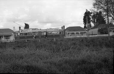
Photograph - B&W print of donated negative, 29/10/1962 12:00:00 AM
Black and white print of a donated negative. Print made 8/1998. Photo of SEC tram No. 40 in Barkly St., Ballarat, Mt. Pleasant line. Side on view of the tram going up a slight hill, looking across a vacant block of land. Photo taken 29-10-1962. Ron Fluck collection. Has "Eureka Roofing Tiles" and SEC "Electricity Best for Cooking" advertisements on the roof of the tram. High Res scan of negative added 17/1/2019.tramways, trams, mt pleasant, barkly st., ballarat, 40, tram 40 -
 Ballarat Tramway Museum
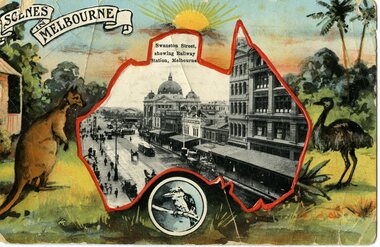
Postcard, Swanston St Melbourne, showing Flinders St station, 1913
Yields information about Swanston St Melbourne and demonstrates German printed colour photo postcards.Black and white view of Swanston St Melbourne, showing Flinders St station, with cable trams, located within a map of main land Australia, with a colour printed background containing a kangaroo, emu and kookaburra. Title "Scenes in Melbourne". On rear of card "Printed in Saxony" Has been sent by a person on the RMS Medina, from Sydney, 29/10/1913 to Miss M Fenton at the "All Nations Hotel", Port Melbourne. Has an Australian 1d one penny stamp.Written on reartrams, tramways, postcards, melbourne, swanston st -
 Bendigo Historical Society Inc.
Magazine - Magazines from 1930s
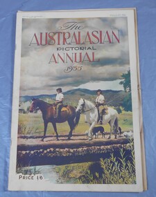
Assorted magazines: The Star from February 1, 1936. The Australian from March 16, 1935 - March 30. 1935 - April 20, 1935 - May 4, 1935 - August 3, 1935 - January 11, 1936. The Australasian pictorial annual 1934 and 1935. The Land farm & station annual, August 23, 1939. The Illustrated London News from December 22, 1934. The Australasian annual 1949/1950. The Sun tree book. These magazines are part of the Aileen and John Ellison collection. national magazines, world magazines -
 Kew Historical Society Inc
Photograph, 'Yarra Bluff', Redmond Street, c.1965
This work forms part of the collection assembled by the historian Dorothy Rogers, that was donated to the Kew Historical Society by her son John Rogers in 2015. The manuscripts, photographs, maps, and documents were sourced by her from both family and local collections or produced as references for her print publications. Many were directly used by Rogers in writing ‘Lovely Old Homes of Kew’ (1961) and 'A History of Kew' (1973), or the numerous articles on local history that she produced for suburban newspapers. Most of the photographs in the collection include detailed annotations in her hand. The Rogers Collection provides a comprehensive insight into the working habits of a historian in the 1960s and 1970s. Together it forms the largest privately-donated collection within the archives of the Kew Historical Society.'Yarra Bluffs' was the home of George Henry (1831-1906) and Allegra Charnock Mott (1831-1905), newspaper proprietor (and also a friend of John Inglis, father of Kew doctor, Edgar Inglis, who bought land adjacent to this property in the 1890s). Walter was a son who drowned in the Yarra in a swimming accident January 2, 1890. George & Allegra had fourteen children and the family continued newspaper publishing interests from 1853 until 1986, over four generations.' (Andrew Mott, 2015)[Annotation on reverse by Dorothy Rogers] "Walter Mott's house - formerly Yarra Bluff, Redmond St Kew. This was formerly the back entrance. It is now 2 flats. The upper is occupied by the present owner Mr. Tyler. Walter was drowned in the Yarra. He built the house about ____. He commenced the Kew Mercury in 188_. Back view of George Motts home (1890) Redmond Street".walter mott, yarra bluff, studley park, dorothy rogers -
 University of Melbourne, Burnley Campus Archives
Album - 35mm Colour slides, Garden Views and Miscellaneous, 1960-1964
18 slides 1960-1964. 1. "Pep Talk" Feb 1960 (Wilson's Promontory?) 2. "Undeveloped land (mowed) Ryde S of H 17.3.61". 3. "Burnley Hort College Feb 1962". 4. "BHC Vege Ground 1963", 5. "Cow Paddock New Plantings. 4, 6, 15, 16, 19. Orchard 1963". 3, 7-11, 13, 14. Garden views Sep 63. 17, 18. "Second Year Students 1964-Mildura".burnley horticultural college, cow paddock, plantings, garden views, students, bhc, lagoon paddock, vegetable plots, mildura camp, orchard, wilson's promontory -
 Wodonga & District Historical Society Inc
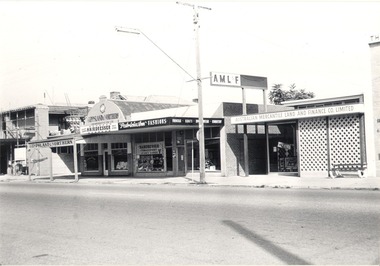
Photograph - Mann Collection Album - Terminus Hotel; Gippsland & Northern
This photo is part of a collection of Wodonga Town Photos donated by Elaine Mann. Elaine was married to David Mann, a successful Wodonga businessman and community leader who passed away in Wodonga in June 2012. David was a member of the Mann family who began their business in Wodonga in 1920. Elaine was a teacher in Wodonga for many years and an active member of the community. The Terminus Hotel In 1873, James Thompson Hatch built the two-storeyed Terminus Hotel at 79 Sydney Road (later known as High Street), then sold it to George Day and Kenneth McLennan for £1,230. It was first licensed to J. G. Morton in January 1874. In 1879, Annie Allen, from Ireland, took over as licensee of the hotel containing 14 rooms, after she and her husband, George James Allen, purchased it. He became licensee in 1883. Under the Allens, the Terminus became, ‘a principal rendezvous for visitors to the town.’ September 1888 saw additions to the building that included a billiard room, a dining room, and 18 other rooms. Following the death of her husband in 1889, Annie Allen continued to run the Terminus Hotel. She later married John Haldon and was licensee of the hotel until 1893 when the licence was transferred to William Carkeek. In the early 1900s the Hotel was thoroughly renovated. The Terminus Hotel was for sale by auction on 5th March 1909. It comprised about 50 rooms, a two-storey building built of brick and iron with hot and cold water service and acetylene gas throughout. The principal hotel in Wodonga, was let from 1st January 1909 on a seven years’ lease at a rental of £9 per week. 1935 saw extensive improvements by proprietor W. P. Kinney, while in 1941 further extensive improvements were carried out to make a good hotel better. A pall of shock and disbelief descended over Wodonga’s historic Terminus Hotel on 1st June 1998 when it was destroyed by fire then demolished in 1999. The site was sold for almost $1 million and redeveloped for a medical clinic.This photo collection is of significance as it documents how the businesses and buildings in Wodonga have evolved and contributed to community throughout the late 20th century.Terminus Hotel; Gippsland & Northern Co-operative Pty. Ltd.; Graham Bradbury Men's Hairdresser; Patricia Anne Fashions; Australian Mercantile Land and Finance Company (A.M.L. & F). on the west side of High Street. The Terminus Hotel was built C. 1873. and was destroyed by fire in 1998, The Gippsland and Northern Co-operative Co. Ltd was formed in 1905, but the date of its establishment in Wodonga is not confirmed, but they were holding fortnightly sales at the Wodonga sale yards by early 1919.wodonga businesses, high st wodonga, terminus hotel, gippsland & northern -
 Bendigo Historical Society Inc.
Document - LANDS OFFICE - CROWN LANDS SURVEYED AND SOLD SANDHURST, 1860 onwards
Journal: LANDS OFFICE - CROWN LANDS SURVEYED AND SOLD SANDHURST green hard cover journal with buff spine and corners. Contains details of crown land surveyed and sold in the district of Sandhurst. Indexed in front by parish, alphabetical double pages not numbered. On LH page, parish, town, suburban, country, date of survey. On RH page, date of sale, auction, selection, price, total amount, purchaser. On spine ' index book' 'F' and '09'. Dated from 1860 onwardsLands Officeland sales, bendigo -
 Bendigo Historical Society Inc.
Document - LANDS OFFICE, CROWN LANDS SURVEYED AND SOLD, 1860/70
Document: buff hard cover journal, embossed on borders. On spine 'Lands and Survey' 'Index Book' and '03'. Contains list of parishes in front cover, indexed to page numbers which describes land surveyed and sold in parishes. Double page entries. 230 pages in book. LH page ' town lands, suburban lands, country lands, total lands surveyed, date of survey. RH page: date of sale, by auction, by selection, price per acre, total amount name of purchaser.Lands Officeland sales, lands office, land surveyed, land sold, bendigo, sandhurst -
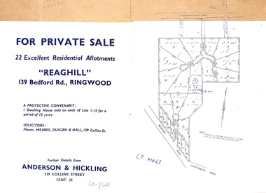 Ringwood and District Historical Society
Document - Folder, Reaghill Estate Subdivision, Ringwood, Victoria - circa 1958
Bifold land sale brochure glued to brown stationery folder with advertisement including map of original subdivision (circa 1958) and subsequent 1982 re-subdivision of Lot 7 Vista Avenue - LP41463 - Part of Crown Allotment 43, Parish of Ringwood, and 4-page brochure for sale of 4 luxury new homes built by Bovis Homes Aust. P/L as presented by Lyndsay Edmonds Homes. Subdivision includes Bedford Road, Homebush Court, Vista Avenue and Vista Court. Original protective covenant: "One dwelling house only on each of Lots 1-15 for a period of 15 years". Agent - Anderson & Hickling, 239 Collins Street, Melbourne. (Phone) Cent.25. -
 Bendigo Historical Society Inc.
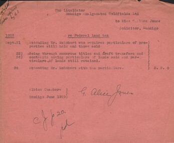
Document - MISS G ALICE JONES COLLECTION: ACCOUNT
The Liquidator Bendigo Amalgamated Goldfields Ltd to Miss G. Alice Jones. Re Federal Land Tax. Pink paper dated. 21, 22, 24, 26 1928 and June 1929. Account includes particulars of properties still held and those sold, going through titles and draft transfers and contracts noting particulars of lands sold and of lands still held. Cost £2.2.0. "R492 Posted 29/6/1929 by B.F?" written in the top left corner.the miss g. alice jones collection - account, bendigo amalgamated goldfields ltd, mr mcrobert -
 Bendigo Historical Society Inc.
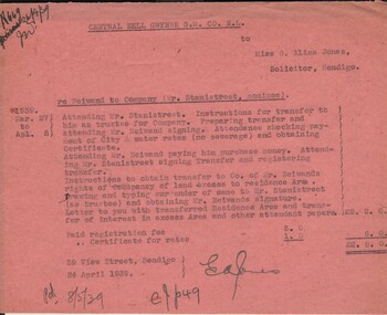
Document - MISS G ALICE JONES COLLECTION: ACCOUNT
Central Nell Gwynne G. M. Co. N. L. to Miss G. Alice Jones. Pink paper dated Mar. 27 to Apl. 5 and 24 April 1939. re Neiwand to Company (Mr. Stanistreet, nominee). Account details costs and work involved in transfer to Co. of Mr. Niewands rights of occupancy of land excess to residence Area and payment to him. Total cost £2.8.0. "R669 26/4/39" written in the top left corner.miss g. alice jones collection - account, central nell gwynne g. m. co n l., mr neiwand, mr stanistreet -
 Bendigo Historical Society Inc.
Document - LANDS OFFICE: CERTIFIED PLAN REGISTER
Document: hard cover journal. Buff cover with embossed edges. Spine has red insert with 'Certified Plan Register' printed in gold. 250 pages, with index in front of register. LH page: number, date of receipt, name, parish, tracing book, plan, decision of Board of land and works, gazette page, name of surveyors, date of survey, sent to, date. RH page: précis of minute. Dated 1878 - 1893, includes areas in central and northern Victoria.plan register, lands office, bendigo, plans, surveyed, victoria, northern victoria -
 Bendigo Historical Society Inc.
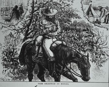
Slide - DIGGERS & MINING. LIFE OF THE SELECTORS, c1876
BHS CollectionDiggers & mining. Life Of The Selectors. Minor carring baby while riding horse, people at table on the left at top rear. Minor boiling the billy, and a small child in the tent at the rear right of picture. Markings; Life Of The Selectors 1860-1890. Set 432 No.2 Free. Selection by Minors - ‘’The Australian Sketcher,' Jan 22, 1876. Caption at bottom of sketch; Free By The Minors. Rear left caption; Before the Land Court. Caption rear right; A residence. Used as a teaching aid.Visual Education Centreeducation, tertiary, goldfields -
 Melbourne Tram Museum
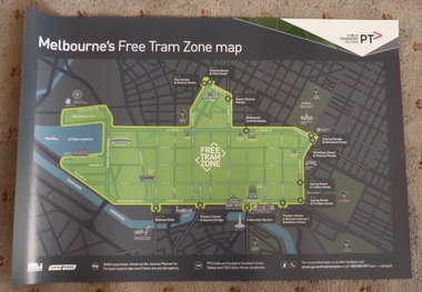
Poster, Public Transport Victoria (PTV), "Melbourne's Free Tram Zone Map", Sep. 2014
Set to two full colour posters printed on a plasticized based sheet, titled ""Melbourne's Free Tram Zone Map". 626.1 - Poster showing the tram lines that the free travel is allowed, locations, land marks, contact numbers and has the PTV logo in the top right hand corner. 626.2 - Poster showing the logo or tram stop id that the free tram zone travel applies to. See Reg Items 1954, and 1956 for associated printed materials and 2790.2 for driver announcements.trams, tramways, yarra trams, ptv, maps, free tram, melbourne -
 Bacchus Marsh & District Historical Society
Map, Bullengarook Parish, County of Bourke
An undated parish plan map for the parish of Bullegarook. This parish area is close to the Bacchus Marsh district and borders some of the areas contained within the former Bacchus Marsh Shire and present day Moorabool Shire.A single page paper map showing the parish plan map for Bullengarook. This parish area contains the locality of Bullengarook and parts of the Wombat State Forest and is close to the town of Gisborne. A cadastral map showing land ownership. The map is not dated but a very similar map held by the State Library of Victoria is estimated to date from about 1927. The map is pasted into a bound volume containing 76 maps or plans in total. High resolution digital image stored on BMDHS computer network. bullengarook parish maps -
 Bendigo Historical Society Inc.
Document - CENTRAL NELL GWYNNE MINE: RESTORATION OF POPPET LEGS
Handwritten paper regarding restoration of poppet legs, request for additional area of land to cover area occupied by engine beds and engine house and painting of the legs with primer. Small piece of paper mentions South Nell Mine commenced operations 7//2/41 and Mine Reports Mr. Jackman from the Mines Dep't has had typed, Carlisle United, Central Nell Gwynne Mine and Fortuna Hustlers. Images 3509.10a,10b,10c,10d,10emine, gold, central nell gwynne mine, central nell gwynne mine, restoration of poppet legs, mr jackman, mines dep't, carlisle united, central nell gwynne mine, fortuna hustlers -
 City of Moorabbin Historical Society (Operating the Box Cottage Museum)
Document - Genealogy Chart Henry Dendy (Photocopy), 19 thC
In 1840 Henry Dendy, a farmer in Surrey, England acquired a "Special Survey" from the Commissioners for Land and Emigration which gave Dendy the right to choose land in Port Phillip for the "bargain basement" price of only £1 per acre for 5120 acres, (an area of 8 square miles). The Special Survey also included the right to "the shipment of a worker for every £20 spent on land, whose free passage was paid by the Crown, equalling a total of 100 workers ". Accordingly Dendy sold his English holdings and paid the required £5120 and arrived in Melbourne in February 1841. However by this time land in the new colony was selling for £5 - £40 per acre. Because Henry Dendy possessed the order from the Colonial Office in London he was able to successfully oppose Super-intendant LaTrobe's attempts to alter the price of the land. Dendy appointed Jonathan Were, (an entrepreneur, who had arrived in 1839), as his Manager and who later became a partner. Together, Dendy and Were decided on an area 5 miles south from Melbourne, bounded by North Road, East Boundary Road, South Road and to the west by Port Phillip Bay. Were and Dendy pitched their tents in the area now known as ' Park St, Brighton' and sank a well near the corner of 'St Andrew's St and Wells St'. By 1845 J.B Were and Company had bought almost half of Dendy's land and Were built himself "Moorabbin House" in Were St Brighton made from stone, quarried from local cliffs. It was still standing in 1924. Legend records Moorabbin is named after the Aboriginal word for ' Mother's Milk ' The soil is very fertile and well supplied with water especially in the area called 'East Brighton' - now known as Bentleigh and East Bentleigh - By 1850 the area had developed with numerous market gardens, dairy farms, fruit gardens and vineyards supplying food for the growing population of Melbourne.In 1840 Henry Dendy, a farmer in Surrey, England acquired a "Special Survey" from the Commissioners for Land and Emigration which gave Dendy the right to choose land in Port Phillip for the price of only £1 per acre for 5120 acres. This land was called Brighton in the Parish of Moorabbin, County of Bourke and emigrants developed the land establishing market gardens , dairy and poultry farms that provided the food for the growing population of Melbourne. A photocopy of the Genealogy Chart of the Dendy Family that Henry Dendy brought with him when he emigrated to Melbourne 1841Genealogy signs and descriptionsdendy henry, dendy's special survey brighton 1841, governor gipps, captain lonsdale, super-intendant latrobe, port phillip, melbourne, new south wales, squatters, emmigrants, county of bourke, parish of moorabbin, early settlers, pioneers, market gardeners, dairy farmers, fruit farms, moorabbin, bentleigh, brighton, cheltenham, were jonathan binn, -
City of Moorabbin Historical Society (Operating the Box Cottage Museum)
Document, Henry Dendy family Shield
In 1840 Henry Dendy, a farmer in Surrey, England acquired a "Special Survey" from the Commissioners for Land and Emigration which gave Dendy the right to choose land in Port Phillip for the "bargain basement" price of only £1 per acre for 5120 acres, (an area of 8 square miles). The Special Survey also included the right to "the shipment of a worker for every £20 spent on land, whose free passage was paid by the Crown, equalling a total of 100 workers ". Accordingly Dendy sold his English holdings and paid the required £5120 and arrived in Melbourne in February 1841. However by this time land in the new colony was selling for £5 - £40 per acre. Because Henry Dendy possessed the order from the Colonial Office in London he was able to successfully oppose Super-intendant LaTrobe's attempts to alter the price of the land. Dendy appointed Jonathan Were, (an entrepreneur, who had arrived in 1839), as his Manager and who later became a partner. Together, Dendy and Were decided on an area 5 miles south from Melbourne, bounded by North Road, East Boundary Road, South Road and to the west by Port Phillip Bay. Were and Dendy pitched their tents in the area now known as ' Park St, Brighton' and sank a well near the corner of 'St Andrew's St and Wells St'. By 1845 J.B Were and Company had bought almost half of Dendy's land and Were built himself "Moorabbin House" in Were St Brighton made from stone, quarried from local cliffs. It was still standing in 1924. Legend records Moorabbin is named after the Aboriginal word for ' Mother's Milk ' The soil is very fertile and well supplied with water especially in the area called 'East Brighton' - now known as Bentleigh and East Bentleigh - By 1850 the area had developed with numerous market gardens, dairy farms, fruit gardens and vineyards supplying food for the growing population of Melbourne. dendy henry, dendy's special survey brighton 1841, governor gipps, captain lonsdale, super-intendant latrobe, port phillip, melbourne, new south wales, squatters, emmigrants, county of bourke, parish of moorabbin, early settlers, pioneers, market gardeners, dairy farmers, fruit farms, moorabbin, bentleigh, brighton, cheltenham, were jonathan binn, -
 City of Moorabbin Historical Society (Operating the Box Cottage Museum)
Document - Pedigree of Henry Dendy, c1840 Original ; Copy 1985
This is a copy of the document brought by Henry Dendy to the Colony in 1841. In 1840 Henry Dendy, a farmer in Surrey, England acquired a "Special Survey" from the Commissioners for Land and Emigration which gave Dendy the right to choose land in Port Phillip for the "bargain basement" price of only £1 per acre for 5120 acres, (an area of 8 square miles). The Special Survey also included the right to "the shipment of a worker for every £20 spent on land, whose free passage was paid by the Crown, equalling a total of 100 workers ". Accordingly Dendy sold his English holdings and paid the required £5120 and arrived in Melbourne in February 1841. However by this time land in the new colony was selling for £5 - £40 per acre. Because Henry Dendy possessed the order from the Colonial Office in London he was able to successfully oppose Super-intendant LaTrobe's attempts to alter the price of the land. Dendy appointed Jonathan Were, (an entrepreneur, who had arrived in 1839), as his Manager and who later became a partner. Together, Dendy and Were decided on an area 5 miles south from Melbourne, bounded by North Road, East Boundary Road, South Road and to the west by Port Phillip Bay. Were and Dendy pitched their tents in the area now known as ' Park St, Brighton' and sank a well near the corner of 'St Andrew's St and Wells St'. By 1845 J.B Were and Company had bought almost half of Dendy's land and Were built himself "Moorabbin House" in Were St Brighton made from stone, quarried from local cliffs. It was still standing in 1924. Legend records Moorabbin is named after the Aboriginal word for ' Mother's Milk ' The soil is very fertile and well supplied with water especially in the area called 'East Brighton' - now known as Bentleigh and East Bentleigh - By 1850 the area had developed with numerous market gardens, dairy farms, fruit gardens and vineyards supplying food for the growing population of Melbourne. A copy of a paper chart of the Pedigree of Henry Dendy in a wooden frame with glassPedigree / of the branch of the family / DENDY moorabbin, brighton, henry dend special survey 1841 y, early settlers, pioneers, market gardeners -
Glen Eira Historical Society
Document - Helenslea, Shelford CEGGS
One page of undated and unattributed handwritten notes regarding the grant of Helenslea land to Sir George Stephen and providing assessment numbers and information on the number of rooms and occupants of Helenslea for the period 1860 to 1889.hood judge, stephen george sir, helenslea, land subdivision, caulfield north, hood crescent -
 Greensborough Historical Society
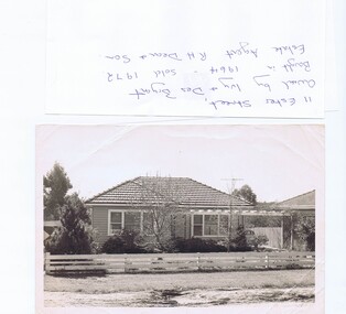
Photograph - Photograph (copy), 11 Ester Street Greensborough, 1972
11 Ester Street Greensborough was owned by Ivy and Des Bryant. Bought in 1964 and sold 1972. Estate agent R.H .Dean and Son. The land has since been subdivided and units built.Copy of black and white photographCaption written on copybryant family, ester street greensborough -
 Greensborough Historical Society
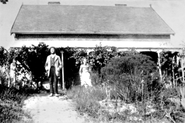
Photograph - Digital image, Charles and Ellen Partington at Willis Vale, 1878c
Photograph of Charles and Ellen (nee Whatmough) Partington at the family home "Willis Vale" on the Plenty River at Greensborough. Charles bought the land from Mr. Edwin Willis Maygar on 30/09/1878.Digital copy of black and white photograph.partington family, charels partington, ellenpartington, ellen whatmough, willis vale -
 Greensborough Historical Society
Folder of documents, Black Family in Greensborough and Watsonia, 1924o
Collection of copies of documents and plans relating to land owned by the Black Family in Greensborough and Watsonia, and its sale by auction and subdivision to form the suburb of Watsonia following the building of Watsonia Railway Station in 1924History of the development of the suburb of WatsoniaLoose-leaf folder, pages in file protectorsblack family, watsonia -
 Eltham District Historical Society Inc
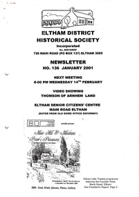
Newsletter, Newsletter, No. 136 January 2001
Contents: • Next meeting, Video: Thomson of Arnham Land • February Meeting • The Eltham Connection (Continued) • Annual General Meeting • 2001 Program • President’s Report • Nillumbik Citizen of the Year • Other News The Shire of Eltham Historical Society was formed in October 1967. The first newsletter of the Society was issued May 1978 and has been published continuously ever since on a bi-monthly basis. With the cessation of the Shire of Eltham in late 1994, the Society's name was revised to Eltham District Historical Society and this name first appeared with issue No. 103, July 1995. The collection of the Society's newsletters provides a valuable resource on the history of the Society's activities, office bearers and committee members, guest speakers and subjects of historical interest pertinent to the former Shire of Eltham and the Eltham District.A4 photocopied newsletter distributed to membersnewsletter, eltham district historical society, shire of eltham historical society -
 Eltham District Historical Society Inc
Photograph, George Coop, Two Harris (Blue) trains at the siding at Hurstbridge Railway Station, 6 December 1980, 1980
View from driver's cabin The Harris trains operated in Melbourne 1956-1988. They were full of asbestos and were taken out of service, wrapped in plastic and buried in land fill near Clayton Digital TIFF file Scan of 35mm Ilford FP4 black and white transparencyhurstbridge railway station, harris (blue) train -
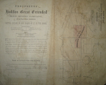 Federation University Historical Collection
Plan and Prospectus, Plan and Prospectus of the Haddon Great Extended Gold Mining Company
The Haddon Great Extended GMC was formed sometime in the 1870s for the purpose of mining 270 acres of land lying to the south-west of the Racecourse Company (who at that stage had a shaft at the depth of 86 feet)A printed piece of paper with a prospectus on the left and a plan on the right. The plan includes a shaded area representing the Haddon Great GMC, and shows neighbouring companies such as Racecourse GMC, Haddon Consols, Reform GMC, Haddon Co, and also shows Russel's Private Propert and Roach's Private Company, and the Trap-Rock Formation.haddon great extended gmc, wc elder, william levey, c thorburn, john langdon, hb forster, national bank of australasia, haddon, racecourse company, h.b. forster, w.c. elder, john langdon, william levey, c. thorburn, john langdon, shares, racecourse goldmining company, reform gold mining company, haddon consols, haddon great extended gold mining company, russell -
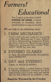 Federation University Historical Collection
Leaflet, School of Mines Ballarat: Offer of Education for Farmers
Pamphlet offering support to "men of the Land" who wish to extend their education. Help offered with mechanics, plumbing, carpentry, blacksmithing and woolclassing, husbandry and pasture improvement. This offer was extended by the Council of The School of Mines.Light fawn paper with dark brown printballarat school of mines, education, mechanics, plumbing, carpentry, blacksmithing, woolclassing, school council