Showing 10391 items
matching plan
-
 Bendigo Historical Society Inc.
Document - Eaglehawk Primary School Architect's Plan for Toilets, March 1980
Architect's plan for the Eaglehawk Primary school Toilets, David M. Breaden - Architects 145 High St Bendigo File 742 Scale 1:100history, national trust bendigo collection, bendigo, eaglehawk primary school, school -
University of Melbourne, Burnley Campus Archives
Document - Student Work, Jamie Sweetman, Assignment 1: Landscape Construction Portfolio, 2017
landscape design, construction, assignment, student work -
Canterbury History Group
Document - Frognall - History, Royal Australian Air Force
Photocopy of a 38 page booklet compiled by Royal Australian Air Force Engineers Cadet Squadron , includes maps, house floor plan, photographs and footnotescanterbury, royal australian air force engineers cadet squadron, hicks> clarence, laycock> burdett, frognall, mont albert road, maps, elgar's special survey -
Canterbury History Group
Ephemera - An Edwardian Classic, 29 Golding Street, Canterbury, 2000
Real Estate Advertisement for auction of 29 Golding Street Canterbury on 11th November 2000. includes coloured photographs of interior and exterior and floor and site planscanterbury, golding street -
Canterbury History Group
Ephemera - 12 Golding Street, Canterbury, 1993
Real Estate Advertisement for the auction of 12 Golding Street on 16th October {1993]. includes a black and white sketch of the front of the house and floor and site plans.canterbury, golding street, sinclair & co -
Canterbury History Group
Ephemera - "Shewalton" beloved family home, c2000
Real estate advertisement for the sale of "Shewalton" 22 Victoria Avenue Canterbury. Includes coloured photographs of the interior and exterior, a sketch of the house, and floor and site plans.canterbury, victoria avenue, shewalton, victorian style, swimming pools, rigby family -
Canterbury History Group
Ephemera - 49 Warburton Road Canterbury, [1990]
Real estate advertisement for the sale by auction of 49 Warburton Road Canterbury on Saturday 20 October [1990]. Includes a sketch of the exterior of the house and a floor plan.canterbury, warburton road, edwardian style -
Canterbury History Group
Ephemera - 24 Wentworth Avenue Canterbury, [2002]
Real estate advertisement for the sale by auction of 24 Wentwaorth Avenue Canterbury on Saturday 23 February [2002]. Includes a sketch of the house and floor and site plans.canterbury, wentworth avenue -
Canterbury History Group
Ephemera - 26 Wentworth Avenue Canterbury, 1991
Real estate advertisement for the sale by auction of 26 Wentworth Avenue Canterbury on Saturday August 3 1991. Includes a sketch of the exterior of the house and a floor plan.canterbury, wentworth avenue, golden mile -
Canterbury History Group
Ephemera - 2a Willow Grove Canterbury, [1997]
Real estate advertisement for the sale by auction of 2a Willow Grove Canterbury on 15 November [1997].ncludes a sketch of the exterior of the building and floor and site plans.canterbury, willow grove -
Canterbury History Group
Ephemera - A stunning Victorian vision, [2002
Real estate advertisement for the sale of 35 Chatham Road Canterbury on 21 December 2002. Includes coloured photographs of the exterior and interior, and a plan of the layout of the house.canterbury, chatham road, victorian style, architectural features -
Canterbury History Group
Ephemera - 14 Compton Street Canterbury, [2001]
Real estate advertisement for the sale by auction of 14 Compton Strreet Canterbury on Saturday 30 June [2001] Includes a sketch of the exterior of the house and a floor plan.canterbury, compton street, edwardian style -
Canterbury History Group
Ephemera - 3 Dryden Sreet Canterbury, [2002]
Real estate advertisement for the sale by auction of 3 Dryden Street Canterbury on 16 March [2002]. Includes a sketch of the exterior of the house Includes a floor plan.canterbury, dryden street, timber houses -
Canterbury History Group
Ephemera - 7 Cross Street, Canterbury, c 2009
Real estate advertisement for the sale of "Rosemont" 7 Cross Street Canterbury on 21 November [2009] Includes several coloured photogarphs and floor and site plans.canterbury, rosemont, cross street, victorian style, stained glass, cast iron work -
Canterbury History Group
Ephemera - 186 Prospect Hill Road Canterbury, 1/12/2002 12:00:00 AM
Real estate advertisement for the auction of 186 Prospect Hill Road Canterbury on 7 December 2002. Includes coloured exterior photographs and floor and site planscanterbury, prospect hill road, swimming pools, tennis courts -
Friends of Ballarat Botanical Gardens History Group
Work on paper - Plans for Fencing the Ballarat Botanical Gardens, 2002, Problems With Vandalism and Theft, March, 2003
Fencing of Ballarat Botanical Gardens, because of problems with vandalism and theft. The reasons for the fencing of the Botanical Gardens are stated along with the aim to have the fencing appropriate to the style of the Gardens.2 pages. p.2 has plans on both sides of the page. Wendouree Parade fencing, p.2 and Proposed Fencing Scheme, p.3.The three pages have the Begonia logo in black and white with Ballarat Botanical Gardens superimposed and by Lake Wendouree below in smaller print.john garner collection, garner, dr, fence, vandalism, ballarat botanical gardens, ballarat, gardens, theft, proposed fencing scheme, wendouree parade fencing, elevation detail, adam parrott, ballarat city council, local law no.6, south gardens boundary, lych gates, elevation detail. -
 Lakes Entrance Regional Historical Society (operating as Lakes Entrance History Centre & Museum)
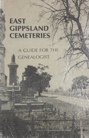
Book, Gibson, Tim, East Gippsland Cemeteries-A Guide for the Genealogist, 1996
A guide to Bairnsdale Cemetery, Victoria, including a plan of the layout, a short history of its development, and genealogical notes of some of the remarkable people buried since commencement.cemeteries, social history, land settlement, memorials -
 Bendigo Military Museum
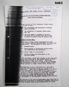
Administrative record - Use of Military maps for water supply planning, 1962
These are typed notes on the use of Military maps for water supply planning. This demonstrates the value of Military Mapping containing accurate relief information that can then be used for water supply planning.5 x A4 pages of typed notes, poorly photocopiedroyal australian survey corps, rasvy, fortuna, army survey regiment, army svy regt, asr, state rivers and water supply commission -
 Ringwood and District Historical Society
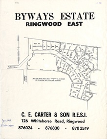
Flyer, Land Sale Brochure, Byways Estate Ringwood East - 1965 Release
Refer also to Reg. No. 5113 for Byways Estate 1967 release, and Reg. No. 5114 for Byways Estate 1970 release.Double-sided real estate notice showing subdivision location with layout of streets and propertiesSubdivision plan includes Alexandra Road, Isabel Avenue, Byways Drive and Buronga Avenue. (Agent) C.E. Carter & Son R.E.S.I. 126 Whitehorse Road, Ringwood (Telephone) 876024, 876830, 8702519. -
 Ringwood and District Historical Society
Newspaper, Scrapbook Clipping, Library Collection, Ringwood, Victoria, `
``Newspaper clipping from The "Post" , 12-7-95 P 5 As part of a new initiative, Maroondah Council has appointed economic manager, Ian Stewart to its new economic development unit. Mr Stewart has a background in law, arts and town planning` -
 Ringwood and District Historical Society
Newspaper, Scrapbook Clipping, Library Collection, Ringwood, Victoria, `
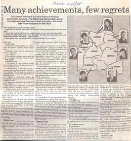
``Newspaper clipping from The "Mail" , 24-3-98 P 8 By Lynne KinseyMany achievements, few regrets. This month marks the first anniversary of the local government elections. The Mail invited Maroondah's seven councillors to have their say on their first year in office and their hopes and plans for the future.` -
Ringwood and District Historical Society
Newspaper, Scrapbook Clipping, Library Collection, Ringwood, Victoria, `
``Newspaper clipping from The "Mail" , 24-3-98 P 8 By Lynne KinseyMany achievements, few regrets. This month marks the first anniversary of the local government elections. The Mail invited Maroondah's seven councillors to have their say on their first year in office and their hopes and plans for the future.` -
Glen Eira Historical Society
Plan - North Road, 631, Ormond
Documents concerning valuations for mortgage on the house at 631 North Road Ormond. Includes letter requesting valuation from Union Trustee Co. of Australia Ltd to W.V. Scott from Mrs. L.E. Leahy’s loan dated 08/11/1955, valuation with detailed description and plan dated 17/11/1955. Also a valuation by W.V. Scott dated 06/03/1961 for Mrs. L.E. Leahy’s mortgage.ormond, north road, brick houses, leahy lucy e., wustemann-howgate a.e., ormond station, hore f.h., union trustee company of australia ltd., australian catholic assurance co., land values -
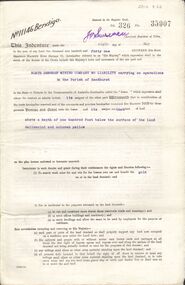 Bendigo Historical Society Inc.
Document - MCCOLL, RANKIN AND STANISTREET COLLECTION: GOLD MINING LEASE NORTH DEBORAH MINING COMPANY, 6th May, 1941
6 page indenture document plus plan, between King George VI and North Deborah Mining company, no liability, Parish of Sandhurst, dated 6th May 1941. Lease number 11146 Bendigo. ' all that piece of land above a depth of one hundred feet below the surface of the land delineated and coloured yellow' Signed by J. Stanistreet, manager. Plan shows excised area in pink. Excised below 100ft shown in yellow ( lease 11146 ) On top of plan ' Mining district of Bendigo, County of Bendigo, Parish of Sandhurst. Area section has been amended to show 1 rood, 14 perches. Leases on plan : No. 9988, 11013, 11062, 11033, 11146, 10753, 11020. Streets: Sullivan Street, Hargreaves Street, Violet Street, Queen Street, King Street. Railway line shown. Scale 8 chains to 1 inch.bendigo, mining, north deborah mining company, north deborah mine, j stanistreet, sullivan heargreaves, queen, king streets. -
Clunes Museum
document
INFORMATION ABOUT A STAMP SHOE FROM A CORNISH STYLE SQUARE-HEAD STAMP BATTERY POSSIBLY USED BY PORT PHILLIP MINE, CLUNES, FROM MATTHEW CHURCHWARD, SENIOR CURATOR, ENGINEERING & TRANSPORT, MUSEUM OF VICTORIA LETTER DATED 15 OCTOBER, 1997. THE GOLDFIELDS AND MINERAL DISTRICTS OF VICTORIA. GOLD ITS OCCURRENCE AND EXTRACTION, PLAN OF GOLD MINING COMPANIESINFORMATION RECEIVED REGARDING THE PORT PHILLIP MINE; Including .1 COPY OF ARTICLE 12TH MAY, 1858 FROM "THE ARGUS." MELBOURNE. .2 LETTER FROM "SCIENCEWORKS" TO MR. ALAN KEEBLE DATED 15/10/1997 (3 Pages) .3 SECTION OF MERCURY, TROUGHS, STAKES & STAMPS (Extract taken from publication, The Gold Fields, Mineral Districts of Victoria, by R. Brough Smyth F.G.S, published by Queensberry Hill Press 1979) .4 GOLD. ITS OCCURRENCE AND EXTRACTION (Extract taken from publication, Gold: Its Occurrence and Extraction by Alfred G. Lock F.R.G.S published by E. & F. N. Spon 16 Charing Cross London 1882) .5 PLAN OF GOLD MINING CO'S. CLUNES (Extract taken from Dicker's Mining Record 26/3/1867, page 173. https://trove.nla.gov.au/work/32734386?q&versionId=39944948) local history, mining, company exploration -
Port Melbourne Historical & Preservation Society
Plan, A J Duncan, Draughtsman, Plans and Sections of Tramsway, May 1891
Plans and typeset descriptions of a proposal to run a cable tram under the Yarra from Williamstown to Melbourne (Falls Bridge) via Port Melbourne. Oriniginally submitted to Victorian Legislative Assembly 1889; this updated 1891 version has 10 pages, and includes an added section to take tramway to Sandridge Road as far as St. Kilda Road. A company has now formed to back the proposal being re-presented to the Legislative Assembly. (Copy of 46.2)Signed by Edward Clark 2-6-1891, with Borough stamp on cover; initialed, ditto, on page 2; signed by A.J. Duncan page 2.transport - tramways, town planning - proposals shelved, williamstown, edward clark, town clerks, mr jennings, austral - anglo tramway and general agency co ltd, a j duncan -
 Kew Historical Society Inc
Photograph - Brick and Stucco Bungalow, J E Barnes, c.1920
The Kew Historical Society's map collection includes a substantial number of real estate subdivision plans, mainly of Kew but also of surrounding suburbs in Melbourne. Most of the subdivision plans date from the 1920s and 1930s when the districts old homes and local farmland were being split up to accommodate residential growth in the postwar period. These early plans were assembled by a local firm, Jas R Mather & McMillan, which had an office in Cotham Road. Many of the plans, and sometimes photos, were annotated by the agents.Subdivision plans are historically important documents used as evidence for the growth of suburbs in Australia. They frequently provide information about when the land was sold as well as evidence relating to surveyors and real estate and financial agents. The numerous subdivision plans in the Kew Historical Society's collection represent working documents, ranging from the initial sketches made in planning a subdivision to printed plans on which auctioneers or agents listed the prices for which individual lots were sold. In a number of cases, the reverse of a subdivision plan in the collection includes a photograph of a house that was also for sale by the agent. These photographs provide significant heritage information relating house design and decoration, fencing and household gardens.The photograph may also be aesthetically significant depending o the importance of the photographic atelier.Real estate photograph for a local agent by the Kew photographer, Josiah Earl Barnes. The photo is of a weatherboard or brick rendered bungalow with a twisted wire fence. Given Barnes' status a a Kew photographer, the house is probably locate din Kew or East Kew. Unfortunately the handwritten information on the mount bordering the photo is damaged and cannot be read. The bungalow has a gabled, tiled roof with terra cotta finials at the front of both gables. The house has a central doorway, framed by a pseudo portico supported by four wooden columns. On each side of the doorway, at the front, there are paired sash windows, which, like the half-timbered gable, are picked out in a darker colour.Handwritten, mostly illegible description by selling agent on mount surround: " .... in Diningroom, Drawing Rooms, ... Photographers details printed on mount: "J. E. Barnes / Photo / Phone 1966 Haw KEW"houses - kew, bungalows - kew, real estate photographs, j.e. barnes -- photographer -
 Kew Historical Society Inc
Photograph - Victorian Double-fronted Brock Villa, Cotham Road, c. 1919
The Kew Historical Society's map collection includes a substantial number of real estate subdivision plans, mainly of Kew but also of surrounding suburbs in Melbourne. Most of the subdivision plans date from the 1920s and 1930s when the districts old homes and local farmland were being split up to accommodate residential growth in the postwar period. These early plans were assembled by a local firm, Jas R Mather & McMillan, which had an office in Cotham Road. Many of the plans, and sometimes photos, were annotated by the agents.Subdivision plans are historically important documents used as evidence for the growth of suburbs in Australia. They frequently provide information about when the land was sold as well as evidence relating to surveyors and real estate and financial agents. The numerous subdivision plans in the Kew Historical Society's collection represent working documents, ranging from the initial sketches made in planning a subdivision to printed plans on which auctioneers or agents listed the prices for which individual lots were sold. In a number of cases, the reverse of a subdivision plan in the collection includes a photograph of a house that was also for sale by the agent. These photographs provide significant heritage information relating house design and decoration, fencing and household gardens.The photograph may also be aesthetically significant depending o the importance of the photographic atelier.Real estate photographs of a classic double-fronted late Victorian brick villa. It central location in Cotham Road, Kew enabled the selling agent to note its proximity to the tram. With seven rooms, all ‘modern conveniences’, and land of 66×167, the house was to be sold for £1100. The villa has a number of interesting features including a pattern within the slate roof as well as the use of polychrome brickwork under the eaves and on the façade. The intricacy of the cast iron lace is emphasised by the line of projecting wooden blocks above it. The picket gate is painted a different colour to the pickets of the fence. The house has a name (illegible) that is attached to the inset cast iron lace of the central projecting gable in the veranda. Stamped on mount: "Kew. Central. Close tram. / Comfortable Brick Villa. / Containing 7 rooms / Modern conveniences: / Land 66 x 167. Sold 1100 pounds:"houses - kew, victorian villas, real estate photographs, cotham road - kew -
Glen Eira Historical Society
Plan - Pritchard Steam Power Company
This file contains one item: 1/A draft of a plan for a museum exhibit from the Spirit of Enquiry Workbook, by Denis Shephard, and dated 07/08/2007, pertaining to alternative energy research within the suburbs of Melbourne between 1950 and 1980. Much of the content is irrelevant to Glen Eira. However; one of the two principle subjects of the exhibit, discussed between pages 20 and 28, is the work of Ted Pritchard, who was based out of Caulfield. Ted and his father, Arnold Pritchard, aspired to reinvent the steam engine for use within the contemporary era. To that end, they fitted a Chevrolet pickup truck with one of their prototypes – with the result being one of the main items constituting the exhibit. Ted’s interest in steam power had been spurred by a working tabletop model of a steam engine that Arnold built for him – which constitutes another of the exhibit’s items. Also included is a brief history of the development of Caulfield. The plan is embellished with numerous images, with relevant ones including maps of Caulfield and black-and-white photographs of the Pritchards’ truck, model and workshop.engines, engineering, engineers, inventions, inventors, steam engines, steam power vehicles, pritchard ted, pritchard arnold, pritchard steam power company, caulfield, shephard denis, pritchard mrs., trucks, pritchard edward, holland grove, balaclava road, workshops, grants, pritchard automotive steam designs, caulfield racecourse, caulfield technical school, caulfield trades school, caulfield technical college, chisholm institute, camden town, southdown knitting company, home street, fl hutchison, fowler street, vale knitting mills, nepean road, winterfold spinning mills, acme knitting mills, glen eira road, mj ryan knitwear, leather industry, lane joseph, hotham street, casey william, glen huntly road, pickering william, paris leather manufactory, woorayl street, tv tatchell, premier wire works, webb street, chesterfield ha, manufacturing industry, victory milk plant, bl coram & sons -
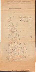 Bendigo Historical Society Inc.
Document - MCCOLL, RANKIN AND STANISTREET COLLECTION: PLAN OF AREA LEASE 10425, 10733 AND 10734, 1934
Plan of area applied for on lease No 10425, 10733 and 10734. Applied for by Mr. R.A. Rankin. Plan shows Marong Road, state school site ; leases held by H.E. Kronk, Francis Gramann; T. Wearne; C.E. Foggitt; A. Pitcher, Crown land and Aur. licences also marked. Lease numbers marked on plan. Map signed on bottom by Garnet G. Birch on 26.11.1934. On top Rh side in black pen " applications for the Minister of Mines Authority under section 5 (1) of the Mines Act 1928 to enter upon and occupy for mining purposes such portion of allotments lodged on 19/2/35'gold, mining, lease, mining, leases, kronk, garnet g. birch