Showing 10536 items
matching lander
-
 Kew Historical Society Inc
Photograph - Flooding of the Yarra River in North Kew, 1934
North Kew, now divided between Kew and Kew East, bordered the Yarra River. As such, it was a region subject to flooding in the Yarra Valley. Development beyond this point (ie Kellett Grove) was limited by the City of Kew's planning regulations. Prior to urban development, the area since European settlement and the first land sales in the district in the 1840s, had been used for dairy farming. Small sepia snapshot of floodwaters taken from near Kellett Grove, in what was then known as North Kew. The point of view is from a backyard looking towards Fairfield. In the foreground ar two men in a rowboat.Verso: OUR BACKYARD / Stamped 3 163yarra river -- north kew, floods -- yarra valley, floods -- north kew, floods -- 1934, natural disasters -- kew -
 Kew Historical Society Inc
Photograph - Flooding of the Yarra River in North Kew, 1934
North Kew, now divided between Kew and Kew East, bordered the Yarra River. As such, it was a region subject to flooding in the Yarra Valley. Development beyond this point (ie Kellett Grove) was limited by the City of Kew's planning regulations. Prior to urban development, the area since European settlement and the first land sales in the district in the 1840s, had been used for dairy farming. Small sepia snapshot of floodwaters taken from near Willsmere Road, in what was then known as North Kew. The point of view is looking towards Fairfield. In the foreground are two figures viewing a group in a rowboat in the middle of the flooded river. Semi-submerged street lighting indicates that entire streets had been. overwhelmed by the flood waters. Verso: WILLSMERE ROAD NORTH KEW / Stamped 3 163yarra river -- north kew, floods -- yarra valley, floods -- north kew, floods -- 1934, natural disasters -- kew, willsmere road -
 Kew Historical Society Inc
Photograph - Flooding of the Yarra River in North Kew, 1934
North Kew, now divided between Kew and Kew East, bordered the Yarra River. As such, it was a region subject to flooding in the Yarra Valley. Development beyond this point (ie Kellett Grove) was limited by the City of Kew's planning regulations. Prior to urban development, the area since European settlement and the first land sales in the district in the 1840s, had been used for dairy farming. Small sepia snapshot of floodwaters in North Kew. The point of view is of two houses belonging to local families that were surrounded by floodwater. Verso: HYATTS HOUSE / WILLSMERE ROAD / Stamped 3 163yarra river -- north kew, floods -- yarra valley, floods -- north kew, floods -- 1934, natural disasters -- kew, willsmere road -
 Kew Historical Society Inc
Photograph - Flooding of the Yarra River in North Kew, 1934
North Kew, now divided between Kew and Kew East, bordered the Yarra River. As such, it was a region subject to flooding in the Yarra Valley. Development beyond this point (ie Kellett Grove) was limited by the City of Kew's planning regulations. Prior to urban development, the area since European settlement and the first land sales in the district in the 1840s, had been used for dairy farming. Small sepia snapshot of floodwaters in North Kew, from the rear of 8 Kellett Grove. Verso: OUR BACKYARD / Stamped 52yarra river -- north kew, floods -- yarra valley, floods -- north kew, floods -- 1934, natural disasters -- kew, willsmere road -
 Kew Historical Society Inc
Photograph - Grandfather and granddaughter in the yard of 8 Kellett Grove, Kew, 1934
North Kew, now divided between Kew and Kew East, bordered the Yarra River. As such, it was a region subject to flooding in the Yarra Valley. Development beyond this point (ie Kellett Grove) was limited by the City of Kew's planning regulations. Prior to urban development, the area since European settlement and the first land sales in the district in the 1840s, had been used for dairy farming. Vivid photograph contrasting domestic life and relationships with natural disasters such as the flood of 1934.Small sepia snapshot of a grandfather and granddaughter sitting in the backyard of 8 Kellett Grove, North Kew, with the floodwaters stretching behind them.Verso: GRANDDAD AND I IN BACKYARDyarra river -- north kew, floods -- yarra valley, floods -- north kew, floods -- 1934, natural disasters -- kew, willsmere road -
 Kew Historical Society Inc
Photograph - Submerged houses in River Avenue, North Kew, 1934
North Kew, now divided between Kew and Kew East, bordered the Yarra River. As such, it was a region subject to flooding in the Yarra Valley. Development beyond this point (ie Kellett Grove) was limited by the City of Kew's planning regulations. Prior to urban development, the area since European settlement and the first land sales in the district in the 1840s, had been used for dairy farming. Vivid photograph contrasting domestic life and relationships with natural disasters such as the flood of 1934.Small sepia snapshot of two submerged houses belonging to local families in River Avenue, North Kew, during the 1934 floods. The view is presumably from near Kellett Grove looking north towards Fairfield.Verso: COES & HYATTS ROOF / RIVER AVENUE / Stamped: 6414yarra river -- north kew, floods -- yarra valley, floods -- north kew, floods -- 1934, natural disasters -- kew -
 Kew Historical Society Inc
Photograph - Flooding of the Yarra River in North Kew, 1934
North Kew, now divided between Kew and Kew East, bordered the Yarra River. As such, it was a region subject to flooding in the Yarra Valley. Development beyond this point (ie Kellett Grove) was limited by the City of Kew's planning regulations. Prior to urban development, the area since European settlement and the first land sales in the district in the 1840s, had been used for dairy farming. Vivid photograph contrasting domestic life and relationships with natural disasters such as the flood of 1934.Small sepia snapshot of the donors grandfather rescuing the family dog's kennel from rising floodwaters at the rear of 8 Kellett Grove, North Kew, .Verso: DAD SECURING NIPPY'S DOG KENNEL / Stamped 6414yarra river -- north kew, floods -- yarra valley, floods -- north kew, floods -- 1934, natural disasters -- kew -
 Kew Historical Society Inc
Photograph - Flooding of the Yarra River in North Kew, 1934
North Kew, now divided between Kew and Kew East, bordered the Yarra River. As such, it was a region subject to flooding in the Yarra Valley. Development beyond this point (ie Kellett Grove) was limited by the City of Kew's planning regulations. Prior to urban development, the area since European settlement and the first land sales in the district in the 1840s, had been used for dairy farming. .Small sepia snapshot of a local family's house in what was then River Avenue, North Kew being surrounded by floodwaters.Verso: THE SIDE OF RYANSyarra river -- north kew, floods -- yarra valley, floods -- north kew, floods -- 1934, natural disasters -- kew -
 Kew Historical Society Inc
Photograph - Flooding of the Yarra River in North Kew, 1934
North Kew, now divided between Kew and Kew East, bordered the Yarra River. As such, it was a region subject to flooding in the Yarra Valley. Development beyond this point (ie Kellett Grove) was limited by the City of Kew's planning regulations. Prior to urban development, the area since European settlement and the first land sales in the district in the 1840s, had been used for dairy farming. .Small sepia snapshot of what was then River Avenue, North Kew submerged by floodwaters.The photo was taken in the vicinity of 8 Kellett Grove, North Kew. Verso: TAKEN FROM OUR STREET JUST SEE A BIT OF RYAN'S FENCE / 1934yarra river -- north kew, floods -- yarra valley, floods -- north kew, floods -- 1934, natural disasters -- kew -
 Kew Historical Society Inc
Photograph - Flooding of the Yarra River in North Kew, 1934
North Kew, now divided between Kew and Kew East, bordered the Yarra River. As such, it was a region subject to flooding in the Yarra Valley. Development beyond this point (ie Kellett Grove) was limited by the City of Kew's planning regulations. Prior to urban development, the area since European settlement and the first land sales in the district in the 1840s, had been used for dairy farming. .Small sepia snapshot of the devastation caused by the 1934 flood.The photo was taken in the vicinity of Kellett Grove, North Kew and includes the roof of Chipperfield's Boathouse as well as other local houses.Verso: THIS IS CHIPPERFIELD'S BOAT SHEDS & COES & WILLIAMS TAKEN FROM OUR STREET / 1934yarra river -- north kew, floods -- yarra valley, floods -- north kew, floods -- 1934, natural disasters -- kew, chipperfields boathouse -
 Kew Historical Society Inc
Photograph - Kew Junction, Herald & Weekly Times, 1962
This is an aerial oblique image looking north. It shows Kew Junction before construction of VicRoads (Country Roads Board), Murphy's (Leo's) supermarket, and office towers. It also shows a building on the land now known as the Raoul Wallenberg Reserve, the Kew Municipal Offices in Walpole Street, and St Paul's School for the Blind in Fernhurst Grove, and Kew Bowling Club in Wellington Street.An aerial photograph of Kew Junction, showing the intersection of High Street South, Studley Park Road, Princess Street, High Street and Denmark Street. A number of buildings, now demolished can be identified in the photo, including Jellis’ Bakeries on the corner of Princess Street and Studley Park Road." Annotation on reverse: "Kew Historical Society from Mr L. H. Chinner".kew junction, aerial photograph (kew), oblique aerial, st paul's school for the blind, kew municipal offices, high street kew, studley park road, kew war memorial, kew post office, kew police station, kew court house, high street south, kew, wellington street kew, denmark street kew -
 Surrey Hills Historical Society Collection
Planning report, City of Boroondara, City of Boroondara planning report re 171 Union Road, Surrey Hills, 19/07/2004
171 Union Road was part of the Thomas Zeplin estate. It originally had a Victorian house on it built by the Zeplin family. This was leased by Dr Percy Liddle and then Dr James Landells Blakie. Dr Blakie purchased land diagonally opposite at 174 Union Road and had a purpose-built home / surgery constructed. Later the site was occupied by COR then a BP petrol station.A detailed proposal regarding the redevelopment of the petrol station site on the corner of Union Road and Montrose Street, Surrey Hills into a 2 storey office and shop building with basement parking and access from Montrose Street. It includes attachments showing plans, elevations and details regarding objectors. The application was granted subject to additional conditions being met. union road, redevelopment, shops, town planning -
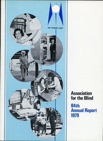 Vision Australia
Administrative record - Text, 84th Annual report 1979 Association for the Blind of Victoria, 1979
Articles in annual report include: the opening of the new Craft, Recreation and Activities Centre at Mirridong and Kelaston Community Day Hospital, 60 bed nursing home at Mt Eliza almost nearing completion, waiting for approval for 30 bed nursing ward at Shepparton, block of land secured at Warragul for future day centre, loss of Stan Middleton and retirement of Alex Cook.1 printed volume with illustrationsannual reports, association for the blind -
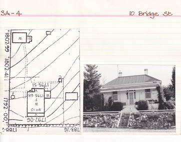 The Beechworth Burke Museum Research Collection
Card (Series) - Index Card, George Tibbits, 10 Bridge Street, Beechworth, 1976
George Tibbits, University of Melbourne. Faculty of Architecture, Building and Town & Regional PlanningIndex system that support the research for Beechworth : historical reconstruction / [by] George Tibbits ... [et al]Arranged by street names of BeechworthEach index card includes: street name and number of property, image of property, allotment and section number, property owners and dates of ownership, description of the property according to rate records, property floor plan with dimensions.beechworth, george tibbitsbeechworth, george tibbits -
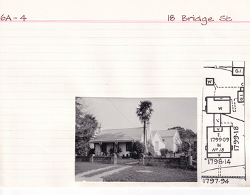 The Beechworth Burke Museum Research Collection
Card (Series) - Index Card, George Tibbits, 18 Bridge Street, Beechworth, 1976
George Tibbits, University of Melbourne. Faculty of Architecture, Building and Town & Regional PlanningIndex system that support the research for Beechworth : historical reconstruction / [by] George Tibbits ... [et al]Arranged by street names of BeechworthEach index card includes: street name and number of property, image of property, allotment and section number, property owners and dates of ownership, description of the property according to rate records, property floor plan with dimensions.beechworth, george tibbitsbeechworth, george tibbits -
 Bendigo Historical Society Inc.
Photograph - T C WATTS & SON COLLECTION: MARKS STREET, BENDIGO, 1929
Andrew Balsillie (30/8/1874-28/7/1949. For 50 years he was associated with the Bendigo Mutual Permenant Land and Building Society and was its secretary from 1916 to 1945. He was the son of Andrew and Maria (nee Laing), who operated Edinburgh House selling ladies and gentlemen's clothing. Andrew Jnr. married Helen (Nellie) Calder in 1903.Black and white photographs (2) mounted on rectangular brown board. House, stained weatherboard board to sill height, rough cast above, bow lead- light window on right, leadlight windows on left, louvred vents to both front gables, tiled roof, roughcast verandah surround and pillars, 3 steps to veranda level, one chimney visible, small white veranda lamp, woven wire fence. Gate wooden gateway with lintel. On back of photo 18a: 'Sold Balsillie £875 sewered, or £825 plus sewerage. Stamp with T.C. Watts & Son, 253 Mitchell St., Bendigo., 12 April, 1929' On back of 18b. A. Balsillie, Marks St., £950 (crossed out ) £875, sewered or £825 plus sewerage.' May 1929.Frank A. Jeffree Bendigobuilding, residential, t.c. watts and son, balsillie, marks street bendigo -
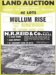 Ringwood and District Historical Society
Flyer, Land Auction Advertisement, Mullum Rise, Ringwood - 1970
Double sided leaflet with aerial view of part of Ringwood showing subdivision site, terms of sale, layout of streets and allotments, and summary of local features and services.Land auction, Saturday, 10th October (1970). 45 home sites. Subdivision includes Mullum Mullum Road, Hugh Street, Rollington Drive, Cassandra Court, and Jeffrey Drive. Surveyors - R.G. Lee Pty. Ltd., 6 Davis Street, Richmond. Agents - N.R. Reid & Co., 173 Coleman Parade, Glen Waverley, (Telephone) 560 0355 A.H. 560 0361 and Safeway Centre, Boronia Road, Boronia, (Telephone) 762 1022 A.G. 795 2887, also at East Malvern and Mount Waverley. -
 Ringwood and District Historical Society
Photograph, Maroondah Highway West, Ringwood- c1920. Original Ringwood Market, Cnr. Maroondah Highway and Ringwood Street
Black and white photograph of wooden building. (2 copies)Typed under one copy: "Original Ringwood market and saleyards at corner of Maroondah Hwy and Ringwood St.. Charter St is beyond saleyards on right. SEC office now occupies site of buildings seen. c1920" Typed under second copy: "Original Ringwood market cnr Maroondah Highway and Ringwood St. opposite present clock tower site. 1920. Now SEC office. Sign on building reads- "Ringwood Market. D.G. McClelland & Co.. Stock Station Land Estate Agents. Alex McClelland, Auctioneer. -
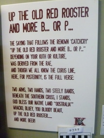 National Vietnam Veterans Museum (NVVM)
Poster - Poster, Information Board, Up the Old Red Rooster
White plastic rectangle with an Australian Limmerick. Print is maroon. 9 RAR symbol in roman numerals on bottom right.Up the old red rooster and more B....or P.... The saying that follows the renown "Catchcry" "Up the odl red rooster and more B... or P... Depending on your kuth or kulture, was derived from the rae, and though we know the corus line, here, for posternity, is full verse: Two arms, two hands, two steely bands, beneath the Southern Ceoss, I stands, God bless, our native land "Oostralia", whacked,bluey, you bloody beaut, up the old red rooster.....and beer9 rar, document -
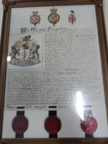 National Wool Museum
The Australian Estates Company Ltd. Coat of Arm Certificate
May have been given to The Australian Estates Company in the 1970's when sold to CSR or Elders.Bronze framed certificate coat of arms with smaller frame below explaining coat of arms.The shield shows the Southern Cross (being the Arms of Victoria) but on a white background to indicate wool and to avoid being identical with the Victoria Arms (which have a blue background). The inner shield shows the conventional way of indicating estates with green and gold squares. The sword is the sword of St Paul, indicating the London activities of the company. The Shorthorn Bull and Merino Ram explain themselves, as does the sugar cane. The helmet and decoration above are conventional, green and gold being chosen to indicate land and the wealth derived therefrom. -
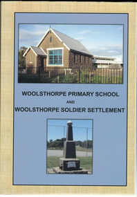 Warrnambool and District Historical Society Inc.
Book, Woolsthorpe Primary School and Woolsthorpe Soldier Settlement
History of the Woolsthorpe Primary School and Woolsthorpe Soldier SettlementThis is a soft-cover book with a blue and buff- coloured front cover featuring photographs of the Woolsthorpe Primary School and the Woolsthorpe War Memorial. The back cover has photographs of the R.S.L. Badge and the Woolsthorpe Primary School. It has 160 pages. non-fictionHistory of the Woolsthorpe Primary School and Woolsthorpe Soldier Settlementwarrnambool, woolsthorpe, soldier settlement -
 Warrnambool and District Historical Society Inc.
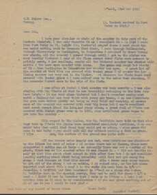
Document, copy, Typed Augustus Bostock to G B Palmer
Augustus Bostock was the 9th child of Robert & Rachael Bostock of Vaucluse Epping Forest, Van Diemen’s Land. He was only 4 years old when his mother died. He was inspired by his father to seek his fortune in the Western District of Victoria. He arrived around 1850. He married Margaret Aitkin in July 1865. Augustus owned several properties in the district and leased others. He sat on the court of Warrnambool, Mortlake or Hexham as required. He resided at Marramook in Hawkesdale and later moved to Vaucluse in Hopetoun Road Warrnambool, where he died in 1920 at the age of 87. He was involved in many aspects of life in the Western District, racing, cricket, and social activities to name a few. This letter relates to the earliest recollections of Augustus Bostock and relate to land of the Western district from Camperdown, Darlington, through to Grasmere, Rosebrook and Yambuk. He writes about the terrain, vegetation and stock. This is one of a number of documents which relate to the Bostock family who were one of the most important pioneering families of the Western District. They owned and leased various properties around Warrnambool and were involved in many aspects of social and business life. As Augustus Bostock arrived in the district in 1845, this is one of the earliest accounts of the district.Cream sheet newsprint quality, typed in dark blue.Dated 23rd Oct 1912, Augustus Bostock to G B Palmer of Terang.augustus bostock, warrnambool, vaucluse -
 Kiewa Valley Historical Society
Folder - Kiewa Methodist Church, 1917 to 1962
The copy of a letter written by Harry H. Simmonds of Huon notes that "the church existed in 1905. It was built by Hill and McCormack with timber donated by Mr Ned Dunstan on ground donated by Mr James Thomas probably in the late 1800s. It was possibly called a Methodist Church because the donor of the land was a Methodist. It was used by the three Protestant Groups and maintenance was paid for by an annual area collection.The house on the west side was a Presbyterian Manse for many years and the block of ground on the north side was known as the Manse paddock in which the minister grazed his cow and horse." In 1936 there was a fence between the Kiewa Methodist Church was the Presbyterian Church in Kiewa. Its Certificate of Title is Volume 5134 Folio 1026783 (Sept. 1942.) In 1952, the church was made of wood with an iron roof. In 1954. Request to Yackandandah Shire re a fence from Kiewa Consolidated School entrance to the unused hedge adjacent to the Church. In 1958 there was correspondence re 'the strip of land on each side of the Church.' Churches were an important part of life during the late 19th century and early to mid 20th century and were built in the centre of town as was this one. These papers give an understanding of the work involved in maintaining a church. The letters and 'book' give a lot of names of local families involved with the Methodist Church at Kiewa. Yellow plastic spiral folder with 18 pages enclosed in clear plastic sleeves.Papers enclosed include accounts, payments, tenders and other correspondence relating to the Methodist Church at Kiewa dating from 1932 to 1962. Of particular interest is a black cardboard cover book dated 1917 re collection of donations from listed people. The latest date in the book is 1942.Enclosed in first plastic sleeve is a letter from the donor, Kathie Vines dated 15th July 2013methodist church; kiewa; harry h. simmonds; yackandandah council; -
 Eltham District Historical Society Inc
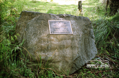
Photograph, In memory of David Christmas
The David Christmas memorial is situated on the south side of One Tree Hill Road, at Watsons Creek. As a young man, Welshman David Christmas had been transported to Van Dienman's Land for a relatively minor offence. In 1836, having received a pardon, he came to Port Phillip, where, in 1842, he was hired as a shepherd by district pioneer, Joseph Stevenson. In 1992, a roadside plaque commemorating the shepherd who gave his name to the district was set in place over his presumed bush gravesite. The plaque was unveiled by two of Stevenson's grandsons, Bruce and Don Ness. FROM: Christmas Hills Past and Present, Yarra Glen & District Historical Society, 2004. 1842-1992 In memory of David Christmas born Cardiganshire 1797 Transported to Van Dieman's Land for the term of his natural life 1822 Granted a free pardon 1826 "From this humble shepherd these hills have gained their name" Roll of 35mm colour negative film, 1 strip (2 frames)Fuji 200david christmas, christmas hills, memorials, watsons creek, plaque -
 Warrnambool and District Historical Society Inc.
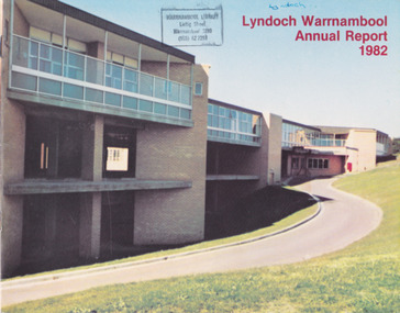
Document - Lyndoch Warrnambool 1982 Annual Report
This is the 1982 Annual Report for Lyndoch Home and Hospital for the Aged, Warrnambool. It contains lists of Board Members, a President’s Report, Lyndoch’s Aims, financial reports, photographs and a list of Life Governors. Lyndoch Home for the Aged was established in 1952 and has developed with a wide range of facilities for the aged since that date. The original Lyndoch property near the mouth of the Hopkins River was owned by a Melbourne tea merchant, George Rolfe, who bought the land when there were on the site only a couple of cottages and a larger building which had been a school, Warrnambool Grammar, run by Henry Kemmis. Rolfe acquired the land in the 1870s and named the property Lyndoch after the town in the Barossa Valley where he had lived. He owned Lyndoch for 44 years and it was his stepdaughter, Florence Lake who built in the 1920s the bungalow known as Lyndoch which forms the original building of the Lyndoch Home for the Aged, Today the facility is called Lyndoch Living. This 1982 report is kept for the benefit of researchers wanting details of the history of Lyndoch over the past 30 or 40 years. This is a booklet with a plasticized cover with a white back and a multi-coloured front cover. The front cover has a photograph of a Lyndoch building. There are six double-sided pages with printed material and photographs on white paper and a yellow and orange strip across the top of the pages. The pages are stapled.On front cover: Lyndoch Warrnambool Annual Report 1982 Stamp of Warrnambool Library On back cover: A red circle with the words ‘Lyndoch, Comfort and Security for Aged Folk’ lyndoch aged care facility, warrnambool, lyndoch warrnambool -
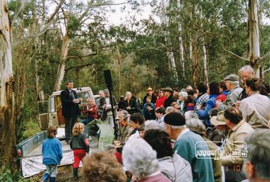 Eltham District Historical Society Inc
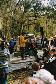
Photograph, Unveiling ceremony of a plaque in memory of David Christmas, 11 October 1992, 11/10/1992
The David Christmas memorial is situated on the south side of One Tree Hill Road, at Watsons Creek. As a young man, Welshman David Christmas had been transported to Van Dienman's Land for a relatively minor offence. In 1836, having received a pardon, he came to Port Phillip, where, in 1842, he was hired as a shepherd by district pioneer, Joseph Stevenson. In 1992, a roadside plaque commemorating the shepherd who gave his name to the district was set in place over his presumed bush gravesite. The plaque was unveiled by two of Stevenson's grandsons, Bruce and Don Ness. FROM: Christmas Hills Past and Present, Yarra Glen & District Historical Society, 2004. The plaque reads: 1842-1992 In memory of David Christmas born Cardiganshire 1797 Transported to Van Dieman's Land for the term of his natural life 1822 Granted a free pardon 1826 "From this humble shepherd these hills have gained their name"Colour photographactivities, ceremonies, david christmas, memorials, unveiling ceremony, christmas hills, watsons creek -
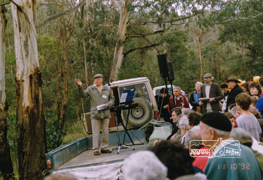 Eltham District Historical Society Inc
Photograph, Unveiling ceremony of a plaque in memory of David Christmas, 11 October 1992, 11/10/1992
The David Christmas memorial is situated on the south side of One Tree Hill Road, at Watsons Creek. As a young man, Welshman David Christmas had been transported to Van Dienman's Land for a relatively minor offence. In 1836, having received a pardon, he came to Port Phillip, where, in 1842, he was hired as a shepherd by district pioneer, Joseph Stevenson. In 1992, a roadside plaque commemorating the shepherd who gave his name to the district was set in place over his presumed bush gravesite. The plaque was unveiled by two of Stevenson's grandsons, Bruce and Don Ness. FROM: Christmas Hills Past and Present, Yarra Glen & District Historical Society, 2004. The plaque reads: 1842-1992 In memory of David Christmas born Cardiganshire 1797 Transported to Van Dieman's Land for the term of his natural life 1822 Granted a free pardon 1826 "From this humble shepherd these hills have gained their name"Colour photographactivities, ceremonies, david christmas, memorials, unveiling ceremony, ness family, watsons creek, christmas hills -
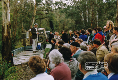 Eltham District Historical Society Inc
Photograph, Unveiling ceremony of a plaque in memory of David Christmas, 11 October 1992, 11/10/1992
The David Christmas memorial is situated on the south side of One Tree Hill Road, at Watsons Creek. As a young man, Welshman David Christmas had been transported to Van Dienman's Land for a relatively minor offence. In 1836, having received a pardon, he came to Port Phillip, where, in 1842, he was hired as a shepherd by district pioneer, Joseph Stevenson. In 1992, a roadside plaque commemorating the shepherd who gave his name to the district was set in place over his presumed bush gravesite. The plaque was unveiled by two of Stevenson's grandsons, Bruce and Don Ness. FROM: Christmas Hills Past and Present, Yarra Glen & District Historical Society, 2004. The plaque reads: 1842-1992 In memory of David Christmas born Cardiganshire 1797 Transported to Van Dieman's Land for the term of his natural life 1822 Granted a free pardon 1826 "From this humble shepherd these hills have gained their name"Colour photographactivities, ceremonies, david christmas, memorials, unveiling ceremony, christmas hills, watsons creek -
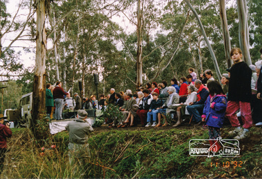 Eltham District Historical Society Inc
Photograph, Unveiling ceremony of a plaque in memory of David Christmas, 11 October 1992, 11/10/1992
The David Christmas memorial is situated on the south side of One Tree Hill Road, at Watsons Creek. As a young man, Welshman David Christmas had been transported to Van Dienman's Land for a relatively minor offence. In 1836, having received a pardon, he came to Port Phillip, where, in 1842, he was hired as a shepherd by district pioneer, Joseph Stevenson. In 1992, a roadside plaque commemorating the shepherd who gave his name to the district was set in place over his presumed bush gravesite. The plaque was unveiled by two of Stevenson's grandsons, Bruce and Don Ness. FROM: Christmas Hills Past and Present, Yarra Glen & District Historical Society, 2004. The plaque reads: 1842-1992 In memory of David Christmas born Cardiganshire 1797 Transported to Van Dieman's Land for the term of his natural life 1822 Granted a free pardon 1826 "From this humble shepherd these hills have gained their name"Colour photographactivities, ceremonies, david christmas, memorials, unveiling ceremony, christmas hills, watsons creek