Showing 24370 items
matching matthew-creek
-
 Bendigo Historical Society Inc.
Document - CONNELLY, TATCHELL, DUNLOP COLLECTION: LETTERS RE JOHN LYNCH
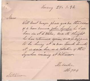
Documents (2) pinned together Messages dated .28.3.1892, 1.4.1892 and 31.3.1892 Memo to Const. Meager seeking information re John Lynch, late of Terrick Terrick, said to be a relative of the Lyhnches residing at Mitiamo. On rear of memo ' John Lynch brother to Matthew and Patt Lynch has notyet returned to this colony. He is supposed to be living in the dist of Dubbo N.S.W., signed C.F. Major, Const. 2908, Kerang' Connelly, Tatchell & Dunlop response attached re information enclosed above.business, legal, connelly, tatchell & dunlop, connelly, tatchell & dunlop, john lynch, terrick terrick, mitiamo -
 Bendigo Historical Society Inc.
Newspaper - JENNY FOLEY COLLECTION: FAMINE RELIEF
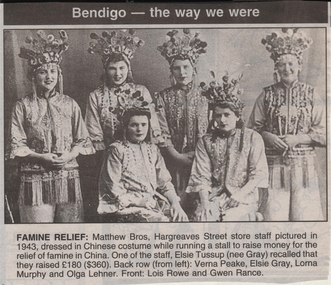
Bendigo Advertiser ''The way we were'' from 1999. Famine relief: Matthew Bros, Hargreaves Street store staff pictured in 1943, dressed in Chinese costume while running a stall to raise money for the relief of famine in China. One of the staff, Elsie Tussup (nee Gray) recalled that they raised 180 pounds ($360). Back row from left: Verna Peake, Elsie Gray, Lorna Murphy and Olga Lehner. Front: Lois Rowe and Gwen Rance.newspaper, bendigo advertiser, the way we were -
 NMIT (Northern Melbourne Institute of TAFE)
Photograph: CTS 1958 School Council with Minister for Education
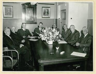
Black and white photograph inside a photo manila folder taken by Allan Studios. On reverse side of photo there are names in position of sitters. From left to right they are: C.P. Jordan - Headmaster, Cr. Spencer-Harper - President Technical Schools Service, Hon. J.S.Bloomfield - Minister of Education, Mr. F.J.Rojo - President, [Blank], Kevin Tatchell - Principal, R. Provan - Past President, J.C.Glare - Vice-President. Portrait of Matthew Richmond, first principal of CTS is hanging on the wall behind.collingwood technical school, school council, nmit -
 Mt Dandenong & District Historical Society Inc.
Photograph, St Matthew's Church Girls Friendly Society, late 1920s
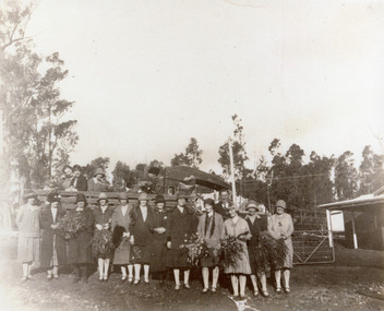
St Matthew's Church Girls Friendly Society Outing with transport provided by Wally Breen's truck. Scene shows group of girls in front of truck, some holding large bunches of flowers. circa late 1920s. From back L - R Vi Hardon, Edna Eakin, Florrie James, ?, ?, Mrs Eakin, Sheila Shellow, Mrs Hamilton, Iris Dorey, ?, Mrs Wally Breen, Nora McLarty, Mavis Giddens, Wally Breen, Rita Shaw, Jessie Lyle.st matthew's church, girls friendly society, olinda, vi hardon, edna eakin, florrie james, iris dorey, sheila shellow, wally breen, nora mclarty, mavis giddens, rita shaw, jessie lyle -
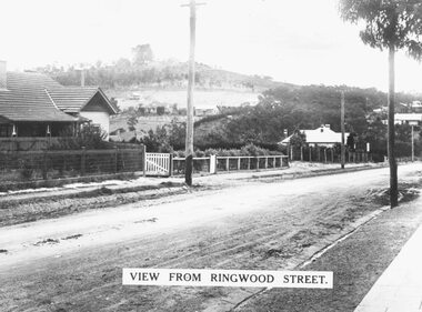 Ringwood and District Historical Society
Photograph, Looking north along Ringwood Street from corner of Bond Street, Taken mid 1930s
Typed below photograph, "Looking north along Ringwood Street from corner of Bond Street. Mullum Creek is in dip. Note how bare Loughnan hill was. Taken mid 1930s". -
 Bacchus Marsh & District Historical Society
Map, Lerderderg Park Lands sale plan. 1911
This plan was for the sale of parcels of land from the Lerderderg Park Estate property in 1911. Advertising for the sale appeared in the Bacchus Marsh Express newspaper through July of 1911. The property was situated only a few kilometers from the township of Bacchus Marsh. The agents for the sale were L. A. Fairbairn & Co.Lerderderg Park Estate was a significant and early colonial property in the Bacchus Marsh area. This plan provides details about the first time the property was subdivided for sale. It is therefore documents an important moment in the history of this property and the broader trend of the subdivision of older and larger properties in the district.A single page paper plan showing allotments of land for sale from the Lerderderg Park property owned by John Wills. The parcels of land for sale are coloured in red.The Lerderderg River and Pyke's Creek Irigation Channel shown on the plan are in blue ink. The rest of the plan is a dark cream or beige colur with the text in black ink. The plan has been extensively annotated with hand-written notes indicating the names of people who purchased the various parcels of lands and the prices paid for those lands. Part of the top of the plan containing some text appears to be missing. The plan is pasted into a bound volume containing 76 maps or plans in total. Top: Have received instructions to Sell, account Mr John Wills, his renowned LERDERDERG PARK LANDS, so well and favourably known throughout the Commonwealth. In areas from 3 acres to 1276 acres. Every lot is either rich lucerne land (or portion now under lucerne) with some higher land adjoining Railway Station, and 2 Milk factories within 2 miles, absolutely the finest land in Victoria. Bottom: THIS IS THE FIRST SUBDIVISIONAL SALE of Rich Flats in Bacchus Marsh since the Pyke's Creek Scheme, and every lot is commanded by it. Only 32 miles from Melbourne.bacchus marsh victoria maps, land sales, lerderderg park estate, land subdivision -
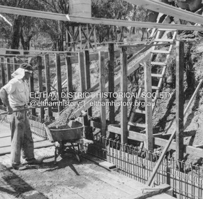 Eltham District Historical Society Inc
Album - Photograph, J.A. McDonald, Eltham-Yarra Glen Road, 26 Jan. 1956
Watsons Creek Floor pour 27th January, 1956Record of various Shire of Eltham infrastructure works undertaken during the period of 1952-1962 involving bridge and road reconstruction projects, sometimes with Eltham Shire Council Project Reference numbers quoted. It was during this period that a number of significant improvements were made to roads and new bridges constructed within the shire that remain in place as of present day (2022). In many situations, the photos provide a tangible visible record of infrastructure that existed throughout the early days of the Shire. The album was put together by or under the direction of the Shire Engineer, J.A. McDonald.infrastructure, road construction, shire of eltham, bridge construction, eltham-yarra glen road, w.e. wolf, watsons creek, 1956-01-27 -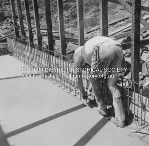
 Eltham District Historical Society Inc
Album - Photograph, J.A. McDonald, Old Healesville Road, Sep. 1958
Paul Creek Road September 1958 Looking eastRecord of various Shire of Eltham infrastructure works undertaken during the period of 1952-1962 involving bridge and road reconstruction projects, sometimes with Eltham Shire Council Project Reference numbers quoted. It was during this period that a number of significant improvements were made to roads and new bridges constructed within the shire that remain in place as of present day (2022). In many situations, the photos provide a tangible visible record of infrastructure that existed throughout the early days of the Shire. The album was put together by or under the direction of the Shire Engineer, J.A. McDonald.infrastructure, shire of eltham, bridge construction, road construction, old healesville road, paul creek road, 1958-09 -
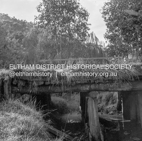 Eltham District Historical Society Inc
Negative - Photograph, J.A. McDonald, Heidelberg-Kinglake Road, 11 May 1961
Yow Yow Creek bridge 11 May 1961Record of various Shire of Eltham infrastructure works undertaken during the period of 1952-1962 involving bridge and road reconstruction projects, sometimes with Eltham Shire Council Project Reference numbers quoted. It was during this period that a number of significant improvements were made to roads and new bridges constructed within the shire that remain in place as of present day (2022). In many situations, the photos provide a tangible visible record of infrastructure that existed throughout the early days of the Shire. The album was put together by or under the direction of the Shire Engineer, J.A. McDonald.1961-05-11, heidelberg-kinglake road, infrastructure, bridge construction, shire of eltham, yow yow creek -
 Eltham District Historical Society Inc
Photograph, Looking west along Bridge Street, from Main Road, Eltham, February 1968, Feb 1968
Shows the Diamond Creek bridge and part of Susan Street In February 1968 an unknown person took a series of photos from the Eltham Hotel at Pitt Street heading north along Main Road through the shopping centre to just north of Elsa Court covering the length of the section of Main Road which was duplicated shortly thereafter. Shows the condition and environment of the streesscape of Main Road, Eltham immediately prior to the duplication between Pitt Street and Elsa Court through the shopping centre. Also shows a number of shops and businesses that operated at that time.Black and white photographduplication, eltham, main road, bridge street, susan street -
 Ballarat Heritage Services
Souvenir - Postcard Booklet Image, The Blowhole, Hepburn, Victoria, c1945
The Blowhole was blasted by Chinese miners to divert Sailor's CreekA black and white photographic image of the Blowhole at Hepburn.blowhole, hepburn, sailors creek -
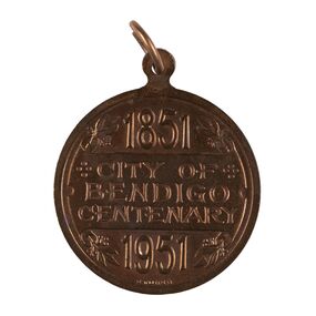 City of Greater Bendigo - Civic Collection
Medal - City of Bendigo Centenary Medal, Stokes and Son
Medal commemorating the centenary of the establishment of a settlement on Bendigo Creek. Stokes & Sonsobverse; 1851 / City of Bendigo Centenary / 1951. Reverse: In centre: Coat of arms (Bendigo), Below Progresscity of greater bendigo medals -
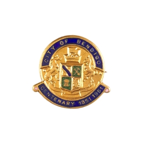 City of Greater Bendigo - Civic Collection
Decorative object - City of Bendigo Centenary decorative pin, Stokes and Son, 1951
Medal commemorating the centenary of the establishment of a settlement on Bendigo Creek. (.1) Small, circular, gold pin with blue and green enamel. below. (.2) Seventeen numbered paper envelopes containing single pin.Face of pin has the City of Bendigo Coat of Arms in relief with 'City of Bendigo' above and 'Centenary 1851 - 1961' city of greater bendigo medals -
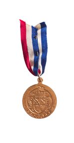 City of Greater Bendigo - Civic Collection
Medal - City of Bendigo Centenary Medal with ribbon, Stokes and Son
Medal commemorating the centenary of the establishment of a settlement on Bendigo Creek. Stokes & Sons pressed medal with gold finish to commemorate the 100th anniversary of the establishment of Bendigo. obverse; 1851 / City of Bendigo Centenary / 1951. Reverse: In centre: Coat of arms (Bendigo), Below Progresscity of greater bendigo medals -
 Falls Creek Historical Society
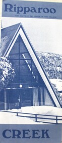
Booklet - Ripparoo Lodge, 1973
Ripparoo Lodge was one of the earliest Lodges established in the Falls Creek Village. In the 1960s, Bob and Noelene Lee moved to Falls Creek to run Ripparoo Lodge. They later built Attunga Ski Lodge. Both of these lodges still operate successfully in the 2020s.This brochure is significant because it represents one of the early lodges at Falls Creek. A fold out brochure printed in blue and white, it include some images and cartoons of people enjoying hospitality at Ripparoo. Information on tariffs and services is included.Title - Ripparoo The happiest ski lodge in the village.falls creek accommodation, ripparoo, falls creek lodges -
 Falls Creek Historical Society
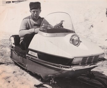
Photograph - Julian Newton Brown on Yamaha SL 351
Julian Newton-Brown arrived at Falls Creek in 1957. He had studied Pharmacy at Melbourne University. After developing a love for the mountains, Julian moved to Mt. Beauty and then Falls Creek. He worked for the SEC in the test laboratory at Rocky Valley reading weather instruments. By working several jobs, Julian was able to build a small lodge of 10 beds named “Arundel”, located at 18 Slalom Street, Falls Creek. The lodge is now the “Elk at Falls”. Arundel prospered and Julian extended it to include 32 beds and changed its name to "Julian’s” in 1961. When alcohol restrictions were eased in Falls Creek, Julian built a night club which he called “Big Julian’s” and later “THE MAN”. When Julian and his wife Beth retired and left Falls Creek, their son took over running the lodge. An active community man, Julian was a member of the Falls Creek Chamber of Commerce, a member of the SES, a stakeholder in Falls Creek, an author and a documentary maker. Julian Newton-Brown died in May 2020. In 2003 when this flyer was published operation of Julian's Lodge transferred from Julian and his wife Beth to their son Charlie Brown, a former Australian Champion and World Cup skier and his wife, Bena.This item is significant because it gives details of an important lodge at Falls Creek, Victoria.A black and white image of Julian Newton Brown testing a Yamaha SL 351 in 1968.julian's lodge, julian newton brown, falls creek ski lodges, accommodation falls creek, charlie brown -
 Kiewa Valley Historical Society
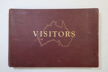
Visitors Book - Nissen Paradise, Welcome to our Nissen Paradise - Ski Nissen School - 1953 to 1960
Nissen Lodge was built by 1953 at Falls Creek. The first lodge at Falls Creek was built in 1947 by SECV staff members. By the 1954 Ski Season, Falls Creek Alpine Village had 10 club lodges, plus a ski tow house and a commercial lodge that both provided skier accommodation. Several other club lodges were under construction. The Nissen Alpine Club operated a rope tow with a 240m rise in altitude..Ski lessons were also available. Re: Tony and Skippy St Elmo Beveridge See KVHS 1113 By 1953, the SECV was issuing entry permits for private cars used by skiers with bookings in a Falls Creek lodge.The Nissen Ski Lodge was one of the early ski lodges at Falls Creek. Toni St Elmo Beveridge was involved in the early development of skiing at Falls Creek including assisting with the building of the early lodges, and establishing the Nissen Ski School. See KVHS 1113. The book was later used for visiors to the KVHS museum located in the old Tawonga South School.Deep red, bound, thick cardboard book with gold outline of Australia and 'Visitors" on the centre front. Many pages each with a column for Date, Name in Full and Address in Full. Written in ink and pencil both sides of each page with the first date being 14 - 6 - 1953 to 17th September 1960. Entries follow from 1985 to 1994 when the closure of the display at the old South Tawonga Primary School is noted by the KVHS Secretary. The book also has 'Tony & Skippy St Elmo Beveridge' on its cover page. nissen ski lodge, visitors book falls creek, nissen school -
 Orbost & District Historical Society
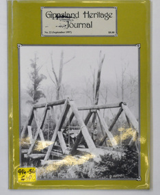
journal, Gippsland Heritage Journal, September 1997
This issue was edited by Meredith Fletcher.This item is a useful reference on the history of Gippsland.A 64 pp magazine, titled Gippsland Heritage Journal. The cover is olive green with a b/w photograph of the Snowy Creek bridge at Mitta Mitta in 1914. The magazine is dated September 1997 and is covered in plastic. It contains photographs and articles on the history of Gippsland.On the outside back cover is a library barcode. On the front is a call no. 994.56 GIPgippsland-heritage-journal history-gippsland -
 Ringwood and District Historical Society
Book, Murray Houghton, Prosit Carl! - A Tribute to Carl (a.k.a. Charles) Walter, 2007
A centenary tribute to Carl (a.k.a. Charles) Walter, (1831-1907), an itinerant potographer and botanist who in his maturer years made Anderson's Creek his home. Includes photographs attributed to Walter, and anecdotes and recollections of author Murray Houghton's ancestors."... By raising his stein in appreciation, the author herein toasts Carl Walter in the accostomed traditional method of 1850s German beer drinkers with a hearty 'Prosit!', i.e., a most warm, enthusiastic and respectful greeting, roughly equivalent to our contemporary custom of saluting a treasured friend with a rousing 'cheers!' or 'good health!'." -
 Halls Gap & Grampians Historical Society
Photograph - Coloured, C 1980s
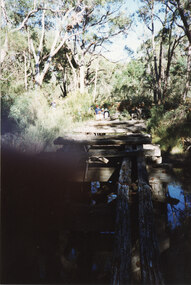
This is a photo of one of the trestle bridges on the Heatherlie Quarry train line. The bridge is located near the current location of "The Pines" campground.The photo is a "front on" of a derelict trestle bridge crossing a shallow creek; many sleepers are missing and thick bush and trees surround the bridge. There are four adults at the end of the bridge, one standing and three seatede. The bottom left hand side of the photo is blurredstructures, bridges, quarrying, heatherlie -
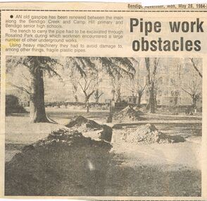 Bendigo Historical Society Inc.
Newspaper - CASTLEMAINE GAS COMPANY COLLECTION: BENDIGO ADVERTISER, 28/05/1984
Cut out from the Bendigo Advertiser of Monday May 28, 1984. ''Pipe work obstacles'' An old gas pipe has been renewed between the main along the Bendigo creek and Camp Hill primary and Bendigo senior high schools.newspaper, bendigo advertiser, gas related item -
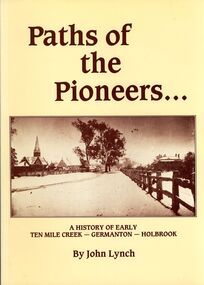 Bendigo Historical Society Inc.
Book - STRAUCH COLLECTION: PATHS OF THE PIONEERS
Soft covered book Paths of the Pioneers, A history of early Ten Mile Creek - Germanton - Holbrook , compiled from the files of the newspapers which have served Germanton, Holbrook, Albury and Wagga Wagga, 104 pages with a map and black & white photographs.John Lynchhistory, australian, new south wales, history-nsw-holbrook-germanton-ten mile creek -
 Bendigo Historical Society Inc.
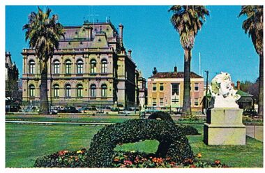
Postcard - LAW COURTS, BENDIGO
Postcard: image shows Law Courts, Bendigo. Former Police Station on RH side of Law Courts, beside Police Station is a Victorian house, bordering the Bendigo Creek and entry into Rosalind Park. In foreground, ivy basket, statue in Conservatory Gardens.Plastichromebendigo, buildings, law courts, bendigo, law courts, police station -
 Bendigo Historical Society Inc.
Document - LETTER: DALEY FAMIILY (EMU CREEK, BENDIGO), 13th February, 1975
Letter re Daley family (Emu creek, Bendigo) 13/2/1975 from E Murray to BHS. Supplied details of family post 1853 - details of number of children and names etc. Request for further information - no substantial answer to request..person, individual, daley family -
 Bendigo Historical Society Inc.
Map - SALISBURY : COUNTY OF BENDIGO, 1965
Map. Salisbury, County of Bendigo, Pompapiel, Yallook, Yarraberb, Yarrayne, Bullock Creek. Drawn and reproduced at the Department of Lands and Survey, Melbourne. Price $1.00. 1965. By authority A.C. Brooks, Government Printer, Melbourne. (number 28 in map cupboard 1)A.C. Brooks,Government Printer, Melbourne.map, bendigo, salisbury -
Bendigo Historical Society Inc.
Map - WARRAGAMBA : COUNTY OF BENDIGO, 29-4-30
Map. Warragamba, County of Bendigo, Pannoomilloo, Kamarooka, Minto, Diggorra. By authority H.J. Green, Government Printer. Piccaninny Creek. Drawn and reproduced at the Deparment of Lands and Survey, Melbourne. 29-3-30. Price2/-. (number 10 in map cupboard 1)H.J. Green, Government Printermap, bendigo, warragamba -
Bendigo Historical Society Inc.
Map - SALISBURY : COUNTY OF BENDIGO, 1965
Map. Salisbury, County of Bendigo, Pompapiel, Yarrayne, Yarraberb, Yallook, Bullock Creek. By Authority: A.C. Brooks, Government Printer, Melbourne. Drawn and reproduced at the Department of Lands and Survey, Melbourne.1965. Price $1.00. (number 6 in map cupboard 1)A.C. Brooks, Government Printermap, bendigo, salisbury -
 Stratford and District Historical Society
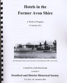
Book, Barraclough, Linda, Hotels in the former Avon Shire: A Work in Progress, 2011
Published book (processed, comb bound) "Hotels in the former Avon Shire: A Work in Progress". 47 pages, illus., A4, Edition May 2012. Includes hotels at Stratford, Nuntin, Delvine, Munro, Stockdale, Cobbanah, Dargo, Grant, Iguana Creek. -
 Tatura Irrigation & Wartime Camps Museum
Photograph - Photograph of Painting, Self Portrait George Rosenkranz, 1945
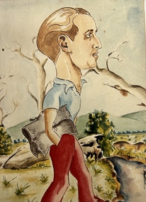
Colour photograph of a self portrait of George Rosenkranz, Graytown camp 1945. Brown hair, blue shirt, red trousers, hand in pocket. Holding a grey satchel bag. Rolling hills in background. Trees, plants and creek right hand bottom.internees, george rosenkranz, graytown victoria