Showing 18004 items
matching heritage
-
 Eltham District Historical Society Inc
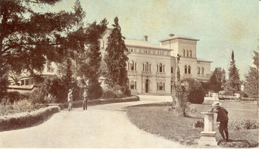
Photograph - Digital Photograph, Marguerite Marshall, Wingrove Cottage, Main Road, Eltham, 8 June 2006
Wingrove Cottage built 1858-1859 of hand made bricks is historically significant for its long association with Charles Wingrove, a prominent figure in Victorian local government, as secretary to the Eltham District Road Board and Shire Council from 1858 to 1904, and Shire Engineer and Secretary to the Heidelberg Road Board. The cottage was used as the office of the Eltham District Road Board and Council for many years It is one of the Shire's oldest dwellings, and one of the few surviving 19th century buildings associated with early Eltham and located in the original Eltham Village Reserve. The symmetrical planting of a pair of Pencil Pines (not visible in photo) is also historically and aesthetically significant as characteristic of the early period of planting in the district and because they are a distinctive landscape feature. In October 2002 new owners demolished the outbuildings attached to the rear of the cottage. Community protest at the demolition resulted in Council issuing a Stop Work order. The owner was issued with a court order in September 2003 to develop a conservation management plan and restore the heritage listed property. The owner sold the property in 2005 to Cameron Construction in 2005 who undertook the restoration work. In 2007 a planning application to build two offices and seven dwellings at the rear of the property was ultimately rejected. The cottage is now the main office for Cameron Construction. Covered under Heritage Overlay, Nillumbik Planning Scheme. Published: Nillumbik Now and Then / Marguerite Marshall 2008; photographs Alan King with Marguerite Marshall.; p57 Wingrove Cottage on Main Road beside Eltham Primary School, is one of the Shire’s most important historical buildings and was central to local government for almost 50 years. The cottage was built in stages from 1858 to 1888 for Charles Symons Wingrove JP. He was the Eltham District Road Board’s first paid secretary and later the Shire Secretary when the board became the Eltham Shire Council. Wingrove held those positions, and that of engineer for a time, for 46 years. He was also one of the main figures in the Municipal Association of Victoria. As Eltham’s first paid municipal officer, Wingrove used one room in his 11 – (originally two) roomed home, as the office for the board then the council. Meetings were held there from the late 1850s (as well as at more central locations) until Wingrove’s retirement in 1904. The cottage is a rare example of a local government office occupying a Road Board /Shire Secretary’s purpose-designed house. The cottage is also significant because it is the oldest largely intact building from the original Eltham township reserve (south of Dalton Street).1 The township had its origins in the 1848 Nillumbik Parish Plan and was one of the state’s earliest township reserves. The rectangular house of handmade bricks, roofed with grey slate tiles and with a veranda encompassing three sides, is reminiscent of those in the central goldfields including Castlemaine. Its overhanging eaves and gables were unlike houses in Melbourne at the time. Wingrove, who was born in 1827, had been a gold digger and a road surveyor. Impossible to imagine in today’s world, Wingrove was also the Shire of Heidelberg’s secretary and engineer for part of the time that he was secretary in Eltham. Living next door to the primary school was a mixed blessing. Wingrove and his wife Katherine, who had ten children, sent their eight surviving children to the school. But they had occasional disputes with the school authorities when their cattle wandered into the schoolyard. Eltham showed Charles Wingrove its appreciation of his services by giving him two illuminated addresses, one after ten years and the other at retirement. Wingrove died in 1905 aged 76 and was buried in the St Katherine’s Church of England cemetery in St Helena. His grave is surrounded by those of family members including his wife, Katherine and two babies, Henry, 12 months and Isobella, 15 months, who died in the mid-1860s. Cottage ownership passed to his wife, then to daughter Caroline and then to daughter Bessie, a Melbourne University graduate and artist. During the Great Depression their brother Walter was the ratepayer. At one stage the Wingrove property extended to Metery Road and included a small creek. The family ran a small dairy and orchard, with associated farm buildings, which were later removed. In 1949 part of the property was compulsorily acquired by the Eltham Primary School, which infuriated owner Bessie Wingrove. She protested in a letter about this ‘monstrous act of unmitigated tyranny’.2 She was the last Wingrove to occupy the cottage and died in 1955. Wingrove descendants sold the house in 1974 and the property was subdivided. In the 1960s the Eltham Shire named the park opposite the cottage in Wingrove’s honour. The cottage has since had several owners including psychiatrist Dr Daniel Kahans, who practised there. In October 2002 late rear additions which had been substantially altered were demolished contrary to council planning controls. This caused a community outcry and resulted in legal proceedings against the owner. Fortunately the historical significance of the demolished section was not as great as the older front part of the building, which has been retained and was later restored.This collection of almost 130 photos about places and people within the Shire of Nillumbik, an urban and rural municipality in Melbourne's north, contributes to an understanding of the history of the Shire. Published in 2008 immediately prior to the Black Saturday bushfires of February 7, 2009, it documents sites that were impacted, and in some cases destroyed by the fires. It includes photographs taken especially for the publication, creating a unique time capsule representing the Shire in the early 21st century. It remains the most recent comprehenesive publication devoted to the Shire's history connecting local residents to the past. nillumbik now and then (marshall-king) collection, cameron construction, charles symons wingrove, eltham, eltham road district board, eltham shire council, main road, wingrove cottage -
 Eltham District Historical Society Inc
Photograph - Digital Photograph, Alan King, Kangaroo Ground General Store, Eltham-Yarra Glen Road, 28 December 2007
The present store was built circa 1900 to replace another which had been destroyed by fire in 1898, which had replaced a predecessor on the opposite side of the road in 1865. The store was also used as a post office until early 2000s. The general store is historically significant because it has a long association with Kangaroo Ground and has been an important centre of community life for more than 120 years - Council meetings used to be conducted in the front room of the store at a time when Kangaroo Ground rivalled Eltham as the major centre of the Shire. The general store is historically and aesthetically significant as one of a group of three well preserved public buildings in the Kangaroo Ground hamlet and as a major heritage component of Kangaroo Ground which was one of the earliest settled areas of the Shire and which has the character of an English village rather than an Australian settlement. Covered under Heritage Overlay, Nillumbik Planning Scheme. Published: Nillumbik Now and Then / Marguerite Marshall 2008; photographs Alan King with Marguerite Marshall.; p77 Today the general store is an uncommon form of trade but the one at Kangaroo Ground continues a long tradition of friendliness and service. For more than 100 years it has been a centre of community life. In the settlement’s early days a previous general store, on the same site, was the meeting place for the Eltham District Road Board, precursor to the Eltham Shire Council. For years Kangaroo Ground rivalled Eltham as the shire’s major centre. It developed very differently from the rest of the shire as its rich soil attracted prosperous Presbyterian Scots who had large agricultural properties.1 The present store was built to replace another one, which had burnt down in 1898, after replacing a predecessor on the other side of the road in 1865. The store retains its outward character and its cellar, although inside it has changed considerably. It now includes a café and offers local produce, milk bar products, grocery items, gas and other fuel. Until early this century the store was also used as a post office. Kangaroo Ground’s first postmaster was Andrew Ross, who first operated from the school opposite, then from his hotel next to the present tennis court site. The first postmaster at this store was Edward Weller, followed in 1868 by James Anderson. At that time a mail coach ran three times a week between Eltham and Woods Point through Kangaroo Ground, Yarra Flats, Healesville, Fernshaw, Marysville and Matlock. Some early postmasters were Rodger, McLaughlin, Greenway and Burns.2 Burns was the only postmaster operating from the store. The others operated from Andrew Ross’s hotel. The mail service improved in 1892 when coaches ran from Melbourne to Queenstown (now known as St Andrews) and changed horses at Kangaroo Ground twice daily. The only telegraph office in the district at that time was at the Kangaroo Ground Post Office. Telegrams to outlying areas such as Queenstown and Kinglake had to be sent by hand. A local resident in the early 1900s often rode his pony to deliver telegrams and was paid one shilling a mile porterage. The store has also contributed to the lighter side of Kangaroo Ground life. During the years that Con Wraight owned the store, between 1906 and 1946, a new piano was needed for the Kangaroo Ground Hall, so monthly dances were held to raise money. When the piano was bought, a grand ball was held in the Kangaroo Ground Hall to celebrate the occasion and supper followed at Mr Wraight’s barn, cleaned especially for the occasion. Every New Year’s Eve, a Scottish piper would set off from between the store and the schoolhouse, playing his pipes, and march to Cameron’s Pigeon Bank homestead on the Kangaroo Ground-Warrandyte Road. Between 1914 and 1922, the store was a station for the Kangaroo Ground Bush Fire Brigade’s tanker. It consisted of a wooden barrel on a cart, fitted with a hand-pump, and stood on the side of the road outside the store. Joy Ness, who belonged to an early Kangaroo Ground family, moved here in 1940 and recalled her impressions of the store at that time: ‘It was a very dark shop stained in a dark colour and on the walls just below the ceiling hung hurricane lamps, ropes, kitchen utensils and other goods for sale. ‘Goods were weighed on a brass scale with weights, on which mothers also weighed their babies, because the nearest Infant Welfare Centre was at Greensborough. The bacon was cut with a hand slicer and later a pot-bellied stove warmed the store. Farmers and other locals used to gossip around it as they collected their daily mail. In those days the butter and cheese were kept in the cellar as no ice was delivered for cooling.’This collection of almost 130 photos about places and people within the Shire of Nillumbik, an urban and rural municipality in Melbourne's north, contributes to an understanding of the history of the Shire. Published in 2008 immediately prior to the Black Saturday bushfires of February 7, 2009, it documents sites that were impacted, and in some cases destroyed by the fires. It includes photographs taken especially for the publication, creating a unique time capsule representing the Shire in the early 21st century. It remains the most recent comprehenesive publication devoted to the Shire's history connecting local residents to the past. nillumbik now and then (marshall-king) collection, eltham-yarra glen road, kangaroo ground general store -
 Eltham District Historical Society Inc
Photograph - Digital Photograph, Alan King, St Andrews Anglican Church, St Andrews, 30 January 2008
Built c.1868, St Andrew’s Anglican Church is Nillumbik Shire’s oldest timber church and is historically, socially, and spiritually significant to the Shire of Nillumbik. The church is historically significant because it may have given its name 'St Andrews' to the town (another suggestion is that the name came from the local hotel), it is also historically significant as one of only four buildings that remain from the Caledonian goldfields era of Queenstown (now St Andrews) and one of only a handful of buildings that survived the 1960s bushfires. The church is historically, socially, and spiritually significant because it has played an important part in community life for more than 150 years; a proposal to move the church in 1984 met with strenuous opposition. Much of the fires on Black Saturday 2009 were the north of the town. The town itself remained intact - as did this heritage building. Covered under Heritage Overlay, Nillumbik Planning Scheme. National Trust of Australia (Victoria) Local significance Published: Nillumbik Now and Then / Marguerite Marshall 2008; photographs Alan King with Marguerite Marshall.; p69 The St Andrews Anglican Church and former St Andrews Primary School, are two reminders of the district’s early days, when it was founded on gold. St Andrews, then called Queenstown, was the earliest goldfield in the Caledonia Diggings.1 It was the Upper Diamond Gold Mining and Administrative Centre, with 3000 miners. Queenstown was also the seat of the Court of Petty Sessions. The church and school then stood close to European and Chinese stores, three hotels, a brewery and a quartz mill.2 In 1861, Queenstown was officially proclaimed a township. From 1865, the name Queenstown was interchangeable with St Andrews, until 1952, when the town was officially named St Andrews. As gold declined from the early 1880s, Queenstown changed dramatically into a settlement of small farms. St Andrew’s Anglican Church, built in 1868, is the Shire’s oldest timber church and possibly gave its name to the township.3 The small timber church was opened on November 1, 1869, by the Dean of Melbourne. Anniversary tea meetings helped raise funds, and in 1889, a three-bedroom parsonage was built alongside. In 1910, the vicar, the Rev Selwyn Chase (and friend of the Scouting Movement’s founder, Baden Powell), established the 1st Queenstown Scout Troop, only two years after Scouting began in Australia. The church was important to the lives of many local residents who were baptised, married and had funeral services there. But by the 1950s the population had decreased and so did the weekly attendances. Around the mid-1960s the church closed, then fell into disrepair. So in the mid 1980s it was sold to the Education Department and was under threat of relocation or demolition. However this caused such opposition from locals,4 that instead, the Anglican church leased it as part of the Panton Hill parish5 and it was reconsecrated in 1987. Queenstown’s first school was held in a tent after transferring from Andersons Creek, Warrandyte.6 From 1858 a church school, Caledonia Diggings, stood west of the main road, a quarter of a mile (0.4km) before Buttermans Track. In 1882 the school was moved from a leased building, owned by headmaster Robert Harris, into a larger building on the corner of the School and the Heidelberg-Kinglake Roads. It had been moved from Smiths Gully and included a teacher’s three-roomed residence.7 In 1887 the school was replaced by the Queenstown State School No 128, although it was also called Caledonia Diggings until 1891. In 1956 it was renamed St Andrews. Still standing, this building is now used as the St Andrews Community Centre and the residence is leased for private use. The original timber-lined room remains alongside the extensions, and is distinctive with its high ceiling and tall small-paned windows. In 1984 a new school was built 500 metres west of the old school. Many residents have contributed much to St Andrews but one family that has done so for several generations is the Harris family. Robert Harris was an active member of the St Andrew’s Anglican Church, and worked hard at improving the town’s amenities until his death in 1887. He was a signatory to the successful 1863 petition to the Chief Commissioner of Police, against the proposed removal of the Court of Petty Sessions and police station at the Caledonia Diggings. The police station stayed in the town until 1917. Harris was Head Teacher of Queenstown State School from 1864 to 1874, then of the Smiths Gully school until it closed in 1882, and he continued teaching at Panton Hill until his death. His son, Robert Charles Harris, was editor and printer of the local newspaper, The Evelyn Observer, from 1873 until 1915. Robert’s son, William Shelley Harris, served in the Boer War and in World War One. In 1928 he became Kinglake National Park’s first park ranger. Robert’s daughter Elizabeth, taught needlework at Queenstown State School, and later ran the post office in Kinglake.This collection of almost 130 photos about places and people within the Shire of Nillumbik, an urban and rural municipality in Melbourne's north, contributes to an understanding of the history of the Shire. Published in 2008 immediately prior to the Black Saturday bushfires of February 7, 2009, it documents sites that were impacted, and in some cases destroyed by the fires. It includes photographs taken especially for the publication, creating a unique time capsule representing the Shire in the early 21st century. It remains the most recent comprehenesive publication devoted to the Shire's history connecting local residents to the past. nillumbik now and then (marshall-king) collection, st andrews, st andrews anglican church -
 Eltham District Historical Society Inc
Photograph - Digital Photograph, Alan King, Rob Roy Hill Climb, 24 November 2007
The Rob Roy Hill Climb originated in 1935 on the property of former Heidelberg Mayor, William Clinton, where he reared the Rob Roy breed of miniature ponies. He established Pleasure Grounds on part of the property attracting groups of Sunday visitors from Melbourne's inner suburbs. Visitors enjoyed a picnic area, pony rides, a dance hall and a tap room. Young men would ride their BSA or Harley Davidson motorcycles to the property which led to regular club-organised hillclimb meetings between 1930 and 1936. In 1935 Clinton offered the use of his property to the Light Car Club of Australia for their hillclimbs. The track was sealed that same year and the hillclimb at Clintons Road was one of only three specially designed bitumen surface hillclimbs in the world, the others being Shelsey Walsh and Prescott Hillclimbs in the UK. The first Light Car Club of Australia hillclimb was held at Rob Roy in February 1937. Covered under Heritage Overlay, Nillumbik Planning Scheme. Published: Nillumbik Now and Then / Marguerite Marshall 2008; photographs Alan King with Marguerite Marshall.; p133 About six times a year the unlikely sound of car engines emerges from deep in the heart of Christmas Hills.* Usually a quiet retreat, the Hills are home to one of the world’s oldest purpose-built motor sport venues - the Rob Roy Hillclimb. When sealed in 1939, the hillclimb at Clintons Road was one of only three specially designed bitumen surface hillclimbs in the world, the others being Shelsley Walsh and Prescott Hillclimbs in the UK.1 The Rob Roy Hillclimb originated in 1935 on the property of former Heidelberg mayor, William Clinton, where he reared the Rob Roy breed of miniature ponies. Rob Roy was the Scottish folk hero and outlaw. On part of his property Clinton established Pleasure Grounds, attracting Sunday parties from Melbourne’s inner suburbs. Visitors enjoyed a picnic area, pony rides, a dance hall and a tap room.2 Young men riding on their BSA or Harley Davidson bikes led to club-organised regular hillclimb meetings, between 1930 and 1936. In 1935 Clinton offered his property to the Light Car Club of Australia for their hillclimbs. In February 1937, the first Light Car Club of Australia hillclimb meeting was held at Rob Roy. Jack Day achieved the fastest time that day for the 760 yard (695m) track at 36 seconds in a Ford V8 engined Bugatti Special. At first the climb was just a dusty gravel track, but in 1939 it was up-graded and bituminised. Today the 695 metre track begins on a slight incline, proceeds through a sharp right turn, which formerly passed a rusty iron shed, now remembered by the name Tin Shed Corner. The track continues down a slight incline to a level stretch along the top of an embankment holding back a half-acre (0.2ha) dam, then up to a one-in-three gradient. The track then winds uphill through several left turns to the finish line. In 1939 Frank Kleinig reduced the record to 29.72 seconds in an MG Hudson. Throughout World War Two the Rob Roy Hillclimbs were suspended, but were resumed in 1947. The hillclimbs consistently attracted crowds averaging 500 to 600 people, peaking at 2000, until the hillclimb was destroyed by the 1962 bushfires. The meetings included nine Australian Hillclimb Championships, with the first in 1938 won by Peter Whitehead in his ERA. Eight of the Outright and Class record holders were Australian Grand Prix winners including Jack Brabham, who became a triple F1 World Champion. The Light Car Club of Australia held 61 meetings at Rob Roy. Events usually included Touring, Gran Turismo, Production, Sports, Racing and Vintage cars and in the latter years Go-carts. These meets suddenly stopped after the 1962 bushfire destroyed the access bridge on the property leading to the track area, although fortunately Clinton saved his home. The club then established the Lakeland Hillclimb venue close to Lilydale.3 From 1979 to 1987 the MG Car Club ran hill climbs at the Templestowe Hillclimb until the land was to be sub-divided. In 1991 the MGCC approached the Shire of Nillumbik about using the derelict Rob Roy venue. In 1992, after much lobbying, the club signed a ten-year lease from Melbourne Water, which has been renewed. The original track was faithfully reconstructed. Access roads were improved and guard rails were installed on the causeway. Permanent structures were rebuilt and tonnes of rubbish removed. This was made possible by an immense amount of voluntary work by MGCC members and financial support from the newly formed Friends of Rob Roy. In February 1993 the first Return to Rob Roy Historic Meeting was run with a huge spectator attendance of around 1000 enthusiasts. In September 2007, the Nillumbik Shire Council gave the hillclimb heritage protection. This acknowledged the property’s significant contribution to early Australian motor sport with its social connection to William Clinton and the local community.4 *Christmas Hills was named after emancipated convict and shepherd David Christmas, lost in these hills.This collection of almost 130 photos about places and people within the Shire of Nillumbik, an urban and rural municipality in Melbourne's north, contributes to an understanding of the history of the Shire. Published in 2008 immediately prior to the Black Saturday bushfires of February 7, 2009, it documents sites that were impacted, and in some cases destroyed by the fires. It includes photographs taken especially for the publication, creating a unique time capsule representing the Shire in the early 21st century. It remains the most recent comprehenesive publication devoted to the Shire's history connecting local residents to the past. nillumbik now and then (marshall-king) collection, rob roy hill climb, clintons road, light car club of australia, william clinton -
 The Beechworth Burke Museum
Photograph - Postcard, George Rose, c. 1910
Produced c. 1910 by The Rose Stereograph co. This colourised photographic postcard shows the exterior of the administrative buildings at Mayday Hills mental hospital with three young boys in the foreground. This postcard forms part of the extensive Rose Series. (P. 4689) of postcards being produced by the Rose Stereograph co. which depicted landmarks from across Australia. Despite the early date attributed to this image, according to Walsh dates from this series place the postcards being produced typically between 1920-54. Mayday Hills Hospital, then known as the Beechworth Lunatic Asylum was constructed between 1864-67 designed by The Public Works Department. The hospital is made up of a number of buildings, landscaping, ha-ha, workshops, laundry, administrative facilities and farmland, it was constructed in 'Italianate' style by a team of up to two hundred and fifty workers (Woods p. 122). The asylum was established in response to the need for the regional shire to locally care for those particularly affected by their time working the Ovens goldfield during the Indigo Shire gold rush era where poor living conditions and isolation were significantly affecting the welfare of a great many people through poverty and lack of resources. The gaol and orphan labour systems were not able to effectively support to give housing, rehabilitation and ongoing care for the mentally ill, and transporting to Melbourne by waggon was a time consuming and counter-productive solution when the metro facilities were already overcrowded. According to Woods (A Titan's Field p. 122), between 1901 and 1911 a large percentage (thirty five percent in 1901 and twenty four in 1911) of the Beechworth population were either patients or inmates of Beechworth institutions, Mayday Hills accounted for some six hundred and seventy four patients in 1901, Beechworth's Mayday Hills was chosen as the site of Victoria's newest asylum, at the time, due to the landscape and altitude. The hilltop atmosphere and the native fauna, it was argued, would assist in the cure of the patients kept at the hospital (Wood 1985, 122). The positioning of the hospital had a beneficial effect on the rural town and the large volume of people living at the hospital and contributing to this population growth is counted as reason for the survival of Beechworth as a regional township. Mayday Hills continued to function as a mental hospital up until 1995 when it was sold to LaTrobe university. The building and grounds are listed on the Victorian Heritage Register under criterion A, B, D, E and F. Through the colourisation of the photograph and through the unusual choice of the subject matter being used as a postcard, we can get a good indication of aesthetic interests of the time.Rectangular coloured photograph printed as postcardObverse: Beautiful / Beechworth / (Vic.) / 1800 ft. / above / Sea / Level / - / Asylum / for / insane / (Front / View) / Copyright. / F. / Foxcroft / Photo Reverse: 1997.2454 / Postcard / THIS / SPACE / MAY / BE / USED / FOR / CORRESPONDENCE: / THIS / SPACE / FOR / NAME / AND / ADDRESS / STAMPpostcard, rose series, mayday hills hospital, mayday hills, beechworth lunatic asylum, photographic postcard, george rose, the rose stereograph co., social welfare, welfare services, ovens goldfield, lunatic asylum, the public works department, australian landmark, regional shire, indigo shire council, gold rush, beechworth institution, victorian heritage register -
 Flagstaff Hill Maritime Museum and Village
Functional object - Copper Sheet, circa 1878
In 1984 the Commonwealth Government made available to Flagstaff Hill a collection of lead ingots and copper sheets recovered from the wreck-site of the LOCH ARD. They were presented to the Warrnambool City Council by the Hon. Tom Uren MHR, Minister for Territories and Local Government: “The Commonwealth recognises that shipwrecks like the LOCH ARD are our national heritage with important educational, recreational and tourist applications” (The Standard, Tuesday 8 May 1984). The LOCH ARD was wrecked in 1878. Unsuccessful salvage operations were then undertaken with the 90 ton paddle steamer NAPIER. In sudden bad weather this vessel too was sunk. The precise position of the LOCH ARD in the exposed and dangerous waters off Mutton Bird Island became lost to memory. The underwater location of the LOCH ARD was rediscovered in 1967 by a Warrnambool skindiver, Stan McPhee. In the two years following his find, the vessel was systematically pillaged by unauthorised salvagers. This led to the State and Federal Governments’ intervention in 1969. A roundup and seizure of recovered lead ingots and copper sheets was conducted by Commonwealth and Victorian Police. Offenders were charged and convicted. The “repossessed loot of the Tassie Boys” was placed into secure storage (Jack Loney, 1978, Wrecks & Reputations). The LOCH ARD manifest of cargo lists “Pig lead 50 tons, 994 pig & 37 rolls” and “Copper 33 plates, 53 bolts”. While the lead ingots have been subsequently described as “ballast”, the copper sheets are unlikely to have been associated with the ship’s normal complement in that way. Similar product lines in the cargo manifest are “Bar and rod iron 102 tons”, “Plate iron 3 tons” and “Zinc 12 tons”. These raw materials were used by colonial artisans such as blacksmiths and metal smelters to fashion, and repair, agricultural implements and industrial machinery. Copper was valued for its non-corrosive properties and its malleability, or ease of working. Both these qualities were useful, for example, in laying underground gas pipes that supplied lighting to residences, businesses and streetscapes in the mid-nineteenth century. As the nineteenth century progressed, the metal was also increasingly valued for its conductivity, with copper wiring linking colonial communities to each other, and the wider world, via the Telegraph system. The average weight of the copper sheets is 216 kilograms, calculated by "volume 0.1936m³ X Cu density 8930kgs/m³".The shipwreck of the Loch Ard is of significance for Victoria and is registered on the Victorian Heritage Register ( S 417). Flagstaff Hill has a varied collection of artefacts from Loch Ard and its collection is significant for being one of the largest accumulation of artefacts from this notable Victorian shipwreck. The collections object is to also give us a snapshot into history so we can interpret the story of this tragic event. The collection is also archaeologically significant as it represents aspects of Victoria's shipping history that allows us to interpret Victoria's social and historical themes of the time. The collections historically significance is that it is associated unfortunately with the worst and best-known shipwreck in Victoria's history. Large heavy sheets or panels of copper metal raised from the wreck of the LOCH ARD. The 10 sheets are of roughly similar dimensions and rectangular shape. They bear signs of prolonged submersion in seawater, with various degrees of limestone accretion, adhered marine growth, and green oxidisation. Three of the sheets are severely buckled, demonstrating the force of underwater explosives used in their salvage. One sheet appears cut or severed in a diagonal line downwards from its top left hand corner. One sheet has a 10cm X 10cm square cut out of its top right hand corner. All sheets are in sturdy, stable condition. No maker’s marks are visible.flagstaff hill, warrnambool, shipwrecked coast, flagstaff hill maritime museum, flagstaff hill maritime village, great ocean road, loch line, loch ard, captain gibbs, eva carmichael, tom pearce, glenample station, mutton bird island, loch ard gorge, sailing ship, copper sheet, manutacturing materials, metal imports, muntz -
 Eltham District Historical Society Inc
Film - Video (DVD), Nillumbik Shire Council, Edendale Farm Community Environment Centre: History, c.2009
EDENDALE FARM Edendale Farm is Nillumbik Shire Council's environment centre situated in Gastons Road, Eltham between the railway and the Diamond Creek. The homestead on the property was built in 1896 and is of historical significance, being the subject of a Heritage Overlay under the Nillumbik Planning Scheme. The Edendale property was originally part of an extensive land purchase in 1852 from the Crown by pioneer Eltham farmer Henry Stooke. He initially purchased 51 acres and later expanded his holdings by purchasing another three adjacent Crown allotments extending northerly from Josiah Holloway's Little Eltham subdivision. Despite clearing the land, Stooke did not build on this property, choosing to live on his property "Rosehill" at Lower Plenty. In 1896 Thomas Cool, Club Manager of the Victoria Coffee Palace in Melbourne purchased 7 acres of the original Stooke land and built the house now known as Edendale. Cool did not farm the land, instead using it as a gentleman’s residence, retiring to Eltham at weekends. In 1918 he purchased an additional 7 acres but in 1919 he sold the property. Later owners included J.W. Cox, the Gaston family and D. Mummery. In the 1980s the Eltham Shire Council purchased the site for use as a Council depot, but this use did not proceed. Subsequently, it was used as the Council pound. The Edendale Farm Pet Education and Retention Centre was established in the summer of 1988/1989 and was set up to replace the existing dog kennels with a high standard pet retention centre. The design style of the building was established to compliment the features of the existing house. It was equipped with 10 retention pens, a veterinary room and a pet education area where school children and other interested parties learnt about pet care procedures. It was later developed into a community farm and was run by an advisory committee and in 2000 it became an Environment Centre. In early 2006 an advisory committee was established for the development of a master plan for future development at Edendale Farm. The committee included Russell Yeoman, a former long-time shire planner and founding member of the Eltham District Historical Society. At the time of filming the Master Plan and future for Edendale was about continuing to develop Edendale as a centre of environment learning and looking at expanding displays and school program, running a lot more of life-long learning and workshops around sustainable living.edendale community farm, eltham, gastons homestead, gastons road, shire of nillumbik, video recording -
 Brighton Historical Society
Jacket, Bolero, c.1948
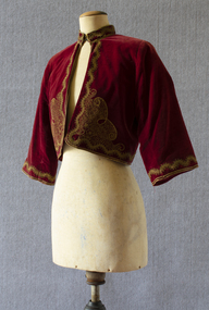
This bolero is part of a Greek national costume from the Peloponnese. Long-time Brighton resident Olga Black wore it to the 1956 Melbourne Olympic Games to represent her Greek heritage. She remembers the stands at the MCG being full of migrants wearing their traditional national costumes. Olga Maria Black was born in Melbourne in 1930, the daughter of Ithacan migrants Constantine and Toula Mavrokefalos. Constantine first emigrated to Australia in 1902, returning to Greece circa 1912-13 to serve his home country in the Balkan Wars. Toula's family had left Ithaca for Romania when she was only six months old, but she happened to be visiting the island at the very time that Constantine arrived, fresh from the war. Within three weeks they were married, and when Constantine returned to Melbourne in 1914 his new bride came with him. Constantine had trained as an accountant, but his qualifications were not recognised in Australia. Changing his surname to the Anglicised "Black", he started off working in his older brother Dionysios's cafés before going into business on his own. In 1917 he opened the Paris Residential Café at 54-56 Swanston Street, which offered both dining and accommodation. The business saw some years of success, but did not survive the Great Depression. Constantine died in 1944. Olga's mother Toula learned to sew as a child, while growing up in the Romanian village of Brila. She developed her skills making lace and embroidering items for her trousseau. Some of the linen she embroidered had been woven from flax on Ithaca by her own grandmother, Efstathia. During the Depression, when money was scarce, Toula embroidered at home, doing work for a factory in Flinders Lane. Using a cotton reel, a threepence and a sixpence she created and embroidered designs on hundreds of blouses. Olga spent her preschool days sitting at the table where her mother worked. Toula would involve Olga by allowing her to help choose the colour combinations. Toula lived with Olga in Brighton until her death in 1976. Olga inherited her mother's sewing skills. She re-invented some of Toula’s trousseau nightdresses and skilfully altered other clothing, making dresses which she wore around Brighton for many years.Red velvet bolero decrated with gold stitching and braid. Lined with red satin. Stand collar which fastens with two metal hooks and eyes. bolero, jacket, greece, ithaca, migration, olympic games, 1956 olympic games, olga black -
 Old Colonists' Association of Ballarat Inc.
Photograph - Image, Lisa Gervasoni, Ballarat Old Colonists' Association Residence - Williams Cottage, 3 Charles Anderson Grove, 13/06/2021
This home was the first cottage built by the Old Colonists' Association, and was the gift of Mr and Mrs F.J. Williams. It was completed in 1925. From the minute books: "Mr and Mrs F.J. Williams, both natives of Ballarat, offered to build a cottage on the Association's ground at Perry Park [now known as Charles Anderson Grove] something after a style of the Hassell Homes. That offer was immediately followed by another from Mr S.W.J. Clark, a member of the Council. Both offers were promptly and gratefully accepted." One of the first objectives of the Association was "to provide the shelter of a hose for those Pioneers of the Goldfields whom the reverses of fortune have deprived of the means of procuring the comforts of life in their declining years." The first home at Charles Anderson Grove was built in 1925. Before that time the Association provided relief for needy pioneers. Relief included monthly monetary payments, loads of firewood, medical assistance and distribution of Christmas bosed of groceries to deserving pensioners, and in some cases payment of burial costs. ::a) The dominant purpose of the Association is to give public benevolent relief as a charity, but providing independent living accommodation in our Retirement Village for person in need who are over 65. ::b) To raise funds by membership subscription, commercial and residential rents, donations, gifts and voluntary work, for the purpose of providing direct relief of poverty, distress, misfortune or helplessness. ::c) To maintain the important heritage and ongoing viability of the Old Colonists' Association. (Revised Rules of the Old Colonists' Association of Ballarat Inc., 2016) Mr and Mrs Fred John and Matilda Anne Williams of Melbourne made a generous donation to enable this cottage to be built. It was opened in their presence in 1925. Fred John Williams was the son of John Williams and Thomassina Whilley. Together with his brother Frank Williams, Fred Williams was the proprietor of J. Williams and Sons. The brothers took over the business when their father, John Williams, retired in January 1893. In 1918 Fred Williams left Ballarat for Melbourne, at which time he was described as someone who had ‘tried to benefit the whole of Ballarat’. He was highly involved with the Forward Ballarat Movement At the time of his death in February 1926 at Lorne F.J. Williams was a partner in the firm Williams Shoemen Pty. Ltd. By 2021 the cottage had numerous cracks and required work. These photographs are a record of the condition of the cottage at that time.Colour photograph of the interior views of Williams Cottage at The Old Colonists' Association of Ballarat Inc retirement village at 3 Charles Anderson Grove, Ballarat.old colonists' association, ballarat, ballarat old colonists' club, charles anderson grove, f.j. william, retirement village, williams cottage, fred john williams, matilda anne williams, fred williams, matilda williams, 3 charles anderson grove -
 Old Colonists' Association of Ballarat Inc.
Photograph - Image, Lisa Gervasoni, 3 Charles Anderson Grove - Williams Cottage, 13/06/2021
This home was the first cottage built by the Old Colonists' Association, and was the gift of Mr and Mrs F.J. Williams. It was completed in 1925. From the minute books: "Mr and Mrs F.J. Williams, both natives of Ballarat, offered to build a cottage on the Association's ground at Perry Park [now known as Charles Anderson Grove] something after a style of the Hassell Homes. That offer was immediately followed by another from Mr S.W.J. Clark, a member of the Council. Both offers were promptly and gratefully accepted." One of the first objectives of the Association was "to provide the shelter of a hose for those Pioneers of the Goldfields whom the reverses of fortune have deprived of the means of procuring the comforts of life in their declining years." The first home at Charles Anderson Grove was built in 1925. Before that time the Association provided relief for needy pioneers. Relief included monthly monetary payments, loads of firewood, medical assistance and distribution of Christmas bosed of groceries to deserving pensioners, and in some cases payment of burial costs. ::a) The dominant purpose of the Association is to give public benevolent relief as a charity, but providing independent living accommodation in our Retirement Village for person in need who are over 65. ::b) To raise funds by membership subscription, commercial and residential rents, donations, gifts and voluntary work, for the purpose of providing direct relief of poverty, distress, misfortune or helplessness. ::c) To maintain the important heritage and ongoing viability of the Old Colonists' Association. (Revised Rules of the Old Colonists' Association of Ballarat Inc., 2016) Mr and Mrs Fred John and Matilda Anne Williams of Melbourne made a generous donation to enable this cottage to be built. It was opened in their presence in 1925. Fred John Williams was the son of John Williams and Thomassina Whilley. Together with his brother Frank Williams, Fred Williams was the proprietor of J. Williams and Sons. The brothers took over the business when their father, John Williams, retired in January 1893. In 1918 Fred Williams left Ballarat for Melbourne, at which time he was described as someone who had ‘tried to benefit the whole of Ballarat’. He was highly involved with the Forward Ballarat Movement At the time of his death in February 1926 at Lorne F.J. Williams was a partner in the firm Williams Shoemen Pty. Ltd. By 2021 the cottage had numerous cracks and required work. These photographs are a record of the condition of the cottage at that time.Colour photograph of the exterior views of Williams Cottage at The Old Colonists' Association of Ballarat Inc retirement village at 3 Charles Anderson Grove, Ballarat.old colonists' association, ballarat, ballarat old colonists' club, charles anderson grove, f.j. william, retirement village, williams cottage, fred john williams, matilda anne williams, fred williams, matilda williams, 3 charles anderson grove -
 Old Colonists' Association of Ballarat Inc.
Photograph - Image, Lisa Gervasoni, Ballarat Old Colonists' Association Residence - Williams Cottage, 3 Charles Anderson Grove, 2021, 13/06/2021
This home was the first cottage built by the Old Colonists' Association, and was the gift of Mr and Mrs F.J. Williams. It was completed in 1925. From the minute books: "Mr and Mrs F.J. Williams, both natives of Ballarat, offered to build a cottage on the Association's ground at Perry Park [now known as Charles Anderson Grove] something after a style of the Hassell Homes. That offer was immediately followed by another from Mr S.W.J. Clark, a member of the Council. Both offers were promptly and gratefully accepted." One of the first objectives of the Association was "to provide the shelter of a hose for those Pioneers of the Goldfields whom the reverses of fortune have deprived of the means of procuring the comforts of life in their declining years." The first home at Charles Anderson Grove was built in 1925. Before that time the Association provided relief for needy pioneers. Relief included monthly monetary payments, loads of firewood, medical assistance and distribution of Christmas bosed of groceries to deserving pensioners, and in some cases payment of burial costs. ::a) The dominant purpose of the Association is to give public benevolent relief as a charity, but providing independent living accommodation in our Retirement Village for person in need who are over 65. ::b) To raise funds by membership subscription, commercial and residential rents, donations, gifts and voluntary work, for the purpose of providing direct relief of poverty, distress, misfortune or helplessness. ::c) To maintain the important heritage and ongoing viability of the Old Colonists' Association. (Revised Rules of the Old Colonists' Association of Ballarat Inc., 2016) Mr and Mrs Fred John and Matilda Anne Williams of Melbourne made a generous donation to enable this cottage to be built. It was opened in their presence in 1925. Fred John Williams was the son of John Williams and Thomassina Whilley. Together with his brother Frank Williams, Fred Williams was the proprietor of J. Williams and Sons. The brothers took over the business when their father, John Williams, retired in January 1893. In 1918 Fred Williams left Ballarat for Melbourne, at which time he was described as someone who had ‘tried to benefit the whole of Ballarat’. He was highly involved with the Forward Ballarat Movement At the time of his death in February 1926 at Lorne F.J. Williams was a partner in the firm Williams Shoemen Pty. Ltd. By 2021 the cottage had numerous cracks and required work. These photographs are a record of the condition of the cottage at that time.Colour photograph of the interior views of Williams Cottage at The Old Colonists' Association of Ballarat Inc retirement village at 3 Charles Anderson Grove, Ballarat.old colonists' association, ballarat, ballarat old colonists' club, charles anderson grove, f.j. william, retirement village, williams cottage, fred john williams, matilda anne williams, fred williams, matilda williams, 3 charles anderson grove -
 Bendigo Historical Society Inc.
Document - MERLE HALL COLLECTION: ROSALIND PARK CREATIVE VILLAGE BENDIGO PROJECT AND FINAL REPORTS, 1995
MERLE HALL COLLECTION: ROSALIND PARK CREATIVE VILLAGE BENDIGO Project and Final Reports 3858.13 PDF File 11th August 1997 - three pages From: Merle Hall, Secretary Arts Bendigo To: Mike (final Media Release probably the Bendigo Advertiser) Content: Media Release two pages and a poem read out by Mosaic Artist Maery Gabriel (Hall) 'Reflections from Rosalind Park' Date Unknown: First invitation mail-out for C.V.T. Presentation and notes. Invitations to Felicity Kingerlee, Rod, Orr, Jane Cleary, Ian Stewart (Flora Hill Secondary College), Marion Stewart (White Hills Secondary College), Marion Wright, G. Maddams (& staff), Frank Ham, Tony Morris (Astronomy chap), Trevor Tonking (Cont. Ed.), Bernard smith and others at City of Bendigo, All A.B. Committee. Included are handwritten notes. Date Unknown: Two page document entitled: Enhancing the livable environment. Document contains details of the project, aims etc. 14th March 1995 To: The Greater City of Bendigo From Arts Bendigo Content: Two pages, a formal proposal for the involvement of the City of Greater Bendigo in the Creative Village project of the V.A.C. It contains information on Background, Concept,Implementation,Expected outcomes, Summary, Appendix 1 and 2 (Examples of the work of the artist). Date Unknown From John L. Content: one page of notes on similar projects and involvement by Arts Bendigo. The title of the document is Creative Village - Enhancing the Livable Environment. 5th Septemberh 1995 To: Members of the community who contributed ideas and suggestions From Arts Bendigo Ann Buzza and Merle Hall. Content: Invitation to attend a meeting with the Creative Village Team to view the Team's full report and explanation of designs etc. 9-10 June To: Participants in the Maery Hall Workshop From Arts Bendigo Ann Buzza and Merle Hall. Content: Location - ceramic department, Fine Arts building, Latrobe University Bendigo; acces information and what to bring to the workshop. Date Unknown To: City of Greater Bendigo Content: Arts Bendigo committment to the guidelines discussed with the relevent Council officers. Date Unknown To: City of Greater Bendigo From Arts Bendigo Content: Title - Historic Mining Mosaic Pavement at rosalind Park Poppet Head. A report on the project so far. Typed and ewritten notes. 28 July To: Public From Arts Bendigo Merle Hall. Content: Public invite to mark the completion of the project. June 1997 To: Public Content: A copy of Bendigo Heritage Mosaic City of Greater Bendigo plaque. 2nd September To: Attention Leanne McDonnell, Bendigo Advertiser From Arts Bendigo Merle Hall. Content: Media Release on 'The Laying Begins' Date Unknown To: Potential Donors From Arts Bendigo Merle Hall, sponsorship committee. Content: Description of the project titled 'Exciting Addition to Bendigo's Central Area. Date Unknown To: Potential Donors From Arts Bendigo Merle Hall, sponsorship committee. Content: Description of the project titled 'Exciting Addition to Bendigo's Central Area. Date Unknown List of LEAP team members for the project. Date Unknown To: Emma Power From Arts Bendigo Secretary Merle Hall. Content: three pages of information on the project (1. Intoduction 2. Small leaflet, prepared for visitors to the team 3. General outline of the project and the background on the Creative Village Team. 19-21 July To: All schools of the Bendigo area From: Merle Hall Secretary Arts Bendigo Content: An invitation for staff and students to visit the Creative Village Team during their time in Bendigo, at the Central Library on 19-21 July 19-21 July To: The Public From: Merle Hall Secretary Arts Bendigo Content: An invitation for staff and students to visit the Creative Village Team during their time in Bendigo, at the Central Library on 19-21 July 5th October 1995 To: Mr Peter Seamer, Chief Executive Officer, City of Greater Bendigo. From Merle Hall Secretary Arts Bendigo Content: RE 'Creative village team report and ongoing plans' 14 March 1996 To: Committee of Arts Bendigo From: Ann Buzza Content: Two pages hand-written report on visit of Maery Hall ot Bendigo 14/3/96 Date Unknown To: Bernard Smith, City ogf Greater Bendigo From: Merle Hall, Secretary Arts Bendigo Content: A list of urgent requirements needed by May 24th, material list from council stock. 27 June 1996 To: The Professionals, 54 Mitchell Street Bendigo, Attention Stephen Carter From: Merle Hall, Secretary Arts Bendigo Content: Account for use of shop in Allan's walk and cheque. 2nd July 1996 To: Cr Megan Weston Mayor, city of Greater Bendigo, copy to Bernard Smith. From: Merle Hall, Secretary Arts Bendigo Content: Thank you for $3500 to match the Arts Bendigo sponsorship. 2 June 1996 To: James C donnelly and associates, 5 School Lane, Wangi Wangi. From: Merle Hall, Secretary Arts Bendigo Content: Draft cover letter including a one page draft letter and a two page submission. James Donnelly was a parent of one of the LEAP workers who were helping on the project. James donnelly had suggestions for approaching mining companys for potential sponsorship. 1st October 1996 To: Mr D. Goldsworthy, City of Greater Bendigo From: Merle Hall, Secretary Arts Bendigo Content: Historic mining Mosaic Project, Rosalind Park Poppet Head. A formal submission for the council for some essential provisions for the extension of work on this project. 1st October 1996 To: Cr M. Weston, Mayor, City of Greater Bendigo. From: Merle Hall, secretary arts Bendigo Content: Three pages including a listing of income and costs to the project. 28th October 1996 To: Arts Bendigo From: Maery Hall Artist Content: two page report on the status of the project and problems that have been faced. 19th To: Leanne (maybe the Bendigo Advertiser) From: Merle Hall, secretary arts Bendigo Content: two pages on the finished project (Bendigo's Newest attraction) 19th March 1997 To: Steve From: Merle Hall, secretary arts Bendigo Content: Asking for rough quotes for printing of brochures. Date Unknown To: The Bendigo Bank From: Merle Hall, secretary arts Bendigo Content: two pages seeking a sum of $1000 to complete the project. 28th April 1997 To: Suzi Birthisel, Sponsorship Coordinator, Bendigo bank, Fountain Court, Bendigo From: Merle Hall, secretary arts Bendigo Content: Asking for a small sum for production of coloured brochures Date Unknown To: Committee From: Merle Hall, secretary arts Bendigo Content: Suggested invitation list from 'Arts Victoria' to the Committee re the opening on 28th July of the Bendigo Heritage Mosaic. 28 July 1997 From: City of Greater Bendigo and Arts Bendigo to public Content: Invitation to a brief ceremony to mark the occasion of the completion of The Bendigo Heritage Mosaic at the Poppet Head Lookout, Rosalind Park on Monday 28 July 1997. 5th August 1999 From: Merle Hall, Secretary Arts Bendigo To: Cr. B. Ackerman, Mayor, City of Greater Bendigo. Content: A brief note from the committee of Arts Bendigo, in appreciation of your attendance and speech at the 'completion ceremony, last week. 30th October 1997 From Merle Hall, Secretary Arts Bendigo To: the National Community links Awards, Category 1 - Arts and Culture Content: Included were Nomination Form, Written Statement as required under (5), a written reference from the mayor of the City of Greater Bendigo, two pages of photographs of the project, and five copies of a brochure printed to publicise the project. 2nd Feb 1998 From Merle Hall, Secretary Arts Bendigo To: Mrs. S. Parain, President, Regional Arts Fund Content: Regional Arts Fund Application, Sections 1 to 4 requesting a grant of $5197.00 -
 Eltham District Historical Society Inc
Photograph - Digital Photograph, Alan King, Great Hall, Montsalvat, 8 January 2008
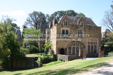
Great Hall at Montsalvat built 1938-52, designed by Justus Jorgensen Covered under National Estate, National Trust of Australia (Victoria) State Significance, Victorian Heritage and Heritage Overlay, Nillumbik Planning Scheme. Published: Nillumbik Now and Then / Marguerite Marshall 2008; photographs Alan King with Marguerite Marshall.; p129 At first glance, Montsalvat, the artists’ community at Hillcrest Avenue, Eltham, could belong to another time and place. The French provincial Gothic-style buildings blend picturesquely with the introduced and native trees and farm animals on the five hectare property. But Montsalvat belongs very much to today’s Eltham, having inspired much of its creative activity and style. The use of mud-brick and recycled building materials, for which Eltham is so well-known, was largely popularised by Montsalvat. Montsalvat – unique in Victoria and probably in Australia – is registered by the National Trust and National Estate.1 Montsalvat, named after the castle of the Knights of the Holy Grail, has attracted artists and intellectuals since it was founded in 1934. For years at weekends, artists, lawyers, philosophers, politicians and others, who shared a love for what Montsalvat stood for, gathered for a meal and stimulating discussion. The focus for this gathering of talent was Justus Jörgensen, an eccentric man with vision and charisma. It was Jörgensen’s foresight that saw the creation of Montsalvat, which in 1975 was formed into a trust to benefit the Victorian people. The property was then valued at about three million dollars. It is now visited by thousands of people annually. Born in 1894 and brought up a Catholic, Jörgensen had trained as an architect. He later studied painting at the National Gallery School under artist, Frederick McCubbin, then joined the studio of artist Max Meldrum. In 1924, Jörgensen married medical student Lillian Smith, and with artist friends they travelled to Europe to study the great masters. In London Jörgensen exhibited in several major galleries. One of his still life paintings was included in the book The Art of Still Life by Herbert Furst, which featured 100 of the greatest ever still life paintings.2 In 1929, Jörgensen returned to Melbourne where Lil, now qualified, worked as an anaesthetist at St Vincent’s Hospital. They bought a small house in Brighton and Jörgensen rented a large building in Queen Street for his studio until the Royal Automobile Club of Victoria bought it in 1955. While designing and overseeing the building of a studio for his friend the famous cartoonist Percy Leason, in Lavender Park Road, Jörgensen decided to buy land for a country retreat in Eltham. So the building of Montsalvat began. Jörgensen gathered around a dozen of his friends and students from his Queen Street studio. They set to work, first at weekends then some decided to live permanently on the site. Jörgensen had seen mud-brick buildings in Spain and recognised that Eltham’s clay soil was ideal for mud-bricks and although labour intensive, it was a very cheap way of building. Jörgensen’s students and friends worked under his direction with the help of local tradesmen, including carpenter, Len Jarrold and later stone mason, Horrie Judd. In return Jörgensen would give the students a painting lesson or two. It was the Great Depression when many were out of work. Jörgensen also inspired people to give generously of money and materials. With their help Jörgensen found second-hand materials for building. Friends donated slate for roofing, discarded firebricks were used for flooring and windows and doors and a cast-iron circular staircase came from a wrecker. The students’ day started at 7am with building and domestic chores, shared equally between the sexes. The first building was used by his friends at weekends and then became a home for his wife Lil. It consisted of three rooms and an attic under a high-pitched roof. Jörgensen then built a similar structure with the same high-pitched roof as a more permanent home for his students. The two buildings were joined together with a tower and a studio for Jörgensen. While excavating for the studio a reef of yellow mud-stone was found and then used in construction. The next building was the Great Hall, to be used for dining, exhibitions and meetings and completed in 1958, after a halt during the war. Whelan the Wrecker donated the stone-framed windows from the building that housed the Victorian Insurance Co. in Collins Street, which had been demolished in the 1930s. The swimming pool was donated and cubicles were built for the students with their initials marked in tiles on each doorstep.1 One of Jörgensen’s great abilities was to recognise how to use material which harmonised. He would comb through wreckers’ yards for what he needed. Regarding his buildings as sculptural pieces, his first consideration was for the aesthetic quality of a building and only then for its functionality.2 At Montsalvat, Jörgensen found he was able to put his ideas into practice without compromise and those who worked with him had to conform to his ideas. With the Jörgensens, the colony’s original nucleus consisted of the Skipper family – Mervyn and wife Lena, daughters Helen and Sonia and son Matcham,who was to become an eminent jeweller and sculptor represented in National Gallery collections throughout Australia and in European museums.3 Other members were Arthur Munday, Lesley Sinclair, Helen Lempriere, Ian Robertson, John Smith, George Chalmers, John Busst and Sue Van der Kellan; also Jörgensen’s three sons – Max, Sebastian and Sigmund – and Saskia, Sonia Skipper and Arthur Munday’s daughter. Montsalvat went through some hard times when local gossips spread rumours of sexual shenanigans at Montsalvat. However Montsalvat also had many local supporters – especially amongst the local tradespeople. The colony was certainly unconventional – with Jörgensen’s wife Lil (and son Max) and life-time partner Helen Skipper, (mother of Sebastian and Sigmund) living at Montsalvat. Sonia Skipper says in her biography that the group were ‘very conscious of their responsibilities to each other and a desire to make their relationships work’.4 By World War Two many buildings around the Great Hall were completed. Jörgensen was a pacifist, as were most of his students. Some of the Montsalvat community enlisted while others engaged in essential services like dairy farming and market gardening for the war effort. It was then that Jörgensen constructed farm buildings. After the war many well-known personalities such as Clifton Pugh, landscape gardener Gordon Ford, and builder Alistair Knox, were drawn to Montsalvat. They learnt that building was not a ‘sacred cow’ only for professionals, but that anyone who was willing to get their hands dirty could do it. The post-war shortage of materials also encouraged builders to follow Montsalvat’s lead in reusing materials. When Jörgensen died in 1975, his influence did not – thanks largely to the vigilance of his son, Sigmund, who became its administrator. The weekend dinners have gone, but in 2008 about 14 artists still work at Montsalvat – some living there – including a couple who have been there since its early days. Under Sigmund’s direction Montsalvat further expanded its activities which included festivals, art exhibitions, concerts and weddings. Sigmund completed the Chapel, then the Long Gallery next to the pool, After the barn burnt down, he replaced it in 1999 (the builder was Hamish Knox, Alistair’s son) with a new gallery and entrance and added a restaurant. Sigmund has been careful that any new building blends in with the character of Montsalvat. In 2006 Montsalvat was restructured for its continued financial viability and with the help of Arts Victoria a new executive officer was appointed. A representative board from the wider community was established, which includes members from the former Montsalvat Trust including Sigmund Jörgensen – who is now the heritage and arts adviser to the new company Montsalvat Ltd.5 Today, visiting Montsalvat one still sees artists, students and visitors enjoying the unique and beautiful surroundings.This collection of almost 130 photos about places and people within the Shire of Nillumbik, an urban and rural municipality in Melbourne's north, contributes to an understanding of the history of the Shire. Published in 2008 immediately prior to the Black Saturday bushfires of February 7, 2009, it documents sites that were impacted, and in some cases destroyed by the fires. It includes photographs taken especially for the publication, creating a unique time capsule representing the Shire in the early 21st century. It remains the most recent comprehenesive publication devoted to the Shire's history connecting local residents to the past. nillumbik now and then (marshall-king) collection, eltham, great hall, montsalvat -
 Federation University Historical Collection
Book - Scrapbook, Mining articles and notices, 1932 - 1936, 1934-1936
Hardcover minute book with charcoal green cover and red spine. Numerous newspaper clipping have been pasted onto the pages, most related to mining. The clippings include: 26 September 1932 - Castlemaine Goldmines - Best Prospects for Years 12 October 1932 - South New Chum Syncline Goldmines NL 30 November 1932 - New Morning Star Co. 19 February 1934 - Berringa Gold Syndicate NL 12 September 1934 - Murchison Goldfield - Triton Gold Mine 1935 - Great Poseidon 1935 1935 - Golden Age Amalgamated 11 February 1935 - Loloma Gold Mines NL 19 May 1936 - Beaconsfield Gold Mine in Tasmania 02 July 1936 - Fletchers Gold Mine 17 August 1936 - Lasseter's Reef. Kalgoorlie 17 November 1836 - Large Scale Operations at Ballarat 16 January 1937 - New Charlton Gold Area 19 January 1937 Golden Jacket Mine 26 January 1937 - Rich Quartz at Avoca April 1934 - Bendigo Mines Limited May 1934 - Church Centenary - St Luke's Campbell Town Interesting History (image) Tasmania 1932 - Evolution of Auto-Car - Cugnot's Steam Trolley (image) 1932 - Evolution of Auto-Car - Push Foot Schemes (image) 1933 - Evolution of Auto-Car - Hancock's Steam Omnibus (image) 1933 - Evolution of Auto-Car - First Petrol Car (image) 1934 - The Gold Standard - How Australia Forsook It August 1934 - Bolwarrah and Gordon's Amalgamated NL 23 August 1934 - Dunolly Gold Mines NL 12 September 1934 - Murchison Goldfield - Triton Gold Mine 08 September, Adelaide Advertiser - Australia's Heritage of Golden Days by Ernestine Hill 28 November 1934 - Chronicles of Early Melbourne by Garyowen 05 May 1936 - Bendigo Mines Director's Policy (image of E.C. Dyason) 30 June 1936 - Lamplough Mine 27 June 1936 - Gold Dredging Company for Newstead 30 May 1935, The Herald - Gordon Battery in Production 19 September 1936 - Wattle Gully reef - Payable Values at 655 Feet 30 June 1936 - Avoca Developments NL 16 July 1934 - Westralia Renown Mines NL Prospectus 07 November 1936 - Ballarat East Gold Field - English Company's Deal (Victoria United, Britania United, First Chance, Last Chance, Llanberris No 1, Llanberris No 2, Sulieman No. 1, Sulieman No. 2, Sulieman No. 4, North Normanby, North Woah Hawp, Woah Hawp Canton, Tinworth's, Prince Regent Consolidated) 07 November 1936 - Large Scale Operations at Ballarat (image of A.E. Llewellyn) * How an Australian Discovered the World's Greatest Goldfield -The Beginning of The Rand. bendigo mines, coolgardie discovery, melbourne - chronicles of early melbourne, ballarat gold field, mining, lasseter's reef, squatter, emperor mine, cassilis gold mining, granite, bendigo mines ltd, campbell town st luke's centenary, car evolution, dartmore, harcourt granite, murchison goldfield, ballarat mines, fanny bay, mail, rand, alex allan, raymond cahalin, mary dyer, robert fordham, a. garsand, augustus f. heseltine, j. owen james, william latham, k palmer, tinworth, theosanous, c. tompkin, castlemaine goldmines, coolgardie -
 The Beechworth Burke Museum
Photograph - Lantern Slide, c1900
This lantern slide shows the Ovens District Hospital (also called the Ovens Goldfields Hospital) in Beechworth in approximately 1900. The Hospital was built as part of a community push to develop the infrastructure needed for a permanent town in the 1850s. At the time there was no hospital located between Melbourne and the NSW town of Goulburn and it was recognised that the nature of mining and agricultural work predisposed people to serious injury. The community voted in 1853 to raise funds for a hospital and a voluntary committee elected from people who contributed £2 or more annually determined the organisation's management policies, which aimed to provide care for poor people at rates levied according to the person's means. Ongoing operations of the hospital were primarily supported by Government grants, however. The foundation stone was laid at a site in Church Street at a ceremony held 1st September 1856 which was attended by 2000 people using a locally crafted trowel with a tin ore handle and pure gold blade. The hospital, which was designed by J.H. Dobbyn, cost £2347. The hospital had two wards, a dispensary, apartments for a resident surgeon and the matron, an operating theatre and a board room. Further medical facilities including services to meet the cultural and health needs of the local Chinese community were later added, in addition to a Palladian-style cut-granite face built in 1862-63. It functioned as the region's primary hospital until surpassed by the Wangaratta Hospital in 1910. In the 1940s much of the building materials were salvaged and repurposed, with the exception of the facade which was restored in 1963 by the Beechworth Lions Club and still stands today. The facade featured on the covers of local history volume 'Beechworth: a Titan's Field' by Carole Woods and heritage-focused travel guide the 'Readers Digest Book of Historic Australian Towns'. Lantern slides, sometimes called 'magic lantern' slides, are glass plates on which an image has been secured for the purpose of projection. Glass slides were etched or hand-painted for this purpose from the Eighteenth Century but the process became more popular and accessible to the public with the development of photographic-emulsion slides used with a 'Magic Lantern' device in the mid-Nineteenth Century. Photographic lantern slides comprise a double-negative emulsion layer (forming a positive image) between thin glass plates that are bound together. A number of processes existed to form and bind the emulsion layer to the base plate, including the albumen, wet plate collodion, gelatine dry plate and woodburytype techniques. Lantern slides and magic lantern technologies are seen as foundational precursors to the development of modern photography and film-making techniques.This glass slide is significant because it provides insight into Beechworth's built environment and infrastructure in the early Twentieth Century, around the time of Australia's Federation. It is also an example of an early photographic and film-making technology in use in regional Victoria in the time period.Thin translucent sheet of glass with a round-edged square image printed on the front and framed in a black backing. It is held together by metal strips to secure the edges of the slide.Obverse: Y /burke museum, beechworth, lantern slide, slide, glass slide, plate, burke museum collection, photograph, monochrome, ovens district hospital, indigo shire, north-east victoria, hospital, palladian architecture, granite, community fundraising, community infrastructure, j.h. dobbyn, beechworth lions club, ovens goldfields hospital, chinese community -
 The Beechworth Burke Museum
Photograph - Photograph - Reproduction, Unknown
This image is a reproduction of an 1899 original depicting the 'Williams Good Luck Mine' on the Mopoke Reef (also called 'Morepork Gully') in the Dingle Ranges, approximately three miles from Beechworth. The foreground of the image is littered with piles of smashed rock and detritus, known as ‘mullock’, beside a reinforced mine shaft, a vertical access passageway allowing miners to enter the mine and haul ore out using lifting technology such as a poppet heads, whims or windlasses. A group of miners and a dog appear close to an open-sided miner’s hut. Following the discovery of gold at Beechworth in 1852, rushes quickly followed at surrounding creeks and gullies in the district. In the late nineteenth and early twentieth centuries, small syndicates of miners continued to work old or abandoned quartz reefs, often persisting without the assistance of heavy machinery to remove the large amounts of rock, in order to obtain yields at ever greater depths. The group of miners in this photograph are Mr. Roger Williams and Sons, who revived operations at the ‘Old Good Luck’ mine on the Mopoke Reef in the Dingle Range near Beechworth around 1892, working the site for more than two decades. An emigrant from Cornwall with experience in the tin mining industry, 19 year old Roger Williams senior sailed to New Zealand in 1840, then to Australia where he spent time in the Bendigo Gold Fields before settling in Beechworth in the early 1860s. Mr Williams senior worked on various mining activities in the district, including the Rocky Mountain Tunnel project. Conversant with the character of gold-bearing reefs in the area, the syndicate dug an eight hundred foot tunnel, digging down as far down as two hundred feet with little capital save their labour, to connect and provide better working access to the mass of reefs and veins in the vicinity. Progress was hampered by poor air quality charged with fumes from dynamite and large quantities of rock had to be crushed to obtain payable yields. The Victorian Goldfields are filled with ruins and remnants of the area's rich mining history, ranging from small alluvial diggings to the remains of huge mining companies. Site names often changed several times throughout the nineteenth and twentieth centuries. Some sites were abandoned and forgotten, others were worked continuously over many decades. The names of mines were often repeated at different locations throughout the Victorian Goldfields. For example, there is a Mopoke Gully heritage mine near Fryers Creek, Victoria. 'Mopoke' is a common onomatopoeic name for Morepork and Australian Boobook owls. This image has historical, social and research significance for patterns of emigration during of the Victorian Gold Rush, and the historical, social and environmental impacts of mining at Beechworth at the turn of the nineteenth and twentieth centuries. As gold became scarce and government support and large company investment waned, poor hard-working miners laboured intensively to make a living through periods of high unemployment. This image can be compared and studied alongside other historical mining photographs and objects in the Burke Museum Collection. It has potential to improve our understanding of miners working conditions and the shifting character of mining in the Beechworth district. Black and white rectangular reproduction photograph printed on matte photographic paper.Obverse: Williams Good Luck Mine Beechworth / Roger! / Reverse: 6858 / burke museum, beechworth museum, beechworth, gold fields, gold rush, victorian gold rush, gold ming history, colonial australia, australian gold rushes, mining technology, beechworth historic district, indigo gold trail, migration, indigo shire, good luck gold mine, victorian goldfields, mining syndicates, gold fever, quartz-mining, small-scale mining, old good luck mine, mopoke gully, quartz reefs beechworth -
 Eltham District Historical Society Inc
Photograph - Digital Photograph, Alan King, Former bootmaker's shop, Main Road Eltham, 29 January 2008
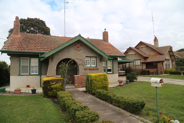
The former bootmaker's shop is one of only three remaining original shops from the early 20th century in what was once Little Eltham, the others being the present day Cafe Zen-Den at 736 Main Road and the former Burgoyne General Store and Post Office, present-day San Antonio Barbershop at 820 Main Road. Jarrold Cottage or White Cloud is known by many to be associated with the Skipper family, and has been since 1944 when Lena Skipper, wife of Mervyn Skipper purchased the cottage. She purchased it from the Estate of Thekla Jarrold who had died in March of the previous year. By the time Thekla died, she had lived in the Jarrold Cottage for 50 years. Thekla Alvenia Sissilia Ellian married John William Jarrold in 1888 at Clifton Hill. They started their family there but when John’s father William (who was married to Hannah Coleman) died in 1893 the family moved to Eltham. William had married Hannah Coleman in 1856 at his home in Eltham. William had arrived in the colony in 1848 so it is believed the Jarrold Cottage goes back at least to 1856 and possibly early 1850s. For a short period of time the cottage was rented to the Police as a temporary Police Station whilst a new and more permanent station was built further up the hill in 1859. The cottage was originally located closer to the Diamond Creek but was subject to flooding so was relocated to its present position on top a mound of rubble placed there from the nearby quarry next to the Dalton Street school (on Main Road). By 1916, John Henry Clark, a photographer who took many early photos of Eltham relocated from Fitzroy to Eltham and boarded with recently widowed Thekla Jarrold and her family. He changed professions from photographer to boot and harness maker around 1931 and Thekla had a small bootmakers shop built ifor him in the corner of her property next to the family home. J.H. Clark remained living at the property until his death in December 1956. At some stage after Clark's death, Lena Skipper is recorded living at the property having relocated from Montsalvat following the death of her husband Mervyn. The property continues to remain within the Skipper family as of 2023. Covered under Heritage Overlay, Nillumbik Planning Scheme. Published: Nillumbik Now and Then / Marguerite Marshall 2008; photographs Alan King with Marguerite Marshall.; p47This collection of almost 130 photos about places and people within the Shire of Nillumbik, an urban and rural municipality in Melbourne's north, contributes to an understanding of the history of the Shire. Published in 2008 immediately prior to the Black Saturday bushfires of February 7, 2009, it documents sites that were impacted, and in some cases destroyed by the fires. It includes photographs taken especially for the publication, creating a unique time capsule representing the Shire in the early 21st century. It remains the most recent comprehenesive publication devoted to the Shire's history connecting local residents to the past. nillumbik now and then (marshall-king) collection, bootmaker's shop, jarrold cottage, john henry clark, lena skipper, thekla alvenia sissilia jarrold (nee ellian), white cloud cottage, shops -
 Eltham District Historical Society Inc
Photograph, Peter Pidgeon, White Cloud Cottage, 701 Main Road, Eltham, 2 Aug. 2022
Jarrold Cottage built c.1853, also known as 'White Cloud", located at 701 Main Road, Eltham, opposite Dalton Street. The house remains intact and is listed on the Victorian Heritage Database and considered historically significant to the Shire of Nillumbik. The cottage was originally located closer to the Diamond Creek but was subject to flooding. It was dragged by horse to the present site shown, which was chosen for the higher ground that had been created as a result of land fill being deposited here from the quarry further around the bend on Main Road (site of present-day Eltham Primary School carpark) where the stone had been quarried for building the State School in Dalton Street. It had previously been rented for use as a Police Station / residence prior to the building of the permanent police house and station at the corner of Maria and Brougham streets in 1859. The cottage was purchased by Lena Skipper after the death of Thekla Jarrold in 1943 and remains in the family to present day (2022). Comparison photo: SEPP_0749 Part of a presentation by Peter Pidgeon to the Society, 13 August 2022 showcasing a series of photographs taken by John Henry Clark over the period 1895 to 1930. John Henry Clark was the youngest of three boys born to William Henry Clark (1823-1877) and Maria White (1843-1914). He and his brothers, William Charles Clark (1872-1945), Clement Kent Clark (1874-1912) operated a photography business (Clark Bros.) from 25 Thomas Street, Windsor near Prahran during the period c.1894 to 1914. Following death of Clement in September 1912 and their mother in 1914, the Clark Bros business appears to have dissolved, the premises demolished, and a new house was under construction in 1915. John set up business independently in 1914 operating out of 29 Moor Street, Fitzroy where he is registered in the 1914 and 1915 Electoral Rolls. By 1916 John had relocated to Eltham where he continued his practice as a photographer and took many of the early images around the district of Little Eltham. Around 1930 John changed professions and opened a small cobbler's shop in 1931 near the pond opposite Dalton Street adjacent to the Jarrold family cottage. He never married and continued his profession as a bootmaker from this little shop, maintaining a close relationship with Mrs Jarrold for the rest of their lives. His bootmaker shop remains today beside the Whitecloud cottage and is one of only three remaining shops in the area from the early 20th century.Comparative photo taken 2022 with one taken from same location over 100 years earlier by noted local photographer J.H. ClarkBorn Digitaleltham, j.h. clark photo (2022), dalton street, main road, bootmaker's shop, jarrold cottage, white cloud cottage, avenue of honour -
 Eltham District Historical Society Inc
Photograph, View looking up 'Policeman's Hill' on Main Road from Dalton Street showing Police Residence, c.1906, 2010c
For original image see EDHS_00533 This photo was originally mounted on 3mm MDF fibre board with notes and stickers applied as part of a display on the former Police Residence and now present day Local History Centre, home to Eltham District Historical Society; possibly put together by Harry Gilham during his time as president of the society. Eltham Police Station and Residence: A brief history 1860 Eltham Courthouse built in Main Road, together with an adjoining police residence, office, lock–up and stables. 1959 Police Department purchases a house in Pryor Street to be refurbished as Eltham Police Station 1961 Police in Eltham move into Pryor Street refurbished buildings and office. c.1961-1981 Occupied by Vermin and Noxious Weeds Destruction Section of the Department of Crown Lands and Survey. Former Police Station dragged around to rear of Police Residence (prior to August 1967) to make way for the construction of a driveway and access from Main Road. The building was placed on the site of a former Scullery and modified for Lands Department use. 1981 Shire of Eltham take over management of old Police Residence in Eltham. It remains unoccupied for a period of time whilst its future is discussed in Council. 1981-1985 Used for community job creation scheme 1985 Shire of Eltham Parks and Environment occupy the residence. Council improve the driveway but later add a second rear access from Brougham Street due to the dangerous nature of the Main Road entrance. Also add a rear toilet facility between the Police Residence and former Police Station, which was doubling up as a lunch room. Council also commence discussions to re-establish a replica Police Station. c.1986 November. Former Police Station demolished; believed to have been suffering termite damage. c.1989 After some years of discussion a replica Police Station is built, based on photographs, to act as a lunch room and meeting room for Parks and Environment staff and volunteers doing community service. 1996 Eltham District Historical Society in discussions with Nillumbik Shire Council commisioners throughout the year regarding a home for the Society. A proposal put forward by the Society in October to occupy the former Police Residence. 1997 March. Eltham District Historical Society gains access to former Police Residence. 1998 July 12th. Eltham District Historical Society Inc moves into its Local History Centre, 728 Main Road Eltham (the former Police Residnce built in 1860). 2018 July. Eltham District Historical Society gains access to the replica Police Station for use as part of regular heritage tours for schools and community based groups.Black and white photocopyLabels and handwriting in pencil and ink identifying various buildings. Also highlighted is the acetylene gas lamp and on reverse is written "Lamplighter Jimm Saville"728 main road, eltham, local history centre, parks and environment, police residence, police station, shire of eltham -
 Flagstaff Hill Maritime Museum and Village
Container - Earthenware jar, Bailey & Co, circa 1878
The handmade earthenware jar was one of a group of artefacts in the McCulloch Collection that were recovered from the shipwreck Loch Ard. The jar could have been from the ship's cargo or personal effects. There are other jars in our collection that were recovered from the Loch Ard. The object is now one of the shipwreck artefacts in Flagstaff Hill’s Mc Culloch Collection, which includes items recovered from the wrecks of the Victoria Tower (wrecked in 1869) and Loch Ard (wrecked in 1878). They were salvaged by a diver in the early 1970s from the southwest coast of Victoria. Advanced marine technology had enabled divers to explore the depths of the ocean and gather its treasures before protective legislation was introduced by the Government. The artefacts were donated to Queensland’s Department of Environment and Heritage Protection (EHP) by a passionate shipwreck lover and their locations were verified by Bruce McCulloch. In 2017 the Department repatriated them to Flagstaff Hill where they joined our vast collection of artefacts from Victoria’s Shipwreck Coast. The Loch Ard: - The three-masted, square-rigged iron ship Loch Ard belonged to the famous Loch Line which sailed many ships from England to Australia. The ship was built in Glasgow in 1873. The Loch Ard made three trips to Australia and one trip to Calcutta before its final voyage. The Loch Ard left England on March 2, 1878, under the command of Captain Gibbs, bound for Melbourne with a crew of 37, plus 17 passengers and a load of cargo. The general cargo included straw hats, umbrellas, perfumes, clay pipes, pianos, clocks, confectionery, linen and candles, as well as a heavier load of railway irons, cement, lead and copper. There were items included that were intended for display in the 1880 Melbourne International Exhibition, including the famous Loch Ard Peacock. On June 1, 1878, Captain Gibbs was expecting to see land but visibility was reduced by fog. As it lifted, the sheer cliffs of Victoria's west coast came much closer than expected. The captain was unable to steer away and the ship struck a reef at the base of Mutton Bird Island, near Port Campbell. The top deck was loosened from the hull, the masts and rigging came down and knocked passengers and crew overboard, and even the lifeboat crashed into the side of the ship and capsized. Of the 54 people on board, only two survived: the apprentice, Tom Pearce and the young woman passenger, Eva Carmichael. The well-packed Minton porcelain peacock also survived, safe inside its crate. Much of the cargo was washed up, smashed and broken, and some was salvaged. Other cargo is still with the wreck at the base of Mutton Bird Island, now protected by Government law. The artefact is an example of cargo or personal items on board a ship in 1878. It provides a reference point for classifying and dating similar items. This artefact is significant for its association with the sailing ship Loch Ard, one of the best-known, and one of the worst, shipwrecks in Victoria’s history. Flagstaff Hill’s collection of artefacts from Loch Ard is significant for being one of the largest collections of artefacts from this shipwreck in Victoria. It is significant for its association with the shipwreck, which is on the Victorian Heritage Register (VHR S417). The collection is significant because of the relationship between the objects, as together they have a high potential to interpret the story of the Loch Ard. The Loch Ard collection is archaeologically significant as the remains of a large international passenger and cargo ship. It is historically significant for representing aspects of Victoria’s shipping history. Container, round brown earthenware jar with a wide mouth, thick lip, a wide neck that tapers slightly inwards towards the shoulder, and a body that tapers slightly inward towards the base. The glazed surface is rough. The variegated colours of the clay also has small dark speckles. There are several chips and dents on the jar. The inscription is stamped into the lower edge. Made by Bailey & Co., England. Recovered from the wreck of the Loch Ard.Inscription “Bailey [&] Co / ENGLAND” flagstaff hill, warrnambool, flagstaff hill maritime museum, maritime museum, shipwreck coast, flagstaff hill maritime village, great ocean road, white star line, victorian heritage register, sailing ship loch ard, loch line, loch ard, captain gibbs, eva carmichael, tom pearce, glenample station, mutton bird island, loch ard gorge, migrant ship 1878, cargo ship 1878, stoneware jar, domestic container, kitchenware, kitchen storage, bailey & co england, shipwreck artefact, wreck dive, mcculloch collection, bruce mcculloch, 1878, sailing ship, earthenware, stoneware, domestic jar -
 Flagstaff Hill Maritime Museum and Village
badge - Presbyterian Brotherhood badge, 1920s to 1940s
This badge is one of a set of badges collected by Dr W R Angus from the organisations in which he was involved. The set of badges is now part of Flagstaff Hill’s comprehensive W.R. Angus Collection, donated by the family of Dr W R Angus, surgeon and oculist. The badge represents the Australian Presbyterian Brotherhood. The Presbyterian church has used the burning bush logo from the 1800s. The logo describes the Biblical account of the prophet Moses, who saw the miracle of a bush on fire that did not burn and heard the voice of God giving his instructions. The light blue cross symbolises the origin of the Australian Presbyterian church, the Church of Scotland, which is Presbyterian. Its flag is blue with a white 'x' and a burning bush symbol in the centre. Dr William Roy Angus was of Scottish heritage. He sailed overseas to further his studies at Edinburgh Royal Infirmary and in 1928, was awarded FRCS (Fellow from the Royal College of Surgeons), Edinburgh, Scotland. He was e Presbyterian and treated Sunday as a Sabbath, a day of rest. He would visit three or four country patients on a Sunday, taking his children along ‘for the ride’ and visiting with him. Sunday evenings he would play the pianola and sing Scottish songs to his family. In 1928, Dr Angus was a Flying Doctor in the A.I.M. (Australian Inland Ministry) Aerial Medical Service, which was established by the Presbyterian Church in that year. The W.R. Angus Collection includes historical medical equipment, surgical instruments and material belonging to Dr Edward Ryan and Dr Thomas Francis Ryan, (both of Nhill, Victoria) and Dr Angus’ own belongings. The Collection’s history spans the medical practices of the two Doctors Ryan, from 1885-1926 plus that of Dr Angus, up until 1969. It includes historical medical and surgical equipment and instruments from the doctors Edward and Thomas Ryan of Nhill, Victoria. Dr Angus married Gladys in 1927 at Ballarat, the nearest big city to Nhill where he began as a Medical Assistant. He was also Acting House surgeon at the Nhill hospital where their two daughters were born. During World War II He served as a Military Doctor in the Australian Defence Forces. Dr Angus and his family moved to Warrnambool in 1939, where Dr Angus operated his own medical practice. He later added the part-time Port Medical Officer responsibility and was the last person appointed to that position. Both Dr Angus and his wife were very involved in the local community, including the planning stages of the new Flagstaff Hill and the layout of the gardens there. Dr Angus passed away in March 1970.This badge is significant for connecting Doctor Angus with organisations that he supported. The badge also associates Dr Angus with the history of the Presbyterian Church in Australia, showing the historic logo of the burning bush and the Scottish flag. The W.R. Angus Collection is significant for still being located at the site it is connected with, Doctor Angus being the last Port Medical Officer in Warrnambool. The Collection includes historical medical objects that date back to the late 1800s.Badge; a round badge with a blue enamel outer border in front of a light blue enamel ‘x’. A silver logo is on top of the 'X'. There is a silver inscription around the outer circle. It is the badge of the Presbyterian Brotherhood of Australia.This badge is part of a set of badges collected by Dr W R Angus. the set represents organisations that he was involved in, and is part of the W.R. Angus Collection.On the dark blue border: “PRESBYTERIAN BROTHERHOOD’ Logo [a bush on fire] a 'burning bush'flagstaff hill, warrnambool, maritime village, maritime museum, shipwreck coast, great ocean road, w.r. angus, badge, organisation badge, flagstaff hill maritime museum and village, badges, buttons, lapel badge, religious badge, denominational badge, presbyterian church, presbyterian brotherhood, hat pin, flying doctor, scottish heritage, w.r. angus collection -
 Glen Eira Historical Society
Album - Album page, Bureel (Kooyong Road), Circa 1972
This photograph is part of the Caulfield Historical Album 1972. This album was created in approximately 1972 as part of a project by the Caulfield Historical Society to assist in identifying buildings worthy of preservation. The album is related to a Survey the Caulfield Historical Society developed in collaboration with the National Trust of Australia (Victoria) and Caulfield City Council to identify historic buildings within the City of Caulfield that warranted the protection of a National Trust Classification. Principal photographer thought to be Trevor Hart, member of Caulfield Historical Society. Most photographs were taken between 1966-1972 with a small number of photographs being older and from unknown sources. All photographs are black and white except where stated, with 386 photographs over 198 pages. From: Glen Eira Heritage Management Plan 1996 by Andrew Ward In 1856, John Allee, a builder from Brighton, purchased C.A. 37 on the south-west corner of Glenhuntly and Kooyong Roads. The land comprised just over 45 acres. By 1863, Francis John Sidney Stephen, a lawyer and cousin of J. Wilberforce Stephen, owned most of lot 37. By 1866, Stephen had a built a "small mansion" named ''Burreel". It was a brick house and Stephen lived there until 1882. By 1884, Mrs Buxton of Hillside Terrace, East Melbourne, had purchased the property. Richard Buxton, a gentleman was listed as occupant and the house described as "brick, eight rooms". NAV was £300. Richard Buxton continued residency in 1887 however in 1888, George Allen, music seller, became occupant. At that time the house had thirteen rooms on twenty-three acres of land. Twelve people lived there and NAV was £920. In 1900, Daniel Luxton, stock and sharebroker and the Honourable John Taverner, M.H.A. leased the property. Fourteen people lived there. Mrs Buxton continued as owner. By 1910, ownership had passed to Mrs Mary Neate, who converted the house to a nursing home. The land had been subdivided by 1913 and sold by ''Buxtons Estate". Burreel Avenue, Baxter, Buxton and Hoddle Streets were created. "Burreel" was rated to Burreel Avenue and stood on lot 13 with frontages to Burreel Avenue and Kooyong Road of 198' and 214'. The house had ten rooms. NAV was £60. Mary Neate, a nurse, continued as owner/ operator of ''Burreel" nursing home in 1927. At that time there were sixteen rooms and fourteen residents. NAV was £100. Mrs Neat remained there until 1947. In 1948, the house was turned into apartments. In the 1980's, the Alexander family purchased it and restored it to a private residence.Burreel 331 Kooyong Road, ELSTERNWICK VIC 3185 - Property No B4950 National Trust https://vhd.heritagecouncil.vic.gov.au/places/65648 This is a large and substantially intact example of the grand villas of nineteenth century Melbourne. The bulk of the house most probably was built in 1866-1868 for Francis John Sidney Stephen, a prominent and highly regarded Melbourne solicitor and a member of an illustrious legal family. Stephen conducted a lucrative private practice and in 1845 was appointed first solicitor to the City of Melbourne; a position he held until his death in 1895. He took an active part in the development of Caulfield and was Shire President in 1874 and 1877. He was a resident at Burreel from 1868 to 1882. The house has evolved in stages, the rear wings possibly remaining from a house built during the 1850s. The existing ornate cast iron verandah was probably built between 1882 and 1888 during the residence of Richard Buckhurst Buxted, a notable boom period auctioneer and real estate agent. George Allan, the founder of Allan's music store, was another important occupier from 1888 to 1991. Bureel's essentially residential quality has been retained and the interior has been well preserved. The significance of this building does not rest in any single unusual outstanding architectural feature, or in its association with a particularly prominent member of society in the past, but rather in the consistent integrity of both the interior and exterior, which results in the survival of an outstanding example of this type of residential building and its associations with two notable citizens. Classified:11/08/1990Page 113 of photograph album with 1 photograph of Burreel in its garden.Handwritten: Bureel [top left] / 113 [bottom left]trevor hart, caulfield, caulfield north, kooyong road, thomas king, mansion, 1860's, bureel, burreel, francis john sidney stephen, city of melbourne, shire president, 1850's, verandah, nursing home, john allee, ornamented corner stones, new orleans manner, plaster rendered, mrs luxton, vincent willis, alexander family, victorian architectural style, ornate cast iron work, lawyers, brick houses, richard buxton, richard buckhurst buxton, george allen, george leavis allan, allans music, daniel luxton, john taverner, mary neate, buxtons estate, land subdivision, mary neat, gardens -
Glen Eira Historical Society
Letter - ELSTERNWICK POST OFFICE
This file contains seven items about the significance of this building and how this was established : 1/ Photocopies of a handwritten application (in duplicate) by Walter Kay of Elsternwick dated 13/10/1985 and Rodney H Bush’s dated 16/10/1985 to the Historic Buildings Council to register the former Elsternwick Post Office building, and an original typewritten letter dated 17/10/1985 from the Historic Buildings Council to Caulfield and Historic Society advising them of an application and inviting them to submit relevant information about the building with a copy of application attached. 2/ Six pieces of correspondence between various interested parties (Caulfield Council , Caulfield Historical Society, National Trust, of Australia and Ministry for Planning and Environment on behalf of Historic Buildings Council, Victoria) about the significance of the former Elsternwick Post Office building and the progress of efforts to include it on the Register of Historic buildings. Dated between November 1985 and May 1986. 3/ Two pieces of correspondence between the Caulfield Progress Association and the Caulfield Historical Society dated April and May 1986, regarding the efforts of the Historical Society to save the former Elsternwick Post Office building. 4/ Two pieces of ephemera by the Caulfield Progress Association, one original undated and one photocopy undated in 1986. Both appealing to the public for support to help the former Elsternwick Post Office building and to protest a proposal to demolish it, by Caulfield Council. 5/Original newspaper article dated 07/06/1989 from the Malvern-Caulfield Progress newspaper written by Robert Carmody. The article talks about the approval by the Historic Buildings Council of Caulfield Council’s restoration program of the former Elsternwick Post Office building worth approximately $850,000. The refurbishment would consist of a shop and office space which would then be rented out. Mayor Emil Braun outlines the progress to implement the plans. 6/ Caulfield Conservation Study by Andrew Ward dated September 1994 of former Elsternwick Post Office Building. The building plans for the Elizabethan Style building were approved in 1891. The original timber verandahs were replaced by the present brickworks in circa 1918 rear extensions in 1941-42. Similar Post Offices were built at Kew, Queenscliff and Portarlington. 7/ Computer printout dated 19/03/2010 of Statement of Significance held by the Victorian Heritage database of the former Elsternwick Post Office Building. It was built in 1891 in the ‘Queen Anne’ style. The substantial two story red brick building was set on a bluestone plinth with an ornate façade incorporating cement dressings. There is a brief summary of the settlement and development of the Elsternwick area with mention of how important the building is to the Elsternwick Community. Original date and author is unknown.elsternwick post office, glenhuntly road, elsternwick, riddell parade, office buildings, postal services, caulfield city council, kay walter, regent street, caulfield, bush rodney h, gisborne street, city of caulfield, braun emil councillor, mayors, aylen doug, aylen douglas r, historic buildings council, caulfield historical society, ministry for planning and environment, head stephen, historic buildings act 1981, anderson p, national trust of australia (victoria), public works department, architectural styles, calder g.k. councillor, wills cathie, lyall kerry, marsden john hudson, town clerk, hill douglas, caulfield progress association, caulfield south, glen eira road, hawthorn road, mac neil j.r., neville street, glenhuntly, marten veronika, ballantyne richard, royal historical society of victoria, dunstan don, alfada street south, hardy joan, baird rob, snowball betty, ward andrew, hoddle robert, foot henry, ebden charles hodson, elster, oldham mary kate, english ‘queen anne’ revival style, rifle club, coulson herbert h., fick p.g., railway, city manager, austin g.b. h., architects, builders, architectural features, australia post, register of historical buildings, grey karen, planning appeal board, heritage overlay no h029, victorian government gazette no. 60 dated 16/07/1986, historic building no640, certificate of title volume 5817, kennan james harley, nelson ivor, blake alison, neale anne, telegraph offices, wardell, ward andrew -
Unions Ballarat
Eureka : The songs that made Australia, 31 cm
Songs of Australian heritage for voice. Melody line only with chord symbols. Includes guitar tablature for chords. Convicts, transportation and sea shanties. Pioneering, goldrush days and bushrangers. Shearers, drovers and bush life. Swagmen, Victorian expansion, sporting life and disasters. Contents: • According to the Act • The Albury ram • Another fall of rain • Australia's on the Wallaby • The bald-headed end of the broom • The ballad of Ben Hall • The ballad of the Kelly Gang • The banks of the Condamine • The big-gun shearer • The black velvet band • The blackboys Waltzing Matilda • Bluey Brink • Bold Jack Donohue • Bound for Botany Bay • Brisbane ladies • Cain killed Abel • The cane-cutter's lament • The carrier's song • The Catalpa • Charlie Mopps • Click go the shears • The cockies of Bungaree • Colonial experience • Coming down the flat • The convict maid • The currency lasses • The death of Alec Robertson • The death of Ben Hall • The death of Willie Stone • Denis O'Reilly • The drover's dream • The dying aviator • The dying stockman • Eight little cylinders • The Eldorado mining disaster • The exile of Erin • Farewell to Greta • Flash Jack from Gundagai • The flash stockman • Frank Gardiner • The freehold on the plain • The gaol song • The girls of the Shamrock Shores • The golden gullies of the Palmer • The gumtree canoe • The Hamfat man • Heenan and Sayers • Henry's downfall • Here's adieu to all judges and juries • I've been to Australia, Oh • Jim Jones at Botany Bay • Jog along til shearing • John Kanaka • The Lachlan Tigers • Leave her, jollies, leave her • Les Darcy • The limejuice tub • Look out below • Maggie May • Maids of Australia • Man of the Earth • The Maryborough miner • Moreton Bay • The morning of the fray • Morrisey and the Russian sailor • Musselman • The mustering song • My name is Edward Kelly • Nails • The new chum Chinaman • Nine miles from Gundagai • The nose on my old man • Oh, give me a hut • The old bark hut • The old bullock dray • One of the has-beens • The overlanders • Pint Pot and Billy • Pity poor labourers • Radcliffe Highway • The rigs of the time • Rolling home • The Ryebuck shearer • Sam Holt • Sign-on day • Sixteen thousand miles from home • South Australia • The springtime it brings on the shearing • The stockman's last bed • The Sunshine Railway disaster • Tambaroora Ted • The tattooed lady • Ten thousand miles away • The tent poles are rotten • Travelling down the Castlereagh • Tumba-bloody-Rumba • The two professional hums • Van Diemen's Land • The wallaby brigade • When we get our tuppence back • The wild colonial boy • Woolloomooloo Australian culture, folklore and history in songs.Paper; paperback book. Front cover: multicoloured background; picture of swaggy with guitar; picture of Eureka flag; black and green lettering. Back cover: red, orange and white background; Eureka flag; picture of a shearer with sheep; picture of a person in Ned Kelly armour playing a guitar on a horse; picture of woman facing the Ned Kelly figure; brand with the message "unsurpassed Australian made".Front cover: author's name and title. Back cover: author bio; praise from Jack Pobar, swagman.songs, btlc, ballarat trades and labour council, ballarat trades hall, convicts, transportation, sea shanties, pioneering, gold, goldrush, bushrangers, shearers, drovers, bush life, sporting life, disasters, music -
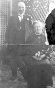 Surrey Hills Historical Society Collection
Photograph, Mr and Mrs William Tacey
William (1857 - 1920) was a butcher. William was born 7 Nov 1857 on the Buckland (River) near Bright, son of John Joseph Tacey and wife Elizabeth Cooper. This was just a few months after the Buckland River anti-Chinese riots. He had siblings Thomas (1856-1929), Mary Ann (1860-1920), Edward (1863-1952) and Arthur Edward (1870-1896). William died 30 March 1920, Camberwell. He married Florence Margaret Edwards in 1884. Both are buried in Box Hill Cemetery (CE-0162). They had 7 surviving children; 2 died in infancy. William was a butcher in Thornbury but moved to Camberwell with his brothers seeing the opportunity in the new suburbs. They set up shops in Canterbury Road, opposite Highfield Road, Surrey Hills; Burwood; corner of Elgar & Whitehorse Roads, opposite the Whitehorse Hotel and Canterbury Road, Surrey Hills just east of Surrey Hotel. The first directory entries are in 1888 & 1889 for the Surrey Hills shop & Elgar Road. In Surrey Hills a substantial property was developed on land which "was purchased by Edward Tacey on 16 September 1889. Edward Tacey was a butcher and the Sands & MacDougall street directory indicates that a butcher’s shop had been constructed on the site and was operating by 1890. It seems that the family lived for some time at a house located next door to the shop at 627 Canterbury Road (visible on the 1909 MMBW plan, but since demolished). On 15 June 1920 Edward Tacey transferred all three blocks of land to Joseph Tacey, most likely his son * and also a butcher, who carried on business from the same premises. Joseph Tacey died on 20 February 1933, after which administration of his estate (which included the three blocks of land) passed to his widow, Mary Dorothy Tacey." (Context P/L Heritage Assessment) Correction: *Edward Tacey (1863 - 1952) was the brother of William Tacey (1857 - 1920). The property passed to Joseph Charles Tacey (1887 - 1933), his nephew and son of William, not his son. His wife was Mary Dorothy Coates. Albert Arthur Tacey was a brother of Joseph Charles Tacey. Edward later moved from the area and continued in the business in a number of regional Victorian centres. In Surrey Hills the business was continued by other members of the family including Albert Arthur Tacey (1902-1959) who lived at 7 Sunbury Crescent, and daughter Stella Florence Tacey and her husband Roy Morris and their son Harry Tacey Morris. The donor of the Tacey collection of photos was Elaine Merle Tacey (1925-2003), daughter of Albert Arthur Tacey. She married Donald McKenzie. A black and white photograph of a couple in the garden. The man is standing and wearing a 3 piece suit whilst the lady is seated and holding a posy of flowers in her lap.(mr) william tacey, butchers, (mr) edward tacey, (mr) thomas tacey, (mr) joseph tacey, (mrs) stella morris, (mr) roy morris, (miss) florence margaret edwards, (mrs) florence margaret tacey, (mr) albert arthur tacey, (miss) stella tacey, (mr) harry tacey morris -
 Federation University Art Collection
Work on paper - Printmaking - Silkscreen, Lin Onus, 'Walawala Garrkman' by Lin Onus, 2001
Lin ONUS (1948-1996) Language: Wiradjuri / Yorta Yorta Lin Onus played a pivotal role in the recognition of Aboriginal art as an expression of a contemporary and dynamic living culture. Prior to his premature death at just 47 years of age he was a prominent, strident, yet non-confrontational agent in renegotiating the history of colonial and Aboriginal Australia. His father, Bill Onus, was the founder of the Aboriginal Advancement League in Victoria and a prominent maker of artefacts in Melbourne. As a young Koori growing up, Lin lived in a cultural environment that included exposure to visiting Aboriginal artists, including Albert Namatjira. He began his artistic life assisting his father in decorating artifacts, went on to develop skills working with metal and painting with air brush as a panel beater; and by 1974 he was painting watercolors and photo-realist landscapes. In the 1970's he completed a set of paintings on the first Aboriginal guerrilla fighter Mosquito, which holds pride of place on the walls of the Advancement League in Melbourne, to this day. Lin Onus was a largely self-taught artist. Particularly important in his development was his visits to Garmedi (Arnhem Land) starting in 1986. Jack Wunuwun, the Yolngu artist, introduced him into the Murrungun-Djinang clan and gave him permission to use some of traditional images in his paintings. His cultural education on the Aboriginal side was also provided by visits to Cummeragunja with his father, and stories told by his uncle Aaron Briggs, known as 'the old man of the forest' who gave him his Koori name - Burrinja, meaning 'star'. They would sit on the banks of the Murray River within view of the Barmah Forest, Lin's spiritual home, the subject of many of his later paintings and his final resting place. Lin's father had been of the Yorta Yorta people from the Barmah Forest country, and Lin also used images from this area in his paintings. The images in his works include haunting photorealist portrayals of the Barmah red gum forests of his father's ancestral country, and the use of rarrk cross-hatching-based based painting style that he learned (and was given permission to use when in Arnhemland). His painting Barmah Forest won Canberra's national Aboriginal Heritage Award in 1994. (http://www.cooeeart.com.au/aboriginal_artist/lin_onus/A, accessed 18 May 2015) This item is part of the Federation University Art Collection. The Art Collection features over 1000 works and was listed as a 'Ballarat Treasure' in 2007.Framed limited edition silkscreen.Signed 'Onus' lower right (posthumously by Tiriki Onus) Edition 68/80art, artwork, lin onus, onus, printmaking, screenprint, aboriginal, dreaming, frogs, available -
 Eltham District Historical Society Inc
Photograph - Digital Photograph, Alan King, Panton Hill Primary School, 27 March 2008
The Panton Hill Primary School building, which has served the community since 1889, was not the area's first. Kingston School (an early name for Panton Hill) opened in May 1865. This was replaced in 1871 when the Panton Hill School number 1134 opened and in 1874 the school moved to its current location [September 2023] where many additions and renovations have taken place to meet the needs of local children in the 21st century. Covered under Heritage Overlay, Nillumbik Planning Scheme. Published: Nillumbik Now and Then / Marguerite Marshall 2008; photographs Alan King with Marguerite Marshall.; p63 The Panton Hill Primary School building, which has served the community since 1889, was not the area’s first. In 1871 Henry Edelman opened a Common School in a paling-clad hut, replacing the Kingstown No 786 school. The two-acre (0.8ha) site of crown land had previously been held under Miners Right. In 1875 the Education Department bought a building on the main road for State School No 1134, for £200 and remodelled it as a school.4 Panton Hill had as one of its teachers, Frank Tate, who was to become one of Victoria’s most influential educational reformers. It was his first school, when he began teaching on January 22, 1884, as a 20 year old.5 The following month Robert J Harris was appointed to the school and remained as head teacher until his death in 1887. His son R C Harris was apprenticed to Mr Rossiter, editor of the first local paper. The Evelyn Observer, first published in 1873. Harris later bought the newspaper which remained a family business until the 1920s. J Hughes of Cherry Tree Road succeeded Harris as teacher at Panton Hill and sold his land for the school site. Though now unrecognisable, the school building includes the classroom of the last Smiths Gully State School No 1737, which was built in 1882, and moved to Panton Hill in 1894. From 1922 each school day began with the ringing of the bell, which is still in its stand, and is an unusually old memorial of this kind. To accommodate the growing population, the building was remodelled, with additions in 1923 and classrooms were added in 1955, 1963 and 1970. The former teacher’s residence is the only surviving 19th century dwelling in the centre of Panton Hill, and is now used as part of the school. The residence was originally rectangular but is now L-shaped. Similar weatherboard State School buildings in the shire from this period are the Kangaroo Ground and the St Andrews Primary Schools. All were standard Education Department/Public Works Department designs.This collection of almost 130 photos about places and people within the Shire of Nillumbik, an urban and rural municipality in Melbourne's north, contributes to an understanding of the history of the Shire. Published in 2008 immediately prior to the Black Saturday bushfires of February 7, 2009, it documents sites that were impacted, and in some cases destroyed by the fires. It includes photographs taken especially for the publication, creating a unique time capsule representing the Shire in the early 21st century. It remains the most recent comprehenesive publication devoted to the Shire's history connecting local residents to the past. nillumbik now and then (marshall-king) collection, panton hill primary school -
 Flagstaff Hill Maritime Museum and Village
Postcard - Historical, Flagstaff Hill, Christ Church, Warrnambool, Early 20th century
The nine postcards in this set were donated together and date to the early 1900s. All but one postcard in this set shows images of Warrnambool, in the Western District of Victoria; the other has a London image. The postcards were all printed in Great Britain according to that country’s postal regulations. The fronts of all cards have titles printed in red. Most of the images on the cards are attributed to photographer Joseph Jordan and belong to the Jordan Series. The back of these cards has an outline for a postage stamp, a vertical dividing line and a heading on each side of the line to separate the Correspondence from the Address. Postcards or ‘correspondence cards’ appeared in Britain in 1894. They were plain cards with a space for the message on one side and an address on the other; regulations didn’t allow anything but the address to be written on the ‘address’ side. In 1902 the British regulations then allowed a picture to be printed on the front and the address on the back, so messages had to be written on the picture side. Soon, the regulations changed and the back was divided for a message and the address. Christ Church Warrnambool – The image on this card shows Christ Church, a stone building built in 1856. The Anglican church is in Henna Street, Warrnambool. The church, outer buildings and grounds are heritage-listed. Its bell tower harbours German bells. Joseph Jordan - Joseph Jordan was born in 1841 in Leicester England. When he was 16 he joined the 7th Queen's Own Hussars and was sent to India at the outbreak of the mutiny. He took part in the relief of Lucknow and remained in India for eleven years. It was during this time, he became interested in photography. He was posted to New Zealand and later came to Victoria, becoming a sergeant major of the Mounted Rifles. In the mid-1880s he came to the Western district where he was responsible for establishing units of the Mounted Rifles in various country towns such as Dunkeld, Mortlake, Panmure, Bushfield, Koroit etc. He resigned from the army in 1889 and set up a professional photography studio in Liebig Street, Warrnambool. He became very well known in the Western District for family photographs, official photographs of local councillors and groups as well as views of local scenery. In 1891 he photographed the wrecked barque ‘Fiji’ at ‘Wrecks Beach’ near Princetown. His business was taken over by his son Arthur around 1917. Joseph was a keen rifle shot and in 1924 he donated the "Jordan Shield" as a prize to the Victorian Rifle Association. He was made a "Life Honorary Member" of the Warrnambool Returned Soldiers League and in 1933 he was recognised as being the oldest living soldier in Victoria. Joseph died in 1935 aged 95.This card is the only one of the nine cards with the location of Warrnambool added to the name 'Joseph Series'. It is also the only one that has text within the outline for the postage stamp. The font used for the test of the headings is slightly different to the other cards. Joseph Jordan is a significant figure in Warrnambool history as he helped to establish early units of the Mounted Rifles (G Company) in local towns during the late 1880's and later, photographed local scenes, groups and citizens of early Warrnambool. This postcard of Christ Church Warrnambool is significant for its connection to the church. The early building of the church in 1856, within the first decade of Warrnambool being proclaimed a town, shows the strong religious desire of the community. The church is part of Warrnambool's life events and the historical significance of the building,Postcard, one of nine, landscape orientation, coloured print within an oval border and mauve-toned shading. The cameo image is of the Interior of the church chapel, with exposed timber beams, white arches decorated with flowers, pews with books on shelves, and organ pipes. There is text on the image. The title is in red print on the front of the card. The back has inscriptions and outlines for a postage stamp. There is no correspondence written on the card. Jordan Series, printed in Great Britain.Front, in red: “CHRIST CHURCH, WARRNAMBOOL” Back in black: “Jordan Series” “POST CARD” “PRINTED IN GREAT BRITAIN” “For correspondence” “The Address only to be written here” Text on the arch: "THE LORD OF HOSTS"flagstaff hill maritime museum, flagstaff hill maritime village, flagstaff hill maritime museum and village, maritime museum, warrnambool, great ocean road, warrnambool and district, warrnambool scenes, local scenes, views of warrnambool, joseph jordan, jordan series, jordan photography, postcard, souvenir, correspondence, cameo postcard, landscape, christ church, bell tower, german bells, warrnambool church, religious building, stone building, anglican church, parish of warrnambool, arch pillars -
 Flagstaff Hill Maritime Museum and Village
Postcard - Historical, Warrnambool, Christ Church, Warrnambool, Early 20th century
The nine postcards in this set were donated together and date to the early 1900s. All but one postcard in this set shows images of Warrnambool, in the Western District of Victoria; the other has a London image. The postcards were all printed in Great Britain according to that country’s postal regulations. The fronts of all cards have titles printed in red. Most of the images on the cards are attributed to photographer Joseph Jordan and belong to the Jordan Series. The back of these cards has an outline for a postage stamp, a vertical dividing line and a heading on each side of the line to separate the Correspondence from the Address. Postcards or ‘correspondence cards’ appeared in Britain in 1894. They were plain cards with a space for the message on one side and an address on the other; regulations didn’t allow anything but the address to be written on the ‘address’ side. In 1902 the British regulations then allowed a picture to be printed on the front and the address on the back, so messages had to be written on the picture side. Soon, the regulations changed and the back was divided for a message and the address. Christ Church Warrnambool – The image on this card shows Christ Church, a stone building built in 1856. The Anglican church is in Henna Street, Warrnambool. The church, outer buildings and grounds are heritage-listed. Its bell tower harbours German bells. Joseph Jordan - Joseph Jordan was born in 1841 in Leicester England. When he was 16 he joined the 7th Queen's Own Hussars and was sent to India at the outbreak of the mutiny. He took part in the relief of Lucknow and remained in India for eleven years. It was during this time, he became interested in photography. He was posted to New Zealand and later came to Victoria, becoming a sergeant major of the Mounted Rifles. In the mid-1880s he came to the Western district where he was responsible for establishing units of the Mounted Rifles in various country towns such as Dunkeld, Mortlake, Panmure, Bushfield, Koroit etc. He resigned from the army in 1889 and set up a professional photography studio in Liebig Street, Warrnambool. He became very well known in the Western District for family photographs, official photographs of local councillors and groups as well as views of local scenery. In 1891 he photographed the wrecked barque ‘Fiji’ at ‘Wrecks Beach’ near Princetown. His business was taken over by his son Arthur around 1917. Joseph was a keen rifle shot and in 1924 he donated the "Jordan Shield" as a prize to the Victorian Rifle Association. He was made a "Life Honorary Member" of the Warrnambool Returned Soldiers League and in 1933 he was recognised as being the oldest living soldier in Victoria. Joseph died in 1935 aged 95.This card is the only one of the nine cards with the location of Warrnambool added to the name 'Joseph Series'. It is also the only one that has text within the outline for the postage stamp. The font used for the test of the headings is slightly different to the other cards. Joseph Jordan is a significant figure in Warrnambool history as he helped to establish early units of the Mounted Rifles (G Company) in local towns during the late 1880's and later, photographed local scenes, groups and citizens of early Warrnambool. This postcard of Christ Church Warrnambool is significant for its connection to the church. The early building of the church in 1856, within the first decade of Warrnambool being proclaimed a town, shows the strong religious desire of the community. The church is part of Warrnambool's life events and the historical significance of the building,Postcard, one of nine, landscape orientation, coloured print within an oval border and mauve-toned shading. The cameo image is a stone castle-top bell tower beside a church building flanked by trees. A stone fence is across the front, with pedestrian and vehicle white picket gates. The title is in red print on the front of the card. There is no correspondence written on the card. The reverse has inscriptions and outlines for a postage stamp. Jordan Series, printed in Great Britain.Front, in red: “CHRIST CHURCH, WARRNAMBOOL” Back in black: “Jordan Series” “POST CARD” “PRINTED IN GREAT BRITAIN” “For correspondence” “The Address only to be written here”flagstaff hill maritime museum, flagstaff hill maritime village, flagstaff hill maritime museum and village, maritime museum, warrnambool, great ocean road, warrnambool and district, warrnambool scenes, local scenes, views of warrnambool, joseph jordan, jordan series, jordan photography, postcard, souvenir, correspondence, cameo postcard, landscape, christ church, bell tower, german bells, warrnambool church, religious building, stone building, anglican church, parish of warrnambool -
 Flagstaff Hill Maritime Museum and Village
Photograph - Print of S. S. Rowitta, A.V. Gregory, 1912
S. S. ROWITTA: - The 1909 steam ferry, S. S. Rowitta, was installed as an exhibit at Flagstaff Hill in 1975 and was enjoyed by many visitors for 40 years. S. S. Rowitta was a timber steam ferry built in Hobart in 1909 using planks of Huon and Karri wood. She was a favourite of sightseeing passengers along Tasmania’s Tamar and Derwent rivers for 30 years. The Rowitta was also known as Tarkarri and Sorrento and had worked as a coastal trading vessel between Devonport and Melbourne, and Melbourne Queenscliff and Sorrento. In 1974 the S. S. Rowitta was purchased by Flagstaff Hill to convert into a representation of the Speculant, a historic and locally significant sailing ship listed on the Victorian Heritage Database. (The Speculant was built in Scotland in 1895 and traded timber between the United Kingdom and Russia. Warrnambool’s P J McGennan & Co. then bought the vessel to trade pine timber from New Zealand to Victorian ports and cargo to Melbourne. She was the largest ship registered with Warrnambool as her home port, playing a key role in the early 1900s in the Port of Warrnambool. In 1911, on her way to Melbourne, she was wrecked near Cape Otway. None of the nine crew lost their lives.) The promised funds for converting the S. S. Rowitta into the Speculant were no longer available, so she was restored back to her original configuration. She represented the importance of coastal traders to transport, trade and communication in Australia times before rail and motor vehicles. Sadly, in 2015 the time had come to demolish the Rowitta due to her excessive deterioration and the high cost of on-going repairs. She had given over 100 years of service and pleasure to those who knew her. Arthur Victor Gregory (known as A. V. Gregory) was born in Melbourne in 1867. He was the son of George Frederick Gregory who was an established marine painter with a studio in South Melbourne. A. V. Gregory worked with his father and his elder half-brother (George Frederick Junior). They made numerous photographic reproductions of their ships' portraits, selling the originals to captains and owners and the photographic prints to the crews. A. V. Gregory inherited the business on the death of his father in 1890 and continued to paint until World War 2 when he stopped for wartime security reasons. Gregory worked mainly in watercolour and gouache. He kept all his working sketches so he could repeat earlier paintings and make more copies of the same ship. His carefully detailed portraits of every kind of vessels seen on Port Phillip Bay created a body of work regarded as a valuable record of the maritime traffic of that period.This print is a significant example of the work of the well-known and well-respected marine painter A. V. Gregory who created a detailed record of shipping in the Port Phillip Bay area in the years before W.W. 2. It is also significant as it connects the history of the S. S. Rowitta, which was a large exhibit on display at Flagstaff Hill Maritime Village from the museum’s early beginnings until the vessel’s end of life 40 years later. The S. S. Rowitta represents the importance of coastal traders to transport, trade and communication along the coast of Victoria, between states, and in Australia before rail and motor vehicles and is significant for its association with Tasmanian history from the early to mid-1900s. The vessel was an example of a ferry built in the early 20th century that served many different roles over its lifetime of over 100 years.This is a photograph of a watercolour painting of the S. S. Rowitta. It shows a steamer moving through the water. The ship has a blue, metal hull, a wooden lower and upper deck, a lifeboat and smoke coming out of a chimney. Flags are flying from the bow, the stern and the mast. Seven figures can be seen on the decks. A second boat can be seen in the distance in the far left of the picture. It has the signature "A. V. Gregory - 12" in the bottom left corner and the title "S. S. Rowitta - 121 tns" in the lower right corner.Signed "A. V. Gregory -12-" Titled "The S. S. Rowitta / -121 tns" Printed on the ships' bow - "ROWITTA"flagstaff hill maritime museum and village, warrnambool, great ocean road, shipwreck coast, s. s. rowitta, rowitta, a. v. gregory, painting, marine painting, marine painter, steamer, steam ferry, passenger ferry, alfred gregory, tarkarri, sorrento, speculant, print, photograph