Showing 30645 items
matching hill
-
 Rutherglen Historical Society
Image, 1914 (Exact)
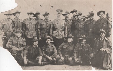
The photo could be of some of the following: Percy Fullerton, B. Bevan. A. McPherson, A. Carter, C Eggleston, G. Libound, A. Hill, W Monan, J. Waugh, J. Slowe, J.Pearce,B. Canning, G. Ball, H. Evans. The man in the centre of the photo in the cap is Lieutenant Charles Denehy/later Colonel Denehy, the man extreme right front row is Joseph Nott.Black and white postcard photograph of group of men in uniform, 11 standing, 6 seated or kneeling in front.Written on back of photo: "Rutherglen Boys of the 7th Battalion. Sailed with the first Australian Contingent" On separate note: "Rutherglen Boys of the 7th Battalion sailed with the first Aust. Contingent. Henry Andrew (Harry) Clarkson 3rd from right, standing, back row. Back row: 5th from left - Major Gerry Chambers. Front row: 6th from left - Joseph Nott."percy fullerton, bevan, mcpherson, carter, eggleston, libound, hill, monan, waugh, slowe, pearce, cannign, ball evans, charles denehy, joseph nott, harry clarkson, gerry chambers, 7th battalion, world war 1, world war i, ww1, martin balsarini, 4th lighthorse -
 Surrey Hills Historical Society Collection
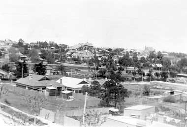
Photograph, Surrey Hills looking south-east from the steeple of Holy Trinity Church, 1921, 1921
The property in the foreground is 'Edgeware' at 171 Union Road, a house built by the Zeplin family. It became the home / residence of Dr Percy Liddle and later Dr James Landells Blakie. By the time this photo was taken Dr Blakie had moved across the road to 174 Union Road. In the background behind the 2 houses in the foreground is the Surrey Hills Stationmaster's house, sitting behind a picket fence. The Alan Holt register gives a build date of c1915 for this house, which fits stylistically. The first stationmaster was probably Michael Ginnane, who stayed in the area after he retired, moving to 1 Russell Street. This property was listed as 8 Bedford Avenue, the only house on the south side of the road. It was demolished in c1972 to make way for widening of the rail track with a third line. The photographer Norman Carter took many photos of Surrey Hills and Mont Albert from the 1920s, in particular of events and activities associated with the Church of England.Black and white photo taken from the steeple of Holy Trinity Church looking across housing towards the railway line and Albany / Windsor Crescents and on towards Canterbury Road. Surrey Hills Primary School and St Stephens Presbyterian Church feature prominently on the horizon. The stationmaster's cottage is centre left adjacent to a large conifer-like tree, with a white fence delineating the railway yards.On back of original: "6-11-21" and in a different hand in biro: "from tower of Holy Trinity Church"albany crescent, windsor crescent, st stephens presbyterian church, surrey hills primary school, railways, stationmasters' houses, bedford avenue, norman carter, edgeware, dr percy liddle, dr james blakie -
 Bendigo Military Museum
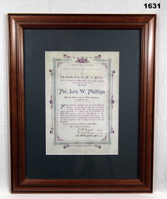
Certificate - CERTIFICATE WW1, FRAMED, c.1918
WILLIAM LESLIE PHILLIPS No 5751 enlisted in the AIF in 18th reinforcements 6th Batt on 13.3.1916 age 20 years 11 months. Embarked for England 3.7.1916, embarked for France 29.9.1916, hospitalised 30.11.1916 with Trench Feet., Transferred to 60th Batt 19.9.1917, hospitalised 3.12.1917 with Trench Feet, return to unit 10.12.1917, KIA France 5.4.1918.Olive green mount, rectangular wooden frame. Rectangular coloured certificate in purple & green honouring Pte LES W PHILLIPS. “From the residents of White Hills to the family of Pte LES W PHILLIPS, KIA at Villers-Bretonneux April 5th 1918”documents-certificates, frame accessories, military history, white hills -
 Greensborough Historical Society
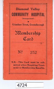
Membership card, Diamond Valley Community Hospital, Diamond Valley Community Hospital Membership Card, 16/06/1942
Membership card for Diamond Valley Community Hospital. Members could obtain reduced in-patient fees on presentation of this card.Textured card, salmon on front, white on inside, folded once, with receipt pasted in. With covering letter to Noel Withers from the donor, Bob Manuell"F. Squire, Gladstone Rd Briar Hill, 17/6/42, Life 30 pounds. [Issued by] P Stubley"diamond valley community hospital -
 Orbost & District Historical Society
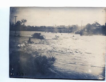
black and white photograph, January 1934
From The Argus (Melbourne) on January 10 1934 "Damage estimated at £500,000 has been caused by the floods in the Orbost district. No loss of life occurred, largely owing to the heroic efforts of rescue parties. Many families spent Monday night on the roofs of houses or in trees, surrounded by deep, rushing flood waters." This 1934 flood was devastating, destroying a section of the 1922 Orbost bridge - the centre span was washed away -. wrecking fences, bridges and roads, dumping silt and debris on the rich river flats and drowning cattle. This is a pictorial record of the 1934 flood, a significant event in the history of Orbost.A black / white photograph of floodwaters. In the middle of the water can be see debris including a large spoked wheel. In the background are houses and fences.on back - "near Hilyer's garage at foot of hill Main Street Caravan Park on right" on front at bottom left - "1934"orbost-flood-1934 flood-orbost -
 Anglesea and District Historical Society
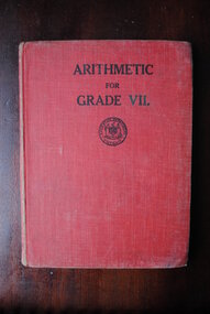
Education Department, W.M. Houston, Government Printer Melbourne, Arithmetic for Grade VII, 1941
Education Department (First Edition) 1941. Fabric covered cardboardFaye Harris, 61 Lucknow Street, Mitcham. WU 2906. Box Hill Girls Technical School. Form 1F.education department, arithmetic, book -
 Dandenong/Cranbourne RSL Sub Branch
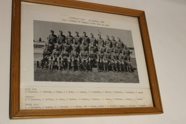
Photograph - Framed photo, Wangaratta Camp 23rd October 1940, Unknown
WWII historical significancePlatoon photo of 30 men with their names on the photo1 Platoon 'C' Company, 2/14 Infantry Training Battalion. Writing on the back - to Cliff Hill with my compliments -
 Surrey Hills Historical Society Collection
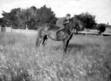
Photograph, Stan Smith c1916, 1916
Stan Smith, then of 3 Vincent Street, on his father’s horse in Mont Albert Road in about 1916. Mr Charles Smith was an insurance officer whose area was from Burke to Elgar Road; he used his phaeton for transport. Oral testimony - Stan Smith: “We had a stable for the horse near the house and a yard but we tethered the horse at the end of a long rope on paddocks in Empress Road- the area from Mont Albert Road to Guildford Road. We used to put in an iron peg. Some horses were tethered similarly in various paddocks but not a lot of people had horses by this time. A few cows grazed around them.” The picket fence on the left and the trees were those of ‘Monserrat’ – the Parer home, now entered from 26a Wandsworth Road as the Mont Albert Road frontage was sold off many years ago. A black and white photograph of a young boy on a horse. There are a number of well established trees in the background and a fence. The young boy is identified on the back of the small photograph as "Stan" on "Bob" the horse.On back of small photograph: "Stan on Bob / Mont Albert Rd / Surrey Hills 1916 / In front of / Mr Parers home"(mr) stan smith, vincent street, surrey hills, empress road, wandsworth road, house names, parer home, (mr) charles smith, 'monserrat' -
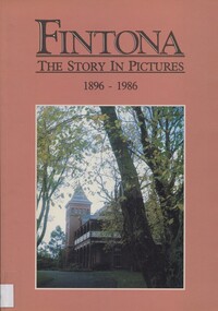 Surrey Hills Historical Society Collection
Book, Fintona - the story in pictures, 1896-1986, 1986
Compiled by Phyllis Reichl (b1915). She was awarded an Honorary Life Membership of the Geography Teachers' Association of Victoria. She died in 2005.Soft cover book of 110 pages with annotated photos. There is a 4 page overview of the school's history and an appendix with identification of individuals in group photos.Inside the front cover: "For the Surrey Hills Historical Society / from Fintona Girls' School / 19.10.98 Alison Adams, Archivist"schools, education, fintona, independent schools, (ms) alison adams, (ms) phyllis reichl -
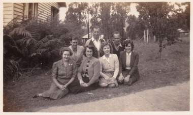 Marysville & District Historical Society
Photograph (item) - Black and white photograph, Approximately 1944
A black and white photograph of an unknown group of people sitting on the lawn at Roseleigh guest house in Marysville. The photograph was taken in about 1944.A black and white photograph of an unknown group of people sitting on the lawn at Roseleigh guest house in Marysville. The photograph was taken in about 1944.Marysville - Roseleigh/ about 1944 Front 3rd Right/ Nancy Duncan ALPHA/ PHOTO SERVICE/ BOX HILL 93marysville, victoria, australia, roseleigh guest house, grieve family, thomas charles grieve, john arthur grieve, rose grieve, ackerman family, mary moyne, elise ackerman, ken mcleod, george peters, rose emily pullum, beltana, rose lillian smith, ivy may grieve, alexander james ficinus, raymond charles smith, accommodation, photograph, nancy duncan -
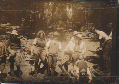 University of Melbourne, Burnley Campus Archives
Photograph - Sepia print, Students and Staff Working in the Gardens, 1938-1944
Sepia photograph. Group of students and staff working in the Gardens.Burnley 1938? "Janice Waemaker?, June Bishop, Trevaskis." E. Hill has added "1944? See graduation lists."janice waemaker, june bishop, students, staff, students working outside -
 Whitehorse Historical Society Inc.
Article, City council a victim of circumstances|Bureaucracy bogs down conference|Talks soon on council plan, 1972
Photocopy of three articles concerning Nunawading Council:Photocopy of three articles concerning Nunawading Council:|An unreported move by the Local Government Department has led to appeals against flats in McGhee Avenue not being delivered to the Department.|The Municipal Association of Victoria has said it cannot discuss Nunawading's motion for a tripartite conference between federal, state and local government.|Discussions will be held on a regional council including Box Hill, Camberwell, Knox, Waverley and Nunawading councils.Photocopy of three articles concerning Nunawading Council:city of nunawading, victoria. local government department, municipal association of victoria, city of box hill, city of camberwell, city of ringwood, city of knox, city of waverley, mcghee avenue, mitcham -
 Kew Historical Society Inc
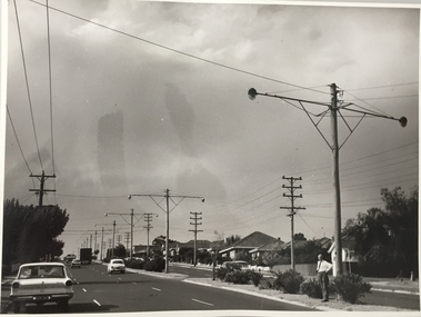
Photograph, Stuart Tompkins Studio, Electricity Supply Poles, Warrigal Road, Holmesglen, 1965
Research provided by Stuart Tompkins Studio, Box Hill, into alternatives for median strip street lighting to be used in Burke Road, Kew. The photographers identified variants in different suburbs appropriate to Kew's needs. The series from which the photograph is drawn provides a snapshot by a commercial photographic studio of each named vicinity in 1965 as well as providing examples of public works infrastructure being commissioned by local government in the 1960s. The photos originally formed part of the Engineering Department's files in the City of Kew before being donated to the kew Historical Society.Electricity Supply Poles, Warrigal Road, Holmesglen, 1965. Stuart Tompkins Studio provided this photograph for the Kew City Council. The photograph of Warrigal Road, north of Holmesglen looking north depicts wooden poles with bracket light fittings. These were the same as those proposed for Kew, except the lights and fittings were not to be 350 watt. Mercury lamps were preferred. [There are three copies of this photograph in the Collection.] Typed inscription on reverse: "Electricity Supply Poles. Photographed for Kew City Council 8/2/65. No.3 Warrigal Road - North of Holmesglen looking north. Wooden poles with bracket fittings same as those proposed for Kew except lights and fittings are not for 250 watt c. c. mercury lamps proposed. Wooden pole 3' up 11 3/4" dia." Studio stamp: "Stuart Tompkins Studio. 547 Station Street, Box Hill. WX1439."stuart tompkins studio, warrigal road (holmesglen) 1965, street lighting -
 Kew Historical Society Inc
Photograph, Stuart Tompkins Studio, Electricity Supply Poles, Warrigal Road, Holmesglen, 1965
Research provided by Stuart Tompkins Studio, Box Hill, into alternatives for median strip street lighting to be used in Burke Road, Kew. The photographers identified variants in different suburbs appropriate to Kew's needs. The series from which the photograph is drawn provides a snapshot by a commercial photographic studio of each named vicinity in 1965 as well as providing examples of public works infrastructure being commissioned by local government in the 1960s. The photos originally formed part of the Engineering Department's files in the City of Kew before being donated to the kew Historical Society.Electricity Supply Poles, Warrigal Road, Holmesglen, 1965. Stuart Tompkins Studio provided this photograph for the Kew City Council. The photograph of Warrigal Road, north of Holmesglen looking north depicts wooden poles with bracket light fittings. These were the same as those proposed for Kew, except the lights and fittings were not to be 350 watt. Mercury lamps were preferred. [There are three copies of this photograph in the Collection.] Typed inscription on reverse: "Electricity Supply Poles. Photographed for Kew City Council 8/2/65. No.3 Warrigal Road - North of Holmesglen looking north. Wooden poles with bracket fittings same as those proposed for Kew except lights and fittings are not for 250 watt c. c. mercury lamps proposed. Wooden pole 3' up 11 3/4" dia." Studio stamp: "Stuart Tompkins Studio. 547 Station Street, Box Hill. WX1439."stuart tompkins studio, warrigal road (holmesglen) 1965, street lighting -
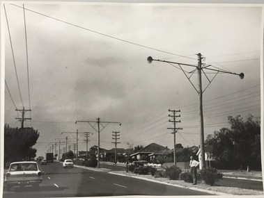
 Kew Historical Society Inc
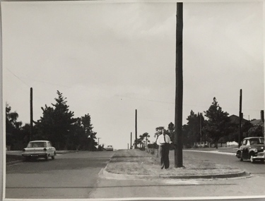
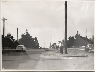
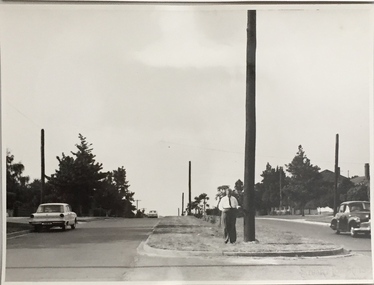
Photograph, Stuart Tompkins Studio, Electricity Supply Poles, Burke Road, Kew, 1965
Research provided by Stuart Tompkins Studio, Box Hill, into alternatives for median strip street lighting to be used in Burke Road, Kew. The photographers identified variants in different suburbs appropriate to Kew's needs.The series from which the photograph is drawn provides a snapshot by a commercial photographic studio of each named vicinity in 1965 as well as providing examples of public works infrastructure being commissioned by local government in the 1960s. The photos originally formed part of the Engineering Department's files in the City of Kew before being donated to the kew Historical Society.Electricity Supply Poles, Burke Road, Kew, 1965. This photograph of Burke Road, Kew was taken just north of Kilby and Doncaster Roads looking north. Stuart Tompkins Studio provided the photograph for the Kew City Council. In the photograph are a number of electricity supply poles that have been erected in the median strip, in addition to some new poles on each footpath. The nearest wooden pole is stated to be 13.5″ in diameter. The electricity poles in Burke Road required Kew Council to investigate comparable designs in other Melbourne municipalities. [There are three copies of this photograph in the Collection.] Typed inscription on reverse: "Electricity Supply Poles. Photographed for Kew City Council 8/2/65. No.5 Burke Road - Kew, just north of Kilby and Doncaster Roads looking north. Some of seven poles already erected in median strip. Shows also some new poles erected on each footpath. Nearest wooden pole 13 1/2" dia." Studio stamp: "Stuart Tompkins Studio. 547 Station Street, Box Hill. WX1439."stuart tompkins studio, street lighting, south road (moorabin) 1965 -
 Kew Historical Society Inc
Photograph, Stuart Tompkins Studio, Electricity Supply Poles, Burke Road, Kew, 1965
Research provided by Stuart Tompkins Studio, Box Hill, into alternatives for median strip street lighting to be used in Burke Road, Kew. The photographers identified variants in different suburbs appropriate to Kew's needs.The series from which the photograph is drawn provides a snapshot by a commercial photographic studio of each named vicinity in 1965 as well as providing examples of public works infrastructure being commissioned by local government in the 1960s. The photos originally formed part of the Engineering Department's files in the City of Kew before being donated to the kew Historical Society.Electricity Supply Poles, Burke Road, Kew, 1965. This photograph of Burke Road, Kew was taken just north of Kilby and Doncaster Roads looking north. Stuart Tompkins Studio provided the photograph for the Kew City Council. In the photograph are a number of electricity supply poles that have been erected in the median strip, in addition to some new poles on each footpath. The nearest wooden pole is stated to be 13.5″ in diameter. The electricity poles in Burke Road required Kew Council to investigate comparable designs in other Melbourne municipalities. [There are three copies of this photograph in the Collection.] Typed inscription on reverse: "Electricity Supply Poles. Photographed for Kew City Council 8/2/65. No.5 Burke Road - Kew, just north of Kilby and Doncaster Roads looking north. Some of seven poles already erected in median strip. Shows also some new poles erected on each footpath. Nearest wooden pole 13 1/2" dia." Studio stamp: "Stuart Tompkins Studio. 547 Station Street, Box Hill. WX1439."stuart tompkins studio, street lighting, south road (moorabin) 1965 -
 Bendigo Historical Society Inc.
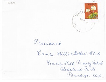
Document - BEREAVEMENT NOTE OF THANKS
Document. A printed bereavement note of thanks on the passing of Stephen James Bourke, 21 Sept. 1976, aged 66 years. Contained inside an envelope addressed (handwritten) to The President, Camp Hill Mother's Club, Camp Hill P.S., Rosalind Park, Bendigo, 3550.person, individual, personal, stephen james bourke, bereavement, camp hill mother's club -
 Bendigo Historical Society Inc.
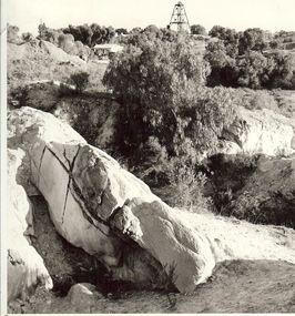
Photograph - MINE WORKINGS, ROCK OUTCROP
Black and white photo: large rock outcrop and mine working on treed hill in foreground. House in middle ground and poppet head on hilltop horizon. Victoria Hill area ? On back Wallace Studios/6 Ruth St.,/ Golden Square/ Phone Go 37565Robert Wallace Studios, Golden Squaremine, gold, mining landscape, bendigo, mines and mining, mines, mine, mining, landscape, victoria hill -
 Bendigo Historical Society Inc.
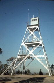
Slide - PETER ELLIS COLLECTION: SLIDE, May 1970 - Jan 1972
Coloured slide transparency. Image is of a tall metal tower on top of a hill. The tower is white and a ladder is visible on the right hand side. There are two aerials and a wooden building on the top platform. The words Lookout Tower and One Tree Hill are handwritten on the top and bottom borders.Kodachrome Transparencyslide, bendigo, bendigo institute of technology -
 Bendigo Historical Society Inc.
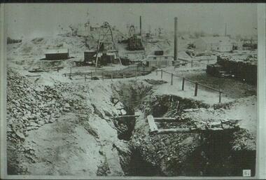
Slide - ALBERT RICHARDSON COLLECTION: VICTORIA HILL
Slide: Looking north to Victoria Hill from New Chum and Victoria Quartz, image taken in early 1870's. poppet heads, wood stacks, chimney stacks, mining excavation in foreground, mullock heaps. Possibly a stamper in background against crest of hill.No.6 on bottom of slidemine, gold, north to victoria hill., bendigo mines-jack hattam collection -
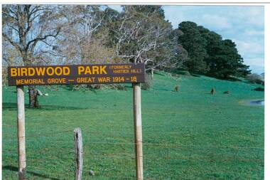 Buninyong & District Historical Society
Photograph - Original Photograph, Mr. C.J. Brooks, View up Mt. Innes from Learmonth St., showing Birdwood Park sign, September 1995
connections to early settlement and WWI.Colour photo, View up Mt. Innes from Learmonth St., showing Birdwood Park sign. Conifers are WWI memorial created as Birdwood Grove. Hill has also been known as Hastie's Hill, Mt. Loch, Birdwood Park and Mt. Innes.buninyong, birdwood grove, hastie's hill, mt. loch, mt. innes -
Canterbury History Group
Ephemera - touchstones to WW1 in Balwyn, Camberwell, Canterbury and Surrey Hills, Susan Barnett, 1/04/2015 12:00:00 AM
Booklet compiled by Susan Barnett, President of the Surrey Hills Historical Society with the assistance of the Balwyn Historical Society, Camberwell Historical Society, Canterbury History Group and the Surrey Hills Historical Society, for a bus tour of significant places in Boroondara to commerate the centenary of the Gallipoli Landing.beckett park memorial, white> dorothy sevilla, cahill> francis matthew, cahill> martin, cahill> richard nicholas, cahill> kevin martin, lone pine dairy - balwyn, bignell> alfred charles, canterbury citizens carnival, canterbury gardens, soldiers - memorial hall - canterbury, canterbury memorial home units, canterbury primary school, camberwell city rsl sub-branch, golding> herbert, daly> gustav anthony disney, daly> william constant beck, daly> clarence wells didier, wattle park lone pine, clock tower memorial> wattle park, hethersett house - plc - burwood, surrey gardens - memorial cross, surrey gardens - the shrine, steele> mrs charles h d, blogg> john kendrick, gawler> john stephens, mawson> frederick w, webster> clarence -
Glenelg Shire Council Cultural Collection
Negative - Negative - Portland Bird Sanctuary, ZILLAH MASCHMEDT, PHOTOGRAPHER, c. 1934
NEGATIVE FOR BLACK AND WHITE PHOTOGRAPH. Portland bird sanctuary. Water and reeds in foreground. Magazine Hill in the backgroundnegative, bird sanctuary, birdlife, waterfowl, wildlife -
Glenelg Shire Council Cultural Collection
Photograph, c. 1970
Photographic print of a rephotographed photograph. Image shows Bartons Beach in foreground, Observatory Hill with lighthouse in backgroud. -
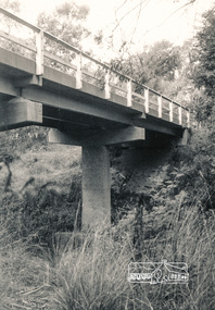 Eltham District Historical Society Inc
Photograph, Watsons Creek Bridge, Christmas Hills, 1970c
Black and white photograph of bridge over Watsons Creek, Christmas Hills (Clintons Road?) c.1970bridges, watsons creek, christmas hills -
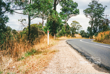 Eltham District Historical Society Inc
Photograph, Kangaroo Ground - St Andrews Road
Five colour photographs of Kangaroo Ground/St Andrews Road, Kangaroo Ground/Panton Hill arearoads, st andrews road, kangaroo ground/st andrews road, panton hill, kangaroo ground -
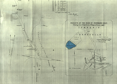 Federation University Historical Collection
Plan, A.M. Howitt, Nuggets at the Head of Ironbark Gully, Tarnagulla, c1907
Plan showing part of the township of Tarnagulla, and the Ironbark Gully area including Western Reef and Creek's Hill.tarnagulla, ironbark gully, western reef, creek's hill, cgt -
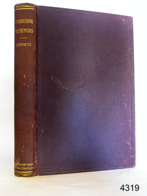 Flagstaff Hill Maritime Museum and Village
Book, Engineering Mathematics
Richard Golding ownerEngineering Mathematics Author: Charles P Steinmetz Publisher: McGraw-Hill Book Company Date: 1911 flagstaff hill, warrnambool, shipwrecked-coast, flagstaff-hill, flagstaff-hill-maritime-museum, maritime-museum, shipwreck-coast, flagstaff-hill-maritime-village, book, engineering mathematics -
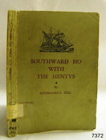 Flagstaff Hill Maritime Museum and Village
Book, Southward Ho With The Hentys
Southward Ho With The Hentys Author: Fitzmaurice Hill Publisher: Whitcombe & Tombs Pty Ltd Date: 1947Label on spine with typed text R.A. 994.5 HIL Front endpaper has a sticker from Warrnambool Children’s Library warrnambool, shipwrecked-coast, flagstaff-hill, flagstaff-hill-maritime-museum, maritime-museum, shipwreck-coast, flagstaff-hill-maritime-village, shipwrecked-artefact, book, fitzmaurice hill, southward ho with the hentys, henty