Showing 55760 items
matching documents-maps
-
 Ringwood and District Historical Society
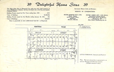
Flyer, Subdivision advertisement for sale of home sites - Ringwood, Victoria - 1956
Cardboard-backed advertisement for 39 home sites for sale, with location map, and summary of local real estate statistics in 1955 & 1956. Handwritten date noted in top right corner - 24th March, 1956.Subdivision map includes Reilly Street, Philip Street, Lorienne Street and Daisy Street in Heathmont. Surveyors: Messrs Little and Brosnan. Agents in conjunction: Peter Martin Pty. Ltd., Estate Agents, 55-57 Latrobe Street, Melbourne (Phone) FB 3571, FB 2783, and Peter Aubin Pty. Ltd., Auctioneers & Estage Agents, 345 Lonsdale Street, Dandenong (Phone) Dandenong 340, after hours Dandenong 932, 70. -
 Bendigo Military Museum
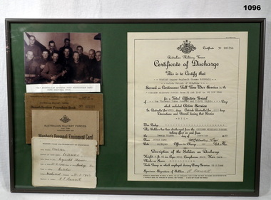
Memorabilia - COLLAGE, FRAMED, c.1942 - 1945
Certificate of Discharge of Sapper Reginald T Rosewall. Frame. Grey painted metal frame with dark green mount & glass front. Collage. LS black & white photograph, soldiers in uniform, informal group from the Mouth Organ Band, an Australian Military Force Demobilization Procedure Book & Members Personal Equipment Card & page of book showing Soldier's Name and Description on Enlistment. RS certificate black print on cream paper: Certificate of Discharge.Certificate of Discharge of Sapper Reginald T Rosewall. Handwritten in black ink & typed in black on 2 documents, enlistment & discharge information.documents - certificates, frame accessories, r.t.rosewall -
 Mission to Seafarers Victoria
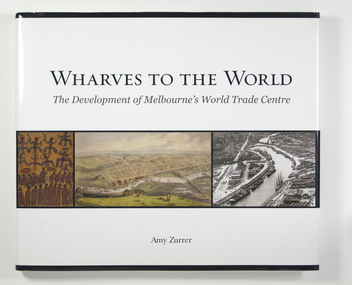
Book, Melbourne Books, Wharves To The World: The Development Of Melbourne's World Trade Centre, 2011
Wharves to the World: The Development of Melbourne's World Trade Centre is a photographic chronicle of the history of the World Trade Centre and its surrounds. The book traces the journey of land and the buildings that occupied it - from its beginnings with the Wurundjeri people to its role as a trading hub in early Melbourne, then as the site of the modern-day World Trade Centre, and now as part of a flourishing residential and commercial Precinct. As with any major project The World Trade Centre has face its share of fêlures, but despite thèse it has become an integral part of the City. So it goes that was once home to swampland and the City morgue has been transformer into a Diamond of the Yarra River.A 128-page book of printed matter, photographs, engravings and drawings. The hard cover is white with the title in gold lettering on the front. The dust-cover is also white with black lettering. Along the lower half of the cover, front and back, is a strip of six photos, three coloured and three black and white. 128 p. : ill. (some col.), ports. ; 22 x 25 cm.non-fictionWharves to the World: The Development of Melbourne's World Trade Centre is a photographic chronicle of the history of the World Trade Centre and its surrounds. The book traces the journey of land and the buildings that occupied it - from its beginnings with the Wurundjeri people to its role as a trading hub in early Melbourne, then as the site of the modern-day World Trade Centre, and now as part of a flourishing residential and commercial Precinct. As with any major project The World Trade Centre has face its share of fêlures, but despite thèse it has become an integral part of the City. So it goes that was once home to swampland and the City morgue has been transformer into a Diamond of the Yarra River.yarra yarra tribe, early melbourne, world trade centre, melbourne, southbank, northbank, australian wharf, siddeley street, waterfront, amy zurrer, wurundjeri, spencer street bridge, north wharf, riverlee, wtc, wharf, harbor trust, sir john coode, harbour trust, little dock, polly woodside, wharfies, divers -
 Tatura Irrigation & Wartime Camps Museum
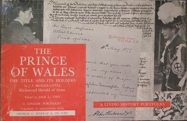
Portfolio, The Prince of Wales. The Title and its Holders
A portfolio containing documents, photographs, letters and articles pertaining to "The Prince of Wales" over the years. Printed in Great Britain.A landscape cardboard folder which opens up to show the pages being held inside. Front cover has a red square in bottom left with white writing giving title of folder, (The Prince of Wales The Title and its Holders), whom written by (J P Brooke-Little Richmond Herald of Arms), edited by Jack Le Vien. A Giniger Portfolio. Published in association with George G Harrap & Co. Ltd. Above red square is a picture of Prince Charles. In middle is a copy of two documents. On right side Prince Charles in ceremonial dress. Across the two documents in middle is a red square with white writing "A Living History Portfolio". Back page is red with a white rectangle which lists the contents of the portfolio. Inside is white.prince of wales, richmond herald of arms, j p brooke-little, jack le vien, giniger portfolio, george g harrap & co ltd, ian deaville -
 Bendigo Military Museum
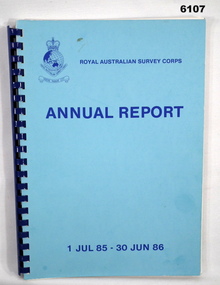
Administrative record - Royal Australian Survey Corps Annual Report 1 Jul 85 - 30 Jun 86, DSvy - A, RASvy Corps, Report on activities 1 Jul 85 - 30 Jun 86, Circa 1986
The status of RASVY activities (for the dates shown) in field surveying, mapping and charting is given in this report and is shown pictorially in the Annexes to the reportBlue book, plastic ring binder, Map and Chart production 85-86, Annexes graphically depicting map productionroyal australian survey corps, rasvy, fortuna, army survey regiment, army svy regt, asr -
 Greensborough Historical Society
Book, Melbourne Water, Plenty River Waterway Management Activity Plan 2000, 2000_
This report covers the catchment of the Plenty River from its upper reaches in the Great Dividing Range to the confluence with the Yarra River at Viewbank. It discusses ecological diversity and methods of improving water quality and significant areas of the catchment. Includes a brief history of settlement along the Plenty River.This is a significant plan for the improvement of the Plenty River.207 p., maps, folding maps. Printed on white paper with black spiral binding and clear plastic front cover.plenty river, melbourne water -
 Federation University Historical Collection
Map, Railway Map of Victoria, 1930
Cardboard map of Victorian railway system in 1930. Maps out all train-lines in Victoria and into New South Wales. map, railway, train-lines, victoria, victorian railways, railway lines -
 Bendigo Historical Society Inc.
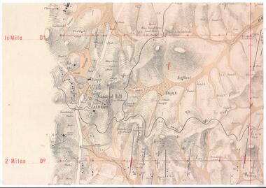
Map - DIAMOND HILL AREA
Copy of map of Diamond Hill area, with the Trig Station mid centre on map. Shafts, mines and geological features are marked.bendigo, mining, diamond hill -
 Bendigo Historical Society Inc.
Map - JACK FLYNN COLLECTION: COUNTY OF GLADSTONE, 1934
Map: County of Gladstone, map sheet showing the whole of the County and the Parishes within. Scale 2 Miles to 1 inch.Engraved at the Department of Lands and Survey Melbourne. 1958. By Authority of W.M. Houston, Government Printermap, gladstone, parish plan, gladstone -
Bendigo Historical Society Inc.
Map - PART PARISHES OF SANDHURST MARONG AND NERRING, No date visible
Map: Section of a Parish plan of Bendigo, covering Ironbark, Eaglehawk and Myers Flat ( number 145 in Map Cupboard 1)map, bendigo, city streets, parish of sandhurst, parish of marong, parish of nerring, ironbark, eaglehawk, myers flat -
Bendigo Historical Society Inc.
Map - BENDIGO IRRIGATION SETTLEMENT, 12/02/1908
Map: Plan of Bendigo Irrigation Settlement, Parishes of Sandhurst and Wellsford, County of Bendigo ( number 160 in Map Cupboard 1)map, bendigo, irrigation settlement, bendigo irrigation settlement, parishes of sandhurst and wellsford, county of bendigo -
Bendigo Historical Society Inc.
Map - TOWNSHIP OF KANGAROO FLAT, 27/01/1932
Map: Township of Kangaroo flat, Parish of Sandhurst , County of Bendigo. Parish plan ( number 194 in Map Cupboard 1)map, bendigo, township, kangaroo flat -
Bendigo Historical Society Inc.
Map - BOROUGH OF EAGLEHAWK, 30/11/1931
Map: Borough of Eagle hawk, Parish of Nerring. Parish plan with coloured areas ( number 185 in Map Cupboard 1)map, bendigo, parish plan, borough of eaglehawk, parish of nerring -
Bendigo Historical Society Inc.
Map - TARNAGULLA (PARTS), Circa 1880's
Map: Compilation of 3 hand draughted parish plans showing portions of Tarnagulla (number 261 in map cupboard 1)map, parish plan, tarnagulla -
Bendigo Historical Society Inc.
Map - TOWNSHIP OF HEATHCOTE (PART), 11/04/1935
Map: Township of Heathcote (part), Parish of Heathcote, County of Dalhousie. Parish plan (number 259 in map cupboard 1)map, dalhousie, township, heathcote, copunty of dalhousie -
Bendigo Historical Society Inc.
Map - HUNTLY (PART) RESURVEY, Circa 1877
Map: Huntly [part) resurvey, Parish of Huntly, County of Bendigo. Parish plan ( number 243 in Map Cupboard 1)map, bendigo, parish plan, huntly -
Bendigo Historical Society Inc.
Map - PARISH OF EPPALOCK RESURVEY, 23/05/1876
Map: Parish of Eppalock resurvey, County of Bendigo, hand draughted Parish plan ( number 240 in Map Cupboard 1)map, bendigo, parish plan, eppalock, resurvey -
Bendigo Historical Society Inc.
Map - SANDHURST (PART), Circa 1880's
Map: Parish plan showing the area Specimen Hill Road and Inglewood St. ( number 222 in Map Cupboard 1)map, bendigo, parish plan, specimen hill rd. inglewood st. -
Bendigo Historical Society Inc.
Map - WESTON, 21/10/1876
Map: Re-Survey of part of the parish of Weston, County of Rodney. Parish plan (number 309 in map cupboard 1)Murray and Hargreave, Authorised surveyorsmap, rodney, parish plan, parish of weston, murray and hargreave -
Bendigo Historical Society Inc.
Map - BENDIGO, October 1st 1893
Map: Plan of the whole County of Bendigo, Showing areas now available for Selection (number 340 in map cupboard 1)map, bendigo, lands for selection, county of bendigo, areas available for selection -
Bendigo Historical Society Inc.
Map - GRAZING ALLOTMENTS, 15/10/1894
Map: Grazing Allotments, Parishes of Whirrakee and Bagshot, County of Bendigo. Parish plan (number 331 in map cupboard 1)map, bendigo, grazing allotments, grazing allotments, whirrakee, bagshot -
Koorie Heritage Trust
Book, Beauglehole, A. C, The Distribtion and Conservation of Vascular Plants in the South Gippsland area, Victoria, 1984
i-iii; 90 P.; fold-out map on end-cover; tables; maps; ill.; appendices.21 cm.south gippsland, vic.-fauna and flora. -
Whitehorse Historical Society Inc.
Map, City of Nunawading, c1975
Map of City of Nunawading, showing location of 186 parks and reserves.Map of City of Nunawading, showing location of 186 parks and reserves. Scale 1:10,000 with list of streets and their map coordinates.Map of City of Nunawading, showing location of 186 parks and reserves. city of nunawading, parks and reserves -
 Bendigo Historical Society Inc.
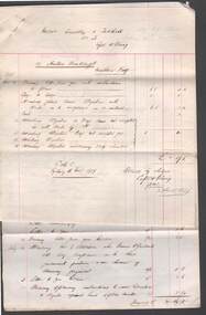
Document - CONNELLY, TATCHELL, DUNLOP COLLECTION: DOCUMENTS RE COPE & KING
3 documents pinned together, on top of documents messrs Connelly Tatchell & Dunlop 'Dr. to Cope & King', names mentioned in documents : Anders ( bankrupt ) Smith & Boyd., Colonial Bank versus Joachim, Shannon versus Haylock, dated 23rd. November, 1889. On top of folded documents, on outside, 23 Nov 1889, Cope & King.business, legal, connelly, tatchell & dunlop -
 Phillip Island and District Historical Society Inc.
Badge, Circular Cloth Badges
Badges issued by the Shire of Phillip Island prior to 1994Historical2 Circular Cloth Badges for Shire of Phillip Island - 1 printed and the other embroideredShire of Phillip Island. Map of Phillip Island, Penguin, Banksia & Eucalypt leaves. shire of phillip island -
 Bendigo Military Museum
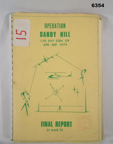
Administrative record - Operation Report - Operation Sandy Hill 1Fd Svy Sqn Apr - Sep 1975, 1 Fd Svy Sqn, 1976
Comprehensive Operation Report on Operation Sandy Hill conducted by 1Fd Svy Sqn Apr-Sep 1975 Part 1 Forward, Part 2 Planning and Mounting, Part 3 Final Report OC 1 Fd Svy Sqn, Part 4 Report Abn/EDM Gp, Part 5 Report Recon, Stn Marking and Traversing Gp, Part 6 Admin Report, Part 7 Report OC 171 Op Spt Sqn, Part 8 Computations and Results, Part 9 Observations and Recommendations.A4 size report held together with a plastic spiral binding, Light Cardboard cover includes many foldout Annexes"15" on front cover. Rubber stamp "Army Survey Regiment Map Library"royal australian survey corps, rasvy, fortuna, army survey regiment, army svy regt, asr -
 Mission to Seafarers Victoria
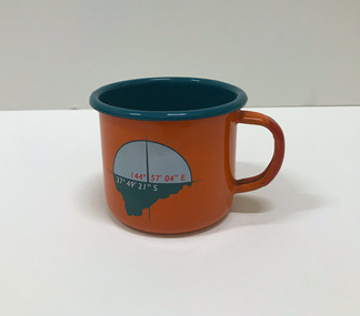
Souvenir - Cup, Margaret Woodward, 2015
Margaret Woodward is a an artist and an an associate professor of design at Charles Sturt University. Artist statement: "The Sea is All Around us is a multi-layered event which creates a memorable experience for those visiting the Dome Gallery and the Mission to Seafarers in Melbourne’s Docklands. The event acknowledges and raises awareness of the often difficult and dangerous working lives and journeys of seafarers by making visible their role in transporting commodities, materials and objects to and from Australia’s shores. This installation at the Dome Gallery in the Mission to Seafarers in Melbourne’s Docklands marks the third stage of an ongoing research project which seeks to reveal the ‘social life’ of souvenirs. Beyond their representational role souvenirs also trigger intangible, affective qualities – reminders of journeys and places, new associations with tastes, sounds and people, and thereby becoming objects which focus and hold memories. This installation invites seafarers and visitors to participate in a global project which aims to witness sea journeys and trace the mobile life of seafarers and souvenirs. For a fortnight in May 2015, the Dome Gallery became an architectural large scale compass, with the circular floor marking the intersection of its latitude and longitude (37 º 49'21" S 144º 57'03"E). Over these two weeks the Dome Gallery was inscribed with marks recording journeys made by seafarers, recording destination and departure ports, home lands and waterways, and in doing so making visible a small segment of the global patterns of seafaring. Custom-made souvenirs designed for the installation are given to seafarers as gestures of welcome and a memento of their visit. The souvenirs originating in Poland continue their journey by sea, to destinations beyond the Dome becoming part of the global network of seafaring, with an invitation for seafarers to record their future journeys using QR code scanning technologies. It is hoped that by releasing the 200 limited edition souvenirs accompanying the seafarers the mobile life of souvenirs and seafarers will also become visible. Like messages in bottles they leave our shores, becoming ambassadors, representing the Dome Gallery at the Mission to Seafarers, the waters of Port Phillip Bay, Australia’s red soil and vegetation, and carrying memories of visiting Melbourne." The Mission has always been open to the community and has a tradition of hosting cultural events: shows, concerts, exhibitions, festivals.Orange enamel and teal mug created for the art installation by artist Margaret Woodward at the Mission to Seafarers. On one side it is decorated with a compass and a latitude and longitude; on the opposite side, a leaf, a QR code on the bottom takes you to the website.Written at the bottom of the mug: Please scan to map the journey of this souvenir * www.sensingtheremote.net *2015cultural events, norla dome, mso, 2015, art installation, margaret woodward -
 Greensborough Historical Society
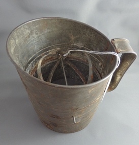
Flour Sifter, Kande, Metal flour sifter, 1954c
This sifter was used at Poulter Avenue Greensborough for over 55 years.Owned and used by the Colvin family for over 55 years.Metal sifter with metal handle and green painted winder. Some rust damage and a hole in wire."Kande" brand inside outline map of Australia, stamped on side with patent information.flour sifter -
 Ringwood and District Historical Society
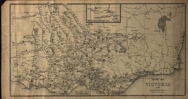
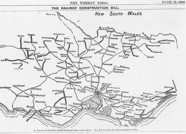
Photograph, Map showing Victoria's proposed railway system, 1890
Catalogue card reads, 'Map showing Victoria's proposed railway system, 1890. -
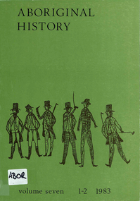 Victorian Aboriginal Corporation for Languages
Periodical, Australian National University Department of Pacific and Southeast Asian History, Aboriginal history, 1983
maps, b&w photographs, b&w illustrations, tables, sheet music