Showing 432 items
matching victoria avenue
-
 Ballarat Heritage Services
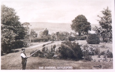
Photograph - Postcard, Wombat Hill Gardens, Daylesford
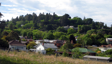
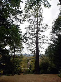
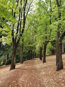
The Daylesford Botanic Gardens are of historic, scientific (botanic), and aesthetic significance to the State of Victoria. The Daylesford Botanic Gardens are historically significant as a fine example of a regional botanic garden demonstrating the typical characteristics of a carriage drive, informal park layout, decorative structures and works such as the memorial tower, conservatory, rotunda, cascade and fernery, which contrasts with the open lawns planted with specimen trees, areas of intensive horticultural interest and close proximity to a township developed during the mid to late nineteenth century. The Daylesford Botanic Gardens are historically significant for the design input by noted landscape designer William Sangster, and for the survival of his 1884 plan, which is a rare example of a plan from this prolific garden designer. The Daylesford Botanic Gardens are of scientific (botanic) significance for the extensive conifer collection and cool climate plants. The Gardens contain an outstanding collection of conifers and other mature trees, many of which were donated by renowned botanist Ferdinand von Mueller. Significant trees include Pinus ponderosa (Western Yellow Pine), Pinus coulteri (Big Cone Pine), twoAbies nordmanniana (Caucasian Fir), Abies pinsapo, (Spanish Fir) and a Cedrus atlantica f. glauca(Blue Atlas Cedar), Pinus wallichiana (Bhutan Pine), Pinus pinaster (Maritime Pine), Sequoiadendron giganteum (Giant Redwood), (Monkey Puzzle) and Aesculus hippocastanum (Horse Chestnut), many the largest or finest examples in Victoria. Other outstanding trees include a Tilia cordata (Small-leaved European Linden), a row of Cupressus lusitanica (Mexican cypress), a Quercus robur (English Oak) planted in 1863, avenues of Dutch Elms and a rare Quercus leucotrichophora (Himalayan Oak). The Daylesford Botanic Gardens are of aesthetic significance as a rare example of a botanic garden spectacularly sited on an extinct volcanic cone which allows a panoramic view, aided by the 1938 Pioneers’ Memorial Tower, as well as vistas within and out of the gardens and from the township to the gardens. As the most prominent local landmark, the Garden’s vertical dominance in the landscape provides a dark contrast to the elms avenues, oaks and other deciduous species. (Heritage Victoria Register, )Black and white postcard of Wombat Hill Botanical Gardens, Daylesford.wombat hill botanical gardens, daylesford, gardener, wombat hill botanic gardens -
 Ballarat Heritage Services
Photograph - Digital photographs, L.J. Gervasoni, Wombat Hill Botanic Gardens 150 anniversary event Daylesford community event, 2013
The Daylesford Botanic Gardens are of historic, scientific (botanic), and aesthetic significance to the State of Victoria. The Daylesford Botanic Gardens are historically significant as a fine example of a regional botanic garden demonstrating the typical characteristics of a carriage drive, informal park layout, decorative structures and works such as the memorial tower, conservatory, rotunda, cascade and fernery, which contrasts with the open lawns planted with specimen trees, areas of intensive horticultural interest and close proximity to a township developed during the mid to late nineteenth century. The Daylesford Botanic Gardens are historically significant for the design input by noted landscape designer William Sangster, and for the survival of his 1884 plan, which is a rare example of a plan from this prolific garden designer. The Daylesford Botanic Gardens are of scientific (botanic) significance for the extensive conifer collection and cool climate plants. The Gardens contain an outstanding collection of conifers and other mature trees, many of which were donated by renowned botanist Ferdinand von Mueller. Significant trees include Pinus ponderosa (Western Yellow Pine), Pinus coulteri (Big Cone Pine), twoAbies nordmanniana (Caucasian Fir), Abies pinsapo, (Spanish Fir) and a Cedrus atlantica f. glauca(Blue Atlas Cedar), Pinus wallichiana (Bhutan Pine), Pinus pinaster (Maritime Pine), Sequoiadendron giganteum (Giant Redwood), (Monkey Puzzle) and Aesculus hippocastanum (Horse Chestnut), many the largest or finest examples in Victoria. Other outstanding trees include a Tilia cordata (Small-leaved European Linden), a row of Cupressus lusitanica (Mexican cypress), a Quercus robur (English Oak) planted in 1863, avenues of Dutch Elms and a rare Quercus leucotrichophora (Himalayan Oak). The Daylesford Botanic Gardens are of aesthetic significance as a rare example of a botanic garden spectacularly sited on an extinct volcanic cone which allows a panoramic view, aided by the 1938 Pioneers’ Memorial Tower, as well as vistas within and out of the gardens and from the township to the gardens. As the most prominent local landmark, the Garden’s vertical dominance in the landscape provides a dark contrast to the elms avenues, oaks and other deciduous species. (Heritage Victoria Register, )Digital imagesvictoria, 150, anniversary, botanic, gardens, wombat hill, botanic gardens, heritage, celebration, garden party, daylesford, people, crowd, community, john hawker, john madigan, stilt, trees, owls, wombat hill botanic gardens -
 Ballarat Heritage Services
Photograph - digital photographs, Lisa Gervasoni, Wombat Hill, Daylesford, c2006-2016
The Daylesford Botanic Gardens are of historic, scientific (botanic), and aesthetic significance to the State of Victoria. The Daylesford Botanic Gardens are historically significant as a fine example of a regional botanic garden demonstrating the typical characteristics of a carriage drive, informal park layout, decorative structures and works such as the memorial tower, conservatory, rotunda, cascade and fernery, which contrasts with the open lawns planted with specimen trees, areas of intensive horticultural interest and close proximity to a township developed during the mid to late nineteenth century. The Daylesford Botanic Gardens are historically significant for the design input by noted landscape designer William Sangster, and for the survival of his 1884 plan, which is a rare example of a plan from this prolific garden designer. The Daylesford Botanic Gardens are of scientific (botanic) significance for the extensive conifer collection and cool climate plants. The Gardens contain an outstanding collection of conifers and other mature trees, many of which were donated by renowned botanist Ferdinand von Mueller. Significant trees include Pinus ponderosa (Western Yellow Pine), Pinus coulteri (Big Cone Pine), twoAbies nordmanniana (Caucasian Fir), Abies pinsapo, (Spanish Fir) and a Cedrus atlantica f. glauca(Blue Atlas Cedar), Pinus wallichiana (Bhutan Pine), Pinus pinaster (Maritime Pine), Sequoiadendron giganteum (Giant Redwood), (Monkey Puzzle) and Aesculus hippocastanum (Horse Chestnut), many the largest or finest examples in Victoria. Other outstanding trees include a Tilia cordata (Small-leaved European Linden), a row of Cupressus lusitanica (Mexican cypress), a Quercus robur (English Oak) planted in 1863, avenues of Dutch Elms and a rare Quercus leucotrichophora (Himalayan Oak). The Daylesford Botanic Gardens are of aesthetic significance as a rare example of a botanic garden spectacularly sited on an extinct volcanic cone which allows a panoramic view, aided by the 1938 Pioneers’ Memorial Tower, as well as vistas within and out of the gardens and from the township to the gardens. As the most prominent local landmark, the Garden’s vertical dominance in the landscape provides a dark contrast to the elms avenues, oaks and other deciduous species. (Heritage Victoria Register, )Colour photograph of Wombat Hill Botanical Gardens, Daylesford.heritage, daylesford, townscape, wombat hill, wombat hill botanical gardens, wombat hill botanic gardens -
 Ballarat Heritage Services
Photograph - Digital photographs, L.J. Gervasoni, Wombat Hill in the Fog, c2015
... Central Springs Avenue, Daylesford, Victoria, Australia ...The Daylesford Botanic Gardens are of historic, scientific (botanic), and aesthetic significance to the State of Victoria. The Daylesford Botanic Gardens are historically significant as a fine example of a regional botanic garden demonstrating the typical characteristics of a carriage drive, informal park layout, decorative structures and works such as the memorial tower, conservatory, rotunda, cascade and fernery, which contrasts with the open lawns planted with specimen trees, areas of intensive horticultural interest and close proximity to a township developed during the mid to late nineteenth century. The Daylesford Botanic Gardens are historically significant for the design input by noted landscape designer William Sangster, and for the survival of his 1884 plan, which is a rare example of a plan from this prolific garden designer. The Daylesford Botanic Gardens are of scientific (botanic) significance for the extensive conifer collection and cool climate plants. The Gardens contain an outstanding collection of conifers and other mature trees, many of which were donated by renowned botanist Ferdinand von Mueller. Significant trees include Pinus ponderosa (Western Yellow Pine), Pinus coulteri (Big Cone Pine), twoAbies nordmanniana (Caucasian Fir), Abies pinsapo, (Spanish Fir) and a Cedrus atlantica f. glauca(Blue Atlas Cedar), Pinus wallichiana (Bhutan Pine), Pinus pinaster (Maritime Pine), Sequoiadendron giganteum (Giant Redwood), (Monkey Puzzle) and Aesculus hippocastanum (Horse Chestnut), many the largest or finest examples in Victoria. Other outstanding trees include a Tilia cordata (Small-leaved European Linden), a row of Cupressus lusitanica (Mexican cypress), a Quercus robur (English Oak) planted in 1863, avenues of Dutch Elms and a rare Quercus leucotrichophora (Himalayan Oak). The Daylesford Botanic Gardens are of aesthetic significance as a rare example of a botanic garden spectacularly sited on an extinct volcanic cone which allows a panoramic view, aided by the 1938 Pioneers’ Memorial Tower, as well as vistas within and out of the gardens and from the township to the gardens. As the most prominent local landmark, the Garden’s vertical dominance in the landscape provides a dark contrast to the elms avenues, oaks and other deciduous species. (Heritage Victoria Register, )Black and white photograph of a treed landscape covered with fog. The trees are in the Daylesford Botanical Gardens on Wombat Hill.wombat hill botanic gardens, wombat hill, daylesford, daylesford botanic gardens, fog, weather, arboretum -
 Ballarat Heritage Services
Photograph - Photograph - Colour, Clare Gervasoni, Wombat Botanic Gardens, Daylesford, 2019, 23/04/2019
The Daylesford Botanic Gardens are of historic, scientific (botanic), and aesthetic significance to the State of Victoria. The Daylesford Botanic Gardens are historically significant as a fine example of a regional botanic garden demonstrating the typical characteristics of a carriage drive, informal park layout, decorative structures and works such as the memorial tower, conservatory, rotunda, cascade and fernery, which contrasts with the open lawns planted with specimen trees, areas of intensive horticultural interest and close proximity to a township developed during the mid to late nineteenth century. The Daylesford Botanic Gardens are historically significant for the design input by noted landscape designer William Sangster, and for the survival of his 1884 plan, which is a rare example of a plan from this prolific garden designer. The Daylesford Botanic Gardens are of scientific (botanic) significance for the extensive conifer collection and cool climate plants. The Gardens contain an outstanding collection of conifers and other mature trees, many of which were donated by renowned botanist Ferdinand von Mueller. Significant trees include Pinus ponderosa (Western Yellow Pine), Pinus coulteri (Big Cone Pine), twoAbies nordmanniana (Caucasian Fir), Abies pinsapo, (Spanish Fir) and a Cedrus atlantica f. glauca(Blue Atlas Cedar), Pinus wallichiana (Bhutan Pine), Pinus pinaster (Maritime Pine), Sequoiadendron giganteum (Giant Redwood), (Monkey Puzzle) and Aesculus hippocastanum (Horse Chestnut), many the largest or finest examples in Victoria. Other outstanding trees include a Tilia cordata (Small-leaved European Linden), a row of Cupressus lusitanica (Mexican cypress), a Quercus robur (English Oak) planted in 1863, avenues of Dutch Elms and a rare Quercus leucotrichophora (Himalayan Oak). The Daylesford Botanic Gardens are of aesthetic significance as a rare example of a botanic garden spectacularly sited on an extinct volcanic cone which allows a panoramic view, aided by the 1938 Pioneers’ Memorial Tower, as well as vistas within and out of the gardens and from the township to the gardens. As the most prominent local landmark, the Garden’s vertical dominance in the landscape provides a dark contrast to the elms avenues, oaks and other deciduous species. (Heritage Victoria Register, )A tree in the Wombat Hill Gardens.wombat botanical gardens, daylesford botanical gardens, daylesford, trees, wombat hill botanic gardens -
 Ballarat Heritage Services
Photograph - Photograph - Colour, Clare Gervasoni, Wombat Botanic Gardens, Daylesford, 2019, 23/04/2019
The Daylesford Botanic Gardens are of historic, scientific (botanic), and aesthetic significance to the State of Victoria. The Daylesford Botanic Gardens are historically significant as a fine example of a regional botanic garden demonstrating the typical characteristics of a carriage drive, informal park layout, decorative structures and works such as the memorial tower, conservatory, rotunda, cascade and fernery, which contrasts with the open lawns planted with specimen trees, areas of intensive horticultural interest and close proximity to a township developed during the mid to late nineteenth century. The Daylesford Botanic Gardens are historically significant for the design input by noted landscape designer William Sangster, and for the survival of his 1884 plan, which is a rare example of a plan from this prolific garden designer. The Daylesford Botanic Gardens are of scientific (botanic) significance for the extensive conifer collection and cool climate plants. The Gardens contain an outstanding collection of conifers and other mature trees, many of which were donated by renowned botanist Ferdinand von Mueller. Significant trees include Pinus ponderosa (Western Yellow Pine), Pinus coulteri (Big Cone Pine), twoAbies nordmanniana (Caucasian Fir), Abies pinsapo, (Spanish Fir) and a Cedrus atlantica f. glauca(Blue Atlas Cedar), Pinus wallichiana (Bhutan Pine), Pinus pinaster (Maritime Pine), Sequoiadendron giganteum (Giant Redwood), (Monkey Puzzle) and Aesculus hippocastanum (Horse Chestnut), many the largest or finest examples in Victoria. Other outstanding trees include a Tilia cordata (Small-leaved European Linden), a row of Cupressus lusitanica (Mexican cypress), a Quercus robur (English Oak) planted in 1863, avenues of Dutch Elms and a rare Quercus leucotrichophora (Himalayan Oak). The Daylesford Botanic Gardens are of aesthetic significance as a rare example of a botanic garden spectacularly sited on an extinct volcanic cone which allows a panoramic view, aided by the 1938 Pioneers’ Memorial Tower, as well as vistas within and out of the gardens and from the township to the gardens. As the most prominent local landmark, the Garden’s vertical dominance in the landscape provides a dark contrast to the elms avenues, oaks and other deciduous species. (Heritage Victoria Register, 2025)An avenue of trees in the Wombat Hill Gardens. wombat botanical gardens, daylesford botanical gardens, daylesford, trees -
 Ballarat Heritage Services
Photograph - Photograph - Colour, Clare Gervasoni, Wombat Botanic Gardens, Daylesford, 2019, 23/04/2019
The Daylesford Botanic Gardens are of historic, scientific (botanic), and aesthetic significance to the State of Victoria. The Daylesford Botanic Gardens are historically significant as a fine example of a regional botanic garden demonstrating the typical characteristics of a carriage drive, informal park layout, decorative structures and works such as the memorial tower, conservatory, rotunda, cascade and fernery, which contrasts with the open lawns planted with specimen trees, areas of intensive horticultural interest and close proximity to a township developed during the mid to late nineteenth century. The Daylesford Botanic Gardens are historically significant for the design input by noted landscape designer William Sangster, and for the survival of his 1884 plan, which is a rare example of a plan from this prolific garden designer. The Daylesford Botanic Gardens are of scientific (botanic) significance for the extensive conifer collection and cool climate plants. The Gardens contain an outstanding collection of conifers and other mature trees, many of which were donated by renowned botanist Ferdinand von Mueller. Significant trees include Pinus ponderosa (Western Yellow Pine), Pinus coulteri (Big Cone Pine), twoAbies nordmanniana (Caucasian Fir), Abies pinsapo, (Spanish Fir) and a Cedrus atlantica f. glauca(Blue Atlas Cedar), Pinus wallichiana (Bhutan Pine), Pinus pinaster (Maritime Pine), Sequoiadendron giganteum (Giant Redwood), (Monkey Puzzle) and Aesculus hippocastanum (Horse Chestnut), many the largest or finest examples in Victoria. Other outstanding trees include a Tilia cordata (Small-leaved European Linden), a row of Cupressus lusitanica (Mexican cypress), a Quercus robur (English Oak) planted in 1863, avenues of Dutch Elms and a rare Quercus leucotrichophora (Himalayan Oak). The Daylesford Botanic Gardens are of aesthetic significance as a rare example of a botanic garden spectacularly sited on an extinct volcanic cone which allows a panoramic view, aided by the 1938 Pioneers’ Memorial Tower, as well as vistas within and out of the gardens and from the township to the gardens. As the most prominent local landmark, the Garden’s vertical dominance in the landscape provides a dark contrast to the elms avenues, oaks and other deciduous species. (Heritage Victoria Register, 2025)A large tree in the Wombat Gardens. wombat botanical gardens, daylesford botanical gardens, daylesford, trees, lisa gervasoni, wombat botanic gardens -
 Ringwood and District Historical Society
Document - Research Notes, Richard Carter, Land Subdivisions in Ringwood 1890-1950
Handwritten table listing main local pre-1950s subdivisions in the Ringwood area, with estate names, streets, number of allotments for sale, and where known, vendor agent, LP (Lodged Plan) title registration number, and auction/sale date, some with sale price.Pg1 RINGWOOD STATION ESTATE LP3070 (Year?) Station Street, William Street (now Kendall Street), Wantirna Road, Station Street Pg1 RINGWOOD TOWNSHIP ESTATE LP5577 (1913) Station Road (now Warrandyte Road), Pratt Street (part now Aird Street), Whitehorse Road Pg2 RINGWOOD ORCHARD ESTATE LP4315 (1914) Brysons Road, Hillcrest Road, Anzac Avenue, Sulva Road Pg3 RINGWOOD RAILWAY ESTATE LP7522 (1918) Whitehorse Road (now Mount Dandenong Road), Dublin Road, Freeman Street, Patterson Street, Bona Street Pg4 THE RINGWOOD ESTATE LP7578 (1919) Warrandyte Road, Hobart Street, Paxton Street, Arnold Street Pg5 GARDEN FARMS ESTATE (LP?) (1919) Canterbury Road, Armstrong Road, Bungalook Road, Orchard Road, Bayswater Road (now Mountain Highway) Pg6 THE RINGWOOD ESTATE (SECOND SUB-DIVISION) LP7604 (1919) Warrandyte Road, Tamar Street, Derwent Street, Mersey Street Pg7 RINGWOOD STATION ESTATE LP7703 (1919) Bedford Road, Williams Grove (now Lena Grove) Pg8 RINGWOOD TOWNSHIP ESTATE LP8198 (1919) Wantirna Road, Ellison Street, Haig Street, Greenwood Avenue Pg9 EASTFIELD ESTATE (LP?) (1920) Eastfield Road, Longview Road, Pleasant Rise, The Mount Pg10 ELECTRIC RAILWAY ESTATE RINGWOOD LP9473 (1922) Campbell Street, Myrtle Avenue, George Street (now Tudor Court), Henry Street (now Myrtle Avenue), Williams Grove (now Lena Grove) Pg11 RINGWOOD PARK ESTATE LP7884 (1922 - two stages) Wonga Road (now Loughnan Road), William Street, Andrew Street, Harrison Street Pg12 HEATHMONT STATION ESTATE LP11009 (Date? - after 1922) Lisgoold Street, Viviani Crescent, Balrour Avenue, Station Street (now part Heathmont Road and part Wainui Street) Pg13 RINGWOOD RAILWAY ESTATE LP10507 (1923) Whitehorse Road, Sherbrooke Avenue, Burwood Avenue, Bonview Avenue, Heatherbrae Avenue, Grant Crescent Pg14 GARDEN HOMES ESTATE (LP?) (1923) Mullum Road, The Centreway, Wattle Crescent (now Wattle Avenue) Reserve Crescent (now Reserve Road) Pg15 DUBLIN ROAD ESTATE LP11993 (1923) Alexandra Road, Vonadawn Avenue, Green Street, Wood Street, Howard Avenue, Bedford Road, Dublin Road Pg16 CARLINGA ESTATE RINGWOOD LP9620 (1923) Bourke Street, Bond Street, Ringwood Street Pg17 PRATT'S JUNCTION ESTATE (LP?) (1923) Junction Street, Georges Road, Oliver Street, Whitehorse Road Pg18 EAST RINGWOOD ESTATE LP10492 (1923) Bona Street, Patterson Street, Miller Grove, Fairview Avenue, Eastfield Road, Whitehorse Road (now Mount Dandenong Road) Pg19 COLEMAN'S HEATHMONT ESTATE LP9974 (1923) Canterbury Road, Bedford Road, Alvena Crescent, Coleman Street, Leonard Street (now Royal Avenue) Pg20 RINGWOOD HEIGHTS ESTATE LP10506 (1924) Whitehorse Road, Bonview Avenue, Grant Crescent, Hillcrest Avenue, Heatherbrae Avenue, Margaret Street, Mary Street Pg21 EAST RINGWOOD STATION ESTATE LP10551 (1924) Knaith Road, Wenwood Street, Lois Street, Victoria Street, Station Street (now Railway Avenue) Pg22 GRAND VIEW ESTATE LP11019 (1924) Whitehorse Road, Rupert Street, Herbert Street, Leonard Street Pg23 RINGWOOD RAILWAY ESTATE & RINGWOOD HEIGHTS ESTATE - FINAL SECTIONS LP10506 & LP10507 (1924) Whitehorse Road, Sherbrooke Avenue, Burwood Avenue, Bonview Avenue, Heatherbrae Avenue, Margaret Street, Mary Street, Grant Crescent Pg24 RINGWOOD EAST ELECTRIC STATION ESTATE (LP?) (1924) Railway Parade (now Patterrson Street), Federal Road, Howship Avenue (part now French Street), Dublin Road, Rosedale Crescent Pg25 BEDFORD PARK (now Ringwood Secondary College) (LP?) (1924) Bedford Road, Adams Street, Anderson Street, Joyce Street, Graham Road Pg26 CROWN JEWEL ESTATE LP11645 (Private sales after 1924) Mount Dandenong Road, Mirabel Avenue, Valda Avenue, Evon Avenue, Velma Grove Pg27 GRAND CENTRAL ESTATE LP10917 (1925) Heathmont Road, Great Ryrie Street, Douglas Street, Garden Street, Bellevue Avenue Pg28 RINGWOOD (unnamed estate - 1926) Nelson Street, Seymour Street, Whitehorse Road Pg29 EAST RINGWOOD RAILWAY STATION ESTATE (YEAR? - 25 shops 60 villas) Railway Avenue, Dublin Road, Lawrence Grove, Stanley Avenue, Knaith Road Pg30 CHARM VIEW ESTATE (LP?) (year? - after 1926) Canterbury Road, Heathmont Road, Dickasons Road, Bennjett Avenue, Orchid Street Pg31 SUNBEAM ESTATE LP12150 (Circa 1925) Govt Road (now Old Lilydale Road), Sunbeam Avenue, Holland Road, Everard Street (now Everard Road) Pg32 FAIRVIEW ESTATE EAST RINGWOOD LP10853 (Circa 1924) Eastfield Road, Patterson Street, Margaret Street (now Short Street) Pg33 EAST RINGWOOD TOWNSHIP ESTATE LP3025 (Circa 1924 - 35 allotments) Mount Dandenong Road, Grey Street, Eastfield Road Pg34 EAST RINGWOOD TOWNSHIP ESTATE LP3025 (Circa 1924 - 49 allotments) and STATE SCHOOL ESTATE (26 allotments) and EAST RINGWOOD STATION ESTATE (14 shop sites) Mount Dandenong Road, Grety Street, Dunn Street, Eastfield Road, King Street, Holland Road, Dublin Road, Patterson Street, Bona Street Pg35 EAST RINGWOOD CENTRAL ESTATE LP17004 (1948) Knaith Road, Shasta Avenue, Talofa Avenue, Russet Road, Dublin Road Pg36 WARE ESTATE LP43360 (1958) Ware Crescent, Davey Drive, Grey Road (now Grey Street), Mount Dandenong Road Pg37 Lot 57 Kendall Street LP3070 (1939) £75.0.0 Pg37 Lot 14 LP7346 (year?) £225 Pg37 Lot 8 WHITE HORSE ESTATE LP14010 (year?) Maroondah Hwy, Seymour Street £98.9.0 Pg37 Lots 4-14 incl. LP10902 (year?) £300 Pg37 Lots 69&70 LP2216 (1939) Bedford Road, Pitt Street £500 Pg37 Lots 60&70 LP2216 (year?) £460 Pg37 MOUNTAIN VIEW ESTATE LP10902 (1936) Lots 1&2, 19-22 Wantirna Road, Daisy Street £50 Pg38 RAILWAY STATION ESTATE RINGWOOD EAST LP7522 (1925) Lots 16 to 19 £250 Pg38 RINGWOOD PARK ESTATE (LP?) (1924) Lot 112 Munro Street £230 Pg38 RINGWOOD TOWNSHIP ESTATE (LP?) (1925) Lot 57 Wantirna Road £850 Pg38 ELECTRIC RAILWAY ESTATE LP9473 (1925) Lot 98 & 99 £180 (30/- foot) Pg38 ELECTRIC RAILWAY ESTATE LP9473 (year?) Lot 100 £233.12.6 incl improvements (£2.12.6 foot) Pg38 Lot 22&23 Bedford Road Heathmont (LP & year?) £675 incl improvements Pg39 Lot 9 Mullum Mullum Road LP8221 (1923) £150 Pg39 Lot 27 Haig Street LP8198 (1925) £825 Pg39 Lot 56 Haig Street cnr Wantirna Road LP8198 (1923) £171 Pg39 Lots 3 & 4 Loughnan Road LP9626 (192?) £147 Pg39 Lots 98 & 99 Myrtle Avenue LP9473 (1925) £180 Pg39 Lots 80 & 81 Myrtle Avenue LP9473 (1929) £150 Pg39 Lot 30 Sherbrooke Avenue LP10507 (1926) £700 incl improvements Pg40 Lot 10 (year?) LP7703 £750 Pg40 Lot 36 (year?) LP7522 £25 Pg40 Lot 38 Pitt Street LP2216 (year?) £350 Pg40 Lot 7 Dublin Road cnr Green Street LP11993 (year?) £300 -
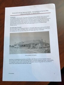 Surrey Hills Historical Society Collection
Vertical file, Frederick WiIliam Mawson of Surrey Hills, his family and descendants
Frederick William Mawson and his wife Mary (nee Mullard) and baby daughter, Beatrice Mary migrated to Victoria as steerage passengers, arriving in Melbourne on 1 July 1882 on the sailing ship the ‘Holmsdale’. They settled in Bona Vista Avenue, Surrey Hills (house demolished) and he established a jam factory in Boundary (Warrigal) Road. Further children of the family were Harriett, Muriel, Ethel, Winifred, John and Frederick William (Jnr). The later died in WW1 and there is a transcript of his diary in this collection. Four of the daughters became nurses, three serving in WW1. The other son John became a local builder, who after the war built 'Holmsdale' in Union Road as a convalescent home to be run by his sisters. After the death of his first wife Frederick (Snr) married Catherine Small, a widow with children of her own.The family were early settlers in Surrey Hills and their story in relation to the service of local men and women during WW1 is well documented.Vertical file of information related to the Mawson family which includes: 1. Notes and documents that came from John Howden via G Randy Johnston, his tenant at 257 Union Road, Surrey Hills. (6 pages in total): a. The Misses Mawson family history, written by John Howden (2 pages), b Note from G Randy Johnston, c. Passengers’ contract ticket for Fred, Mary & Beatrice Mawson on the ‘Holmsdale’, 1882, d. Photocopies of 2 photos of the ‘Holmsdale’, e. Invitation (blank photocopy) to the opening of ‘Holmsdale’ Convalescent Home, 257 Union Road, Surrey Hills, 14.3.1936. 2. Advertising brochure for ‘Holmsdale’ Convalescent Home (undated) (3 pages: original and photocopy x 2). 3. English family documents (8 pages): a. John Spensley Barnsdall bapt Mar 1818, b. John Spensley Barnsdall marriage registration, c. Census 1861 for John Mawson, Betsy Bradbury Mawson, Frederick William Mawson and George Barnesdale Mawson, d. Census 1871 for John Mawson, Betsy B. Mawson, Frederick W. Mawson and George B. Mawson and Arthur Mawson, e. Census 1881 for John Mawson, Betsy B. Mawson, Arthur Mawson and George Mawson, f. Census 1881 for Fredk W Mawson and Mary Mawson. 4. PROV Unassisted passenger list information for Mary Mawson 1882 (1 page). 5. Mawson family members notes compiled by Sue Barnett (2 pages). 6. Harriet Godden Mawson details including WW1 service details, Royal Military College of Australia certificate of service certificate, references from Duntroon and Gresswell Sanatorium (11 pages). 7. Beatrice Mawson details including WW1 service on the ‘Mongolia’ – Argus article 28 June 1917 and her account of the sinking of the ‘Mongolia’ published in Castlemaine newspaper, 18 August 1917 (4 pages). 8. Muriel Mawson details including WW1 service and evidence of her training at Castlemaine Hospital (5 pages). 9. F.W. Mawson Jr details including WW1 service including Red Cross Wounded and Missing Enquiry Bureau file and Dasey (misnamed photo of him) (8 pages, incl photo). 10. F.W. Mawson Snr details incl birth registration, 1871, marriage to Catherine Small, death registration, cemetery index (5 pages). 11. Betsy Bradbury Mawson death & burial details (2 pages). 12. John Mawson family: John Mawson probate notice, 24 Sept 1941; marriage of son Ivan to Joan Manning, 29/9/1945 (2 pages). 13. Arthur David Mawson details - extract from Ancestry.com family tree notated by Sue Barnett; death notice from The Argus, 24 oct 1939 (2 pages). 14. Holmsdale and the Mawson family - Presentation to Surrey Hills Historical Society: 21 March 2012 by Sue Barnett, 25 pages including photos. 15. Letter from John Howden to Sue Barnett, 1 April 2012. 16. Information re Dr James Moore Andrew of Yallourn.(mr) frederick william mawson, (mr) john howden, (mr) frederick william mawson jnr, aif, (miss) beatrice mary mawson, (miss) harriet godden mawson, (miss) muriel mawson, (mr) john mawson, (miss) ethel mawson, (miss) winifred sarah mawson, (mr) lyell mcalister howden, (miss) olive mabel garrett, (mrs) olive mabel mawson, garrett and mawson, 'holmsdale', holmsdale convalesent and rest home, 257 union road, 'erskine', 5a barloa road, 'carbethon', 50 churchill street, (mrs) mary mawson, box hill cemetery, (mrs) catherine small, (mrs) catherine mawson, 14 bona vista avenue, (mr) arthur david mawson, (mrs) betsy bradbury mawson, world war one, nurses, builders -
 Eltham District Historical Society Inc
Document - Folder, Orford family
The Orford family, a pioneer family remained continuously living and working in Eltham for 170 years from 1854 to 2024. James and Sarah Orford arrived in Sydney in 1839 aboard the ship “Orestes”; they had several children there before settling in Eltham in 1854. Three children, James Mathias, Sarah Amelia and Thomas Henry initially remained in the Eltham area. James eventually moved to Brunswick. Sarah married Arthur Butler Young and finally lived in Bunyip. Thomas who was six years old when the family arrived in 1854 remained in Eltham, married Helen Logan who died, leaving a large family. They lived in a slab hut by the Yarra at Laughing Waters and Thomas managed the Panton Park Estate, a selection owned by Magistrate Thomas Panton. Thomas’s son, Ernest Orford was born 1892 at Pitt Street, Eltham and also lived his entire life in Eltham working as a labourer, orchardist and later as a gardener and grounds keeper for Sir William Irvine, a former Chief Justice and Premier of Victoria. Ernest married Kate Thomas; their two sons Ron and Doug stayed in the area. Another of Thomas' sons, Arthur, also lived in Eltham. Four Orford generations attended Eltham schools. Doug Orford was born on the kitchen table (reference, son Ted Orford) of the family home at the corner of Reynolds Road and Mount Pleasant Road. Doug married Gwen and they established a family however Gwen died at a young age from cancer. Doug eventually remarried another Gwen and they lived for several decades in Napoleon Street, Eltham. Doug was actively involved in EDHS over many years, including serving as a committee member and vice president. Contributions by Doug and Gwen (Treasurer/Membership Secretary), his wife, assisted EDHS to continue to develop as a not-for-profit group intent on promoting and preserving our local history. Both Doug and Gwen were made Life Members of EDHS. They also acted as EDHS delegates to the Eastern Region of Historical Societies. His significant work with assisting to establish our valued Local History Centre helped develop our home base and supported the continued growth of our society. Doug’s local knowledge, suggestions and family connections were highly valued, Until recent times, he continued to regularly attend our Collections Team workshops providing his insights and historical information about photographs and society records. Doug died peacefully July 8, 2024, and represents the last link in the Orford Eltham chain which spanned 170 years. His funeral was held Thursday, July 18, 2024, at Le Pine Funerals, 848 Main Road, Eltham. Contents: Typed notes, no date: Memories of Ernest Orford [taped 1979] about his school days. Handwritten notes, no date: History of Ernie Orford Typed notes, no date: History of Thomas Henry Orford and family. Photocopy: Shire of Eltham General Rate Receipts. Received from D Orford 7 June 1923 and Received from E F Orford, 4 August 1924. Letter, no date: Nillumbik Shire to Russell Yeoman, Gwen Orford to receive Volunteer Recognition Award. Newsletter article: "The Orford Family, Eltham", Shire of Eltham Historical Society, No.80 September 1991. History of Orford family. Handwritten notes: 21 March 2011, genealogy of George Orford. On reverse Melways map makred with Orford and other land ownerships. Newspaper advertisement, 21 March 2011: "264 Reynolds Road, South Eltham", property for sale [land in ownership of Orford family]. Letter: St Margaret's Anglican Church Eltham to Doug Orford, 17 November 2011, Extracts from church records relative to Orford family. Newspaper article: "Timely facelift at war memorials', Diamond Valley Leader, 30 April 2024, Nillumbik war memorial will have some work and a bronze plaque will be installed at the Eltham Avenue of Honour, Wingrove Park; photograph of Doug Orford Newsletter item: "Welcome home medal", Eltham District Historical Society newsletter no.216 May 2014, World War I two 'Welcome Home Medals' in ownership of local men, being Harry Gilham and Doug Orford. Order of Service, Le Pine Funerals (Eltham), In Loving Memory of Douglas Frederick Orford 22nd August 1929 - 8th July 2024 Doug Orford Reminiscences (2002) in conjunction with Jock Read and Peter Bassett Smith; 4 pages - 3 typed, 1 handwritten possibly transcribed from an audio tape recording (location unknown). New word file and associated pdf created [\Dropbox\EDHS DATA\DOCUMENTS\COLLECTION CATALOGUE DOCUMENTS AND PDFs\2-2 Family Folders\EDHS_06110-2 Doug Orford reminiscences 2002.docx - 1 April 2025]Newspaper clippings, A4 photocopies, etcdoug orford, harry gilham, welcome home medal, eltham avenue of honour, nillumbik war memorial, wingrove park, henry dendy, alfred armstrong, james orford, 264 reynolds road south eltham, george orford, george joseph orford, maryanne george joseph, thomas henry orford, ernest orford, e f orford, eltham cemetery, helen orford, joseph panton, panton park, gordon lyon, banyule estate heidelberg, james matthias orford, wurundjeri, constable peter lawlor, george hill, franklin street eltham, ronald orford, eltham primary school, john brown, robert gamble school inspector, sarah orford, mary ann orford, james mathias orford, sarah amelia orford, james peet, arthur butler young, watsons creek victoria, kangaroo ground victoria, helen logan, william orford, jane orford, arthur orford, frederick orford, florrie orford, victor orford, chem orford, sunnymede eltham, panton hill estate, sir william irvine, gordon lyons, kate thomas, north eltham gospel church, harold clapp, eltham cricket club, research primary school, dalton street school eltham, keith banks, betty banks, benjamine boyd, laughing waters road eltham, freddie gilsinen, douglas frederick orford, eltham district historical society, funeral service, le pine funeral home, life member, order of service, 1934 flood, 1939 bushfires, alcock & pierce, ansell, associated schools sports, blacksmith shop, boakes, bridge street, bryce family, bullock track, butcher, catholic church, cliff lester, cliffy green, daisy smith, dave lyon, diamond creek, diana bassett smith, dick tooth, dr. frank may, eltham higher elementary school, ernie andrew, fire station, flower stall, fodder business, fruit shop, furniture store, gahan family, garni burges, greensborough, harold norman, harry hawker, hat factory, hawker & owen, hay and com store, henry hawker, henry street, j .harry butherway, jack burgoyne, jack ryan, jock read, john lyon, junk yard, kevin gahan, kilpatricks, len parsons, lyon family, machine factory, mc leans, memorial, metery road, miss reynolds, monteith 's bus, mr. gadd, mrs. bird, mrs. morrison, napoleon street, peter bassett smith, peter's gahan, plenty river, plumridge, produce store, public hall, rechabite hall, reynolds road, roger bird, rutter family, ryan family, shoe factory., staffs produce store, studley cairn gahan, sweeneys lane, swimming pool, taylor street, tennis court, warren family, wooden bridge, yarra brae road -
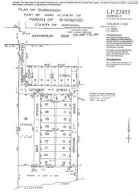
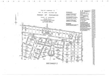 Ringwood and District Historical Society
Document - Subdivision Plan, Part of Crown Allotment 32B Parish of Ringwood, County of Mornington Vol 6051 Fol 111 - LP26857
LANDATA Land Victoria 2-sheet plan printout dated 9/11/1953.Sheet 1 includes Lynwood Avenue, Isabel Avenue, Braewood Avenue, Maple Court, and Heathwood Street, Ringwood East, Vic. Sheet 2 includes Braewood Avenue, Rotherwood Avenue, and Heathwood Street, Ringwood East, Vic. Additional markings include LP46598, CP173330, LP86847, LP213448, LP217511, LP207217, LP56241. -
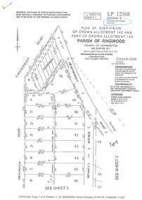 Ringwood and District Historical Society
Document - Subdivision Plan, LP12308 Crown Allotment 14C and Part of Crown Allotment 14A Parish of Ringwood, County of Mornington Vol 5378 Fol 511 - Circa 1927
LANDATA Land Victoria 4-sheet plan printout dated 2009.Sheet 1 includes Canterbury Road, Heathmont Road, Dickasons Road and Bennett Avenue, Heathmont. Additional markings include PC353066. Sheet 2 includes Heathmont Road, Bennett Avenue and Orchid Street, Heathmont. Additional markings include PS326369 and SP24567. Sheet 3 includes Dickasons Road and Bennett Avenue, Heathmont. Additional markings include LP46776, SP28005 and PS335189. Sheet 4 includes Dickasons Road, Bennett Avenue and Orchid Street, Heathmont. Additional markings include SP25998, SP31080, SP31780, SP25968, SP25969 and LP46475. -
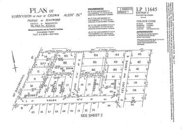 Ringwood and District Historical Society
Document - Subdivision Plan, LP11645 Part of Crown Allotment 26A, Parish of Ringwood, County of Mornington Vol 5164 Fol 1032616 - 1926
LANDATA Land Victoria 2-sheet plan printout dated 2009Sheet 1 includes Mount Dandenong Road, Valda Avenue and Velma Grove, Ringwood East. Additional markings include SP35514, SP22189, SP34206, SP35514, SP26794, PS319109, PS319010 and PS304868. Sheet 2 includes Mount Dandenong Road, Valda Avenue, Mirabel Avenue and Velma Grove, Ringwood East. Additional markings include SP26430, SP25320, PS341575, PS319110, PS319010, LP48415, SP22732, SP25844, PS304936 and PS304937. -
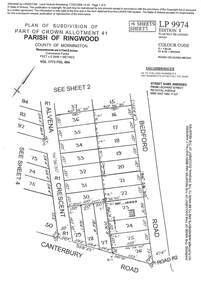 Ringwood and District Historical Society
Document - Subdivision Plan, LP9974 Part of Crown Allotment 41, Parish of Ringwood, County of Mornington Vol 1773 Fol 464 - 1924
LANDATA Land Victoria 4-sheet plan printout dated 2009Sheet 1 includes Alvena Crescent, Bedford Road and Canterbury Road, Heathmont. Additional markings include RP16869. Sheet 2 includes Alvena Crescent and Bedford Road, Heathmont. Additional markings include PS318390 and CP161633. Sheet 3 includes Bedford Road, Alvena Crescent and Royal Avenue, Heathmont. Additional markings include RP454. Street name amended from Leonard Street to Royal Avenue Vide Gaz 1962 P.427. Sheet 4 includes Alvena Crescent, Royal Avenue, Coleman Street and Canterbury Road, Heathmont. Additional markings include SP27861, PS305057, RP10566, SP34722 and LP116573. -
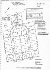 Ringwood and District Historical Society
Document - Subdivision Plan, LP17967 Part of Crown Allotment 33, Parish of Warrandyte, County of Evelyn, Vol 6141 Fol 054 - 1948
LANDATA Land Victoria plan printout dated 2008Map includes Wonga Road, Berea Avenue, Fyfe Avenue and Collett Avenue, Ringwood. Markings also include PS309215, LP143952, LP210020, LP24182, LP70960, SP29097, RP9235, SP19956 and LP113437. -
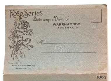 Flagstaff Hill Maritime Museum and Village
Postcard - Postcard Folder, scenes, George Rose, Rose Stereographic Company, Rose Series, Picturesque Views of Warrnambool Australia, 1880-1942
GEORGE ROSE 1861-1942: - George Rose was a well-known Victorian photographer, famous for his late 19th and early 20th century photography. He was born in Clunes, Victoria, and was in his 20th year when he founded Rose Stereograph Company in 1880. He took the opportunity of a popular trend of the times to produce stereographs, pairs of almost duplicate photographs that appeared in 3D when viewed in a handheld stereo viewer. By the 1920s, these lost their popularity, so he used his photographic skills to produce cards and postcards of scenes and people. The twelve photographs in the Rose postcard folders include locations connected to other items in our Collection, including the Valentine postcard folder in this set. The photographs are titled: - . The Avenue and War Memorial. Warrnambool. Vic. . The Blow-hole. Thunder Point. Warrnambool. Vic. . Botanical Gardens. Warrnambool. Vic. . Eagle Rock. Warrnambool. Vic. . The New Concrete Bridge and Breakwater. Warrnambool. Vic. . Liebig Street. Warrnambool. Vic. . Looking to Thunder Point. Warrnambool. Vic. . The Beach. Warrnambool. Vic. . Hopkins Falls. Warrnambool. Vic. . Shelly Beach. Warrnambool. Vic. . The Mouth of the Hopkins River. Warrnambool. Vic. . Panorama of Warrnambool, Vic. [Kepler Street towards Presbyterian Church on Spence St] This postcard folder shows scenes and places of interest in and around Warrnambool. The George Rose postcard folders in this set were produced in Victoria and include pictures taken by the renowned photographer between 1880 and 1942. Other postcards in our collection have photographs of the same or similar locations at different periods in time. Each postcard records a moment in history and is significant as a way to compare and show the changes in the local environment and community, building a story of the local history. The images record changes in the coastline, land, bay, buildings and other structures, roads, transportation and even the fashions of the times. This copy folder is one of a set of three. This folder has a green-grey textured rectangular card cover with a sketch of a rose on the front. The cover also contains the name of the postcard series, the location of the series' focus, the producer's details, and lines for adding an address. The folded cover contains a long, concertinaed page with six titled photographs on each side, totalling twelve. The folder contains scenes from Warrnambool and nearby popular areas, including Lady Bay, the Port of Warrnambool, the Warrnambool Breakwater, the Viaduct, the Merri River Footbridge, the Hopkins River Mouth, and Proudfoot’s and the Fanny Nelson/Flett boathouses. The cover has a sketch of a rose and inscriptions. The lithograph photographs were taken between 1880 and 1942 by well-known Victorian photographer George Rose, Rose Stereograph Company of Armadale, Victoria.Image: [Rose with rosebud and leaves] Printed: "Rose Series / Picturesque Views of / WARRNAMBOOL / AUSTRALIA" "PUBLISHED BY / ROSE STEREOGRAPH CO / ARMADALE. VIC."flagstaff hill maritime museum and village, great ocean road, shipwreck coast, warrnambool, flagstaff hill, flagstaff hill maritime museum, flagstaff hill maritime village, warramble, postcard, postcard folder, warrnambool scenes, picturesque views of warrnambool, lady bay, port of warrnambool, breakwater, warrnambool breakwater, viaduct, merri river footbridge, merri river suspension bridge, suspension footbridge, merri river mouth, hopkins river mouth, proudfoot's, fanny nelson, nelson's boatsheds, nelson's boathouse, boathouse, hopkins river boathouses, flett's boathouse, flett, george rose, image of a rose, rose series, rose stereograph co, rose stereographic company, lighograph, armadale victoria, lady bay beach, beach scene, lower light, concrete footbridge, 1922 footbridge, viaduct road, rose postcard, new concrete bridge, 1945, 1890, 1922, small footbridge, 1872 footbridge, 1872, merri river estuary, stingray bay, postcards, green-grey postcard folder, shipwrecked coast, maritime museum, souvenir, warrnambool local scenes, photography, local history, tourism, photographs, visitors, travel, scenes, mid-20th century, 1940s, 1950s, concertina fold, z-fold, 1880s, collection, correspondence, rose stereograph co armadale, victorian photographer, soldiers’ memorial, hopkins river, the cliffs at shelly beach, the road to sandy beach, pier, botanic gardens, post office, municipal buildings, merri river, proudfoot’s -
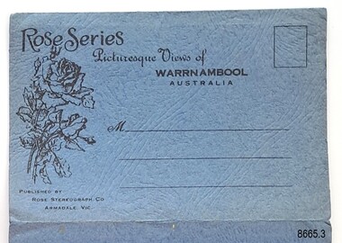 Flagstaff Hill Maritime Museum and Village
Postcard - Postcard Folder, scenes, George Rose, Rose Stereographic Company, Rose Series Picturesque Views of Warrnambool Australia, 1880-1942
GEORGE ROSE 1861-1942: - George Rose was a well-known Victorian photographer, famous for his late 19th and early 20th century photography. He was born in Clunes, Victoria, and was in his 20th year when he founded Rose Stereograph Company in 1880. He took the opportunity of a popular trend of the times to produce stereographs, pairs of almost duplicate photographs that appeared in 3D when viewed in a handheld stereo viewer. By the 1920s, these lost their popularity, so he used his photographic skills to produce cards and postcards of scenes and people. The twelve photographs in the Rose postcard folders include locations connected to other items in our Collection, including the Valentine postcard folder in this set. The photographs are titled: - . The Avenue and War Memorial. Warrnambool. Vic. . The Blow-hole. Thunder Point. Warrnambool. Vic. . Botanical Gardens. Warrnambool. Vic. . Eagle Rock. Warrnambool. Vic. . The New Concrete Bridge and Breakwater. Warrnambool. Vic. . Liebig Street. Warrnambool. Vic. . Looking to Thunder Point. Warrnambool. Vic. . The Beach. Warrnambool. Vic. . Hopkins Falls. Warrnambool. Vic. . Shelly Beach. Warrnambool. Vic. . The Mouth of the Hopkins River. Warrnambool. Vic. . Panorama of Warrnambool, Vic. [Kepler Street towards Presbyterian Church on Spence St] The photographs in this postcard folder were taken between 1880 and 1942 by the renowned Victorian photographer George Rose. The locations match photographs and postcards in our collection that were taken at different times. A comparison between them shows the changes over time in the land and bay, the buildings and other structures, transportation and even the fashions of the times, building the story of our local history.Postcard folder, Rose Series, blue cover. One of a set of three containing images of Warrnambool and district before 1942. Green folder, textured cardboard folder containing a Z-folded strip of white matte photographic paper with six black and white photographs on each side. Titles are printed below the images. The folder is secured by placing two tabs into two slots on the back cover to hold the cover in place and create an envelope shape. Three horizontal lines are printed on the front for the receiver’s address. There is a logo of a long-stemmed rose on the left side and inscriptions on the front cover. The lithograph photographs were taken between 1880 and 1942 by well-known Victorian photographer George Rose and published by Rose Stereograph Company of Armadale, Victoria. The folder contains scenes of popular areas at Warrnambool and nearby locations including Lady Bay, the Port of Warrnambool, the Warrnambool Breakwater, the Viaduct, the Merri River Footbridge, the Hopkins River Mouth, and Proudfoot’s and the Fanny Nelson/Flett boathouses. Image: [Rose with rosebud and leaves] Printed: "Rose Series / Picturesque Views of / WARRNAMBOOL / AUSTRALIA" "PUBLISHED BY / ROSE STEREOGRAPH CO / ARMADALE. VIC." flagstaff hill maritime museum and village, great ocean road, shipwreck coast, warrnambool, flagstaff hill, flagstaff hill maritime museum, flagstaff hill maritime village, warramble, postcard, postcard folder, warrnambool scenes, picturesque views of warrnambool, picturesque views of warramble, lady bay, port of warrnambool, breakwater, warrnambool breakwater, viaduct, merri river footbridge, merri river suspension bridge, suspension footbridge, merri river mouth, hopkins river mouth, proudfoot's, fanny nelson, nelson's boatsheds, nelson's boathouse, boathouse, hopkins river boathouses, flett's boathouse, flett, george rose, image of a rose, rose series, rose stereograph co, rose stereographic company, lighograph, armadale victoria, lady bay beach, beach scene, lower light, concrete footbridge, 1922 footbridge, viaduct road, rose postcard, new concrete bridge, 1945, 1890, 1922, small footbridge, 1872 footbridge, 1872, merri river estuary, stingray bay, postcards -
 Ringwood and District Historical Society
Document - Subdivision Plan, LP10477 Parish of Warrandyte, County of Evelyn, Vol 2453 Fol 574 - 1924
LANDATA Land Victoria plan printout circa 2010Part of Crown Allotment 30. Map includes Warrandyte Road, Kennedy Avenue and Wonga Road, Ringwood. Street name amended from Wonga Road to Loughnan Road 1940. Other markings include CP102182, CP171386, LP127934, PS349846, RP7582, PS309312,RP8679 and CP106336. -
 Ringwood and District Historical Society
Document - Subdivision Plan, LP23855 Part of Crown Allotment 14B, Parish of Ringwood, County of Mornington, Vol 6687 Fol 394 - 1952
LANDATA Land Victoria plan printout circa 2008Map includes Cuthbert Street, Orchard Grove, and Lowen Avenue (formerly part of Balfour Avenue), Heathmont. Other markings include SP25736, LP98835 and LP40209. -
 Whitehorse Historical Society Inc.
Article - National Trust of Australia (Victoria) Magazine, National Trust of Australia, Boongarry Avenue, Blackburn, Autumn 2023???
A photocopy of an article from the Victorian National Trust magazine pertaining to the inclusion of Boongarry Avenue for landscape classification within the Blackburn Lake and Bell Bird Streets, Blackburn.A photocopy of an article from the Victorian National Trust magazine pertaining to the inclusion of Boongarry Avenue for landscape classification within the Blackburn Lake and Bell Bird Streets, Blackburn.non-fictionA photocopy of an article from the Victorian National Trust magazine pertaining to the inclusion of Boongarry Avenue for landscape classification within the Blackburn Lake and Bell Bird Streets, Blackburn.boongarry avenue blackburn, blackburn lake, national trust of australia victoria -
 Ringwood and District Historical Society
Document - Subdivision Map, Part of Crown Sections 18, 19, 24 & 25, Parish of Warrandyte, County of Evelyn, Vol 5228 Fol 472 - 1926. (Park Orchards, Victoria)
A3 and A4 sized photocopies showing map section of land title showing streets, easements and allotment numbers, some with handwritten names and pricing notations circa mid 1950s.Map includes Valley Road, Granard Avenue, Park Road, Arundel Avenue, Hylton Avenue, Aviemore Avenue, Bowmore Avenue, Hopetoun Road, Colin Avenue, Daintree Avenue, Brucedale Crescent, Feversham Avenue, Ennismore Crescent, Iona Grove, Elgin Crescent and Gosford Crescent, Park Orchards, Victoria. -
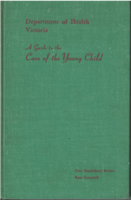 Linton and District Historical Society Inc
Textbook written by Dr Vera Scantlebury, A Guide to the Care of the Young Child, 1958
Vera Scantlebury Brown was born in Linton in 1889, a daughter of Dr George Scantlebury and his wife Catherine, née Baynes. Vera undertook medical training at Melbourne University between 1907 and 1913. After serving in the British Army Medical Unit during World War I, she worked in various positions in Melbourne hospitals and then studied in the US and Canada. In 1926 she was appointed Director of Infant Welfare by the recently established Victorian Department of Health, and became responsible for the development of maternal, infant and pre-school services in Victoria. In 2023 a statue of Vera Scantlebury was erected in Linton's Avenue of Honour in Denison Street. This copy of the book appears to have been owned/used by Barbara Safstrom of Linton.Textbook for nursing students and other health professionals. First compiled by Dr Vera Scantlebury Brown and published as a "Guide to Infant Feeding". Book revised (with Kate Campbell) in 1941, 1951 and 1958. Pages 346 p.: index, tables.Inscribed top right of front endpaper: 'Barbara Saftstrom / FF8269'.vera scantlebury, kate campbell, 'a guide to the care of the young child' [textbook] -
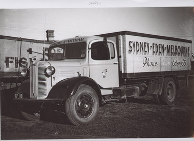 Lakes Entrance Historical Society
Photograph - Fishing Industry Lakes Entrance, Snowy Fanthams truck
Black and white photograph of Snowy Fanthams truck which transported fish Lakes Entrance Victoria. Also one black and white photograph of Snowy Fanthams truck parked beside Mitchelsons house on corner of Barkes Avenue and Lake Street Lakes Entrance on truck Sydney Eden Melbourne Phone Eden 65fishing industry, businesses, vehicles -
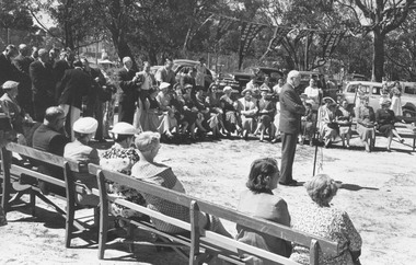 Ringwood and District Historical Society
Photograph, Official opening of Jubilee Park, Greenwood Avenue, Ringwood - 17 October, 1957
Black and white photograph (2 copies- 1 large, 1 small)Written on back of large copy: "Opening Jubilee Park- 17/10/57. Speaker Mr Bill Dowling (Chairman Board of Control, Cricket Victoria.)" Also in attendance was Mayor of Ringwood, Cr P. Vergers, and President Ringwood Cricket Club, Mr. C. Beaumont. -
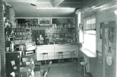 Lakes Entrance Historical Society
Photograph - Arceris Cafe Lakes Entrance, 1970 c
Black and white photograph taken inside Arceris small cafe on the corner of Esplanade and Barkes Avenue opposite the Post Office Lakes Entrance Victoriabusinesses -
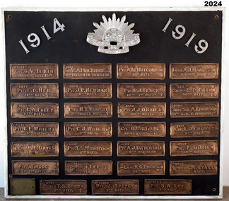 Bendigo Military Museum
Honour Board - EAST BENDIGO PRIMARY SCHOOL HONOUR BOARD WW1, original plaques, post WW1
The Bendigo East Primary School was opened in 1915. In 1916 it was decided to plant an ANZAC Avenue of trees and this was completed on 16 June 1916. The plaques were placed after WW1. The school was closed in 1998 and the plaques were relocated to the nearby White Hills Secondary College in Napier Street on this board. In the early 2000's the Honour Board was donated to what is now called the Bendigo Military Museum. One hundred years after planting, later in 2016 the trees were removed in controversial circumstances. On the board 8 never returned, there is 1 x "DCM" winner, 1 x "MC" winner and 1 x "MM" winner. There are 3 x Wright Brothers of which 2 never returned. The plaque states that the soldiers attended the school which is obvious they could not have due to the opening date. The following Heritage report suggests that the names were of individual soldiers who lived in the area. EXTRACT FROM HERITAGE COUNCIL VICTORIA 2016 SUBMISSIONS HEARING “The Bendigo East School (‘the school’) was officially opened by Mr Frank Tate, Director of Education, on 7 April 1916. Approximately two months later, on 16 June 1916, Arbor Day was celebrated at the school with the planting of an ‘Anzac Avenue’ along a path from the front gate on Strickland Road (‘the pathway’) to commemorate the landing of soldiers at Gallipoli. The school’s ‘Anzac Avenue’ was one of an estimated 37 known to have been planted by school children throughout Victoria during mid-1916 as part of a program led by the Education Department, which included a recommendation to schools on 18 May 1916 that commemorative avenues be planted (‘the 1916 plantings recommendation’). At around this time, avenues of honour were also planted across Victoria to commemorate fallen WWI soldiers (‘the wider commemorative plantings phenomenon’). There were other commemorative plantings at the Place away from the pathway (‘the other commemorative plantings’). Anzac Day was celebrated at the Place in the years subsequent to 1916 and on 11 December 1920 the school’s ‘Anzac Avenue’ was officially opened. Embossed copper plates, mounted on wood, were fixed in front of the trees in memory of individual soldiers from the district who had seen active service in WWI. There is evidence that as many as 32 plaques may have been made and affixed (‘the name plaques’). Plaques were removed from their locations at some stage before 1964, mounted on a board and displayed in the school building. These are now located and displayed at Bendigo Sub - Branch of the Returned Services League.” EAST BENDIGO HONOUR BOARD – COPPER PLAQUES (27 PLAQUES in total). 1. 2441 CPL G.V. LE KIM 60th BATT. M.M. (George Vincent LEE-KIM, born in Bendigo, Awarded Military Medal. RTA. NOK Father’s Address: C/- Strickland Rd, Bendigo). 2. 3821 PTE. E.B. HEM 20TH BATT. (Edward Bert Hem born in Bendigo. RTA. NOK Mother’s address: White Hills Post Office). 3. 3513 PTE. C.A. FOLEY 57th BATT. (Charles Albert Foley born in Bendigo. RTA. NOK Father’s address: Wilkie Street, Bendigo). 4. 5241 PTE. G. E. WRIGHT 6th BATT. † (George Edwin Wright born in Bendigo. KIA 8/12/1916. NOK Father’s address: 55 Charleston Rd. Bendigo). 5. 2663 L.CPL. N. E. DAVIS 60th BATT. (Norman Edward Davis born in Footscray. RTA. NOK Mother’s address: 193 Strickland Rd. Bendigo). 6. PTE. A. MOOG 16-6th BATT. † (5143 Adolph Moog born in Bendigo. Died of wounds received in action 8/12/1916, NOK Father’s address: Municipal Yards, Bendigo.) 7. 6515 SGT. W.A. BIRCHMORE DCM 11TH BATT. FIELD ARTILLERY (William Albert Birchmore born in Bendigo. Awarded DCM. RTA. NOK Mother’s address: Butler Street, California Gully) 8. 3924 PTE. J.P. NEWMAN 5TH BATT. † (392 (NAA) James Pausey Newman. Born in Bendigo. KIA 25/7/1916. NOK Father’s address Strickland Road, Bendigo) 9. 4865 PTE. H. T. NUGENT 5TH PIONEER BATT. † (also 4765 Hector Thomas Nugent born in Bendigo. KIA 26/11/1916. NOK Mother’s address: 55 Charleston Rd Bendigo). 10. 835 PTE. C.J. WRIGHT 7TH BATT. † (825(NAA) Charles Julian Wright. Born in Bendigo. KIA at Gallipoli 25/4/1915 NOK Father’s address 55 Charleston Rd Bendigo) 11. 5242 PTE. T.S. WRIGHT M.M. 6TH BATT. (Thomas Stanley Wright born in Bendigo. RTA. NOK Father’s address: 55 Charleston Road, Bendigo). 12. 13111 PTE. R.I. LEE 5TH FIELD AMBCE (19111 Robert Irwin Lee. Born in Kilcunda, Vic. RTA. NOK Wife’s address C/- Barnard Street, Bendigo) 13. 3731 DRIVER T.S. BROWN 5TH BATT.† (Thomas Sheridan Brown born in Bendigo. Died in the Field in France of Heart Failure. NOK Father’s address: Mundy Street, Bendigo). 14. 60999 PTE. J. SPENCE 5th BATT. (John Spence born in Bendigo. RTA. NOK Father’s address: 99 Talbot St, Brunswick) 15. 5127 PTE. S.A. LOY 7TH BATT. (Samuel Arthur John Loy. Born in White Hills, Bendigo. RTA Medical discharge. NOK Wife’s address C/- Hargreaves St Bendigo.) 16. 1649 PTE. A.M. HUTCHINSON 60TH BATT. (Alexander Morton Hutchison. (Note different spelling) born in Bendigo. RTA. NOK Mother’s address Wilkie Street, Bendigo). 17. 3035 PTE. R.J. FLACK 10TH – 7TH BATTs. † (Robert John Flack born in Bendigo. KIA France 17/8/1916. NOK Father’s address: Strickland Road, Bendigo). 18. 4558 PTE. J.J. O’BRIEN 60TH BATT.† (John James O’Brien born in Glenalbyn, Vic. KIA 28/9/1917. NOK Father’s address 68 Strickland Rd. Bendigo). 19. 5233 CPL. G. WHITTING MOTOR TRANSPT. COY. (George Whitting born in White Hills, Bendigo. RTA. NOK Mother’s address: 46 Baxter Street, Bendigo). 20. 5203 PTE. A.J. TATTERSALL 6TH BATTALION (Arthur James Tattersall born in Mandurang, Vic. RTA. NOK Wife’s address “Thornwell”, Bendigo East PO.) 21. 2ND LIEUT. K.G. EMONSON M.C. 38th BATT. (Keith Glanfield Emonson born in Sydney NSW. RTA – Medical discharge/ GSW head. NOK Father’s address: Strickland Road, Bendigo). 22. LIEUT. A.J. HAMPSON RAILWAY UNIT (Alfred John Hampson R/N 2300. Born in Bendigo. RTA. NOK wife’s address: 76 Addison St. Elwood, Vic). 23. 216 SIGNLR R.P. BROWN 38TH BATT † (Raymond Patrick Brown, born in Bendigo. KIA 28 May 1917. NOK. Mother’s address: 138 Mundy Street, Bendigo). 24. 15118 STAFF SGT. A. EMONSON 3RD L. H. F. AMBULANCE (Harry Allen Phipps Emonson born in Sydney NSW. RTA. NOK Father’s address Strickland Road, Bendigo, Vic). 25. 1724 CPL. L.J. CHAPPLE 5TH BATT. (Leslie John Chapple born in Bendigo. RTA. NOK Father’s address: Nolan Street, Bendigo) 26. 4557 PTE. E. O’BRIEN 60TH BATT. (Edward Charles O’ Brien, RTA. (NOK Father’s address: Strickland Rd, Bendigo). 27. 3557 SIGNLER F. H. LYALL 5TH BATT. (Francis Hubert Lyall born in Bendigo. RTA. NOK Father’s address: Strickland Rd, Bendigo). Honour Board, Bendigo East Primary School, timber backing with a white timber edging. At the top is a silver Rising Sun Badge with the dates in white "1914 & 1919". There are 27 bronze plaques, each has the Soldiers Regt Number, Name, Rank and Unit, for those that did not return there is a Cross added, if the Soldier won an award it is also added. At the bottom left hand corner is a brass plaque with details. Refer Aquisition for details. On the brass plaque, “These plaques were placed on the Avenue of trees at the school entrance on 20 December 1920. They were a memorial to those who enlisted from the Bendigo East School in the 1914 - 18 War. Mr R. J. Lee a Returned Soldier was Principal at this time”memorials-honour boards, military history-service records, metalcraft-bronze, east bendigo -
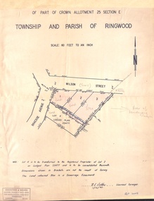 Ringwood and District Historical Society
Document - Plan of Subdivision, Part of Crown Allotment 25 Section E, Township and Parish of Ringwood - 1961
... , on Wilson Street and Braeside Avenue, Ringwood East, Victoria.... Street and Braeside Avenue, Ringwood East, Victoria. Part ...Map showing residential allotments numbered 1, 2, 3 and 4, on Wilson Street and Braeside Avenue, Ringwood East, Victoria.Signed and dated 1/12/1961. Rubber stamped Kirkpatrick & Webber, Licensed Surveyors, Civil Engineers & Town Planners, 225 Maroondah Highway, Ringwood, Telephone 870-0321. Ref 3438C. "Note: Lot 4 is to be transferred to the Registered Proprietor of Lot 2 on Lodged Plan 23477 and is to be consolidated therewith." Map also includes handwritten Estate Agent notations. -
 Ringwood and District Historical Society
Document - Map, Part of Crown Allotment 27C, Parish of Warrandyte, County of Evelyn, Ringwood, Victoria - c.1970
Photocopy of subdivision plan 75131 Vol 3439 Fol 712 showing numbered residential allotments with property dimensions.Surveyors and Consulting Engineers - O'Connor & Beveridge, Main Eltham Road, Lower Plenty, Tel. 432668. Rubber-stamped "Photocopy - Titles Office Complied 17 Feb 1970". Map includes Lockhart Road, Lansell Close, Terrara Place, Goldsmith Avenue, Park Hill Drive, Hilldale Close, and Elm Court, Ringwood, Victoria. -
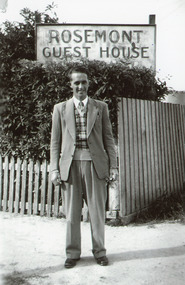 Lakes Entrance Historical Society
Photograph - Rosemont Guesthouse/Willis, Willis, Barbara, 1951c
Photo taken during honeymoon of Ron and Barbara Willis 1951Black and white photograph of Ron Willis, standing outside Fraser's Rosemont Guest House, Barkes Avenue. Guest house sign is behind a tall hedge and low picket fence. Ron is wearing clothing typical of 1950 era, with collar and tie, V-necked patterned pullover, light coloured two-piece suit and lace-up shoes. Lakes Entrance Victoriamotels, fences, clothing -
 Surrey Hills Historical Society Collection
Photograph
Frederick William and Mary Mawson (nee Mullard) migrated to Victoria from Manchester in 1882 on the sailing ship Holmsdale. They had two sons: William and John, and 5 daughters: Beatrice, Harriet, Ethel, Muriel and Winifred. By 1892, the family had moved to 14 Bona Vista Avenue, Surrey Hills and lived there for nearly 25 years until 1917.Decorative pewter frame with two sepia photographs of the ship 'Holmsdale'. Wooden frame underneath. Ship has 3 masts with 13 portholes on the side. frederick william mawson, mary mawson, holmsdale, surrey hills, ships, 14 bona vista avenue