Showing 1534 items
matching aerial photographs
-
 Glenelg Shire Council Cultural Collection
Photograph - Photograph - Aerial photograph of coastline around Portland, Victoria, c. 1954
... Photograph - Aerial photograph of coastline around Portland...Black and white aerial photograph of coastline around... Black and white aerial photograph of coastline around Portland ...Black and white aerial photograph of coastline around Portland. Black border, scale all sides, 5 rows of 3 't' at regular intervals. Mostly landFront: '607 - 52 ' - handwritten, white, border 'RUN 7 ' 'PORTLAND', printed, white, border -
Glenelg Shire Council Cultural Collection
Photograph - Photograph - aerial view of Portland, c. 1954
... Photograph - aerial view of Portland...Black and white aerial photograph of coastline around...', printed, white, border Black and white aerial photograph ...Black and white aerial photograph of coastline around Portland. Black border, scale all sides, 5 rows of 3 't' at regular intervals. Mostly landFront: '607 - 53 ' - handwritten, white, border 'RUN 7 ' 'PORTLAND', printed, white, borderaerial photography, central portland, portland harbour, south west coastline -
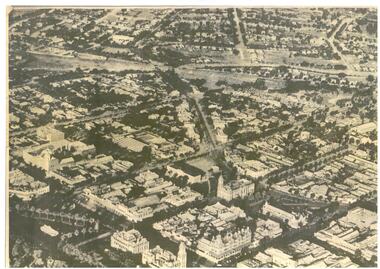
Bendigo Historical Society Inc.
Photograph - AERIAL PHOTOGRAPH OF THE CITY OF BENDIGO, April 1936
... AERIAL PHOTOGRAPH OF THE CITY OF BENDIGO...Photograph, Aerial Photograph of The City of Bendigo..., Melbourne. Photograph, Aerial Photograph of The City of Bendigo ...Photograph, Aerial Photograph of The City of Bendigo,was taken specially to mark the occasion of the United Country Party Conference of 1936. Issued with the compliments of the Proprietors of 'The Argus', April 1936Wilson and Mackinnon, Printers, Melbourne.photograph, streetscape, bendigo -
Port Melbourne Historical & Preservation Society
Financial record, Pat Grainger, Port Melbourne Historical & Preservation Society Annual Report 2012, Aug 2012
... Annual Report of the PMH&PS, 2012 A5 Pale grey with aerial... Annual Report of the PMH&PS, 2012 A5 Pale grey with aerial ...PMH&PS was incorporated in 1994, and from 1995 was required to hold an AGM and present an Annual Report. These were compiled, designed, printed on photocopier and bound by the Secretary, except for the Tenth anniversary edition and most recent edition, commercially photocopied.Annual Report of the PMH&PS, 2012 A5 Pale grey with aerial photograph of Port Melbourne, including Lagoon. Contains financial reports, list of members and photossocieties clubs unions and other organisations, port melbourne historical & preservation society, pmhps, annual report -
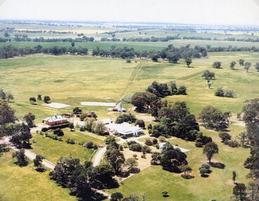 Stawell Historical Society Inc
Photograph, "Kirkella" Homestead 2001 -- Aerial Photo
... Aerial photograph of Kirkella homestead taken in 2001... grampians Aerial photograph of Kirkella homestead taken in 2001 ...Aerial photograph of Kirkella homestead taken in 2001. Shows Cricket pitch on Right Hand Side of photo partly surrounded by trees.stawell sport -
 Phillip Island and District Historical Society Inc.
Photograph, 1969
... Black & White Aerial photograph of the two bridges linking... San Remo 1969." Black & White Aerial photograph of the two ...One of 16 photographs and postcards donated by Mary KarneyBlack & White Aerial photograph of the two bridges linking San Remo with Newhaven, Phillip Island. San Remo Jetty and township bottom left foreground. Newhaven on the top.On back: "Two bridges San Remo 1969."the two bridges san remo, san remo to newhaven, phillip island bridges, mary karney -
Glenelg Shire Council Cultural Collection
Photograph - Photograph - aerial view of Portland coast, c. 1954
... Photograph - aerial view of Portland coast...Black and white aerial photograph of coastline around...', printed, white, lower border Black and white aerial photograph ...Black and white aerial photograph of coastline around Portland. Black border, scale all sides, 5 rows of 3 't' at regular intervals. Ocean, land with lakesFront: '820 -8' - handwritten, white, lower border 'RUN 5' 'PORTLAND', printed, white, lower borderaerial photography, central portland, portland harbour, south west coastline -
Port Melbourne Historical & Preservation Society
Photograph - Aerial view Maribyrnong and Yarra rivers and Coode Island, c. 1976
... Aerial photograph taken from above junction of Yarra... Aerial photograph taken from above junction of Yarra ...Donated to City of Port Melbourne by Councillor Russell GRIFFITHS.Aerial photograph taken from above junction of Yarra and Maribyrnong rivers showing oil and chemical storage farm at Coode Island and four container vessels at Swanson Dock.transport - shipping, piers and wharves - miscellaneous, swanson dock -
 Bendigo Historical Society Inc.
Map - BENDIGO MAP AERIAL VIEW, 1890s
... Map of Bendigo. Aerial View of Bendigo. This aerial... PHOTOGRAPH Aerial bendigo Map of Bendigo. Aerial View of Bendigo ...Map of Bendigo. Aerial View of Bendigo. This aerial photograph was taken specially to mark the pccasion of the United Country party conference of 1936. Issued with the complements of 'The Argus' April 1936.photograph, aerial, bendigo -
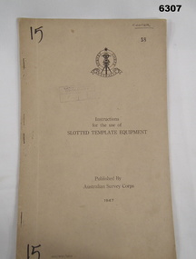 Bendigo Military Museum
Manual - Australian Survey Corps 1947 - Instructions for the use of Slotted Template Equipment, Australian Survey Corps, 1947
... from aerial photographs, and how the system works.... from aerial photographs, and how the system works. Royal ...This is an instruction manual describing in detail the construction of the templates used for producing map compilation sheets from aerial photographs, and how the system works.Foolscap size, soft carboard covers, 9 x numbered pages, 3 x fold out pages containing two photos on each. Australian Survey Corps Badge on cover. Stapled and re-stapled on Left hand edge.Front Cover, "15" Top Left and Bottom Left corner, "COOPER" and stamped "58" in Top Right, "AHQ/Misc/0015" Bottom Left Corner, Stamped "Eastern Command Survey Service copy 5"royal australian survey corps, rasvy, fortuna, army survey regiment, army svy regt, asr -
Tatura Irrigation & Wartime Camps Museum
Photograph, Aerial of Tatura 1930, 1930
... Early aerial photograph of township of Tatura. Main... Tatura the-murray Early aerial photograph of township of Tatura ...Early aerial photograph of township of Tatura. Main buildings and street can be seen. Copied by W. Purcell. Original held by donor A. Hampton.Black and white photograph taken from a small plane of township of Taturaon back: aerial photo of Tatura 1930. -
Glenelg Shire Council Cultural Collection
Photograph - Photograph - Aerial photograph of Portland harbour taken from the north east, 1967
... Photograph - Aerial photograph of Portland harbour taken...Black and white unframed aerial photograph of Portland... in existence) Black and white unframed aerial photograph of Portland ...Front: (no inscriptions) Back: Portland Harbour 1967/ No 6 berth under construction (ocean pier and railway pier still in existence)port of portland archives -
Glenelg Shire Council Cultural Collection
Photograph - Photograph - aerial view of Portland, c. 1954
... Photograph - aerial view of Portland...Black and white aerial photograph of coastline around..., white, border Black and white aerial photograph of coastline ...Black and white aerial photograph of coastline around Portland. Black border, scale all sides, 5 rows of 3 't' at regular intervals. Ocean on left, land on rightFront: '607 - 54 ' - handwritten, white, border 'RUN 7' 'PORTLAND', printed, white, borderaerial photography, central portland, portland harbour, south west coastline -
Glenelg Shire Council Cultural Collection
Photograph - Photograph - aerial view of Portland, c. 1954
... Photograph - aerial view of Portland...Black and white aerial photograph of coastline around...', printed, white, lower border Black and white aerial photograph ...Black and white aerial photograph of coastline around Portland. Black border, scale all sides, 5 rows of 3 't' at regular intervals. Ocean at right, land on left.Front: '820 - 7' -- handwritten, white, lower border 'RUN 5' 'PORTLAND', printed, white, lower borderaerial photography, central portland, portland harbour, south west coastline -
Glenelg Shire Council Cultural Collection
Photograph - Photograph - aerial view of Portland, c. 1954
... Photograph - aerial view of Portland...Black and white aerial photograph of coastline around..., white, border Black and white aerial photograph of coastline ...Black and white aerial photograph of coastline around Portland. Black border, scale all sides, 5 rows of 3 't' at regular intervals. 50/50 land and oceanFront: '607 - 51 ' - handwritten, white, border 'RUN 7' 'PORTLAND', printed, white, borderaerial photography, central portland, portland harbour, south west coastline -
Glenelg Shire Council Cultural Collection
Photograph - Photograph - aerial view of Portland, c. 1954
... Photograph - aerial view of Portland...Black and white aerial photograph of coastline around...', printed, white, border Black and white aerial photograph ...Black and white aerial photograph of coastline around Portland. Black border, scale all sides, 5 rows of 3 't' at regular intervals. 75/25 ocean to landFront: '784-146 ' - handwritten, white, border 'RUN - 7 A PORTLAND', printed, white, borderaerial photography, central portland, portland harbour, south west coastline -
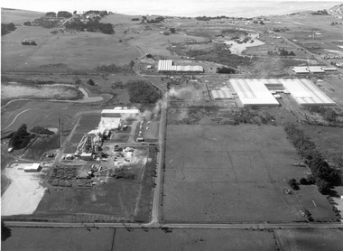
 Glenelg Shire Council Cultural Collection
Photograph, CSR Softwoods/Dartmoor Mill, n.d
... Aerial photograph of CSR Softwoods/Dartmoor Mill. Depicts 3... Authority archives. Port of Portland Aerial photograph of CSR ...Port of Portland Authority archives.port of portland -
 Glenelg Shire Council Cultural Collection
Photograph, CSR Softwoods/Dartmoor Mill, n.d
... Aerial photograph of CSR Softwoods/Dartmoor Mill. Depicts 3... Authority archives. Port of Portland Aerial photograph of CSR ...Port of Portland Authority archives.port of portland -
 Glenelg Shire Council Cultural Collection
Photograph, CSR Softwoods/Dartmoor Mill, n.d
... Aerial photograph of CSR Softwoods/Dartmoor Mill. Depicts 3... Authority archives. Port of Portland Aerial photograph of CSR ...Port of Portland Authority archives.port of portland -
Glenelg Shire Council Cultural Collection
Photograph - Photograph - aerial view of Portland, c. 1954
... Photograph - aerial view of Portland...Black and white aerial photograph of coastline around...', printed, white, border Black and white aerial photograph ...Black and white aerial photograph of coastline around Portland. Black border, scale all sides, 5 rows of 3 't' at regular intervals. 60/40 land to ocean.Front: '607 - 93 ' - handwritten, white, border 'RUN - 6 PORTLAND', printed, white, borderport of portland archives, aerial photography, portland harbour, south west coastline -
Glenelg Shire Council Cultural Collection
Photograph - Photograph - Aerial photograph of coastline, Portland Victoria, c. 1954
... Photograph - Aerial photograph of coastline, Portland...Black and white aerial photograph of coastline around... Black and white aerial photograph of coastline around Portland ...Black and white aerial photograph of coastline around Portland. Black border, scale all sides, 5 rows of 3 't' at regular intervals. 80/20 ocean to landFront: '784 - 147 ' - handwritten, white, border 'RUN 7 A PORTLAND', printed, white, border -
Glenelg Shire Council Cultural Collection
Photograph - Photograph - aerial view of Portland, c. 1954
... Photograph - aerial view of Portland...Black and white aerial photograph of coastline around..., white, border Black and white aerial photograph of coastline ...Black and white aerial photograph of coastline around Portland. Black border, scale all sides, 5 rows of 3 't' at regular intervals. 90/10 ocean to landFront: '784 - 148'- handwritten, white, border 'RUN 7 A PORTLAND', printed, white, borderaerial photography, central portland, portland harbour, south west coastline -
Glenelg Shire Council Cultural Collection
Photograph - Photograph - aerial view of Portland, c. 1954
... Photograph - aerial view of Portland...Black and white aerial photograph of coastline around..., white, border Black and white aerial photograph of coastline ...Black and white aerial photograph of coastline around Portland. Black border, scale all sides, 5 rows of 3 't' at regular intervals. 20% ocean, 80% land.Front: '820 -51' - handwritten, white, border 'RUN 6' 'PORTLAND', printed, white, borderaerial photography, central portland, portland harbour, south west coastline -
Glenelg Shire Council Cultural Collection
Photograph - Photograph - aerial view of Portland, c. 1954
... Photograph - aerial view of Portland...Black and white aerial photograph of coastline around...', printed, white, lower border Black and white aerial photograph ...Black and white aerial photograph of coastline around Portland. Black border, scale all sides, 5 rows of 3 't' at regular intervals. Buildings visible bottom leftFront: '607 -106' -- handwritten, white, lower border 'RUN 5' 'PORTLAND', printed, white, lower borderaerial photography, central portland, portland harbour, south west coastline -
Glenelg Shire Council Cultural Collection
Administrative record - Progress Report of Portland Harbour - Royal Commission of Victoria, 1925
... maps of Victoria, Portland and harbour and aerial photographs... and harbour and aerial photographs of Portland and Harbour ...Retrieved from the files of the former Maritime Discovery Centre Manager at the Portland Information Centre (A copy of this report is listed in the manifest from the Port of Portland when collection was offered in 1995)Front: Capt. J W Brown -inkport of portland -
 Ringwood and District Historical Society
Map - State Aerial Survey, Dandenong Ranges Area, Parts of Parishes of Nunawading, Warrandyte and Ringwood - 1956
... , July 1956, from aerial photographs and Cadastral Survey..., July 1956, from aerial photographs and Cadastral Survey ...Map of Ringwood North and parts of Mitcham, Donvale, Park Orchards and Ringwood East compiled by Dept of Lands and Survey, July 1956, from aerial photographs and Cadastral Survey information. Sheet 1, Ringwood A2D or 849 A2D Zone 7. Scale: 4 chains to 1 inch. Contour interval 20 feet. -
 Lakes Entrance Historical Society
Photograph - Lakes Entrance, Gippsland Ports, 2006 c
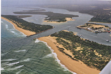
... Colour aerial photograph of the Entrance from Bass Strait...Also another copy of same photograph number 03864.1 same ...Also another copy of same photograph number 03864.1 same sizeColour aerial photograph of the Entrance from Bass Strait into the Gippsland Lakes including Bullock Island, Cunninghame Arm and looking NW across Rigby Island Lakes Entrance Victorialand settlement, waterways, lakes entrance -
 Lakes Entrance Historical Society
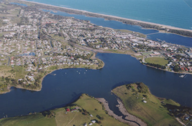
Photograph - North Arm Lakes Entrance, 2005 c
... Aerial Photograph...Colour aerial photograph showing Kalimna in foreground... and 03859.2 sizes 10 x 15 cm and 15 x 10 cm Aerial Photograph ...Also two colour photographs of North Arm area taken from Leigh and Judy Davies Blair Road Lakes Entrance number 03859.1 and 03859.2 sizes 10 x 15 cm and 15 x 10 cmColour aerial photograph showing Kalimna in foreground, North Arm, towhship, Cunninghame Arm and across to ninety mile beach and Bass Strait ocean beach Lakes Entrance Victoriaaerial photograph, settlement -
 Lakes Entrance Historical Society
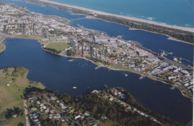
Photograph - North Arm Lakes Entrance, 2005
... Aerial Photograph...Colour aerial photograph showing North Arm, township...Aerial Photograph Aircraft Lakes Entrance Colour aerial ...Colour aerial photograph showing North Arm, township, eastern end of Cunninghame Arm across to the ocean beach, Ninety Mile beach, Bass Strait Lakes Entrance Victoriaaerial photograph, aircraft, lakes entrance -
Glenelg Shire Council Cultural Collection
Photograph - Photograph - aerial view of train track between Heywood and Rennick, 03/05/1952
... Photograph - aerial view of train track between Heywood and...Black and white aerial photographs (aerial survey record... photographs (aerial survey record print) of the railway line between ...Black and white aerial photographs (aerial survey record print) of the railway line between Heywood and Rennick (S.A. border) Taken for Victorian Railways, May 1952. Some photos have annotations later added to the front of the image in penVictorian Railways aerial survey record print of the railway line between Heywood and Rennick (S.A. border) Black and white, white vertical strip on imageFront: Annotations in red ink added at a later date Back: 'Heywood - Rennick 21579 - 19842 279m 57c ' - all black ink. Purple VR aerial survey stamp. '3 May 1952' - black stampvictorian railways, train track, transport, travel