Showing 1937 items
matching flood
-
 University of Melbourne, Burnley Campus Archives
Slide, Alan L. Mitchell, 1934
Floods in Orchard 1934 from Yarra River.alan l. mitchell, burnley gardens, floods, orchard -
Clunes Museum
Photograph, 2010
.1 Bridge was damaged and closed for repairs for about 6 months .2 Government bridge is higher and was not damaged.1 colour photograph of flooded creek at the newer bridge, water is hitting the bridge .2 colour photo of Government bridge during the floods, water is below the top of the bridge.1 T. Goldworthy 4th Sept. 2010 about midday .2 T. Goldworthy 4th Sept. 2010 about middaybridges, floods, photograph, goverment bridge -
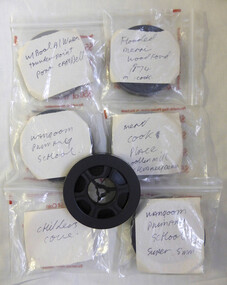 Warrnambool and District Historical Society Inc.
Film - Films, Eight reels of 8 mm film, Various mid to late 20th century
These films depict local scenes such as Childers Cove, Warrnambool Breakwater, Thunderpoint and Port Campbell. The other films depict events such as the 1974 Merri Flood and the demolition of the Woollen Mill chimney All these films provide historical, artistic and social views of the district. Eight reels of 8 mm film depicting local scenes and events. Most are shot in colour.Warrnambool events and locations. Wangoom Primary School (4 reels) Flooded Merri Woodford 1974 (1 reel) Warrnambool Breakwater, Thunderpoint, Port Campbell(1 reel) Childers Cove(1 reel) Woollen Mill Chimney Demolition(1 reel)warrnambool, childers cove, 1974 merri flood, warrnambool woollen mill -
 Kew Historical Society Inc
Photograph, Burke Road Bridge, 1930s
Without bridges, Kew remained cut off from the City of Melbourne, only being accessible by Punt. Private and public bridges were constructed from the 1850s, beginning with the Hawthorn Bridge linking Bridge and Burwood Roads. A bridge across the Yarra at Burke Road was created as early as 1873. Since that first wooden bridge, a number of later bridges, typically on concrete pylons have been built, in 1926 and again during the 1970s.Sepia, faded photograph of the Burke Road Bridge linking East Kew and Ivanhoe. The previous bridge, constructed in 1926 was submerged beneath the flood waters in the 1934 mega-flood of the Yarra.burke road bridge (kew), bridges -- river yarra -
University of Melbourne, Burnley Campus Archives
Slide, Alan L. Mitchell, 1934
More views of flood Mr. Geo Russ Foreman Mr. Frank Ellery in charge of Orchard flood did a lot of damage to Orchard.alan l. mitchell, burnley gardens, floods, george russ, foreman, frank ellery, orchards -
Glenelg Shire Council Cultural Collection
Photograph - Photograph - Casterton Flooding, c. 1946
SOURCED FROM CASTERTON TOWN HALL (FORMER SHIRE OF GLENELG) Sourced from Casterton Town Hall (Former Shire of Glenelg)Black and white photo of 1946 floods at Casterton, bridge with carBack: Purple photographer's stamp -
Clunes Museum
Document - DOCUMENTS, 13/14 JANUARY 2011
.1 2 PAGE TYPED LETTER TO CLUNES FIRE BRIGADE FROM GRAEME JOHNSTONE RE CLUNES FLOOD ON 13/14 JANUARY 2011 .2 TYPED EYE WITNESS ACCOUNT OF EXTREME WEATHER ON 13/14 JANUARY 2011 BY ANDREW JOHNSTONE .3 11 A4 PRINTED PHOTOGRAPHIC ENLARGEMENTS SHOWING CLUNES FLOOD AND FLOOD DAMAGE 13/14 JANUARY 2011 .4 ONE PHOTOGRAPH OF FLOODS IN CLUNES JANUARY 2011clunes flood 2011, clunes fire brigade, graeme johnstone, andrew johnstone -
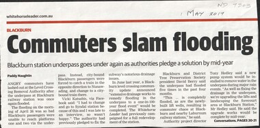 Whitehorse Historical Society Inc.
Article, Commuters slam flooding, 2017
The underpass at Blackburn railway station flooded again on the morning of Apr 26th preventing passengers from boarding city bound trains. This is the fifth time it has flooded in the past 4 months.level crossing removal authority, blackburn railway station -
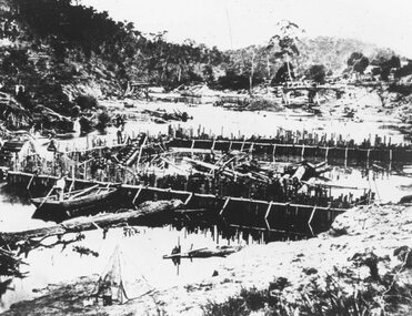 Ringwood and District Historical Society
Photograph, Warrandyte flooded coffer dam(undated)
Catalogue card reads, "Warrandyte flooded coffer dam" -
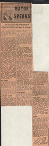 Bendigo Historical Society Inc.
Newspaper - LYDIA CHANCELLOR COLLECTION; MAYOR SPEAKS
A small green and white box containing cuttings from the Bendigo Advertiser dated 1968, 1969 titled, ' Mayor Speaks.' It relates to the Bendigo City Council's activities over the two years.Mayor T. Flood Speaks out 1968-9newspaper, bendigo advertiser, newspaper column, lydia chancellor, collections, newspaper, newspaper column -
 Bendigo Military Museum
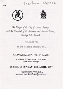
Pamphlet - COMMEMORATIVE PLAQUE 1997, C.1997
The Tom Flood Sports Centre was originally called The Bendigo Show Grounds. This plaque was unveiled by the City of Greater Bendigo & the Bendigo RSL Sub Branch to Commemorated the venue as a "Training Camp" during WW2. Order of Service was, Welcome, Mr Alan Holmes (President Bendigo RSL) Introduction of Recruits & Others associated with the Camp. A brief history of the Camp and Anecdotes was read by Mr Alan Holmes. Presentation and unveiling of the Plaque by Cr Barry Ackerman, Mayor City of Greater Bendigo. The wording: "Commemorating this site as an Australian Imperial Force Training Camp during WW2. "To the following Corps we pay Tribute" "10th AIF Training Depot" "Australian Army Medical Corps" "Australian Army Ordnance Corps" "Australian Army Service Corp". "Australian Electrical and Mechanical Engineers" Prayer of Thanksgiving & Commemoration by; Rev J. South. This was followed the "ODE, Last Post, One minutes Silence, Reveille and The National Anthem. As far as records available the Camp was first set up on 17.6.1940 with an Advance Party. The last Troops left there on 30.4.1943 for Ingleburn NSW, the Camp was vacated in May 1943. Pamphlet white paper, A4 folded making 4 pages, all print in black.On the front, "This Commemorative Plaque was unveiled at the Tom Flood Sports Centre Park Road Bendigo Sunday 27th April 1997"brsl, smirsl, plaque, tom flood, training camp -
 Bendigo Historical Society Inc.
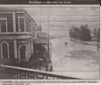
Newspaper - JENNY FOLEY COLLECTION: FLOODED
Bendigo Advertiser "way we were" from 1999. Flooded: looking towrd High Street from the Shamrock Hotel, the picture shows Pall Mall in flood after the rains in February 1871.newspaper, bendigo advertiser, the way we were -
 Lakes Entrance Historical Society
Photograph - Floods 1998 Lakes Entrance Victoria, Main Caravan Park, 2007 c
Colour photograph taken outside flooded buildings at Main Caravan Park Lakes Entrance Victoria. Also another colour photograph showing flooding inside toilet block at Main Caravan Parkfloods -
Eltham District Historical Society Inc
Photograph, Floods Falkiner Street, Eltham, 1956, 1956
Four photographs of floods in Falkiner Street area, Eltham, October 1956diamond creek, floods, falkiner street, main road, eltham -
Clunes Museum
Photograph
COPY OF PHOTOGRAPH OF FLOOD ON CRESWICK CREEK AT SUSPENSION BRIDGE BEHIND KEEBLE'S 8/9/1909 TALBOT RD CLUNES. IT WAS THIS BRIDGE THAT MR. WATSON WAS SO NEARLY CARRIED DOWN WITH THE RUSHING WATERS. HE WAS STANDING ON PART OF IT, WHEN IT BROKE AWAY AND HE MANAGED TO CLING TO TO THE REMAINSsuspension bridge flood, flood creswick creek, 1909 flood -
University of Melbourne, Burnley Campus Archives
Document, Improvements (Completed files), 1925-1935
Correspondence mainly re drainage, repairs after 1934 floods. etc.drainage, repairs, floods, improvements -
 Kew Historical Society Inc
Photograph, Floods, North Kew, 1923
Floods in North Kew in the vicinity of Willsmere Park, donated by Kerry Woollard.floods (kew), yarra river -
 Orbost & District Historical Society
black and white photograph, mid 1930s
This is a photograph of McKillop's Bridge probably taken just after its rebuilding. The current McKillop’s Bridge was built by the Country Roads Board in two stages between 1931-36, during which its height was raised after the original bridge superstructure was washed away in record floods of January 1934, prior to its original official opening. In its reconstructed form the original concrete abutments were turned into additional piers and the welded-steel trusses were cantilevered back over them to meet the new higher road approaches. "McKillops Bridge was Heritage listed due to its social and technological significance – the steel trusses' arc-welded construction technique was a pretty big deal in the 1930s. It was once an important route for cattlemen, who used the ford across the Snowy in the years preceding the bridge's existence"This is a pictorial record of McKillop's Bridge just after its construction.A black / white photograph of a wooden bridge across a river. At the bottom right is a man with his back to the camera. He is looking at flood debris on the bank. At the bottom left are two men near a pylon.on back - McKillops Bridgebridge-mckillop's snowy-river-bridge -
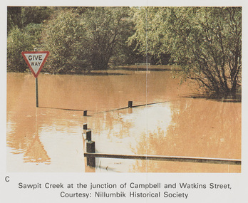 Eltham District Historical Society Inc
Work on paper (Sub-Item) - Photograph, Sawpit Creek at the junction of Campbell and Watkins Street, Diamond Creek Township, 8 April 1977
Colour photograph. Sawpit Creek at the junction of Campbell and Watkins Street, Diamond Creek Township. The Diamond Creek in flood at Diamond Creek township, 8 April 1977 Nillumbik Historical Society collectionflood, diamond creek, flooding, nillumbik historical society, give way, sawpit creek, campbell street, watkins street -
Glenelg Shire Council Cultural Collection
Postcard, c. 1946
Sourced from Casterton Town Hall former Shire of GlenelgBlack and white photo/postcard, showing ? Island Park Casterton during 1946 flood. Tractor in flooded yard near shed. Tin back fence with 'The World's Favourite' written on it. (Rest of advertisement underwater)Back: Purple photographer's stamp. 'Postcard' - purple -
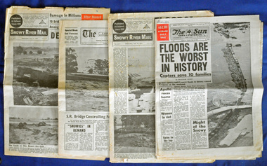 Orbost & District Historical Society
newspapers, February 1971
The 1971 floods at Orbost were the worst on record. At Jarrahmond the river rose to a height of 11 metres and on the flats spread to one and a half kilometres wide. Considerable damage was done to railway infrastructure, roads and farms. More information from the APRIL, 2008 newsletter by John Phillips. (see orbosthistory.com.au)These newspapers are contemporary records of a significant local event.Four newspapers and a set of clippings from various papers. They contain information and photographs pertaining to the 1971 floods in Orbost. 2557.1 is a Sun News Pictorial dated 8.2.1971. 2557.2 is a Snowy River Mail dated 10.2.1971. 2557.3 is an east Gippsland News dated 12.2.1971. 2557.4 is a Snowy River mail dated 12.2.1971 and 2557.5 is a collection of various clippings.floods-orbost-1971 newspaper snowy-river-mail sun-news-pictorial -
Glenelg Shire Council Cultural Collection
Postcard - Postcard - Flooding in Casterton, n.d
SOURCED FROM CASTERTON TOWN HALL (FORMER SHIRE OF GLENELG) Sourced From Casterton Town Hall (Former Shire of Glenelg)Black and white photo postcard. 1946 flood. Water halfway up tin fence, man standing on railing, tractor towing horse float, flooded shed, trees part submerged, no dry land visibleBack: Purple stamp - 'POSTCARD' Purple photographer's stamp -
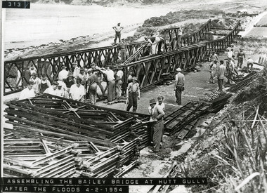 Lorne Historical Society
Photograph, Bailey Bridge at Hutt Gully
Assembling the Bailey Bridge at Hutt Gully after the floods 4/2/1954g.o.r.: bailey bridge: hutt gully: 4/2/1954 -
Glenelg Shire Council Cultural Collection
Photograph - Photograph - Casterton, Victoria, J.T. Somerville, c. 1946
SOURCED FROM CASTERTON TOWN HALL (FORMER SHIRE OF GLENELG)Black and white photo, looking across flood-covered bridge in Casterton, VictoriaBack: Purple photographer's stampcasterton, tourism, flooding -
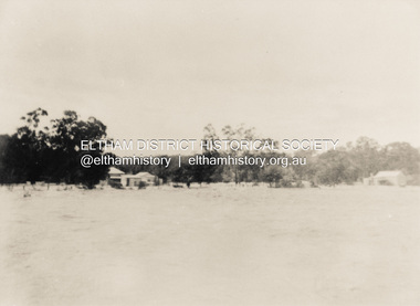 Eltham District Historical Society Inc
Photograph, North Eltham floods, 1924, 1924
Colour photograph of original showing Diamond Creek in flood at north Eltham 1924floods, diamond creek, eltham, north eltham -
Whitehorse Historical Society Inc.
Article, Nunawading residents see red over drainage scheme 'waste', 1993
Residents are concerned that the proposed easement drain in Esdale Street will not solve flooding problems.Residents are concerned that the proposed easement drain in Esdale Street will not solve flooding problems.Residents are concerned that the proposed easement drain in Esdale Street will not solve flooding problems.city of nunawading., esdale street, nunawading, springfield road, nunawading, swingler, phillipa, neal, andrew, drainage -
Ballarat Heritage Services
Film - MP4 video of Flooding Hepburn Mineral Springs Reserve 13 October 2022, LJ Gervasoni, Flooding Hepburn Mineral Springs Reserve 13 October 2022
MP4 video clips of flooding at Hepburn Mineral Springs 13 October 2022 -
 Melbourne Tram Museum
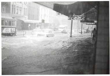
Photograph - Elizabeth St floods - Lonsdale St, Keith Kings, 17-2-1972
Photos shows the severity of the water washing down Elizabeth St following a major storm. Taken at or near the corner with Lonsdale St. In the second photo, W5 793, route 54, surrounded by water. Note the fruit vendors cart has crashed into a parked VW beetle.Yields information about a major rain event in Elizabeth St during 1972 and the impact it had on vehicles and tramway operations. Set of two Photographs - Elizabeth St floods - near Lonsdale St 1972Detailed description on rear. K S Kings stamp. tramways, flooding, floods, elizabeth sreet, events -
 Lakes Entrance Historical Society
Photograph, Lakes Post Newspaper, floods 1998, Lakes Entrance Victoria, 1/06/1998 12:00:00 AM
Colour photograph taken during floods of part of Esplanade Lakes Entrance Victoriafloods, gippsland lakes, natural disasters -
 Kew Historical Society Inc
Photograph - Construction of the Eastern Freeway (F19), Ron Setford, March 1972
Ron Setford and his wife Grace Setford lived in Tanner Avenue, East Kew, from c.1946 to c.1995. A keen photographer, he recorded the changing face of Kew over a 20 year period. Apart from 30 photographs of built structures and places in Kew dating from 1960 and 1961, 145 of his 35mm colour slides chronicle the development of the F19 (later renamed Eastern) Freeway through the Yarra Valley in Kew over a five year period from c.1972 to c.1977. This important collection was donated to the Society by his granddaughter in 2025.This collection of 175 35mm slides is of local and statewide significance, owing to its subject matter, particularly the major development of road transport infrastructure during the 1970s with the construction of the Eastern Freeway. The photographer also took care to annotate and date most of his slides which enable the researcher to pinpoint temporal and spatial locations."Eastern Freeway 6/72 / Willsmere Park flood underpass"ron setford, eastern freeway, f19 freeway